
 Search
March 14th Godzilla Discussion Part 2
Page 33 of 41 •  1 ... 18 ... 32, 33, 34 ... 37 ... 41
 ![]()
Re: March 14th Godzilla Discussion Part 2
![]() by jimv45 Sun Mar 12, 2017 3:48 pm
by jimv45 Sun Mar 12, 2017 3:48 pm
jimv45- Senior Enthusiast

- Posts : 1168
Join date : 2013-09-20
Re: March 14th Godzilla Discussion Part 2
![]() by gambri Sun Mar 12, 2017 3:49 pm
by gambri Sun Mar 12, 2017 3:49 pm
NJ Srong Members -
I hope you're having an enjoyable Sunday. If you have spare time, I suggest getting a head start on preparing for Tuesdays winter storm.
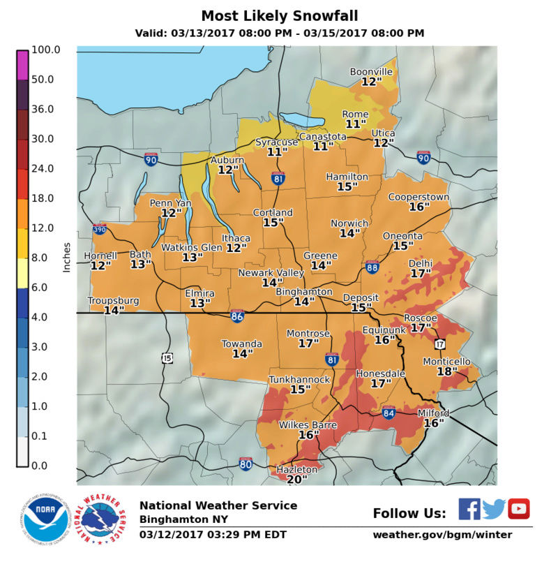
This afternoons weather models showed outputs I have not seen many times in my lifetime. The short range models and foreign models show a powerful storm capable of paralyzing the area. The trend I'm seeing in the upper levels is for the sub tropical jet stream to be stronger, which means a stronger southern energy, and the mid level trough is sharper. The combination of the two develops a dangerous surface low pressure system, likely under 980mb, found off the coast of NJ. Snow rates could be anywhere from 3 to 5 inches an hour at times. Sustained winds of 30-40mph with gusts in excess of 70mph from NYC and points S&E. Snow accumulations ranging from 18 to as much as 36 inches (the 30+ snow amounts are confined to Eastern PA, NW NJ, and SW NY on latest guidance). NYC and points S&E could see some sleet or rain mix at times, but accumulations will remain well over a foot of snow. Power outages are a concern of mine, especially for NJ and NYC Metro.
Now, there's still a full day of model runs to digest and changes in track could lessen impacst. However, this is a very dynamic set up and I think the EURO, CMC, UKIE, AND short range models are showing these types of conditions for a reason. This evening I will have a synopsis and 1st call snow map on the forum. Please prepare yourselves and inform friends and family of what we could possibly be dealing with on Tuesday.
gambri- Posts : 19
Join date : 2013-01-13
Re: March 14th Godzilla Discussion Part 2
![]() by SNOW MAN Sun Mar 12, 2017 3:51 pm
by SNOW MAN Sun Mar 12, 2017 3:51 pm
gambri wrote:heres Frank's email for those that arent signed up for newsletters:
NJ Srong Members -
I hope you're having an enjoyable Sunday. If you have spare time, I suggest getting a head start on preparing for Tuesdays winter storm.
This afternoons weather models showed outputs I have not seen many times in my lifetime. The short range models and foreign models show a powerful storm capable of paralyzing the area. The trend I'm seeing in the upper levels is for the sub tropical jet stream to be stronger, which means a stronger southern energy, and the mid level trough is sharper. The combination of the two develops a dangerous surface low pressure system, likely under 980mb, found off the coast of NJ. Snow rates could be anywhere from 3 to 5 inches an hour at times. Sustained winds of 30-40mph with gusts in excess of 70mph from NYC and points S&E. Snow accumulations ranging from 18 to as much as 36 inches (the 30+ snow amounts are confined to Eastern PA, NW NJ, and SW NY on latest guidance). NYC and points S&E could see some sleet or rain mix at times, but accumulations will remain well over a foot of snow. Power outages are a concern of mine, especially for NJ and NYC Metro.
Now, there's still a full day of model runs to digest and changes in track could lessen impacst. However, this is a very dynamic set up and I think the EURO, CMC, UKIE, AND short range models are showing these types of conditions for a reason. This evening I will have a synopsis and 1st call snow map on the forum. Please prepare yourselves and inform friends and family of what we could possibly be dealing with on Tuesday.
Thank you. Your a life saver.

SNOW MAN- Senior Enthusiast
- Posts : 1361
Reputation : 25
Join date : 2013-01-13
Age : 64
Location : Marshalls Creek Pa.
Re: March 14th Godzilla Discussion Part 2
![]() by nujerzeedevil Sun Mar 12, 2017 3:52 pm
by nujerzeedevil Sun Mar 12, 2017 3:52 pm
Jumping Jehosaphatamugs wrote:RPM NOT WAVERING HERE - THIS SI WHAT JEFF SMITH ON ABC IS SUING SINCE YESTERDAY


nujerzeedevil- Posts : 121
Reputation : 14
Join date : 2013-12-30
Location : Bayville, NJ
Re: March 14th Godzilla Discussion Part 2
![]() by aiannone Sun Mar 12, 2017 3:52 pm
by aiannone Sun Mar 12, 2017 3:52 pm

_________________
-Alex Iannone-

aiannone- Senior Enthusiast - Mod

- Posts : 4814
Reputation : 92
Join date : 2013-01-07
Location : Saint James, LI (Northwest Suffolk Co.)
Re: March 14th Godzilla Discussion Part 2
![]() by track17 Sun Mar 12, 2017 3:53 pm
by track17 Sun Mar 12, 2017 3:53 pm
track17- Posts : 454
Reputation : 4
Join date : 2016-01-09
Re: March 14th Godzilla Discussion Part 2
![]() by Frank_Wx Sun Mar 12, 2017 3:56 pm
by Frank_Wx Sun Mar 12, 2017 3:56 pm

EPS this afternoon give NYC Metro a 99% chance of seeing a foot or more of snow. This is the reason I pulled the trigger on Godzilla in advance. I can't believe the dynamics with this.
_________________
_______________________________________________________________________________________________________
CLICK HERE to view NJ Strong Snowstorm Classifications

Frank_Wx- Godzilla Seeker

- Posts : 21305
Reputation : 328
Join date : 2013-01-05
Age : 31
Location : Jersey City, NJ -

Re: March 14th Godzilla Discussion Part 2
![]() by WeatherBob Sun Mar 12, 2017 3:59 pm
by WeatherBob Sun Mar 12, 2017 3:59 pm

WeatherBob- Meteorologist

- Posts : 683
Reputation : 83
Join date : 2013-12-13
Location : Caldwell, NJ - NW Essex County - Altitude 500 FT
Re: March 14th Godzilla Discussion Part 2
![]() by jmanley32 Sun Mar 12, 2017 3:59 pm
by jmanley32 Sun Mar 12, 2017 3:59 pm
got ur email assuming winds of the magnitude u wrote of would b surround areas within nyc metro too like me. I want prepare elderly fsmily. The euro also showed those winds way inland. This is just crazy ex item and nervous same time. Looks like I'll miss chat tomorrow but ill.b check in.Frank_Wx wrote:jmanley32 wrote:Frank will u also make a wind map. I think with the euro output it would b helpful to see what u think. I was spot on with the big windstorm and euro winds aren't that off this close in.
Yes.
Everyone please check your emails. I sent a newsletter. If you did not receive one...check your settings and make sure you're set up to receive my emails.

jmanley32- Senior Enthusiast
- Posts : 20517
Reputation : 108
Join date : 2013-12-12
Age : 42
Location : Yonkers, NY
Re: March 14th Godzilla Discussion Part 2
![]() by Taffy Sun Mar 12, 2017 4:02 pm
by Taffy Sun Mar 12, 2017 4:02 pm
I took a look and your NWS is out of Philly. You do have high wind watch and a storm watch in effect. Your winds seem to be pretty much in alignment with mine (Upton) but they are a bit less. I'm not at all good at this at all so it is confusing that they haven't issued a blizzard watch for you.

Taffy- Pro Enthusiast

- Posts : 530
Reputation : 19
Join date : 2013-10-06
Location : Hopkinton, MA
Re: March 14th Godzilla Discussion Part 2
![]() by amugs Sun Mar 12, 2017 4:02 pm
by amugs Sun Mar 12, 2017 4:02 pm
_________________
Mugs
AKA:King: Snow Weenie
Self Proclaimed
WINTER 2014-15 : 55.12" +.02 for 6 coatings (avg. 35")
WINTER 2015-16 Total - 29.8" (Avg 35")
WINTER 2016-17 : 39.5" so far

amugs- Advanced Forecaster - Mod
- Posts : 15093
Reputation : 213
Join date : 2013-01-07
Age : 54
Location : Hillsdale,NJ
Re: March 14th Godzilla Discussion Part 2
![]() by Frank_Wx Sun Mar 12, 2017 4:03 pm
by Frank_Wx Sun Mar 12, 2017 4:03 pm
_________________
_______________________________________________________________________________________________________
CLICK HERE to view NJ Strong Snowstorm Classifications
Frank_Wx- Godzilla Seeker
- Posts : 21305
Reputation : 328
Join date : 2013-01-05
Age : 31
Location : Jersey City, NJ -
Re: March 14th Godzilla Discussion Part 2
![]() by nujerzeedevil Sun Mar 12, 2017 4:04 pm
by nujerzeedevil Sun Mar 12, 2017 4:04 pm
That is nothing short of sick Frank. Look at those area wide 12"+ amounts.....Frank_Wx wrote:
EPS this afternoon give NYC Metro a 99% chance of seeing a foot or more of snow. This is the reason I pulled the trigger on Godzilla in advance. I can't believe the dynamics with this.
nujerzeedevil- Posts : 121
Reputation : 14
Join date : 2013-12-30
Location : Bayville, NJ
Re: March 14th Godzilla Discussion Part 2
![]() by Frank_Wx Sun Mar 12, 2017 4:05 pm
by Frank_Wx Sun Mar 12, 2017 4:05 pm
amugs wrote:CHAT my students will have to participate!!
Have them register
_________________
_______________________________________________________________________________________________________
CLICK HERE to view NJ Strong Snowstorm Classifications
Frank_Wx- Godzilla Seeker
- Posts : 21305
Reputation : 328
Join date : 2013-01-05
Age : 31
Location : Jersey City, NJ -
Re: March 14th Godzilla Discussion Part 2
![]() by track17 Sun Mar 12, 2017 4:06 pm
by track17 Sun Mar 12, 2017 4:06 pm
track17- Posts : 454
Reputation : 4
Join date : 2016-01-09
Re: March 14th Godzilla Discussion Part 2
![]() by Math23x7 Sun Mar 12, 2017 4:06 pm
by Math23x7 Sun Mar 12, 2017 4:06 pm

Math23x7- Wx Statistician Guru

- Posts : 2379
Reputation : 68
Join date : 2013-01-08
Re: March 14th Godzilla Discussion Part 2
![]() by nujerzeedevil Sun Mar 12, 2017 4:07 pm
by nujerzeedevil Sun Mar 12, 2017 4:07 pm
NWS can SMD. Sorry, just sayin'....WeatherBob wrote:NWS New York is deciding where to put the Blizzard Warnings, I think they will soon post !!
nujerzeedevil- Posts : 121
Reputation : 14
Join date : 2013-12-30
Location : Bayville, NJ
Re: March 14th Godzilla Discussion Part 2
![]() by amugs Sun Mar 12, 2017 4:08 pm
by amugs Sun Mar 12, 2017 4:08 pm
_________________
Mugs
AKA:King: Snow Weenie
Self Proclaimed
WINTER 2014-15 : 55.12" +.02 for 6 coatings (avg. 35")
WINTER 2015-16 Total - 29.8" (Avg 35")
WINTER 2016-17 : 39.5" so far
amugs- Advanced Forecaster - Mod
- Posts : 15093
Reputation : 213
Join date : 2013-01-07
Age : 54
Location : Hillsdale,NJ
Re: March 14th Godzilla Discussion Part 2
![]() by jmanley32 Sun Mar 12, 2017 4:08 pm
by jmanley32 Sun Mar 12, 2017 4:08 pm
jmanley32- Senior Enthusiast
- Posts : 20517
Reputation : 108
Join date : 2013-12-12
Age : 42
Location : Yonkers, NY
Re: March 14th Godzilla Discussion Part 2
![]() by amugs Sun Mar 12, 2017 4:09 pm
by amugs Sun Mar 12, 2017 4:09 pm
Math23x7 wrote:The 15Z SREFs for LGA. As Frank would say: MADONNE!
JUNO AND NEMO ??????
JUST SAYING - COUGH COUGH!
_________________
Mugs
AKA:King: Snow Weenie
Self Proclaimed
WINTER 2014-15 : 55.12" +.02 for 6 coatings (avg. 35")
WINTER 2015-16 Total - 29.8" (Avg 35")
WINTER 2016-17 : 39.5" so far
amugs- Advanced Forecaster - Mod
- Posts : 15093
Reputation : 213
Join date : 2013-01-07
Age : 54
Location : Hillsdale,NJ
Re: March 14th Godzilla Discussion Part 2
![]() by billg315 Sun Mar 12, 2017 4:11 pm
by billg315 Sun Mar 12, 2017 4:11 pm

billg315- Advanced Forecaster - Mod
- Posts : 4469
Reputation : 185
Join date : 2015-01-24
Age : 50
Location : Flemington, NJ
Re: March 14th Godzilla Discussion Part 2
![]() by jmanley32 Sun Mar 12, 2017 4:12 pm
by jmanley32 Sun Mar 12, 2017 4:12 pm
careful man rules no bashing pro met I'm guessing frank will b talk u on tgst one.nujerzeedevil wrote:NWS can SMD. Sorry, just sayin'....WeatherBob wrote:NWS New York is deciding where to put the Blizzard Warnings, I think they will soon post !!
jmanley32- Senior Enthusiast
- Posts : 20517
Reputation : 108
Join date : 2013-12-12
Age : 42
Location : Yonkers, NY
Re: March 14th Godzilla Discussion Part 2
![]() by Guest Sun Mar 12, 2017 4:12 pm
by Guest Sun Mar 12, 2017 4:12 pm
880 am radio 6-12 NYC east. 12-18" NYC west
Fox News 6-12 NYC east 12-18 nj 18-24 easternmost PA
Useless trash
Guest- Guest
Re: March 14th Godzilla Discussion Part 2
![]() by amugs Sun Mar 12, 2017 4:14 pm
by amugs Sun Mar 12, 2017 4:14 pm
_________________
Mugs
AKA:King: Snow Weenie
Self Proclaimed
WINTER 2014-15 : 55.12" +.02 for 6 coatings (avg. 35")
WINTER 2015-16 Total - 29.8" (Avg 35")
WINTER 2016-17 : 39.5" so far
amugs- Advanced Forecaster - Mod
- Posts : 15093
Reputation : 213
Join date : 2013-01-07
Age : 54
Location : Hillsdale,NJ
Re: March 14th Godzilla Discussion Part 2
![]() by jmanley32 Sun Mar 12, 2017 4:14 pm
by jmanley32 Sun Mar 12, 2017 4:14 pm
No one is take seriously the met need go with wcs better safe than sorry.syosnow94 wrote:Latest forecasts.
880 am radio 6-12 NYC east. 12-18" NYC west
Fox News 6-12 NYC east 12-18 nj 18-24 easternmost PA
Useless trash
jmanley32- Senior Enthusiast
- Posts : 20517
Reputation : 108
Join date : 2013-12-12
Age : 42
Location : Yonkers, NY
Re: March 14th Godzilla Discussion Part 2
![]() by Frank_Wx Sun Mar 12, 2017 4:15 pm
by Frank_Wx Sun Mar 12, 2017 4:15 pm
_________________
_______________________________________________________________________________________________________
CLICK HERE to view NJ Strong Snowstorm Classifications
Frank_Wx- Godzilla Seeker
- Posts : 21305
Reputation : 328
Join date : 2013-01-05
Age : 31
Location : Jersey City, NJ -
Re: March 14th Godzilla Discussion Part 2
![]() by Grselig Sun Mar 12, 2017 4:15 pm
by Grselig Sun Mar 12, 2017 4:15 pm

Grselig- Senior Enthusiast
- Posts : 1408
Reputation : 140
Join date : 2013-03-04
Age : 54
Location : Wayne NJ
Page 33 of 41 • 1 ... 18 ... 32, 33, 34 ... 37 ... 41 ![]()