
 Search
March 14, 2017 Roidzilla 1st Call Snow Map / Synopsis
Page 1 of 33 • 1, 2, 3 ... 17 ... 33 ![]()

March 14, 2017 Roidzilla 1st Call Snow Map / Synopsis
![]() by Frank_Wx Sun Mar 12, 2017 8:58 pm
by Frank_Wx Sun Mar 12, 2017 8:58 pm
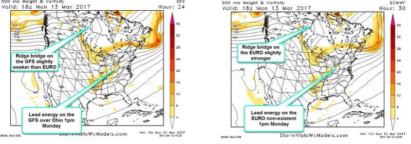
Even though majority of guidance disagrees with the GFS, I felt it was important to highlight the differences between it and the EURO. The GFS has the storm system moving faster and taking a track further east, while the EURO is slower and tucks the coastal low inside the 40/70 BM. Valid 1pm Monday, we see the GFS compared to the EURO having a weaker ridge-bridge out west and a piece of "lead" energy over Ohio. The ridge on the EURO is stronger and it does not show a 'phantom' energy over Ohio. As the run progresses, it's evident to me heights along the east coast are flatter on the GFS because the lead energy dampens them. Also, the trough is not as sharp due to the weaker ridging out west. These are key reasons why the GFS is a little faster with the storm.
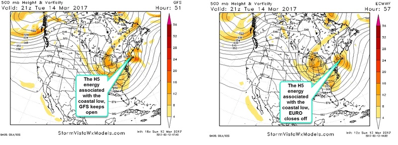
Valid 4pm Tuesday, the GFS shows an open 500mb vorticity over New England while the EURO closes off. The distinction is critical because the EURO shows a slower moving system and a stronger CCB over the area lasting well into the early evening hours. The precip shield overall on the EURO is expansive and potent. The open wave keeps the surface low moving at a quicker speed and the precip shield is not as impressive.
GFS 250mb winds:

UKMET 250mb winds:

Another key difference between the GFS and other models, such as the UKMET in this case, is where it places the upper level jet streak. The GFS is rounder with the trough and shows the strongest winds east, while the UKMET is sharper and has the strongest winds getting into the Mid-Atlantic. A sharper trough results in a system tracking closer to the coast. To be honest, the 250mb depiction of the GFS is not so bad. The fact it does not look better at the surface kinda confuses me. Since foreign models are very strong and bullish with this system, and the GFS is nonchalant, I tend to lean toward the foreign models especially when looking at the mid and upper level dynamics.

I like where the hi-res NAM puts the deform band as the low level center passes to our N&E. Other guidance such as the SREF and RGEM show something similar. The 850mb vort looks like it wants to track JUST off the coast of NJ. So a deform band N&W of there makes sense.
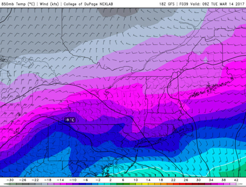
And because 850mb temperatures are expected to be colder than -6*C; and winds will be on the ligher side away from the coast, ratios will be 15:1 from eastern PA, NW NJ, SNY.

The closer to the coast you are, the higher wind gusts will be. The surface low pressure off the coast may deepen sub 980mb. This is where blizzard conditions are most likely expected. Drifts could approach 3 feet in some spots in NJ.
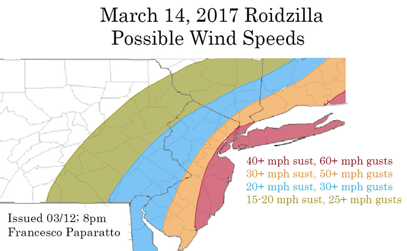
Here is a look of my wind forecast. I may be a little conservative in some areas, but I think the immediate coast is at risk of seeing power outages with the high winds and possibly heavy snow that will be falling at times.
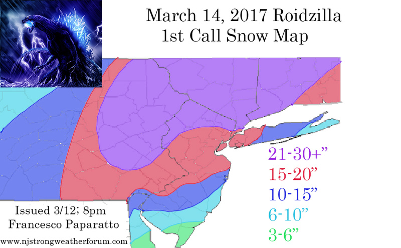
As briefly mentioned, I am not ready to put NYC and surrounding areas in the heaviest snowfall amounts. I am watching for an area of subsidence that may develop around this region. Also, I am not sure models are done trending west with this system. Areas from central NJ on east run into a risk of being dry-slotted at some point in the storm. Those N&W of NYC, especially NEPA, I feel are the bullseye at this time and where the Roidzilla snow amounts will be seen. THAT SAID, I do feel Godzilla snow amounts (12"+) will be fairly common region-wide.
As for coastal NJ and Long Island, you are an area I am watching closely. There is great uncertainty with the exact track of the surface low still and your area is most affected by this disagreement. The SREFS/EURO/RGEM, for example, have you warm for a period of time so you're seeing sleet/rain instead of snow. But with a deepening low off the coast, one may think it can pull the cold air inward and keep precip in the form of snow. We have to watch the trends very closely and see what happens.
This is a 1st call snow map for a reason. I have a feeling there will be changes to my final call, possibly drastic one's, since we're dealing with a monster of a storm. We should honestly sit back and appreciate what we're about to witness. A region-wide Godzilla in March is rare. And with the way this winter has gone I think we can appreciate anything we get.
And for the first time ever, I will be holding a live chat during lunch hours of 12pm-1pm tomorrow so we can get an idea of how afternoon model runs are trending with the storm. Please be sure to join, it should be fun!!
Have a great night!
Francesco Paparatto
_________________
_______________________________________________________________________________________________________
CLICK HERE to view NJ Strong Snowstorm Classifications

Frank_Wx- Godzilla Seeker

- Posts : 21305
Reputation : 328
Join date : 2013-01-05
Age : 31
Location : Jersey City, NJ -

Re: March 14, 2017 Roidzilla 1st Call Snow Map / Synopsis
![]() by Taffy Sun Mar 12, 2017 9:00 pm
by Taffy Sun Mar 12, 2017 9:00 pm

Taffy- Pro Enthusiast

- Posts : 530
Reputation : 19
Join date : 2013-10-06
Location : Hopkinton, MA
Re: March 14, 2017 Roidzilla 1st Call Snow Map / Synopsis
![]() by emokid51783 Sun Mar 12, 2017 9:01 pm
by emokid51783 Sun Mar 12, 2017 9:01 pm
emokid51783- Posts : 144
Reputation : 5
Join date : 2013-12-12
Age : 40
Location : Jersey City Heights, NJ
Re: March 14, 2017 Roidzilla 1st Call Snow Map / Synopsis
![]() by dsix85 Sun Mar 12, 2017 9:02 pm
by dsix85 Sun Mar 12, 2017 9:02 pm
dsix85- Pro Enthusiast
- Posts : 349
Reputation : 8
Join date : 2014-01-01
Location : New York
Re: March 14, 2017 Roidzilla 1st Call Snow Map / Synopsis
![]() by track17 Sun Mar 12, 2017 9:02 pm
by track17 Sun Mar 12, 2017 9:02 pm
track17- Posts : 454
Reputation : 4
Join date : 2016-01-09
Re: March 14, 2017 Roidzilla 1st Call Snow Map / Synopsis
![]() by mikeypizano Sun Mar 12, 2017 9:02 pm
by mikeypizano Sun Mar 12, 2017 9:02 pm

mikeypizano- Pro Enthusiast
- Posts : 1118
Reputation : 66
Join date : 2017-01-05
Age : 35
Location : Wilkes-Barre/Scranton, PA
Re: March 14, 2017 Roidzilla 1st Call Snow Map / Synopsis
![]() by jldio Sun Mar 12, 2017 9:04 pm
by jldio Sun Mar 12, 2017 9:04 pm
jldio- Posts : 19
Reputation : 0
Join date : 2013-02-11
Age : 56
Location : Wayne, NJ
Re: March 14, 2017 Roidzilla 1st Call Snow Map / Synopsis
![]() by billg315 Sun Mar 12, 2017 9:05 pm
by billg315 Sun Mar 12, 2017 9:05 pm

billg315- Advanced Forecaster - Mod

- Posts : 4462
Reputation : 185
Join date : 2015-01-24
Age : 50
Location : Flemington, NJ
Re: March 14, 2017 Roidzilla 1st Call Snow Map / Synopsis
![]() by weatherwatchermom Sun Mar 12, 2017 9:05 pm
by weatherwatchermom Sun Mar 12, 2017 9:05 pm

weatherwatchermom- Senior Enthusiast

- Posts : 3735
Reputation : 77
Join date : 2014-11-25
Age : 60
Location : Hazlet Township, NJ
Re: March 14, 2017 Roidzilla 1st Call Snow Map / Synopsis
![]() by Frank_Wx Sun Mar 12, 2017 9:05 pm
by Frank_Wx Sun Mar 12, 2017 9:05 pm
_________________
_______________________________________________________________________________________________________
CLICK HERE to view NJ Strong Snowstorm Classifications
Frank_Wx- Godzilla Seeker
- Posts : 21305
Reputation : 328
Join date : 2013-01-05
Age : 31
Location : Jersey City, NJ -
Re: March 14, 2017 Roidzilla 1st Call Snow Map / Synopsis
![]() by Scullybutcher Sun Mar 12, 2017 9:05 pm
by Scullybutcher Sun Mar 12, 2017 9:05 pm

Scullybutcher- Pro Enthusiast
- Posts : 543
Reputation : 16
Join date : 2013-02-06
Location : North Smithtown, western Suffolk county, long island
Re: March 14, 2017 Roidzilla 1st Call Snow Map / Synopsis
![]() by rb924119 Sun Mar 12, 2017 9:06 pm
by rb924119 Sun Mar 12, 2017 9:06 pm
rb924119- Meteorologist

- Posts : 6889
Reputation : 194
Join date : 2013-02-06
Age : 32
Location : Greentown, Pa
Re: March 14, 2017 Roidzilla 1st Call Snow Map / Synopsis
![]() by Mac003 Sun Mar 12, 2017 9:07 pm
by Mac003 Sun Mar 12, 2017 9:07 pm
Mac003- Posts : 23
Reputation : 0
Join date : 2013-12-14
Location : Clifton, NJ
Re: March 14, 2017 Roidzilla 1st Call Snow Map / Synopsis
![]() by Radz Sun Mar 12, 2017 9:08 pm
by Radz Sun Mar 12, 2017 9:08 pm

Radz- Pro Enthusiast
- Posts : 1028
Reputation : 17
Join date : 2013-01-12
Location : Cortlandt Manor NY
Re: March 14, 2017 Roidzilla 1st Call Snow Map / Synopsis
![]() by dsix85 Sun Mar 12, 2017 9:08 pm
by dsix85 Sun Mar 12, 2017 9:08 pm
dsix85- Pro Enthusiast
- Posts : 349
Reputation : 8
Join date : 2014-01-01
Location : New York
Re: March 14, 2017 Roidzilla 1st Call Snow Map / Synopsis
![]() by deadrabbit79 Sun Mar 12, 2017 9:08 pm
by deadrabbit79 Sun Mar 12, 2017 9:08 pm
deadrabbit79- Posts : 176
Reputation : 6
Join date : 2013-01-25
Location : Hartsdale, New York
Re: March 14, 2017 Roidzilla 1st Call Snow Map / Synopsis
![]() by nutleyblizzard Sun Mar 12, 2017 9:09 pm
by nutleyblizzard Sun Mar 12, 2017 9:09 pm

nutleyblizzard- Senior Enthusiast
- Posts : 1952
Reputation : 41
Join date : 2014-01-30
Age : 58
Location : Nutley, new jersey
Re: March 14, 2017 Roidzilla 1st Call Snow Map / Synopsis
![]() by SNOW MAN Sun Mar 12, 2017 9:10 pm
by SNOW MAN Sun Mar 12, 2017 9:10 pm

SNOW MAN- Senior Enthusiast
- Posts : 1361
Reputation : 25
Join date : 2013-01-13
Age : 64
Location : Marshalls Creek Pa.
Re: March 14, 2017 Roidzilla 1st Call Snow Map / Synopsis
![]() by oldtimer Sun Mar 12, 2017 9:10 pm
by oldtimer Sun Mar 12, 2017 9:10 pm
oldtimer- Senior Enthusiast
- Posts : 1103
Reputation : 14
Join date : 2013-01-16
Age : 78
Location : Port Jefferson Station Suffolk County
Re: March 14, 2017 Roidzilla 1st Call Snow Map / Synopsis
![]() by keliza52 Sun Mar 12, 2017 9:10 pm
by keliza52 Sun Mar 12, 2017 9:10 pm
______
Karen

keliza52- Posts : 51
Reputation : 0
Join date : 2013-12-08
Location : Hackettstown, NJ
Re: March 14, 2017 Roidzilla 1st Call Snow Map / Synopsis
![]() by jmanley32 Sun Mar 12, 2017 9:11 pm
by jmanley32 Sun Mar 12, 2017 9:11 pm

jmanley32- Senior Enthusiast
- Posts : 20513
Reputation : 108
Join date : 2013-12-12
Age : 42
Location : Yonkers, NY
Re: March 14, 2017 Roidzilla 1st Call Snow Map / Synopsis
![]() by EnyapWeather Sun Mar 12, 2017 9:12 pm
by EnyapWeather Sun Mar 12, 2017 9:12 pm
EnyapWeather- Posts : 57
Reputation : 0
Join date : 2017-03-12
Location : Bergen County NJ
Re: March 14, 2017 Roidzilla 1st Call Snow Map / Synopsis
![]() by MeganHyjack Sun Mar 12, 2017 9:12 pm
by MeganHyjack Sun Mar 12, 2017 9:12 pm
Frank_Wx wrote:I honestly need a drink. So mad...I got a new computer and lost my Roidzilla banner. Need to make a new one.
If you want me to make you one, I'm a graphic design major and would be happy to do so haha
MeganHyjack- Posts : 2
Reputation : 0
Join date : 2016-01-12
Re: March 14, 2017 Roidzilla 1st Call Snow Map / Synopsis
![]() by EnyapWeather Sun Mar 12, 2017 9:14 pm
by EnyapWeather Sun Mar 12, 2017 9:14 pm
I hope you can make it in time, we may not see another Roid in awhile.MeganHyjack wrote:Frank_Wx wrote:I honestly need a drink. So mad...I got a new computer and lost my Roidzilla banner. Need to make a new one.
If you want me to make you one, I'm a graphic design major and would be happy to do so haha
EnyapWeather- Posts : 57
Reputation : 0
Join date : 2017-03-12
Location : Bergen County NJ
Re: March 14, 2017 Roidzilla 1st Call Snow Map / Synopsis
![]() by frank 638 Sun Mar 12, 2017 9:15 pm
by frank 638 Sun Mar 12, 2017 9:15 pm
frank 638- Senior Enthusiast
- Posts : 2824
Reputation : 37
Join date : 2016-01-01
Age : 40
Location : bronx ny
Page 1 of 33 • 1, 2, 3 ... 17 ... 33 ![]()
|
|
|