
 Search
2017 General Tropical Cyclone Discussion Thread
Page 2 of 40 •  1, 2, 3 ... 21 ... 40
 ![]()
Re: 2017 General Tropical Cyclone Discussion Thread
![]() by jmanley32 Sat Jul 01, 2017 7:16 pm
by jmanley32 Sat Jul 01, 2017 7:16 pm
jmanley32- Senior Enthusiast

- Posts : 20513
Join date : 2013-12-12
Re: 2017 General Tropical Cyclone Discussion Thread
![]() by jmanley32 Sat Jul 01, 2017 7:26 pm
by jmanley32 Sat Jul 01, 2017 7:26 pm
jmanley32- Senior Enthusiast
- Posts : 20513
Join date : 2013-12-12
Re: 2017 General Tropical Cyclone Discussion Thread
![]() by Snow88 Sun Jul 02, 2017 8:46 pm
by Snow88 Sun Jul 02, 2017 8:46 pm

Snow88- Senior Enthusiast
- Posts : 2193
Reputation : 4
Join date : 2013-01-09
Age : 35
Location : Brooklyn, NY
Re: 2017 General Tropical Cyclone Discussion Thread
![]() by weatherwatchermom Thu Jul 06, 2017 11:05 am
by weatherwatchermom Thu Jul 06, 2017 11:05 am

weatherwatchermom- Senior Enthusiast
- Posts : 3733
Reputation : 77
Join date : 2014-11-25
Age : 60
Location : Hazlet Township, NJ
Re: 2017 General Tropical Cyclone Discussion Thread
![]() by sabamfa Thu Jul 06, 2017 1:20 pm
by sabamfa Thu Jul 06, 2017 1:20 pm
sabamfa- Pro Enthusiast

- Posts : 246
Reputation : 2
Join date : 2013-11-05
Age : 37
Location : Wayne, NJ
Re: 2017 General Tropical Cyclone Discussion Thread
![]() by jmanley32 Thu Jul 06, 2017 7:15 pm
by jmanley32 Thu Jul 06, 2017 7:15 pm

jmanley32- Senior Enthusiast
- Posts : 20513
Reputation : 108
Join date : 2013-12-12
Age : 42
Location : Yonkers, NY
Re: 2017 General Tropical Cyclone Discussion Thread
![]() by sroc4 Fri Jul 07, 2017 7:34 am
by sroc4 Fri Jul 07, 2017 7:34 am

_________________
"In weather and in life, there's no winning and losing; there's only winning and learning."
WINTER 2012/2013 TOTALS 43.65"WINTER 2017/2018 TOTALS 62.85" WINTER 2022/2023 TOTALS 4.9"
WINTER 2013/2014 TOTALS 64.85"WINTER 2018/2019 TOTALS 14.25" WINTER 2023/2024 TOTALS 13.1"
WINTER 2014/2015 TOTALS 71.20"WINTER 2019/2020 TOTALS 6.35"
WINTER 2015/2016 TOTALS 35.00"WINTER 2020/2021 TOTALS 37.75"
WINTER 2016/2017 TOTALS 42.25"WINTER 2021/2022 TOTALS 31.65"

sroc4- Admin

- Posts : 8331
Reputation : 301
Join date : 2013-01-07
Location : Wading River, LI
Re: 2017 General Tropical Cyclone Discussion Thread
![]() by jmanley32 Fri Jul 07, 2017 10:00 am
by jmanley32 Fri Jul 07, 2017 10:00 am
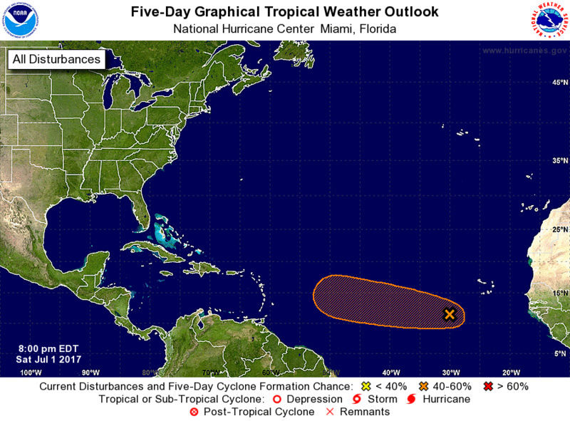
sroc4 wrote:Not too fast Jman. There is a fairly robust moisture laden wave about to exit the W African coast. You can see in the loop below fairly high precipitable water coming off the coast. As long as the wave isn't too fast to catch the dry air out ahead it should have decent conditions to work with once out over the open waters of the MDR(main development region). We shall see. Obv a long way to go, but this one may have to be watched in the area of the Antilles in about a week +/-.
I said mainly quiet but yes forgot to mention that wave and the GFS has been show that one heading to the US infantasy range but just checked the Euro and it has a 972mb hurricane hitting PR in 10 days. Since the Euro is already bullish on this it may very well be a big one to watch. Don, which is the next name has some significance in my life at this time, call me superstitious but thats also my deceased grandfathers name and he was no one to mess with LOL. Maybe he is coming to pay me a visit, hey he was the one to give me my first weather radio!
jmanley32- Senior Enthusiast
- Posts : 20513
Reputation : 108
Join date : 2013-12-12
Age : 42
Location : Yonkers, NY
Re: 2017 General Tropical Cyclone Discussion Thread
![]() by jmanley32 Fri Jul 07, 2017 10:04 am
by jmanley32 Fri Jul 07, 2017 10:04 am
jmanley32- Senior Enthusiast
- Posts : 20513
Reputation : 108
Join date : 2013-12-12
Age : 42
Location : Yonkers, NY
Re: 2017 General Tropical Cyclone Discussion Thread
![]() by jmanley32 Fri Jul 07, 2017 8:26 pm
by jmanley32 Fri Jul 07, 2017 8:26 pm
jmanley32- Senior Enthusiast
- Posts : 20513
Reputation : 108
Join date : 2013-12-12
Age : 42
Location : Yonkers, NY
Re: 2017 General Tropical Cyclone Discussion Thread
![]() by nutleyblizzard Fri Jul 07, 2017 8:54 pm
by nutleyblizzard Fri Jul 07, 2017 8:54 pm
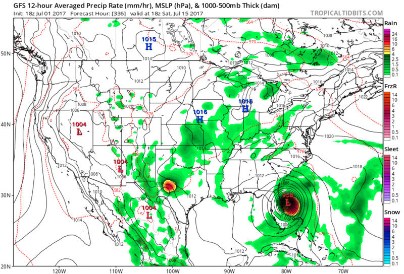
Well I for one is wishing it. This board has been dead for too far long... what the GFS depicts would certainly raise the stakes. Don't get me wrong JMAN I'm not wishing death and destruction but there's nothing better than the thrill of tracking a major cane or blizzard!jmanley32 wrote:18z gfs fantasy range is really scary for the area 955mb guessing cat 3 cane headed due North to LI. If we knew the gfs were ever right which almost never is I'd prepare now. I always said a li expess redux was going to happen one day. Don't get all bent out of shape I'm not wishing that to happen to anyone but boy would that be one nail biting one to track. Nhc should b mentioning this wave soon.

nutleyblizzard- Senior Enthusiast
- Posts : 1952
Reputation : 41
Join date : 2014-01-30
Age : 58
Location : Nutley, new jersey
Re: 2017 General Tropical Cyclone Discussion Thread
![]() by jmanley32 Fri Jul 07, 2017 10:21 pm
by jmanley32 Fri Jul 07, 2017 10:21 pm
nutleyblizzard wrote:Well I for one is wishing it. This board has been dead for too far long... what the GFS depicts would certainly raise the stakes. Don't get me wrong JMAN I'm not wishing death and destruction but there's nothing better than the thrill of tracking a major cane or blizzard!jmanley32 wrote:18z gfs fantasy range is really scary for the area 955mb guessing cat 3 cane headed due North to LI. If we knew the gfs were ever right which almost never is I'd prepare now. I always said a li expess redux was going to happen one day. Don't get all bent out of shape I'm not wishing that to happen to anyone but boy would that be one nail biting one to track. Nhc should b mentioning this wave soon.
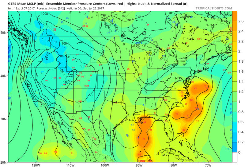
That is true, and i said it would be quite a thing to track, if the wave holds i expect a chances area to go up in the next several days. That GFS run was very close to the LI express track. 955mb COULD be cat 4 depending on the high resolution and winds, but thats 384 hrs away lol, through day 10 it def develops and that entire run it hit a lot of areas but gets most intense heading up EC, thats interesting.
jmanley32- Senior Enthusiast
- Posts : 20513
Reputation : 108
Join date : 2013-12-12
Age : 42
Location : Yonkers, NY
Re: 2017 General Tropical Cyclone Discussion Thread
![]() by jmanley32 Fri Jul 07, 2017 10:25 pm
by jmanley32 Fri Jul 07, 2017 10:25 pm

jmanley32- Senior Enthusiast
- Posts : 20513
Reputation : 108
Join date : 2013-12-12
Age : 42
Location : Yonkers, NY
Re: 2017 General Tropical Cyclone Discussion Thread
![]() by jmanley32 Fri Jul 07, 2017 10:29 pm
by jmanley32 Fri Jul 07, 2017 10:29 pm
jmanley32- Senior Enthusiast
- Posts : 20513
Reputation : 108
Join date : 2013-12-12
Age : 42
Location : Yonkers, NY
Re: 2017 General Tropical Cyclone Discussion Thread
![]() by sroc4 Sat Jul 08, 2017 9:10 am
by sroc4 Sat Jul 08, 2017 9:10 am
In looking at tropical systems you have to look carefully at current observations/conditions (ie: SST, trade winds, Pwats, SAL, wind shear, vorticity, upper level divergence, low level convergence, positioning/timing/strength of mean troughs and ridges, MJO phase, SOI to name just a few) in and around any given topical wave or entity and try to predict what/how these factors are/will affect a tropical entity in the 3-5days time frame at most. Last year was a prime example of how quickly these parameters can shift, change, and/or not change relative to what models thought were going to happen in the short and medium ranges. Case in point: Hurricane Hermine. What it was going to do, where it was going to go, and how strong it was from the beginning in the Fla Straits, to the Gulf Coast landfall, to where and how it would track off then up the EC was in question beyond 2-3days the entire time.

If even one of these parameters is not handled correctly on a given model the margin of error on the soln of a tropical entity grows exponentially with time as a result; esp when looking at a wave or weaker tropical system. The stronger a system becomes the higher probability it will do what IT wants to do vs being dictated by what the environmental conditions surrounding it would want it to do. So for now we watch the MDR(Main Development Region--between western African coast and the Eastern Caribbean Islands) as there seems to be a fairy active African wave train for the moment, with warm SST anomalies in the MDR, an MJO flirting with phase 2, and broad scale ENSO neutral like conditions which tends to lead to a favorable Walker Cell configuration for Atlantic basin tropical development. Even if one of these tropical waves does not develop in the MDR if they survive as they continue west into the Caribbean Ocean, GOM, or N of the lesser/greater Antilles towards the Bahamas and EC they can still develop there too should conditions dictate. For now development is not imminent.
_________________
"In weather and in life, there's no winning and losing; there's only winning and learning."
WINTER 2012/2013 TOTALS 43.65"WINTER 2017/2018 TOTALS 62.85" WINTER 2022/2023 TOTALS 4.9"
WINTER 2013/2014 TOTALS 64.85"WINTER 2018/2019 TOTALS 14.25" WINTER 2023/2024 TOTALS 13.1"
WINTER 2014/2015 TOTALS 71.20"WINTER 2019/2020 TOTALS 6.35"
WINTER 2015/2016 TOTALS 35.00"WINTER 2020/2021 TOTALS 37.75"
WINTER 2016/2017 TOTALS 42.25"WINTER 2021/2022 TOTALS 31.65"
sroc4- Admin
- Posts : 8331
Reputation : 301
Join date : 2013-01-07
Location : Wading River, LI
Re: 2017 General Tropical Cyclone Discussion Thread
![]() by rb924119 Sat Jul 08, 2017 1:34 pm
by rb924119 Sat Jul 08, 2017 1:34 pm
rb924119- Meteorologist

- Posts : 6889
Reputation : 194
Join date : 2013-02-06
Age : 32
Location : Greentown, Pa
Re: 2017 General Tropical Cyclone Discussion Thread
![]() by jmanley32 Sun Jul 09, 2017 12:41 am
by jmanley32 Sun Jul 09, 2017 12:41 am
jmanley32- Senior Enthusiast
- Posts : 20513
Reputation : 108
Join date : 2013-12-12
Age : 42
Location : Yonkers, NY
Re: 2017 General Tropical Cyclone Discussion Thread
![]() by sroc4 Sun Jul 09, 2017 10:14 am
by sroc4 Sun Jul 09, 2017 10:14 am
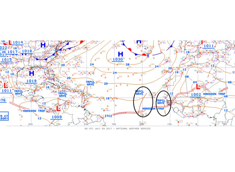
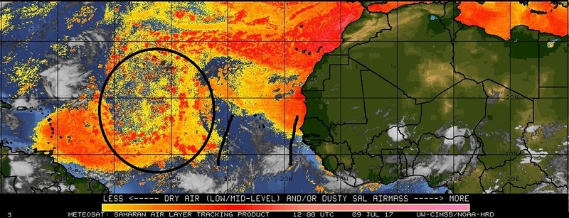
sroc4 wrote:Not too fast Jman. There is a fairly robust moisture laden wave about to exit the W African coast. You can see in the loop below fairly high precipitable water coming off the coast. As long as the wave isn't too fast to catch the dry air out ahead it should have decent conditions to work with once out over the open waters of the MDR(main development region). We shall see. Obv a long way to go, but this one may have to be watched in the area of the Antilles in about a week +/-.
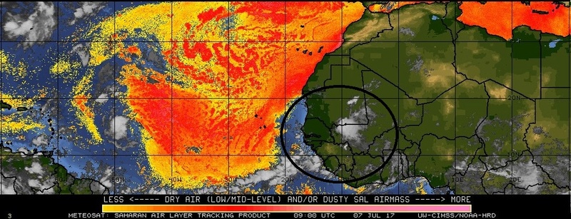
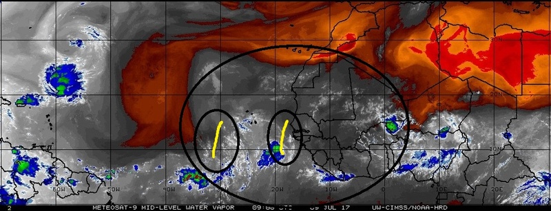
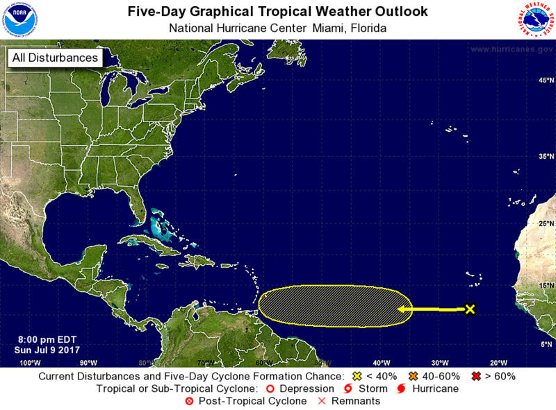
Here is an update on the tropical wave that was about to exit the African coast I mentioned on Friday. As you can see below this wave is now around 30W Longitude and there is a second wave just exiting the African coast.
Now if you have been following the GFS and Euro the last couple of days you would have noticed the GFS has fairly consistently wanted to develop this wave into an organized tropical system east of the Lesser Antilles and eventually land falling as a trop storm or hurricane somewhere over the Island chain in about 5-7days; whereas, the Euro consistently keeps it as an open wave giving the Islands of the Lesser Antilles nothing more than windy conditions and rain and thunderstorms in this same time frame. Ironically the GFS soln has had support by its ensembles, and the Europeans weaker soln is also backed up by its own ensembles. So which soln is correct?
Well lets look at just a few conditions. First lets look at what's going on at a broad scale.
The base state of the SOI(southern Oscillation Index) has been weakly negative with the 30day Avg flirting with El Nino status briefly for a few days; however, since about June 25th a mostly positive to weakly positive bursts has been occurring. Overall the SOI over the last 30-60days has fluctuated back and forth with negative and positive bursts leaving both the 30 and 90 day Base states in neutral territory with a negative lean.
https://www.longpaddock.qld.gov.au/seasonalclimateoutlook/southernoscillationindex/30daysoivalues/
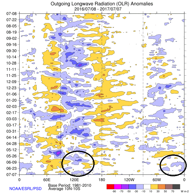
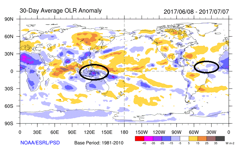
Overall the Walker cell configuration associated with the current ENSO status has been consistent with a La Nina or Neutral ENSO conditions as far as the "text books" would state as seen by the trends of the OLR(outgoing longwave radiation) over the last month. This makes sense given that we are coming off a weak La Nina over the winter and current SST, SOI, and ONI values all are consistent with neutral conditions. The cooler colors on the OLR map indicates where broad area of convection(Convection means rising air) in the trop Pac is occurring; whereas, the warmer colors indicate where broad areas of sinking air in the trop pac is occurring. If there is rising air in one area then there will be sinking air in another. The Walker cells are these broad areas of rising and sinking air. To read more about what the Walker Cell is see here: https://www.climate.gov/news-features/blogs/enso/walker-circulation-ensos-atmospheric-buddy


Again as you can see from the images about La Nina or neutral ENSO conditions tends to favor rising air in the Atlantic basins. The current OLR maps support this tendency.
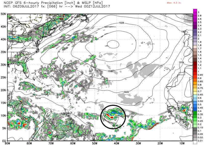
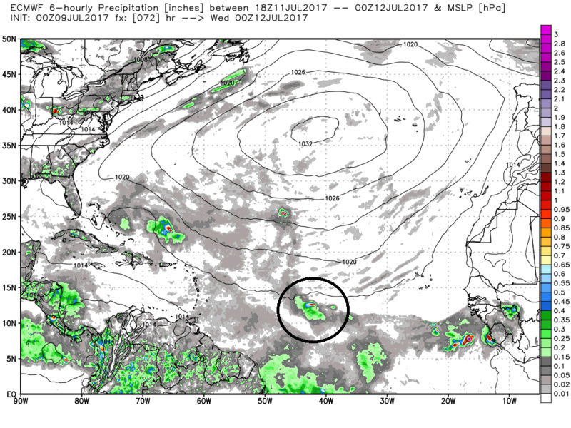
Ok so we have large scale atmospheric conditions that tend to favor rising air in the tropical Pacific. This doesn't mean that at any given time the smaller scale conditions will be right. Lets look at a few more locally environmental/atmospheric conditions with respect to the trop wave(s) in question. As you can see by the MSLP map below by 00z Wed July12th the wave has made it to about 40-45west Longitude on both models. The GFS has this wave as a more closed and organizing system; whereas, the Euro keeps it as an open wave with the thunderstorm activity disorganized.
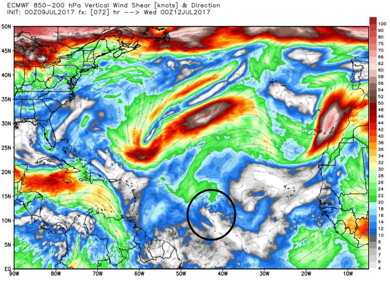
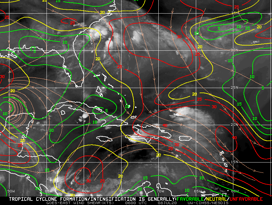
Looking at the shear maps for this same time frame one can see that both models have fairly low shear throughout the MDR region, but there is a huge difference between the two models by 00z July 12th. The GFS has a fairly organized region of anticyclonic activity in the upper levels over top of the trop wave by this time frame. Anticyclone(clockwise winds) in the upper levels acts as an exhaust if you will enhancing lower level convergence which supports additional organization. If the air above a system moves away from itself then the air beneath it is forced to rise to replace it. The euro however has no such organized anticyclonic activity. Thee is some weak anticyclonic organization at best.

The last parameter I will look at is the relative humidity(RH) at the mid levels. Specifically 700mb. As you can clearly see the environment on the GFS is much more moisture laden when compared to the Euro. On the Euro 700mb RH map you can plainly see much more mixing in of the dry air into the area between 40-45West Longitude. This dry air mixing limits the ability for thunderstorm activity and prevents organization to the trop system.

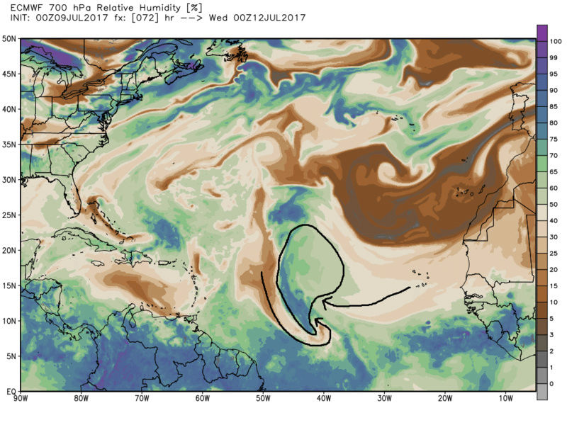
Recall this sentence in the post from Friday: "As long as the wave isn't too fast to catch the dry air out ahead it should have decent conditions to work with once out over the open waters of the MDR(main development region)." If I had to guess the Euro is likely going to win out as the lead wave will likely be consistently infiltrated by dry air mixing in at the mid levels preventing its organization to the lead wave, but recall this image from above:
The second wave seems to be more protected from the dry air so maybe this is infact the wave the GFS is trying to key in on whereas the Euro cont to key in on the first one. We shall see over the next couple of days. Then we re-evaluate all prev mentioned conditions for the next 3days.
_________________
"In weather and in life, there's no winning and losing; there's only winning and learning."
WINTER 2012/2013 TOTALS 43.65"WINTER 2017/2018 TOTALS 62.85" WINTER 2022/2023 TOTALS 4.9"
WINTER 2013/2014 TOTALS 64.85"WINTER 2018/2019 TOTALS 14.25" WINTER 2023/2024 TOTALS 13.1"
WINTER 2014/2015 TOTALS 71.20"WINTER 2019/2020 TOTALS 6.35"
WINTER 2015/2016 TOTALS 35.00"WINTER 2020/2021 TOTALS 37.75"
WINTER 2016/2017 TOTALS 42.25"WINTER 2021/2022 TOTALS 31.65"
sroc4- Admin
- Posts : 8331
Reputation : 301
Join date : 2013-01-07
Location : Wading River, LI
Re: 2017 General Tropical Cyclone Discussion Thread
![]() by weatherwatchermom Sun Jul 09, 2017 2:09 pm
by weatherwatchermom Sun Jul 09, 2017 2:09 pm
weatherwatchermom- Senior Enthusiast
- Posts : 3733
Reputation : 77
Join date : 2014-11-25
Age : 60
Location : Hazlet Township, NJ
Re: 2017 General Tropical Cyclone Discussion Thread
![]() by jmanley32 Sun Jul 09, 2017 7:20 pm
by jmanley32 Sun Jul 09, 2017 7:20 pm
jmanley32- Senior Enthusiast
- Posts : 20513
Reputation : 108
Join date : 2013-12-12
Age : 42
Location : Yonkers, NY
Re: 2017 General Tropical Cyclone Discussion Thread
![]() by jmanley32 Sun Jul 09, 2017 7:43 pm
by jmanley32 Sun Jul 09, 2017 7:43 pm
jmanley32- Senior Enthusiast
- Posts : 20513
Reputation : 108
Join date : 2013-12-12
Age : 42
Location : Yonkers, NY
Re: 2017 General Tropical Cyclone Discussion Thread
![]() by Snow88 Mon Jul 10, 2017 12:45 am
by Snow88 Mon Jul 10, 2017 12:45 am
Snow88- Senior Enthusiast
- Posts : 2193
Reputation : 4
Join date : 2013-01-09
Age : 35
Location : Brooklyn, NY
Re: 2017 General Tropical Cyclone Discussion Thread
![]() by sroc4 Mon Jul 10, 2017 7:05 am
by sroc4 Mon Jul 10, 2017 7:05 am
_________________
"In weather and in life, there's no winning and losing; there's only winning and learning."
WINTER 2012/2013 TOTALS 43.65"WINTER 2017/2018 TOTALS 62.85" WINTER 2022/2023 TOTALS 4.9"
WINTER 2013/2014 TOTALS 64.85"WINTER 2018/2019 TOTALS 14.25" WINTER 2023/2024 TOTALS 13.1"
WINTER 2014/2015 TOTALS 71.20"WINTER 2019/2020 TOTALS 6.35"
WINTER 2015/2016 TOTALS 35.00"WINTER 2020/2021 TOTALS 37.75"
WINTER 2016/2017 TOTALS 42.25"WINTER 2021/2022 TOTALS 31.65"
sroc4- Admin
- Posts : 8331
Reputation : 301
Join date : 2013-01-07
Location : Wading River, LI
Re: 2017 General Tropical Cyclone Discussion Thread
![]() by jmanley32 Mon Jul 10, 2017 10:47 am
by jmanley32 Mon Jul 10, 2017 10:47 am
well the gfs has no other support and euro does so that could very well bbtrue. Now gfs is on a go track. Isn't euro overall better with tropics anyways? Certainly nailed Sandy smoung others.sroc4 wrote:The Euro will likely lead the way on this one. At least that's the way it looks now.
jmanley32- Senior Enthusiast
- Posts : 20513
Reputation : 108
Join date : 2013-12-12
Age : 42
Location : Yonkers, NY
Re: 2017 General Tropical Cyclone Discussion Thread
![]() by jmanley32 Mon Jul 10, 2017 4:09 pm
by jmanley32 Mon Jul 10, 2017 4:09 pm
jmanley32- Senior Enthusiast
- Posts : 20513
Reputation : 108
Join date : 2013-12-12
Age : 42
Location : Yonkers, NY
Re: 2017 General Tropical Cyclone Discussion Thread
![]() by sroc4 Mon Jul 10, 2017 6:12 pm
by sroc4 Mon Jul 10, 2017 6:12 pm
jmanley32 wrote:People on other chats seem to feel x t 4 might become something. It's def not gone but nhc doesn't think so.
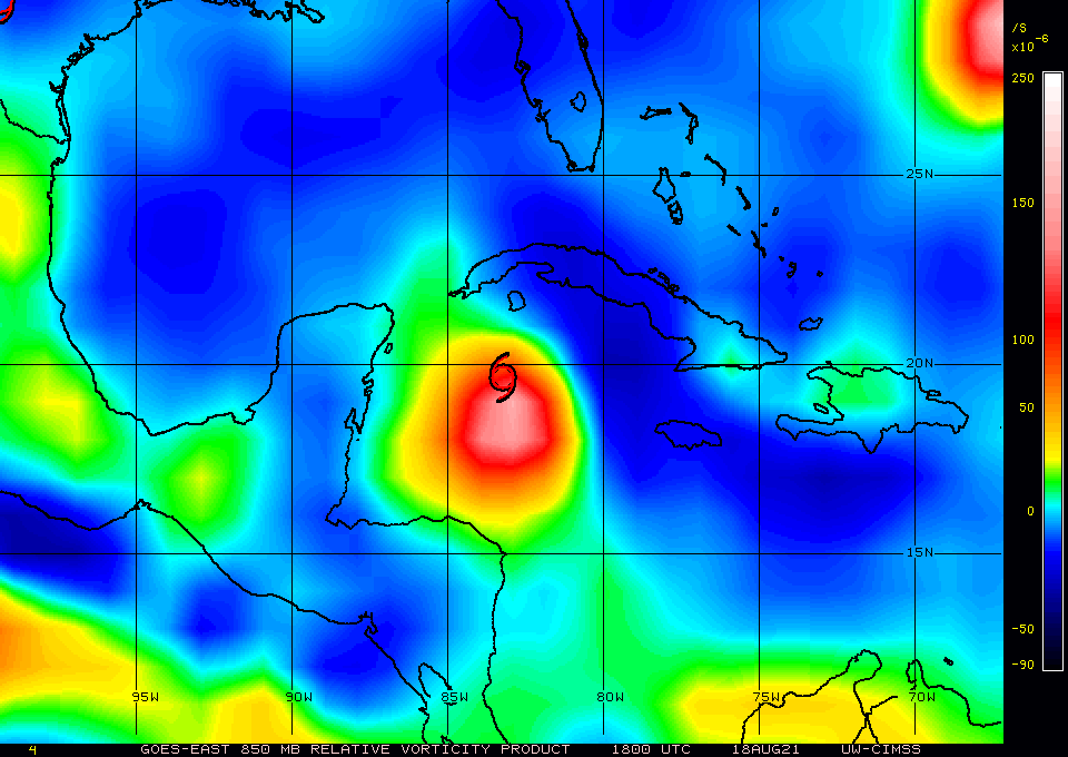
I doubt it. Although there is decent upper level divergence and low level convergence the ULL spinning to its north is creating a significant amount of shear in the N and NW quadrants. In addition it may be ingesting dry air from the west. The vorticity is very spread out and not focused at all. Maybe if it gets into the GOM it may have a chance.


_________________
"In weather and in life, there's no winning and losing; there's only winning and learning."
WINTER 2012/2013 TOTALS 43.65"WINTER 2017/2018 TOTALS 62.85" WINTER 2022/2023 TOTALS 4.9"
WINTER 2013/2014 TOTALS 64.85"WINTER 2018/2019 TOTALS 14.25" WINTER 2023/2024 TOTALS 13.1"
WINTER 2014/2015 TOTALS 71.20"WINTER 2019/2020 TOTALS 6.35"
WINTER 2015/2016 TOTALS 35.00"WINTER 2020/2021 TOTALS 37.75"
WINTER 2016/2017 TOTALS 42.25"WINTER 2021/2022 TOTALS 31.65"
sroc4- Admin
- Posts : 8331
Reputation : 301
Join date : 2013-01-07
Location : Wading River, LI
Re: 2017 General Tropical Cyclone Discussion Thread
![]() by jmanley32 Mon Jul 10, 2017 9:40 pm
by jmanley32 Mon Jul 10, 2017 9:40 pm
jmanley32- Senior Enthusiast
- Posts : 20513
Reputation : 108
Join date : 2013-12-12
Age : 42
Location : Yonkers, NY
Page 2 of 40 • 1, 2, 3 ... 21 ... 40 ![]()
|
|
|