
 Search
2017-18 Winter Discussion thread
Page 4 of 6 •  1, 2, 3, 4, 5, 6
 ![]()
Re: 2017-18 Winter Discussion thread
![]() by amugs Fri Oct 13, 2017 7:38 am
by amugs Fri Oct 13, 2017 7:38 am
rb924119 wrote:As we've seen every winter season in my working memory, should be taken with hesitation (just as a warning, my memory is horrible lmao) models do tend to rush the true pattern changes. While it looks good now, I think what we see now for day ten and beyond will ultimately be transient, as much as I hate to admit.
Pattern is going more towards normal as we moved beyond next weekend from the looks as of now of course. Of course we will be transient to a degree as we try to shake out all of this tropical air that these beasts have transported up this way fro the last 6-7 weeks and we have a pig belly trough stuck up in teh GOA.
Reasons why what I showed back in the beginning of OCtober for a mid month change to more normal and the trough sticking aorund in teh NE as we had this past summer was the hcane brigade which could be directly related to the MJO phase 2, Nina state in the EPAC, Low shear and boiling Hotlantic and the SOI going to SD 9 which is way AN from its normal range. As does with weather it takes time to shake things out so to speak. A recurving typhoon will help but the pig eyed AL LP looks to be pulling back.
Also my and everyone else's favorite - solar, the sun that is - was VERY active during the stretch as well but has since calmed down to nill which will help with HL blocking over teh top.
Time will tell and I am sure a Zito curve ball from his prime will be thrown into teh mix!
amugs- Advanced Forecaster - Mod

- Posts : 15095
Join date : 2013-01-07
Re: 2017-18 Winter Discussion thread
![]() by algae888 Sat Oct 14, 2017 6:45 pm
by algae888 Sat Oct 14, 2017 6:45 pm


if enso doesn't cool drastically the next few weeks esp nino 3.4 and 4 we are looking at a muted enso and pdo (which warmed in September but now cooling) both of which will have less impact on our sensible weather and allow other factors like the strat soi mjo to name a few to have more influence on our weather. throw in the very warm waters in the north atlantic which could help with the nao domain, lead me to believe that we could be in for a nice winter if you like cold and snow. right now I see no glaring issues unless of course nina gets to moderate or the pdo tanks. nina winters usually start early (front loaded) so get ready for the ride people.
algae888- Advanced Forecaster

- Posts : 5311
Join date : 2013-02-05
Re: 2017-18 Winter Discussion thread
![]() by algae888 Sat Oct 14, 2017 6:53 pm
by algae888 Sat Oct 14, 2017 6:53 pm


algae888- Advanced Forecaster
- Posts : 5311
Reputation : 46
Join date : 2013-02-05
Age : 62
Location : mt. vernon, new york
Re: 2017-18 Winter Discussion thread
![]() by amugs Sat Oct 14, 2017 7:34 pm
by amugs Sat Oct 14, 2017 7:34 pm
Solar is muted now too after a fury for a good 4 weeks. No flares or coronal holes ejected it's solar stream towards us.
Okay anyone checking out we have had 3 volcanoes erupt and 3 eq in the last two weeks?? Agnung stillmpercolating along with Campo in Italia.
_________________
Mugs
AKA:King: Snow Weenie
Self Proclaimed
WINTER 2014-15 : 55.12" +.02 for 6 coatings (avg. 35")
WINTER 2015-16 Total - 29.8" (Avg 35")
WINTER 2016-17 : 39.5" so far

amugs- Advanced Forecaster - Mod
- Posts : 15095
Reputation : 213
Join date : 2013-01-07
Age : 54
Location : Hillsdale,NJ
Re: 2017-18 Winter Discussion thread
![]() by Frank_Wx Mon Oct 16, 2017 7:54 am
by Frank_Wx Mon Oct 16, 2017 7:54 am

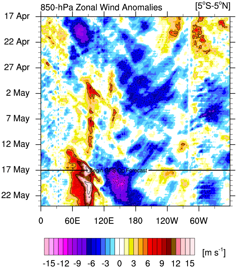
This is probably the most classic La Nina look I've seen in awhile with regards to mean zonal winds.
_________________
_______________________________________________________________________________________________________
CLICK HERE to view NJ Strong Snowstorm Classifications

Frank_Wx- Godzilla Seeker

- Posts : 21305
Reputation : 328
Join date : 2013-01-05
Age : 32
Location : Jersey City, NJ -

Re: 2017-18 Winter Discussion thread
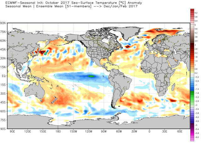
![]() by amugs Mon Oct 16, 2017 8:53 am
by amugs Mon Oct 16, 2017 8:53 am
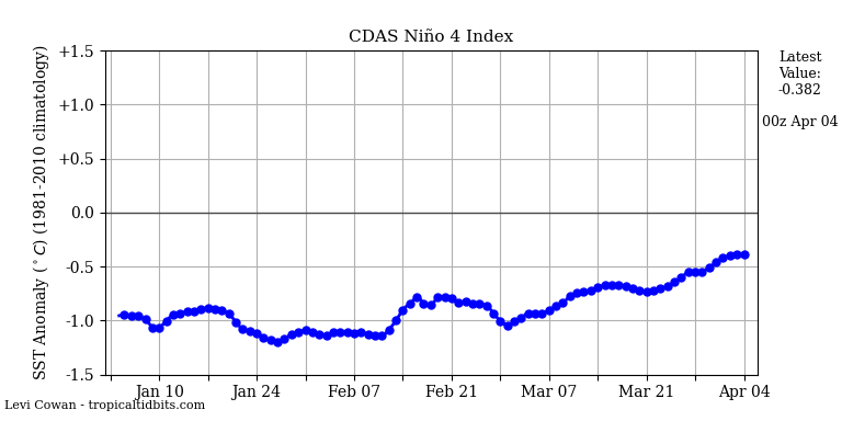
PDO is going N by that SST map
_________________
Mugs
AKA:King: Snow Weenie
Self Proclaimed
WINTER 2014-15 : 55.12" +.02 for 6 coatings (avg. 35")
WINTER 2015-16 Total - 29.8" (Avg 35")
WINTER 2016-17 : 39.5" so far
amugs- Advanced Forecaster - Mod
- Posts : 15095
Reputation : 213
Join date : 2013-01-07
Age : 54
Location : Hillsdale,NJ
Re: 2017-18 Winter Discussion thread
![]() by amugs Mon Oct 16, 2017 8:59 pm
by amugs Mon Oct 16, 2017 8:59 pm

_________________
Mugs
AKA:King: Snow Weenie
Self Proclaimed
WINTER 2014-15 : 55.12" +.02 for 6 coatings (avg. 35")
WINTER 2015-16 Total - 29.8" (Avg 35")
WINTER 2016-17 : 39.5" so far
amugs- Advanced Forecaster - Mod
- Posts : 15095
Reputation : 213
Join date : 2013-01-07
Age : 54
Location : Hillsdale,NJ
Re: 2017-18 Winter Discussion thread
![]() by jmanley32 Mon Oct 16, 2017 9:23 pm
by jmanley32 Mon Oct 16, 2017 9:23 pm
https://www.weather.gov/crh/hazsimplification

jmanley32- Senior Enthusiast

- Posts : 20535
Reputation : 108
Join date : 2013-12-12
Age : 43
Location : Yonkers, NY
Re: 2017-18 Winter Discussion thread
![]() by sroc4 Wed Oct 18, 2017 6:42 am
by sroc4 Wed Oct 18, 2017 6:42 am


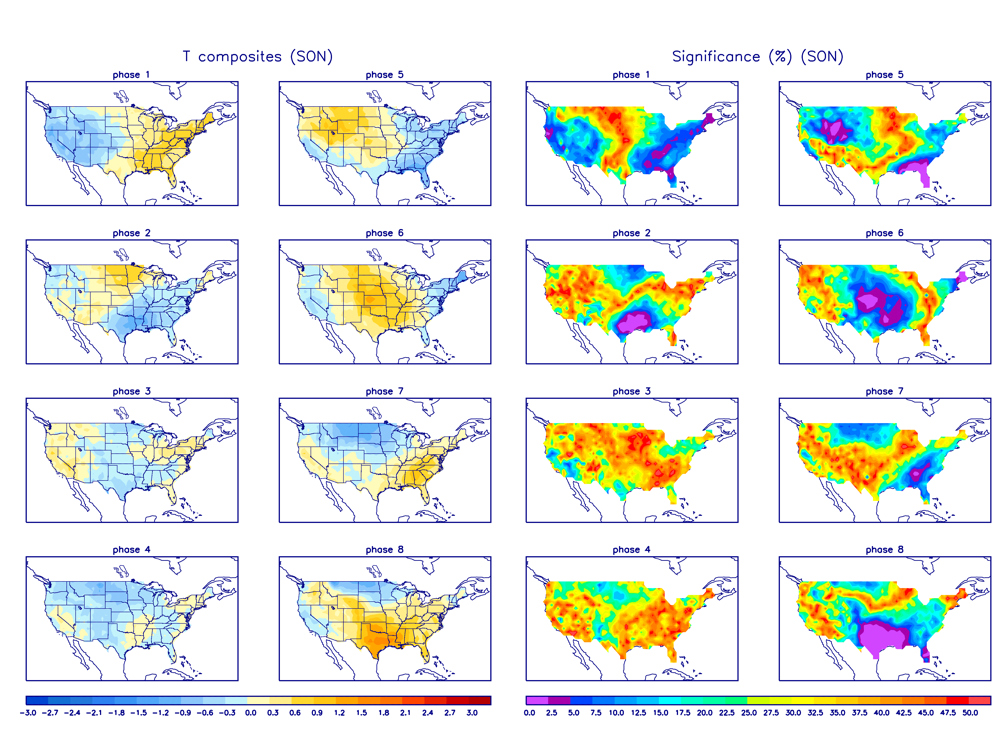
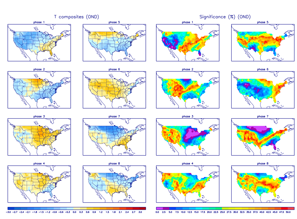
Beyond that we will have to see. Some hints at a piece of the mean trough near the Aleutians will break off and dropping south towards the west coast which would bring us back to higher heights overall in the east (La Nina like base state). As of now that is our main driver(neutral to La Nina like pattern, "base state"= when other pattern enhancers are not at play, but the MJO is strongly pulsing and forecasted to propagate strongly through phases 5-7 before possibly crashing back into the COD. We will see how the MJO forecasts play out as well as the MJO wave is def something that will affect the big picture in likely a transient way if it goes back into the COD.


You can see for yourself what the MJO temp composites look like for phases 5, 6, and 7. You can also see they are a little different depending on if your looking at the avg composite for Sept/Oct/Nov vs Oct/Nov/Dec
By the weekend, out ahead of the cold shot mentioned above into the east this will be the look, very Nina like, trough west ridge east.

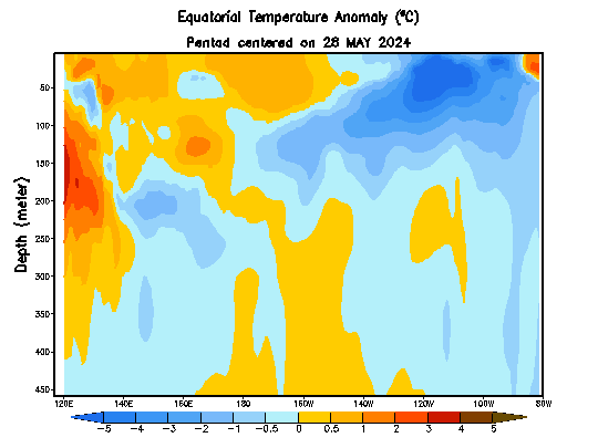
All Nina regions cont the trend towards weak La Nina, now even Nina region 4 is taking the nose dive. The SOI index conts to blow with strong easterly's across the trop Pac. Franks 850mb wind anomaly map he posted a day or so ago shows the results of the persistent SOI in the mod-strong positive nicely. And as stated prev the overall temp changes in the trop Pac should cont to slowly trend colder with potential for transient temp increases, but over all trends towards cooler anomalies. Exactly how long and how strong the cooler anomaly's will trend we shall see.
_________________
"In weather and in life, there's no winning and losing; there's only winning and learning."
WINTER 2012/2013 TOTALS 43.65"WINTER 2017/2018 TOTALS 62.85" WINTER 2022/2023 TOTALS 4.9"
WINTER 2013/2014 TOTALS 64.85"WINTER 2018/2019 TOTALS 14.25" WINTER 2023/2024 TOTALS 13.1"
WINTER 2014/2015 TOTALS 71.20"WINTER 2019/2020 TOTALS 6.35"
WINTER 2015/2016 TOTALS 35.00"WINTER 2020/2021 TOTALS 37.75"
WINTER 2016/2017 TOTALS 42.25"WINTER 2021/2022 TOTALS 31.65"

sroc4- Admin
- Posts : 8354
Reputation : 302
Join date : 2013-01-07
Location : Wading River, LI
Re: 2017-18 Winter Discussion thread
![]() by sroc4 Wed Oct 18, 2017 7:33 am
by sroc4 Wed Oct 18, 2017 7:33 am
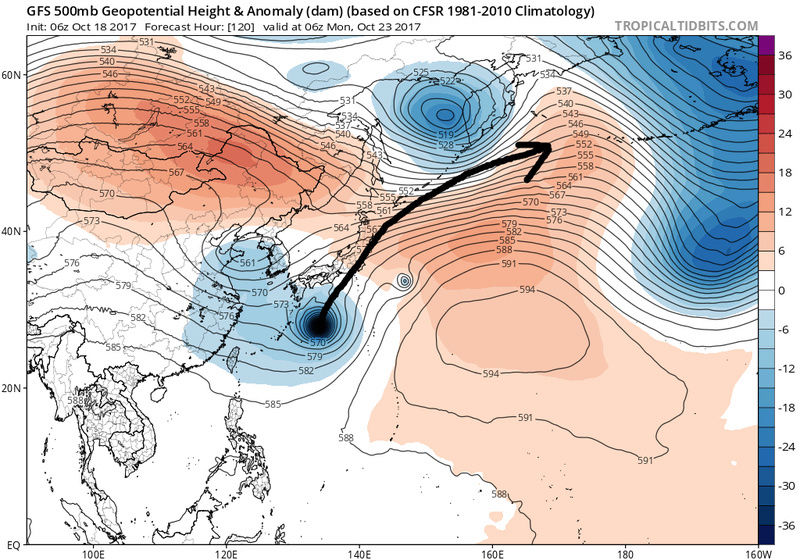
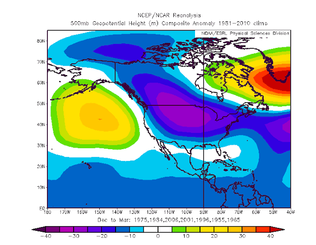
I keep referring to the "base state". Like I mentioned above without any other big picture pattern driver/enhancer the Tropical Pacific is one of the most influential pieces to the puzzle of how the N Hemisphere's overall pattern plays out, esp N America as it is the first landmass down stream. This time of year climatology is such that the cold air masses are still not that cold relatively speaking. Relative to say late Jan where when a piece of polar or arctic air breaks off and descends into the lower latitudes over N Amer, its over all effects/affects on the pattern would be different then the effects/affects this time of year. What I mean by that is this. If you look below at the global SST anomalies you will see that the weak La Nina to neutral trop Pac combined with the warm SST Anomalies in the western Atlantic support a mean trough in the west and Ridge in the east. BUT if we took this exact SST configuration into late Jan the intensity of the eastern ridge will likely be muted by the much colder air in Canada, relative to now, because remember cold air is much more dense than warm air and would not be pushed back so easily. So when the ridge goes back up in Jan, all things being equal, the higher heights would likely not extend quite as far N as we see them on this image.
And so this is what I'm looking at for our upcoming winter. The stronger the Nina, the stronger the "Base State" of trough west, ridge east configuration will be. The stronger the base state the harder it will be for other pattern drivers/enhancers to overcome the base state with any real "staying power". This does not mean that we cannot have periods of troughing in the east with colder anomalies and chances for snow of course. We have a -QBO which statistically increases our odds at stratospheric warming events throughout our winter which will hopefully fight against the base state if favorably positioned warming events take place. We have a Siberian snow growth that is normal to above normal which also statistically favors enhancments to strat warming events and a -AO which increases odds for cold air intrusions into the mid latitudes of NA. MJO waves will also be a wild card that may either fight the base state OR enhance the base state depending on the phase. If we get phases 4-6 in the Dec through Feb time frame we will torch the entire winter as these phases will enhance the La nina Base state. A fear I have is that even with a weak La Nina or technically even Neutral Trop Pac that the strength of the warm SST Anomalies in the western Atlantic right now will allow the SE ridge to flex unfavorably into the NE every time these other pattern enhancers are in flux or aren't as strong. A scary proposition I know. I dont even like discussing it but when looking at the big picture it has to be recognized.
_________________
"In weather and in life, there's no winning and losing; there's only winning and learning."
WINTER 2012/2013 TOTALS 43.65"WINTER 2017/2018 TOTALS 62.85" WINTER 2022/2023 TOTALS 4.9"
WINTER 2013/2014 TOTALS 64.85"WINTER 2018/2019 TOTALS 14.25" WINTER 2023/2024 TOTALS 13.1"
WINTER 2014/2015 TOTALS 71.20"WINTER 2019/2020 TOTALS 6.35"
WINTER 2015/2016 TOTALS 35.00"WINTER 2020/2021 TOTALS 37.75"
WINTER 2016/2017 TOTALS 42.25"WINTER 2021/2022 TOTALS 31.65"
sroc4- Admin
- Posts : 8354
Reputation : 302
Join date : 2013-01-07
Location : Wading River, LI
Re: 2017-18 Winter Discussion thread
![]() by algae888 Wed Oct 18, 2017 9:10 am
by algae888 Wed Oct 18, 2017 9:10 am
these guys are pretty good forecasters. this is there latest outlook for this winter.
here is their composite for winter 2017-18...
they are only using weak nina's for analogs as they feel that if the nina gets moderate it will be to late to affect our winter. I agree esp first half of winter. where can I sign for this!
algae888- Advanced Forecaster
- Posts : 5311
Reputation : 46
Join date : 2013-02-05
Age : 62
Location : mt. vernon, new york
Re: 2017-18 Winter Discussion thread
![]() by jmanley32 Wed Oct 18, 2017 12:57 pm
by jmanley32 Wed Oct 18, 2017 12:57 pm
jmanley32- Senior Enthusiast
- Posts : 20535
Reputation : 108
Join date : 2013-12-12
Age : 43
Location : Yonkers, NY
Re: 2017-18 Winter Discussion thread
![]() by amugs Wed Oct 18, 2017 4:23 pm
by amugs Wed Oct 18, 2017 4:23 pm
algae888 wrote:http://easternmassweather.blogspot.com/2017/10/autumn-chill-ensues-as-enso-begins-to.html
these guys are pretty good forecasters. this is there latest outlook for this winter.
here is their composite for winter 2017-18...
they are only using weak nina's for analogs as they feel that if the nina gets moderate it will be to late to affect our winter. I agree esp first half of winter. where can I sign for this!
He is very good with his predictions and I'll sign below you on this one !
_________________
Mugs
AKA:King: Snow Weenie
Self Proclaimed
WINTER 2014-15 : 55.12" +.02 for 6 coatings (avg. 35")
WINTER 2015-16 Total - 29.8" (Avg 35")
WINTER 2016-17 : 39.5" so far
amugs- Advanced Forecaster - Mod
- Posts : 15095
Reputation : 213
Join date : 2013-01-07
Age : 54
Location : Hillsdale,NJ
Re: 2017-18 Winter Discussion thread
![]() by algae888 Wed Oct 18, 2017 4:24 pm
by algae888 Wed Oct 18, 2017 4:24 pm


algae888- Advanced Forecaster
- Posts : 5311
Reputation : 46
Join date : 2013-02-05
Age : 62
Location : mt. vernon, new york
Re: 2017-18 Winter Discussion thread
![]() by algae888 Wed Oct 18, 2017 4:31 pm
by algae888 Wed Oct 18, 2017 4:31 pm
yes mugs he is good and I feel we will need blocking this winter to offset the WAR. I like how blocking or ridges are starting to show up on guidance as we head towards November....amugs wrote:algae888 wrote:http://easternmassweather.blogspot.com/2017/10/autumn-chill-ensues-as-enso-begins-to.html
these guys are pretty good forecasters. this is there latest outlook for this winter.
here is their composite for winter 2017-18...
they are only using weak nina's for analogs as they feel that if the nina gets moderate it will be to late to affect our winter. I agree esp first half of winter. where can I sign for this!
He is very good with his predictions and I'll sign below you on this one !

euro

ensembles

gfs has trended weaker and east with higher heights near Greenland. let's see which model is correct come October 28th.
algae888- Advanced Forecaster
- Posts : 5311
Reputation : 46
Join date : 2013-02-05
Age : 62
Location : mt. vernon, new york
Re: 2017-18 Winter Discussion thread
![]() by sroc4 Thu Oct 19, 2017 7:14 am
by sroc4 Thu Oct 19, 2017 7:14 am
algae888 wrote:http://easternmassweather.blogspot.com/2017/10/autumn-chill-ensues-as-enso-begins-to.html
these guys are pretty good forecasters. this is there latest outlook for this winter.
here is their composite for winter 2017-18...
they are only using weak nina's for analogs as they feel that if the nina gets moderate it will be to late to affect our winter. I agree esp first half of winter. where can I sign for this!
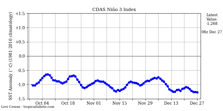
There is no doubt I would sign too, but man this seems to be a bit premature on some of the discussion. For instance: This week, region 3.4 has actually warmed from an anomaly of -.05 Celcius to -.03. This is crucial because time was already of the essence as it relates to the ultimate peak intensity of this burgeoning la nina as winter ensues.
Well lets look now:
Then there is this comment: the warmest JAS ONI reading of any moderate la nina was -.07C, a full .6C warmer than the 2017 reading of -.01. It is with this in mind that we are effectively withdrawing all moderate la nina analogs from consideration.
I know we look for coorolations with diff things and try and relate it to something else, but I'm not sure I see any true significance to the fact that the ONI is not at -0.7 by Sept. I mean I get what they are saying as far as trying to say that if its not here by now it will take to long for the atmosphere to respond even if the numbers cont to drop, but my response to this statement is this:
1) For every emerging La Nina, weak Mod or strong, I averaged the change in the ONI value from the last time it was in neutral territory(+0.4 to -0.4) and the first month it came in in Nina territory(less than or equal to -0.5). For example as they point out as of Sept 2017 the ONI is -0.1(neutral). If Oct ONI comes in at -0.5(La Nina) then I took the change of 0.4 and averaged it with the change from every emerging La Nina year as it went from neutral to La Nina. ON avg when an emerging La Nina is coming the ONI drops about 0.37 or (0.4 rounded) when going from official neutral to the start of official Nina. That said if Oct's numbers follows that trend then it's ONI should be right at -0.5. Now the largest change I found was a drop of 0.7,from -0.1 to -0.8 in one month in 98-99. What I can tell you with high confidence, but not 100% certainty is that this year Oct's ONI will come in close to that given the changes that have occurred this month putting this years ONI close to the same value as 98-99 around -0.8. http://origin.cpc.ncep.noaa.gov/products/analysis_monitoring/ensostuff/ONI_v5.php
2) We have to remember that even though we had a brief stint in the spring where a weak El Nino may emerge, we are actually still coming off a weak La Nina winter. The atmosphere has been primed since last winter and late summer and now fall to behave in a La Nina fashion. We have had neg neutral to weak La Nina conditions overall throughout this time frame. In addition almost all strong and very strong El Nino's were followed by at least a moderate La Nina reflexively. Look at the La Nina following 82-83 as a prime example of how it just barley reached mod La Nina in 83-84; then came back toward neutral, then followed up with barely mod La Nina again in 84-85 yet these guys removed these two years from their analogues simply because they were mod La Ninas even though the were weakly mod and both of those years were also -QBO too.
Even if officially we don't reach a Mod La Nina by the strictest of definitions if other pattern drivers and or enhancers do not play their part I fear the winter will not look anything like what these guys are currently using as their analogue package at 500mb. Again this is not to say that we wont have our cold shots and snow chances, but at least for now I am still worried that the avg 500mb map of the mean troughs and ridges from Dec through March will have more ridging in the SE and the center of that mean trough will be further west. AS OF NOW

This is why IMO it is foolish in early Oct to try and put out a winter forecast.
_________________
"In weather and in life, there's no winning and losing; there's only winning and learning."
WINTER 2012/2013 TOTALS 43.65"WINTER 2017/2018 TOTALS 62.85" WINTER 2022/2023 TOTALS 4.9"
WINTER 2013/2014 TOTALS 64.85"WINTER 2018/2019 TOTALS 14.25" WINTER 2023/2024 TOTALS 13.1"
WINTER 2014/2015 TOTALS 71.20"WINTER 2019/2020 TOTALS 6.35"
WINTER 2015/2016 TOTALS 35.00"WINTER 2020/2021 TOTALS 37.75"
WINTER 2016/2017 TOTALS 42.25"WINTER 2021/2022 TOTALS 31.65"
sroc4- Admin
- Posts : 8354
Reputation : 302
Join date : 2013-01-07
Location : Wading River, LI
Re: 2017-18 Winter Discussion thread
![]() by algae888 Thu Oct 19, 2017 7:50 am
by algae888 Thu Oct 19, 2017 7:50 am
algae888- Advanced Forecaster
- Posts : 5311
Reputation : 46
Join date : 2013-02-05
Age : 62
Location : mt. vernon, new york
Re: 2017-18 Winter Discussion thread
![]() by sroc4 Thu Oct 19, 2017 9:04 am
by sroc4 Thu Oct 19, 2017 9:04 am
_________________
"In weather and in life, there's no winning and losing; there's only winning and learning."
WINTER 2012/2013 TOTALS 43.65"WINTER 2017/2018 TOTALS 62.85" WINTER 2022/2023 TOTALS 4.9"
WINTER 2013/2014 TOTALS 64.85"WINTER 2018/2019 TOTALS 14.25" WINTER 2023/2024 TOTALS 13.1"
WINTER 2014/2015 TOTALS 71.20"WINTER 2019/2020 TOTALS 6.35"
WINTER 2015/2016 TOTALS 35.00"WINTER 2020/2021 TOTALS 37.75"
WINTER 2016/2017 TOTALS 42.25"WINTER 2021/2022 TOTALS 31.65"
sroc4- Admin
- Posts : 8354
Reputation : 302
Join date : 2013-01-07
Location : Wading River, LI
Re: 2017-18 Winter Discussion thread
![]() by frank 638 Thu Oct 19, 2017 5:33 pm
by frank 638 Thu Oct 19, 2017 5:33 pm
frank 638- Senior Enthusiast
- Posts : 2843
Reputation : 37
Join date : 2016-01-01
Age : 40
Location : bronx ny
Re: 2017-18 Winter Discussion thread
![]() by frank 638 Thu Oct 19, 2017 5:37 pm
by frank 638 Thu Oct 19, 2017 5:37 pm
frank 638- Senior Enthusiast
- Posts : 2843
Reputation : 37
Join date : 2016-01-01
Age : 40
Location : bronx ny
Re: 2017-18 Winter Discussion thread
![]() by nutleyblizzard Thu Oct 19, 2017 7:19 pm
by nutleyblizzard Thu Oct 19, 2017 7:19 pm
When a weak Nina or Nino is in place, there are other weather drivers that can dictate any given winter. Look back at the winter of 96 for example. We had a weak La Nina in place along with a +PDO and -NAO. We ended up with 78 inches that year. There are other examples where the pattern did not work out in our favor, and we ended up with below average snowfall. With a -QBO and low solar minimum on tap this winter, we should be in good shape as far as blocking is concerned. We'll see what Frank has to say in the coming weeks.frank 638 wrote:My corrections I am sorry what I meant was Lee Goldberg has us for above to slightly above normal for snowfall that's anywhere from 30 to 35 in. And Lonnie Quinn thinks that we will see normal to slightly below normal for snowfall he is thinking anywhere from 25 to 30 in. I hope they are wrong we definitely need a colder and snowy winter to make us snow weenies happy

nutleyblizzard- Senior Enthusiast
- Posts : 1954
Reputation : 41
Join date : 2014-01-30
Age : 58
Location : Nutley, new jersey
Re: 2017-18 Winter Discussion thread
![]() by frank 638 Thu Oct 19, 2017 7:28 pm
by frank 638 Thu Oct 19, 2017 7:28 pm
frank 638- Senior Enthusiast
- Posts : 2843
Reputation : 37
Join date : 2016-01-01
Age : 40
Location : bronx ny
Re: 2017-18 Winter Discussion thread
![]() by amugs Thu Oct 19, 2017 8:57 pm
by amugs Thu Oct 19, 2017 8:57 pm
2017 total: 66 days (23%)
_________________
Mugs
AKA:King: Snow Weenie
Self Proclaimed
WINTER 2014-15 : 55.12" +.02 for 6 coatings (avg. 35")
WINTER 2015-16 Total - 29.8" (Avg 35")
WINTER 2016-17 : 39.5" so far
amugs- Advanced Forecaster - Mod
- Posts : 15095
Reputation : 213
Join date : 2013-01-07
Age : 54
Location : Hillsdale,NJ
Re: 2017-18 Winter Discussion thread
![]() by amugs Thu Oct 19, 2017 9:11 pm
by amugs Thu Oct 19, 2017 9:11 pm
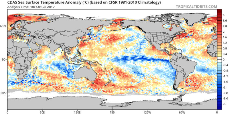
There is a cooler tongue in the central Pacific and we have a more eastward centered cold enso event with the cold pool to the west of Australia. That cold pool keeps the winter MJO out of 4,5,6, the kiss of death by limiting convection. So these are some arguments cold. However overall a weaker version of the very warm stretch of SST from east of the Philippines into the Atlantic
_________________
Mugs
AKA:King: Snow Weenie
Self Proclaimed
WINTER 2014-15 : 55.12" +.02 for 6 coatings (avg. 35")
WINTER 2015-16 Total - 29.8" (Avg 35")
WINTER 2016-17 : 39.5" so far
amugs- Advanced Forecaster - Mod
- Posts : 15095
Reputation : 213
Join date : 2013-01-07
Age : 54
Location : Hillsdale,NJ
Re: 2017-18 Winter Discussion thread
![]() by amugs Thu Oct 19, 2017 9:23 pm
by amugs Thu Oct 19, 2017 9:23 pm
_________________
Mugs
AKA:King: Snow Weenie
Self Proclaimed
WINTER 2014-15 : 55.12" +.02 for 6 coatings (avg. 35")
WINTER 2015-16 Total - 29.8" (Avg 35")
WINTER 2016-17 : 39.5" so far
amugs- Advanced Forecaster - Mod
- Posts : 15095
Reputation : 213
Join date : 2013-01-07
Age : 54
Location : Hillsdale,NJ
Re: 2017-18 Winter Discussion thread
![]() by docstox12 Fri Oct 20, 2017 5:21 am
by docstox12 Fri Oct 20, 2017 5:21 am
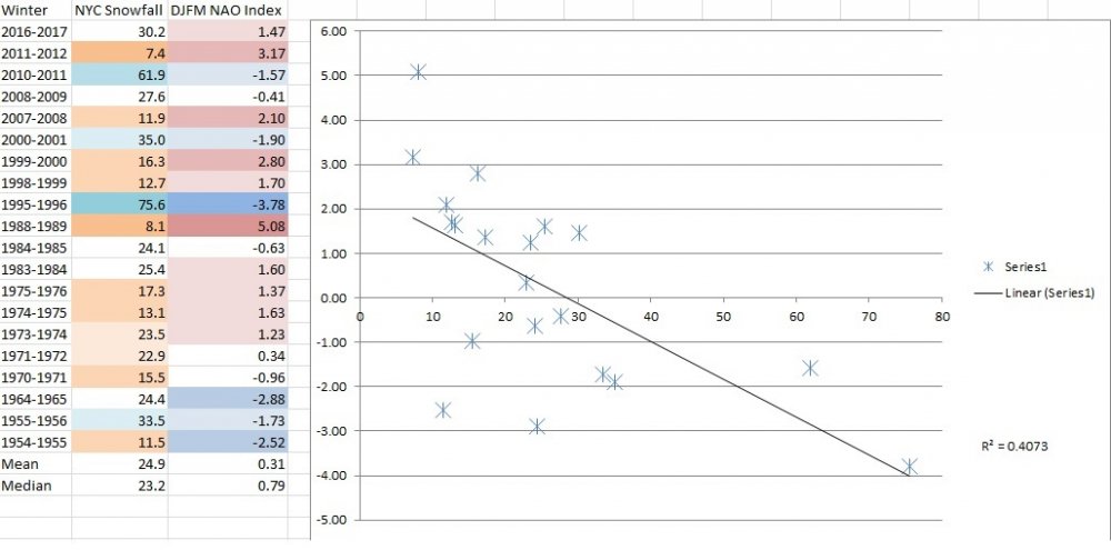
amugs wrote:Here is an interesting graph from a met on another board computation of La Nina and NAO mean average and Snowfall amounts
Mugsy, the only thing I get out of that is the two extremes, '95-96 and '88-'89.Everything else is all over the place.Of course, that's in my opinion FWIW.
Seeing winter forecasts of warmer than normal with normal or a little above average snowfall.Don't mind it milder as long as there is normal or above normal snow.It would probably favor me up here in the HV with the elevation.As Doc says, "you gotta smell the rian to get the heavy snow". Can't even think of winter with this ridiculous October warm spell going on.

docstox12- Wx Statistician Guru

- Posts : 8530
Reputation : 222
Join date : 2013-01-07
Age : 73
Location : Monroe NY
Re: 2017-18 Winter Discussion thread
![]() by Math23x7 Sun Oct 22, 2017 10:53 pm
by Math23x7 Sun Oct 22, 2017 10:53 pm
Math23x7- Wx Statistician Guru
- Posts : 2379
Reputation : 68
Join date : 2013-01-08
Page 4 of 6 • 1, 2, 3, 4, 5, 6 ![]()