
 Search
Tracking Hurricane Irma: Part 2
Page 3 of 21 •  1, 2, 3, 4 ... 12 ... 21
 ![]()
Re: Tracking Hurricane Irma: Part 2
![]() by algae888 Wed Sep 06, 2017 2:31 pm
by algae888 Wed Sep 06, 2017 2:31 pm
and then Hilton head island. double landfall.sroc4 wrote:Miami seems like ground zero today
algae888- Advanced Forecaster

- Posts : 5311
Join date : 2013-02-05


sroc4- Admin

- Posts : 8354
Join date : 2013-01-07
Re: Tracking Hurricane Irma: Part 2
![]() by algae888 Wed Sep 06, 2017 2:40 pm
by algae888 Wed Sep 06, 2017 2:40 pm

algae888- Advanced Forecaster
- Posts : 5311
Reputation : 46
Join date : 2013-02-05
Age : 62
Location : mt. vernon, new york
Re: Tracking Hurricane Irma: Part 2
![]() by Math23x7 Wed Sep 06, 2017 2:44 pm
by Math23x7 Wed Sep 06, 2017 2:44 pm
Fun fact, the ECMWF several days out missed "Juno" (1/26/15) by about the same margin as Sandy (50-100 miles).
Math23x7- Wx Statistician Guru

- Posts : 2379
Reputation : 68
Join date : 2013-01-08
Re: Tracking Hurricane Irma: Part 2
![]() by algae888 Wed Sep 06, 2017 2:48 pm
by algae888 Wed Sep 06, 2017 2:48 pm

it's the reason we have 40 pages on Irma. the good news about Irma and Harvey and the one after Harvey is that it made the last month go by very quickly and we are now much closer to winter!!!
algae888- Advanced Forecaster
- Posts : 5311
Reputation : 46
Join date : 2013-02-05
Age : 62
Location : mt. vernon, new york
Re: Tracking Hurricane Irma: Part 2
![]() by Frank_Wx Wed Sep 06, 2017 2:55 pm
by Frank_Wx Wed Sep 06, 2017 2:55 pm

_________________
_______________________________________________________________________________________________________
CLICK HERE to view NJ Strong Snowstorm Classifications

Frank_Wx- Godzilla Seeker
- Posts : 21305
Reputation : 328
Join date : 2013-01-05
Age : 32
Location : Jersey City, NJ -

Re: Tracking Hurricane Irma: Part 2
![]() by sroc4 Wed Sep 06, 2017 2:56 pm
by sroc4 Wed Sep 06, 2017 2:56 pm
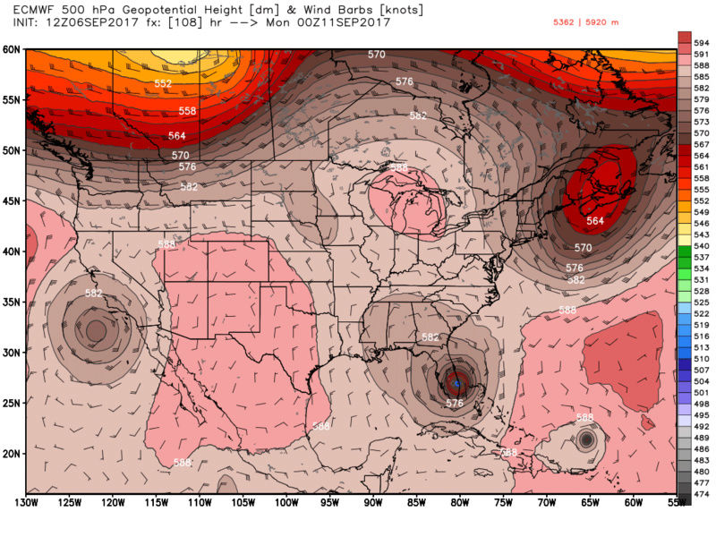
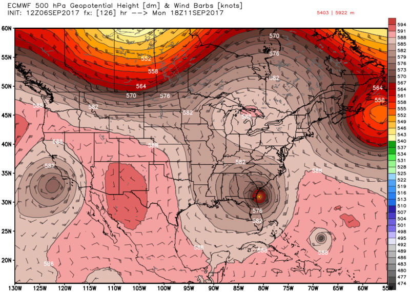
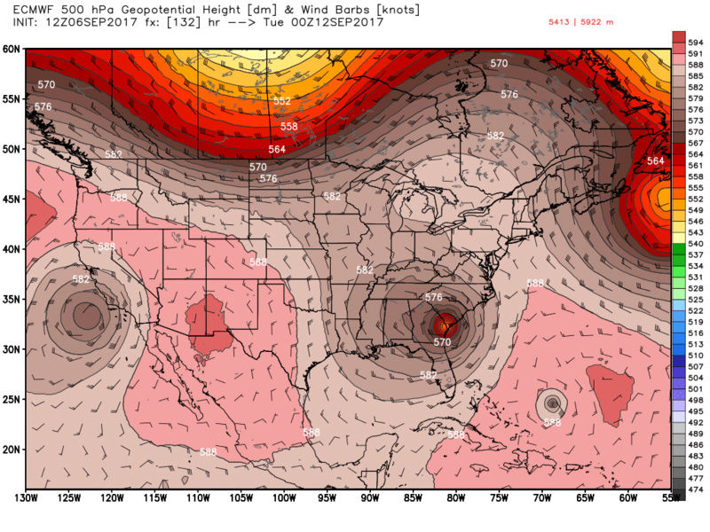
algae888 wrote:scott look how she gets pulled in or merges with the trough dropping in from central Canada. the tough over the n/e if she interacted with it would have likely pushed her out to sea. if the set up shown on those euro maps at hour 96-120 were about 250 miles east she probably makes landfall between outer banks and cape cod. I guess still time for corrections but we need perfect timing and set up (unlike winter storms) to get these animals to make landfall this far north. very rare indeed.
Yes Al. Here is my take. The mean trough will lift out before it has a chance to drag Irma with it. In part due to timing, but also because of the trailing energy you mention that will be grabbing onto her and bring her back to the coast. I've said it for the past day or so, between now and early Friday morning the tug, or lack thereof, from the mean trough will be key to how this all plays out. There is a really good Met on another site that is insistent that it actually gets caught up in the lifting troughs wake and drags her due east at some point. I personally disagree with this at this time, but time will tell.
_________________
"In weather and in life, there's no winning and losing; there's only winning and learning."
WINTER 2012/2013 TOTALS 43.65"WINTER 2017/2018 TOTALS 62.85" WINTER 2022/2023 TOTALS 4.9"
WINTER 2013/2014 TOTALS 64.85"WINTER 2018/2019 TOTALS 14.25" WINTER 2023/2024 TOTALS 13.1"
WINTER 2014/2015 TOTALS 71.20"WINTER 2019/2020 TOTALS 6.35"
WINTER 2015/2016 TOTALS 35.00"WINTER 2020/2021 TOTALS 37.75"
WINTER 2016/2017 TOTALS 42.25"WINTER 2021/2022 TOTALS 31.65"

sroc4- Admin
- Posts : 8354
Reputation : 302
Join date : 2013-01-07
Location : Wading River, LI
Re: Tracking Hurricane Irma: Part 2
![]() by Frank_Wx Wed Sep 06, 2017 2:56 pm
by Frank_Wx Wed Sep 06, 2017 2:56 pm
I really hope this changes. SE Florida would be in ruins if Irma took a path WEST of them.

_________________
_______________________________________________________________________________________________________
CLICK HERE to view NJ Strong Snowstorm Classifications
Frank_Wx- Godzilla Seeker
- Posts : 21305
Reputation : 328
Join date : 2013-01-05
Age : 32
Location : Jersey City, NJ -
Re: Tracking Hurricane Irma: Part 2
![]() by frank 638 Wed Sep 06, 2017 2:57 pm
by frank 638 Wed Sep 06, 2017 2:57 pm
frank 638- Senior Enthusiast

- Posts : 2843
Reputation : 37
Join date : 2016-01-01
Age : 40
Location : bronx ny
Re: Tracking Hurricane Irma: Part 2
![]() by Frank_Wx Wed Sep 06, 2017 3:02 pm
by Frank_Wx Wed Sep 06, 2017 3:02 pm
frank 638 wrote:Hey everyone I hope everybody is good .I have been so busy with work .I was just wondering if Irma will make up here and how strong will she be
A very high chance she stays south of our area. Most we may see is some rain and 20 to 30 mph winds. Essentially nothing.
_________________
_______________________________________________________________________________________________________
CLICK HERE to view NJ Strong Snowstorm Classifications
Frank_Wx- Godzilla Seeker
- Posts : 21305
Reputation : 328
Join date : 2013-01-05
Age : 32
Location : Jersey City, NJ -
Re: Tracking Hurricane Irma: Part 2
![]() by frank 638 Wed Sep 06, 2017 3:03 pm
by frank 638 Wed Sep 06, 2017 3:03 pm
frank 638- Senior Enthusiast
- Posts : 2843
Reputation : 37
Join date : 2016-01-01
Age : 40
Location : bronx ny
Re: Tracking Hurricane Irma: Part 2
![]() by amugs Wed Sep 06, 2017 3:15 pm
by amugs Wed Sep 06, 2017 3:15 pm
Euro is shifting North to GFS track each run.
We still have a ways to go to see what effects she will have up here. IMO we are not out the woods. Not wish casting but just being patient and as I told all of my coworkers, friends and families be on the lookout.
ALL l I can say is WATCH OUT!! SHE IS ANGRY!!

_________________
Mugs
AKA:King: Snow Weenie
Self Proclaimed
WINTER 2014-15 : 55.12" +.02 for 6 coatings (avg. 35")
WINTER 2015-16 Total - 29.8" (Avg 35")
WINTER 2016-17 : 39.5" so far

amugs- Advanced Forecaster - Mod

- Posts : 15095
Reputation : 213
Join date : 2013-01-07
Age : 54
Location : Hillsdale,NJ
Re: Tracking Hurricane Irma: Part 2
![]() by Frank_Wx Wed Sep 06, 2017 3:18 pm
by Frank_Wx Wed Sep 06, 2017 3:18 pm
_________________
_______________________________________________________________________________________________________
CLICK HERE to view NJ Strong Snowstorm Classifications
Frank_Wx- Godzilla Seeker
- Posts : 21305
Reputation : 328
Join date : 2013-01-05
Age : 32
Location : Jersey City, NJ -
Re: Tracking Hurricane Irma: Part 2
![]() by Guest Wed Sep 06, 2017 3:24 pm
by Guest Wed Sep 06, 2017 3:24 pm
If Frank doesn't think we will see any significant impacts I'm going to be done tracking her for awhile. I was at least hoping for some very heavy rains at a minimum.
Guest- Guest
Re: Tracking Hurricane Irma: Part 2
![]() by Guest Wed Sep 06, 2017 3:24 pm
by Guest Wed Sep 06, 2017 3:24 pm
Guest- Guest
Re: Tracking Hurricane Irma: Part 2
![]() by Frank_Wx Wed Sep 06, 2017 3:34 pm
by Frank_Wx Wed Sep 06, 2017 3:34 pm
syosnow94 wrote:Mushy a little more optimistic than a Frankie boy at this stage.
If Frank doesn't think we will see any significant impacts I'm going to be done tracking her for awhile. I was at least hoping for some very heavy rains at a minimum.
The CMC is the only model that brings significant rain to our area from Irma, and even then it's not impressive. We will keep watching but doubt we see much.

TheAresian wrote:TropTid is showing the Euro initializing at 960 mb while the NHC is reporting it in the mid to upper 920. Does that mean we take the TT pressures and adjust 30-35 mbs lower?
These global models have trouble recording pressure due to their resolutions. Stick with what observed data shows (recon) and hi-res models.
_________________
_______________________________________________________________________________________________________
CLICK HERE to view NJ Strong Snowstorm Classifications
Frank_Wx- Godzilla Seeker
- Posts : 21305
Reputation : 328
Join date : 2013-01-05
Age : 32
Location : Jersey City, NJ -
Re: Tracking Hurricane Irma: Part 2
![]() by Guest Wed Sep 06, 2017 3:37 pm
by Guest Wed Sep 06, 2017 3:37 pm
Frank_Wx wrote:syosnow94 wrote:Mushy a little more optimistic than a Frankie boy at this stage.
If Frank doesn't think we will see any significant impacts I'm going to be done tracking her for awhile. I was at least hoping for some very heavy rains at a minimum.
The CMC is the only model that brings significant rain to our area from Irma, and even then it's not impressive. We will keep watching but doubt we see much.TheAresian wrote:TropTid is showing the Euro initializing at 960 mb while the NHC is reporting it in the mid to upper 920. Does that mean we take the TT pressures and adjust 30-35 mbs lower?
These global models have trouble recording pressure due to their resolutions. Stick with what observed data shows (recon) and hi-res models.
Thank you, Frank.
Guest- Guest
Re: Tracking Hurricane Irma: Part 2
![]() by sroc4 Wed Sep 06, 2017 3:41 pm
by sroc4 Wed Sep 06, 2017 3:41 pm

_________________
"In weather and in life, there's no winning and losing; there's only winning and learning."
WINTER 2012/2013 TOTALS 43.65"WINTER 2017/2018 TOTALS 62.85" WINTER 2022/2023 TOTALS 4.9"
WINTER 2013/2014 TOTALS 64.85"WINTER 2018/2019 TOTALS 14.25" WINTER 2023/2024 TOTALS 13.1"
WINTER 2014/2015 TOTALS 71.20"WINTER 2019/2020 TOTALS 6.35"
WINTER 2015/2016 TOTALS 35.00"WINTER 2020/2021 TOTALS 37.75"
WINTER 2016/2017 TOTALS 42.25"WINTER 2021/2022 TOTALS 31.65"
sroc4- Admin
- Posts : 8354
Reputation : 302
Join date : 2013-01-07
Location : Wading River, LI
Re: Tracking Hurricane Irma: Part 2
![]() by amugs Wed Sep 06, 2017 4:06 pm
by amugs Wed Sep 06, 2017 4:06 pm
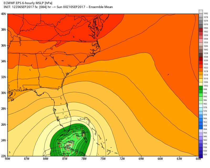
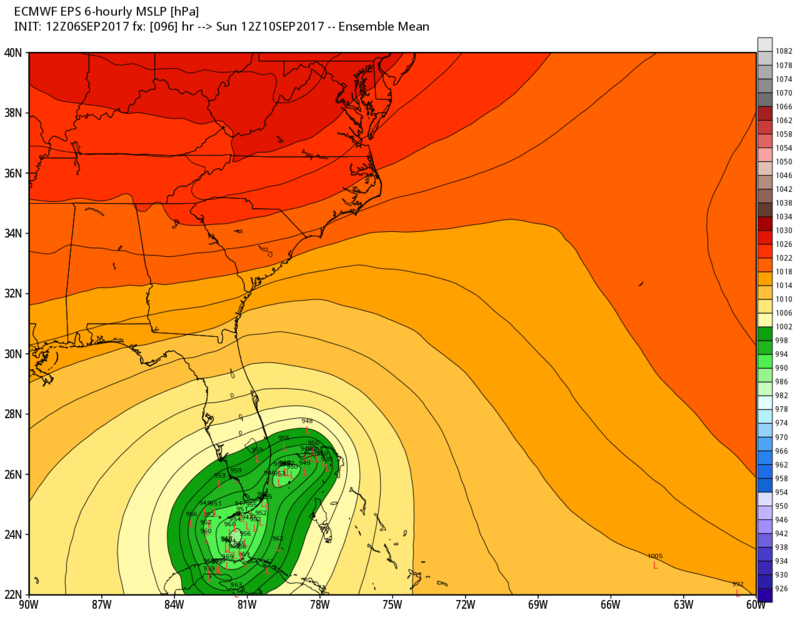
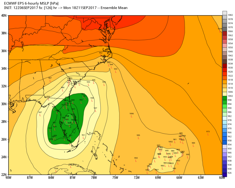
BTW she is filing in on her western flank and should start to strengthen a bit.
EPS Pasta

_________________
Mugs
AKA:King: Snow Weenie
Self Proclaimed
WINTER 2014-15 : 55.12" +.02 for 6 coatings (avg. 35")
WINTER 2015-16 Total - 29.8" (Avg 35")
WINTER 2016-17 : 39.5" so far
amugs- Advanced Forecaster - Mod
- Posts : 15095
Reputation : 213
Join date : 2013-01-07
Age : 54
Location : Hillsdale,NJ
Re: Tracking Hurricane Irma: Part 2
![]() by sroc4 Wed Sep 06, 2017 4:34 pm
by sroc4 Wed Sep 06, 2017 4:34 pm

_________________
"In weather and in life, there's no winning and losing; there's only winning and learning."
WINTER 2012/2013 TOTALS 43.65"WINTER 2017/2018 TOTALS 62.85" WINTER 2022/2023 TOTALS 4.9"
WINTER 2013/2014 TOTALS 64.85"WINTER 2018/2019 TOTALS 14.25" WINTER 2023/2024 TOTALS 13.1"
WINTER 2014/2015 TOTALS 71.20"WINTER 2019/2020 TOTALS 6.35"
WINTER 2015/2016 TOTALS 35.00"WINTER 2020/2021 TOTALS 37.75"
WINTER 2016/2017 TOTALS 42.25"WINTER 2021/2022 TOTALS 31.65"
sroc4- Admin
- Posts : 8354
Reputation : 302
Join date : 2013-01-07
Location : Wading River, LI
Re: Tracking Hurricane Irma: Part 2
![]() by RJB8525 Wed Sep 06, 2017 5:09 pm
by RJB8525 Wed Sep 06, 2017 5:09 pm

RJB8525- Senior Enthusiast
- Posts : 1994
Reputation : 28
Join date : 2013-02-06
Age : 38
Location : Hackettstown, NJ
Re: Tracking Hurricane Irma: Part 2
![]() by Frank_Wx Wed Sep 06, 2017 5:09 pm
by Frank_Wx Wed Sep 06, 2017 5:09 pm

.gif.0f9de32a0a87cfc535462daae196ef17.gif)
_________________
_______________________________________________________________________________________________________
CLICK HERE to view NJ Strong Snowstorm Classifications
Frank_Wx- Godzilla Seeker
- Posts : 21305
Reputation : 328
Join date : 2013-01-05
Age : 32
Location : Jersey City, NJ -
Re: Tracking Hurricane Irma: Part 2
![]() by Frank_Wx Wed Sep 06, 2017 5:11 pm
by Frank_Wx Wed Sep 06, 2017 5:11 pm

_________________
_______________________________________________________________________________________________________
CLICK HERE to view NJ Strong Snowstorm Classifications
Frank_Wx- Godzilla Seeker
- Posts : 21305
Reputation : 328
Join date : 2013-01-05
Age : 32
Location : Jersey City, NJ -
Re: Tracking Hurricane Irma: Part 2
![]() by jmanley32 Wed Sep 06, 2017 5:11 pm
by jmanley32 Wed Sep 06, 2017 5:11 pm
Last edited by jmanley32 on Wed Sep 06, 2017 5:15 pm; edited 1 time in total

jmanley32- Senior Enthusiast
- Posts : 20535
Reputation : 108
Join date : 2013-12-12
Age : 43
Location : Yonkers, NY
Re: Tracking Hurricane Irma: Part 2
![]() by nutleyblizzard Wed Sep 06, 2017 5:13 pm
by nutleyblizzard Wed Sep 06, 2017 5:13 pm

nutleyblizzard- Senior Enthusiast
- Posts : 1954
Reputation : 41
Join date : 2014-01-30
Age : 58
Location : Nutley, new jersey
Re: Tracking Hurricane Irma: Part 2
![]() by jmanley32 Wed Sep 06, 2017 5:14 pm
by jmanley32 Wed Sep 06, 2017 5:14 pm
this may be a dumb question but what leads u to believe mid Atlantic vs Carolinas? Upper pattern? Even if this hit midatlsntic full on we would still get quite a storm if continued north. I know u feel very low chance and ur prolly right but the nam is def not to discount anymore.Frank_Wx wrote:18z NAM uhmmm misses Florida and looks like it wants to head toward Mid Atlantic
jmanley32- Senior Enthusiast
- Posts : 20535
Reputation : 108
Join date : 2013-12-12
Age : 43
Location : Yonkers, NY
Re: Tracking Hurricane Irma: Part 2
![]() by jmanley32 Wed Sep 06, 2017 5:16 pm
by jmanley32 Wed Sep 06, 2017 5:16 pm
frank just posted above your post possibly midatlantic. This is def get interesting!nutleyblizzard wrote:The 18z Nam is east of 12z to the point where it misses Florida completely! Has the storm moving due north. If extrapolated out, landfall would be in the outer banks of NC.
jmanley32- Senior Enthusiast
- Posts : 20535
Reputation : 108
Join date : 2013-12-12
Age : 43
Location : Yonkers, NY
Page 3 of 21 • 1, 2, 3, 4 ... 12 ... 21 ![]()
|
|
|