
 Search
Long Range Thread 15.0
Page 11 of 42 •  1 ... 7 ... 10, 11, 12 ... 26 ... 42
 ![]()
Re: Long Range Thread 15.0
![]() by Math23x7 Sat Nov 25, 2017 3:12 pm
by Math23x7 Sat Nov 25, 2017 3:12 pm
Math23x7- Wx Statistician Guru

- Posts : 2379
Join date : 2013-01-08
Re: Long Range Thread 15.0
![]() by dkodgis Sun Nov 26, 2017 7:13 am
by dkodgis Sun Nov 26, 2017 7:13 am
dkodgis- Senior Enthusiast

- Posts : 2501
Join date : 2013-12-29
Re: Long Range Thread 15.0
![]() by sroc4 Sun Nov 26, 2017 9:13 am
by sroc4 Sun Nov 26, 2017 9:13 am
So if you didn't know any better you may start to get really discouraged by the way it feels outdoors over the next 10-14d assuming you are a cold weather lover. Hopefully the next few minutes will offer some encouragement to those who may begin to panic. Now not every day is going to roast, but overall the temp anomalies are more likely than not going to be Above Normal(AN) in the 10-14. Tonight temps will likely dip to below normal and cont until Tuesday when a warm front will bring us back AN. So we are going to have to get through periods that look like this. When its warm it is going to be WARM. If we get a cool shot it will likely be short lived and only a smidge BN in the 10-14.


Now keep in mind this period was expected and predicted well in advanced, this should come as no surprise. The question is....then what? Well the ensembles, EPS and GEFS alike, are now starting to hint at what may be to come. The time frame to start watching is between Dec 8th-15th. Some may state that it will happen in the first part of the Dec 8th-15th time frame I stated, and that may be true, but as Ive stated before It has been my experience that over the last few years the shift from a warm regime back to cool always seems to be a tad slower than what it may first appear.
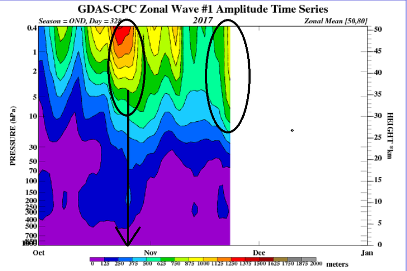
Now as was accurately predicted by Isotherm the wave 1 attack on the strat is under way on the strat once again. I circled the prev noted wave 1 attack we saw at the end of Oct and you can see that this current wave 1 attack has the potential to be even stronger. There are also rumblings of a "possible" follow up wave 2 attack as well.
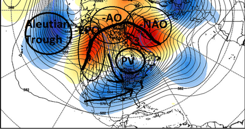
Below are the EPS and the GEFS showing where the pattern potentially is going to as we head into the second week of Dec. Take notice of a few things. First the trough south of the Aleutian Islands. This typically aids in pumping up the ridging into Alaska (-EPO) and down stream leads to a trough in the east. Second is the "Ridge Bridge". Both the GEFS and the EPS are hinting at the -EPO, -AO, -NAO teleconnecting for a true high lat ridge bridge which will force a lobe of the tropospheric PV south towards the Hudson Bay discharging cold air into the eastern half of the CONUS. Folks if this configuration of a -EPO, -AO, -NAO high lat blocking teleconnection comes to fruition the chances of the white gold sky rockets. As indicated by the arrows I have drawn in we may see energy diving into the CONUS riding the polar jet stream interacting with energy via the STJ and systems coming up the coast in a Miller A fashion verbatim of this look. This look is reminicent of an El Nino type pattern, so I would not be surprised to the the SOI spend some time in the neg territorry as we head closer to this time frame. Of course nothing is ever 100%, and there have been times when we have had favorable teleconnections and nothing happens, but this blocking triplet increases our odds exponentially.

My final thoughts will be this. As exciting as this looks in the LR I personally have reservations. We have too many times in the past chased the LR pattern change only to end with disappointments and frustrations with it never coming to fruition as was originally expected. I have been monitoring the strat forecasts as well and a shift to the placement of the strat PV does appear to be headed to the Asian side of the N Hemisphere. But there are details about the position, strength, wind anomaly direction, height anomalies and the "tilt" of the vortex that I do not have the time to write about nor am I fully confident in my ability to explain it correctly in a language that everyone can understand yet. With the shift to the other side of the N Hemi there is some potential for the exciting look that I just discussed to cause all the excitement to be for naught. That said even with a shift I can also see how it still does come to fruition despite the unfavorable centering of the strat PV on the Asian side of the N Hem. Again I am not confident in my ability to explain the reasoning behind that last statement at this time. After it all plays out by looking at the evolution of all theses factors in hind sight hopefully I will be able to put it all together so that we can all understand it for the future.
Have a wonderful Sunday!!
_________________
"In weather and in life, there's no winning and losing; there's only winning and learning."
WINTER 2012/2013 TOTALS 43.65"WINTER 2017/2018 TOTALS 62.85" WINTER 2022/2023 TOTALS 4.9"
WINTER 2013/2014 TOTALS 64.85"WINTER 2018/2019 TOTALS 14.25" WINTER 2023/2024 TOTALS 13.1"
WINTER 2014/2015 TOTALS 71.20"WINTER 2019/2020 TOTALS 6.35"
WINTER 2015/2016 TOTALS 35.00"WINTER 2020/2021 TOTALS 37.75"
WINTER 2016/2017 TOTALS 42.25"WINTER 2021/2022 TOTALS 31.65"

sroc4- Admin

- Posts : 8331
Reputation : 301
Join date : 2013-01-07
Location : Wading River, LI
Re: Long Range Thread 15.0
![]() by hyde345 Sun Nov 26, 2017 11:27 am
by hyde345 Sun Nov 26, 2017 11:27 am

hyde345- Pro Enthusiast

- Posts : 1082
Reputation : 48
Join date : 2013-01-08
Location : Hyde Park, NY
Re: Long Range Thread 15.0
![]() by frank 638 Sun Nov 26, 2017 12:20 pm
by frank 638 Sun Nov 26, 2017 12:20 pm
frank 638- Senior Enthusiast
- Posts : 2824
Reputation : 37
Join date : 2016-01-01
Age : 40
Location : bronx ny
Re: Long Range Thread 15.0
![]() by docstox12 Sun Nov 26, 2017 1:04 pm
by docstox12 Sun Nov 26, 2017 1:04 pm
frank 638 wrote:I was watching The Weather Channel earlier and there was saying around the second week of December we are going to see a pattern change with colder conditions and possibly a snowing one they're not sure yet but there is definitely a part of change is coming hopefully we can have a better December with colder and snowy conditions
Fits right in with Doc's excellent analysis above.At least there is hope instead of 8 degree above normal weather ad nauseum like October .

docstox12- Wx Statistician Guru
- Posts : 8504
Reputation : 222
Join date : 2013-01-07
Age : 73
Location : Monroe NY
Re: Long Range Thread 15.0
![]() by rb924119 Sun Nov 26, 2017 5:25 pm
by rb924119 Sun Nov 26, 2017 5:25 pm
rb924119- Meteorologist

- Posts : 6890
Reputation : 194
Join date : 2013-02-06
Age : 32
Location : Greentown, Pa
Re: Long Range Thread 15.0
![]() by algae888 Sun Nov 26, 2017 5:57 pm
by algae888 Sun Nov 26, 2017 5:57 pm
RB I thought it would be Mike or Scott since they have been so high on this winter so far.rb924119 wrote:For those of who bet who would be the first person to post a fantasy map............y'all were wrong!!!! Go check banter for the Euro Control

algae888- Advanced Forecaster

- Posts : 5311
Reputation : 46
Join date : 2013-02-05
Age : 61
Location : mt. vernon, new york
Re: Long Range Thread 15.0
![]() by rb924119 Sun Nov 26, 2017 6:06 pm
by rb924119 Sun Nov 26, 2017 6:06 pm
algae888 wrote:RB I thought it would be Mike or Scott since they have been so high on this winter so far.rb924119 wrote:For those of who bet who would be the first person to post a fantasy map............y'all were wrong!!!! Go check banter for the Euro Control

Hey, I've been right there with them. I was excited earlier in the year, but then that faded once the La Niña was evident. And up until a few days ago when I posted, I wasn't excited for anything since it was all clearly going to be transient. I'm still not excited for this winter, as I fear once we lose the overwhelming strength of all of the constructively interfering Northern Hemispheric teleconnections and Stratospheric interferences, we will fade back into a transient pattern again until the next potential cycle of large constructive interference, as the Niña base state battles with a few countering teleconnections; not all of them, and not strong. But just because it may be a largely transient winter, which would usually mean milder, doesn't necessarily mean less snow. A changeable pattern is often times a stormy one, but unfortunately, the base state would argue for cutters, much like what we've seen so far.
rb924119- Meteorologist
- Posts : 6890
Reputation : 194
Join date : 2013-02-06
Age : 32
Location : Greentown, Pa
Re: Long Range Thread 15.0
![]() by skinsfan1177 Mon Nov 27, 2017 6:53 am
by skinsfan1177 Mon Nov 27, 2017 6:53 am

skinsfan1177- Senior Enthusiast
- Posts : 4485
Reputation : 35
Join date : 2013-01-07
Age : 46
Location : Point Pleasant Boro
Re: Long Range Thread 15.0
![]() by sroc4 Mon Nov 27, 2017 8:20 am
by sroc4 Mon Nov 27, 2017 8:20 am
algae888 wrote:RB I thought it would be Mike or Scott since they have been so high on this winter so far.rb924119 wrote:For those of who bet who would be the first person to post a fantasy map............y'all were wrong!!!! Go check banter for the Euro Control

So passive aggressive Al lol. For the record I am not a warm miser. I am simply reading the big picture for what it is without any of the "hype". Since Sept into Oct from the development of the La Nina, the warm Oct, the delay of any flip to true cold until at least the first to second week of Dec, to the period upon us of about 2weeks +/- of relaxation, the big picture has been forecasted with pretty darn good accuracy. The only aspect that I failed to see, at least initially was the change in the drivers of the pattern between the last week of Oct and the first week of Nov. Even that was technically predicted back in Oct with statements that said the base state would cont to dominate until something else, like the MJO in favorable phases and/or the Strat ,would be needed to change the pattern that had been La Nina base state driven up through the first week of Nov. It wasn't until early Nov when the models started to pick up on the cold shot coming in for the second week of Nov that I asked myself where is that coming from? When I actually started looking at the strat I realized what I had missed.
Others; however, predicted the pattern flip to occur by the late Oct which was supposed to hit and hold by then. Others said the pattern we have been in for the last 2 weeks would hit and hold possibly cont through Dec and possibly be the pattern for the winter. With the exception of that first arctic air mass between the 8th-13th the temp regime has been nothing more than seasonably cool, which don't get me wrong has been glorious esp when compared to Oct, but the last week of Nov will likely end N to AN which if is AN would book end the month. (In case you missed it that was return fire with passive aggressive
 ).
). The developing La Nina, despite the ups and downs in the daily temp anomalies, will likely cont to slowly progress at least until around the first of the new year so that background influence will cont esp when other pattern drivers are in a state of reload or flux as we see now. The SSTA anomalies across the Pac and IO, unless drastic changes occur, will likely cont to lead to MJO impulses to recycle out into warm phases which has been the case thus far. That's not to say they wont cont to propagate through favorable cool phases too, but when the warm phases of the MJO and the La Nina base state line up we will more than likely go back to periods like what we see out in front of us now. If the strat is favorable during these times then the warm ups will likely be shorter, if the strat is not in a more favorable state the warm ups will likely be longer and stronger.
For now I am excited at the possibilities for actual snow chances and BN temps once again as we head into the second and third weeks of Dec, but I will cont to temper expectations(for snow at least) until the time frame we are looking at is inside the 7day time frame for there is less disappointment that way. That being said I am very excited at the prospects that is the later 2/3rds of Dec. Beyond that I will remain skeptical until I see what the strat and La Nina wants to do as we head deeper into December.
_________________
"In weather and in life, there's no winning and losing; there's only winning and learning."
WINTER 2012/2013 TOTALS 43.65"WINTER 2017/2018 TOTALS 62.85" WINTER 2022/2023 TOTALS 4.9"
WINTER 2013/2014 TOTALS 64.85"WINTER 2018/2019 TOTALS 14.25" WINTER 2023/2024 TOTALS 13.1"
WINTER 2014/2015 TOTALS 71.20"WINTER 2019/2020 TOTALS 6.35"
WINTER 2015/2016 TOTALS 35.00"WINTER 2020/2021 TOTALS 37.75"
WINTER 2016/2017 TOTALS 42.25"WINTER 2021/2022 TOTALS 31.65"
sroc4- Admin
- Posts : 8331
Reputation : 301
Join date : 2013-01-07
Location : Wading River, LI
Re: Long Range Thread 15.0
![]() by Frank_Wx Mon Nov 27, 2017 10:35 am
by Frank_Wx Mon Nov 27, 2017 10:35 am
skinsfan1177 wrote:Can anyone explain which is better for snowceast or west based blicking
We're seeing blocking now and it appears to be more east than west-based.

Main issue here, and the reason why we'll be above normal through the first week of DEC, is we lost the Pacific blocking. Transit ridges and troughs are traveling through the PAC and some energy is getting held back in the SW CONUS. This gives room for the SE Ridge to flex its muscle and connect with blocking over Greenland. Additionally, the PV is on the west side of Canada. This is an all-out furnace pattern for December purposes.
However, it's not all bad news. If the long range is correct, blocking forms again over the Pacific AND blocking remains over the Atlantic. Cooperation from both coasts. What would ensue is a PV back on the east side of Canada and a very attractive trough over the eastern U.S.

This would most definitely lead to winter storm chances in the middle to end of December.
Hang tight folks. Ensembles show lots of promise.
_________________
_______________________________________________________________________________________________________
CLICK HERE to view NJ Strong Snowstorm Classifications

Frank_Wx- Godzilla Seeker
- Posts : 21305
Reputation : 328
Join date : 2013-01-05
Age : 31
Location : Jersey City, NJ -

Re: Long Range Thread 15.0
![]() by Frank_Wx Mon Nov 27, 2017 2:26 pm
by Frank_Wx Mon Nov 27, 2017 2:26 pm

_________________
_______________________________________________________________________________________________________
CLICK HERE to view NJ Strong Snowstorm Classifications
Frank_Wx- Godzilla Seeker
- Posts : 21305
Reputation : 328
Join date : 2013-01-05
Age : 31
Location : Jersey City, NJ -
Re: Long Range Thread 15.0
![]() by jmanley32 Mon Nov 27, 2017 2:40 pm
by jmanley32 Mon Nov 27, 2017 2:40 pm

jmanley32- Senior Enthusiast
- Posts : 20516
Reputation : 108
Join date : 2013-12-12
Age : 42
Location : Yonkers, NY
Re: Long Range Thread 15.0
![]() by amugs Mon Nov 27, 2017 3:09 pm
by amugs Mon Nov 27, 2017 3:09 pm

EURO

SO IMO by the midish (W/Thurs) of next week we see the pattern change.
MJO convection in IO goes away in phase areas 4,5 and 7,8,1 stay active. Also, we have attack on the PV which will cause it to elongate and become perturbed at the 10 and 30hPa levels. GEFS and EURO showing this starting about Dec 6th. What does each mean - Phases 7 through 1 for us on teh east coast is good for cold and storminess and the PV becoming disturbed (like so many of us on this board - face it we have issues LOL!) as forecasted is a good sign and where it set ups will be key to what we have.
ENSO
HMMMMMMMMM 1.2

3.4 spiking a bit

SST

_________________
Mugs
AKA:King: Snow Weenie
Self Proclaimed
WINTER 2014-15 : 55.12" +.02 for 6 coatings (avg. 35")
WINTER 2015-16 Total - 29.8" (Avg 35")
WINTER 2016-17 : 39.5" so far

amugs- Advanced Forecaster - Mod

- Posts : 15093
Reputation : 213
Join date : 2013-01-07
Age : 54
Location : Hillsdale,NJ
Re: Long Range Thread 15.0
![]() by docstox12 Mon Nov 27, 2017 3:58 pm
by docstox12 Mon Nov 27, 2017 3:58 pm
More info to Mugs, Frank, Doc's and Al's point.As a trader of commodities via ETF's, weather is an important guide to the possible price movement of a particular commodity, in this case, natural gas.
docstox12- Wx Statistician Guru
- Posts : 8504
Reputation : 222
Join date : 2013-01-07
Age : 73
Location : Monroe NY
Re: Long Range Thread 15.0
![]() by amugs Mon Nov 27, 2017 4:05 pm
by amugs Mon Nov 27, 2017 4:05 pm
docstox12 wrote:https://seekingalpha.com/article/4127912-natural-gas-gets-boost-weather-models-signaling-return-winter
More info to Mugs, Frank, Doc's and Al's point.As a trader of commodities via ETF's, weather is an important guide to the possible price movement of a particular commodity, in this case, natural gas.
Who's is your met that forecasts the market well weather that tells you what to buy sell etc? I know Joe Bastardi. Mike Ventricle and BAMWX Ben Noll all write for this.
_________________
Mugs
AKA:King: Snow Weenie
Self Proclaimed
WINTER 2014-15 : 55.12" +.02 for 6 coatings (avg. 35")
WINTER 2015-16 Total - 29.8" (Avg 35")
WINTER 2016-17 : 39.5" so far
amugs- Advanced Forecaster - Mod
- Posts : 15093
Reputation : 213
Join date : 2013-01-07
Age : 54
Location : Hillsdale,NJ
Re: Long Range Thread 15.0
![]() by amugs Mon Nov 27, 2017 5:24 pm
by amugs Mon Nov 27, 2017 5:24 pm

Also why - the MJO wave of convection in warm regions are being muted by the regions closer to the dateline
_________________
Mugs
AKA:King: Snow Weenie
Self Proclaimed
WINTER 2014-15 : 55.12" +.02 for 6 coatings (avg. 35")
WINTER 2015-16 Total - 29.8" (Avg 35")
WINTER 2016-17 : 39.5" so far
amugs- Advanced Forecaster - Mod
- Posts : 15093
Reputation : 213
Join date : 2013-01-07
Age : 54
Location : Hillsdale,NJ
Re: Long Range Thread 15.0
![]() by amugs Mon Nov 27, 2017 5:38 pm
by amugs Mon Nov 27, 2017 5:38 pm

_________________
Mugs
AKA:King: Snow Weenie
Self Proclaimed
WINTER 2014-15 : 55.12" +.02 for 6 coatings (avg. 35")
WINTER 2015-16 Total - 29.8" (Avg 35")
WINTER 2016-17 : 39.5" so far
amugs- Advanced Forecaster - Mod
- Posts : 15093
Reputation : 213
Join date : 2013-01-07
Age : 54
Location : Hillsdale,NJ
Re: Long Range Thread 15.0
![]() by sroc4 Mon Nov 27, 2017 5:54 pm
by sroc4 Mon Nov 27, 2017 5:54 pm
amugs wrote:Okay if this is correct this ain't warmth or warm imo - this is more seasonal overall - wed yes a torch but not so much the rest of the days.
Also why - the MJO wave of convection in warm regions are being muted by the regions closer to the dateline
True Mugs. Thats why I said when its warm it will be WARM, but overall this time frame will likely end N to AN. Seasonable on the warm side similar to the last week to 10days of seasonable on the cool side.
_________________
"In weather and in life, there's no winning and losing; there's only winning and learning."
WINTER 2012/2013 TOTALS 43.65"WINTER 2017/2018 TOTALS 62.85" WINTER 2022/2023 TOTALS 4.9"
WINTER 2013/2014 TOTALS 64.85"WINTER 2018/2019 TOTALS 14.25" WINTER 2023/2024 TOTALS 13.1"
WINTER 2014/2015 TOTALS 71.20"WINTER 2019/2020 TOTALS 6.35"
WINTER 2015/2016 TOTALS 35.00"WINTER 2020/2021 TOTALS 37.75"
WINTER 2016/2017 TOTALS 42.25"WINTER 2021/2022 TOTALS 31.65"
sroc4- Admin
- Posts : 8331
Reputation : 301
Join date : 2013-01-07
Location : Wading River, LI
Re: Long Range Thread 15.0
![]() by sroc4 Mon Nov 27, 2017 5:56 pm
by sroc4 Mon Nov 27, 2017 5:56 pm
Dec 1 37° 48°
Dec 2 37° 48°
Dec 3 36° 47°
Dec 4 36° 47° "
Dec 5 35° 47°
Dec 6 35° 46°
Dec 7 35° 46°
Dec 8 34° 45°
Dec 9 34° 45°
Dec 10 34° 45°
Dec 11 33° 44°
Dec 12 33° 44°
Dec 13 33° 44°
Dec 14 32° 43°
Dec 15 32° 43°
_________________
"In weather and in life, there's no winning and losing; there's only winning and learning."
WINTER 2012/2013 TOTALS 43.65"WINTER 2017/2018 TOTALS 62.85" WINTER 2022/2023 TOTALS 4.9"
WINTER 2013/2014 TOTALS 64.85"WINTER 2018/2019 TOTALS 14.25" WINTER 2023/2024 TOTALS 13.1"
WINTER 2014/2015 TOTALS 71.20"WINTER 2019/2020 TOTALS 6.35"
WINTER 2015/2016 TOTALS 35.00"WINTER 2020/2021 TOTALS 37.75"
WINTER 2016/2017 TOTALS 42.25"WINTER 2021/2022 TOTALS 31.65"
sroc4- Admin
- Posts : 8331
Reputation : 301
Join date : 2013-01-07
Location : Wading River, LI
Re: Long Range Thread 15.0
![]() by amugs Mon Nov 27, 2017 8:02 pm
by amugs Mon Nov 27, 2017 8:02 pm
_________________
Mugs
AKA:King: Snow Weenie
Self Proclaimed
WINTER 2014-15 : 55.12" +.02 for 6 coatings (avg. 35")
WINTER 2015-16 Total - 29.8" (Avg 35")
WINTER 2016-17 : 39.5" so far
amugs- Advanced Forecaster - Mod
- Posts : 15093
Reputation : 213
Join date : 2013-01-07
Age : 54
Location : Hillsdale,NJ
Re: Long Range Thread 15.0
![]() by docstox12 Tue Nov 28, 2017 5:17 am
by docstox12 Tue Nov 28, 2017 5:17 am
amugs wrote:docstox12 wrote:https://seekingalpha.com/article/4127912-natural-gas-gets-boost-weather-models-signaling-return-winter
More info to Mugs, Frank, Doc's and Al's point.As a trader of commodities via ETF's, weather is an important guide to the possible price movement of a particular commodity, in this case, natural gas.
Who's is your met that forecasts the market well weather that tells you what to buy sell etc? I know Joe Bastardi. Mike Ventricle and BAMWX Ben Noll all write for this.
Mugs, I don't follow any particular Met .I read my sources of information and if they quote one, I use that opinion to make a trade after consulting my charts.
docstox12- Wx Statistician Guru
- Posts : 8504
Reputation : 222
Join date : 2013-01-07
Age : 73
Location : Monroe NY
Re: Long Range Thread 15.0
![]() by sroc4 Tue Nov 28, 2017 9:46 am
by sroc4 Tue Nov 28, 2017 9:46 am

Worthy
_________________
"In weather and in life, there's no winning and losing; there's only winning and learning."
WINTER 2012/2013 TOTALS 43.65"WINTER 2017/2018 TOTALS 62.85" WINTER 2022/2023 TOTALS 4.9"
WINTER 2013/2014 TOTALS 64.85"WINTER 2018/2019 TOTALS 14.25" WINTER 2023/2024 TOTALS 13.1"
WINTER 2014/2015 TOTALS 71.20"WINTER 2019/2020 TOTALS 6.35"
WINTER 2015/2016 TOTALS 35.00"WINTER 2020/2021 TOTALS 37.75"
WINTER 2016/2017 TOTALS 42.25"WINTER 2021/2022 TOTALS 31.65"
sroc4- Admin
- Posts : 8331
Reputation : 301
Join date : 2013-01-07
Location : Wading River, LI
Re: Long Range Thread 15.0
![]() by amugs Tue Nov 28, 2017 2:13 pm
by amugs Tue Nov 28, 2017 2:13 pm
docstox12 wrote:amugs wrote:docstox12 wrote:https://seekingalpha.com/article/4127912-natural-gas-gets-boost-weather-models-signaling-return-winter
More info to Mugs, Frank, Doc's and Al's point.As a trader of commodities via ETF's, weather is an important guide to the possible price movement of a particular commodity, in this case, natural gas.
Who's is your met that forecasts the market well weather that tells you what to buy sell etc? I know Joe Bastardi. Mike Ventricle and BAMWX Ben Noll all write for this.
Mugs, I don't follow any particular Met .I read my sources of information and if they quote one, I use that opinion to make a trade after consulting my charts.
Got ya yuo are a very wise man Doc and where teh H is CP and SNOW - the SNOW HOUSE GANG?
Mid week we see the pattern transition to winter with Temps and then precip to follow. Boundary layers at the coast or coastal plains of NJ and LI may have a tough time to see white gold but inland (~30 miles away from teh coast maybe)next weekend could see an accumulating snow, well inland like EPA and N Orange Putnam, Sullivan Counties. This evolution is on ethat will be very good in my book:
AAM staying low which will help the PAC for us - rotation of things especially in the PAC - slow things down and causes wave breaks well helps them

EURO - WOW look at that spik ein teh PNA and EPO region that extend to the Santa Land with a deep trough in the east

WOW - look at the height over the top and the Trough in the east

_________________
Mugs
AKA:King: Snow Weenie
Self Proclaimed
WINTER 2014-15 : 55.12" +.02 for 6 coatings (avg. 35")
WINTER 2015-16 Total - 29.8" (Avg 35")
WINTER 2016-17 : 39.5" so far
amugs- Advanced Forecaster - Mod
- Posts : 15093
Reputation : 213
Join date : 2013-01-07
Age : 54
Location : Hillsdale,NJ
Re: Long Range Thread 15.0
![]() by Frank_Wx Tue Nov 28, 2017 2:36 pm
by Frank_Wx Tue Nov 28, 2017 2:36 pm


_________________
_______________________________________________________________________________________________________
CLICK HERE to view NJ Strong Snowstorm Classifications
Frank_Wx- Godzilla Seeker
- Posts : 21305
Reputation : 328
Join date : 2013-01-05
Age : 31
Location : Jersey City, NJ -
Re: Long Range Thread 15.0
![]() by sroc4 Tue Nov 28, 2017 2:52 pm
by sroc4 Tue Nov 28, 2017 2:52 pm
amugs wrote:docstox12 wrote:amugs wrote:docstox12 wrote:https://seekingalpha.com/article/4127912-natural-gas-gets-boost-weather-models-signaling-return-winter
More info to Mugs, Frank, Doc's and Al's point.As a trader of commodities via ETF's, weather is an important guide to the possible price movement of a particular commodity, in this case, natural gas.
Who's is your met that forecasts the market well weather that tells you what to buy sell etc? I know Joe Bastardi. Mike Ventricle and BAMWX Ben Noll all write for this.
Mugs, I don't follow any particular Met .I read my sources of information and if they quote one, I use that opinion to make a trade after consulting my charts.
Got ya yuo are a very wise man Doc and where teh H is CP and SNOW - the SNOW HOUSE GANG?
Mid week we see the pattern transition to winter with Temps and then precip to follow. Boundary layers at the coast or coastal plains of NJ and LI may have a tough time to see white gold but inland (~30 miles away from teh coast maybe)next weekend could see an accumulating snow, well inland like EPA and N Orange Putnam, Sullivan Counties. This evolution is on ethat will be very good in my book:
Mugs you mean the transition mid week next week right; not this week? I seriosuly doubt this weekend anyone in our area sees anything white. We still have a few warm periods to get through with shots of cool in between. Wed AN, Thurs N to BN, Friday into Sat AN, Sunday into Monday N to BN, Monday through Thursday N to AN, then Into the weekend of the 8th 9th 10th is where things begin to get interesting.
_________________
"In weather and in life, there's no winning and losing; there's only winning and learning."
WINTER 2012/2013 TOTALS 43.65"WINTER 2017/2018 TOTALS 62.85" WINTER 2022/2023 TOTALS 4.9"
WINTER 2013/2014 TOTALS 64.85"WINTER 2018/2019 TOTALS 14.25" WINTER 2023/2024 TOTALS 13.1"
WINTER 2014/2015 TOTALS 71.20"WINTER 2019/2020 TOTALS 6.35"
WINTER 2015/2016 TOTALS 35.00"WINTER 2020/2021 TOTALS 37.75"
WINTER 2016/2017 TOTALS 42.25"WINTER 2021/2022 TOTALS 31.65"
sroc4- Admin
- Posts : 8331
Reputation : 301
Join date : 2013-01-07
Location : Wading River, LI
Page 11 of 42 • 1 ... 7 ... 10, 11, 12 ... 26 ... 42 ![]()
|
|
|