
 Search
Long Range Thread 15.0
Page 15 of 42 •  1 ... 9 ... 14, 15, 16 ... 28 ... 42
 ![]()
Re: Long Range Thread 15.0
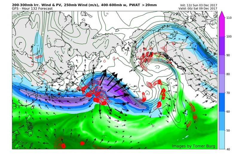
![]() by Frank_Wx Sat Dec 02, 2017 11:53 am
by Frank_Wx Sat Dec 02, 2017 11:53 am
Frank_Wx- Godzilla Seeker

- Posts : 21305
Join date : 2013-01-05 -

Re: Long Range Thread 15.0
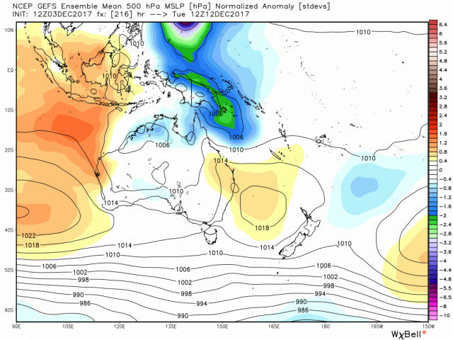
![]() by Math23x7 Sat Dec 02, 2017 12:22 pm
by Math23x7 Sat Dec 02, 2017 12:22 pm
Math23x7- Wx Statistician Guru

- Posts : 2379
Join date : 2013-01-08

mikeypizano- Pro Enthusiast

- Posts : 1118
Reputation : 66
Join date : 2017-01-05
Age : 35
Location : Wilkes-Barre/Scranton, PA
Re: Long Range Thread 15.0
![]() by Guest Sat Dec 02, 2017 1:02 pm
by Guest Sat Dec 02, 2017 1:02 pm
Guest- Guest
Re: Long Range Thread 15.0
![]() by amugs Sat Dec 02, 2017 10:10 pm
by amugs Sat Dec 02, 2017 10:10 pm
JMMath23x7 wrote:Mugs, which meteorologist did that quote come from?
_________________
Mugs
AKA:King: Snow Weenie
Self Proclaimed
WINTER 2014-15 : 55.12" +.02 for 6 coatings (avg. 35")
WINTER 2015-16 Total - 29.8" (Avg 35")
WINTER 2016-17 : 39.5" so far

amugs- Advanced Forecaster - Mod

- Posts : 15093
Reputation : 213
Join date : 2013-01-07
Age : 54
Location : Hillsdale,NJ
Re: Long Range Thread 15.0
![]() by amugs Sat Dec 02, 2017 10:12 pm
by amugs Sat Dec 02, 2017 10:12 pm
Also when??? What time frame 10-28th if that is what ur asking. Multiple storm chances
_________________
Mugs
AKA:King: Snow Weenie
Self Proclaimed
WINTER 2014-15 : 55.12" +.02 for 6 coatings (avg. 35")
WINTER 2015-16 Total - 29.8" (Avg 35")
WINTER 2016-17 : 39.5" so far
amugs- Advanced Forecaster - Mod
- Posts : 15093
Reputation : 213
Join date : 2013-01-07
Age : 54
Location : Hillsdale,NJ
Re: Long Range Thread 15.0
![]() by mikeypizano Sat Dec 02, 2017 10:13 pm
by mikeypizano Sat Dec 02, 2017 10:13 pm
mikeypizano- Pro Enthusiast
- Posts : 1118
Reputation : 66
Join date : 2017-01-05
Age : 35
Location : Wilkes-Barre/Scranton, PA
Re: Long Range Thread 15.0
![]() by amugs Sat Dec 02, 2017 11:01 pm
by amugs Sat Dec 02, 2017 11:01 pm

_________________
Mugs
AKA:King: Snow Weenie
Self Proclaimed
WINTER 2014-15 : 55.12" +.02 for 6 coatings (avg. 35")
WINTER 2015-16 Total - 29.8" (Avg 35")
WINTER 2016-17 : 39.5" so far
amugs- Advanced Forecaster - Mod
- Posts : 15093
Reputation : 213
Join date : 2013-01-07
Age : 54
Location : Hillsdale,NJ
Re: Long Range Thread 15.0
![]() by mikeypizano Sat Dec 02, 2017 11:49 pm
by mikeypizano Sat Dec 02, 2017 11:49 pm
mikeypizano- Pro Enthusiast
- Posts : 1118
Reputation : 66
Join date : 2017-01-05
Age : 35
Location : Wilkes-Barre/Scranton, PA
Re: Long Range Thread 15.0
![]() by Math23x7 Sat Dec 02, 2017 11:50 pm
by Math23x7 Sat Dec 02, 2017 11:50 pm
amugs wrote:JMMath23x7 wrote:Mugs, which meteorologist did that quote come from?
Who is JM?
Math23x7- Wx Statistician Guru
- Posts : 2379
Reputation : 68
Join date : 2013-01-08
Re: Long Range Thread 15.0
![]() by amugs Sun Dec 03, 2017 9:29 am
by amugs Sun Dec 03, 2017 9:29 am

_________________
Mugs
AKA:King: Snow Weenie
Self Proclaimed
WINTER 2014-15 : 55.12" +.02 for 6 coatings (avg. 35")
WINTER 2015-16 Total - 29.8" (Avg 35")
WINTER 2016-17 : 39.5" so far
amugs- Advanced Forecaster - Mod
- Posts : 15093
Reputation : 213
Join date : 2013-01-07
Age : 54
Location : Hillsdale,NJ
Re: Long Range Thread 15.0
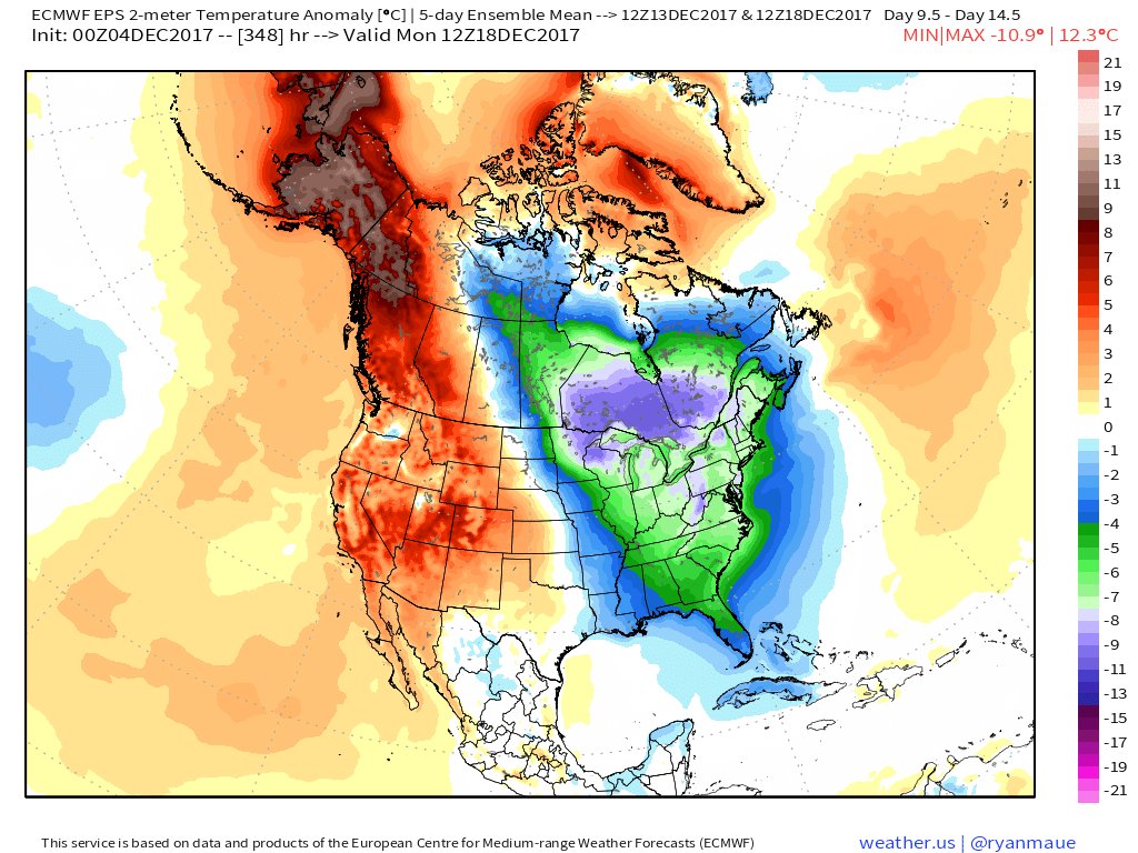
![]() by skinsfan1177 Sun Dec 03, 2017 9:34 am
by skinsfan1177 Sun Dec 03, 2017 9:34 am
amugs wrote:NOAA saying get out the thermal just a truly anamolous pattern!!
Been awhile seeing a pattern like that last that long Giddy up

skinsfan1177- Senior Enthusiast

- Posts : 4485
Reputation : 35
Join date : 2013-01-07
Age : 46
Location : Point Pleasant Boro
Re: Long Range Thread 15.0
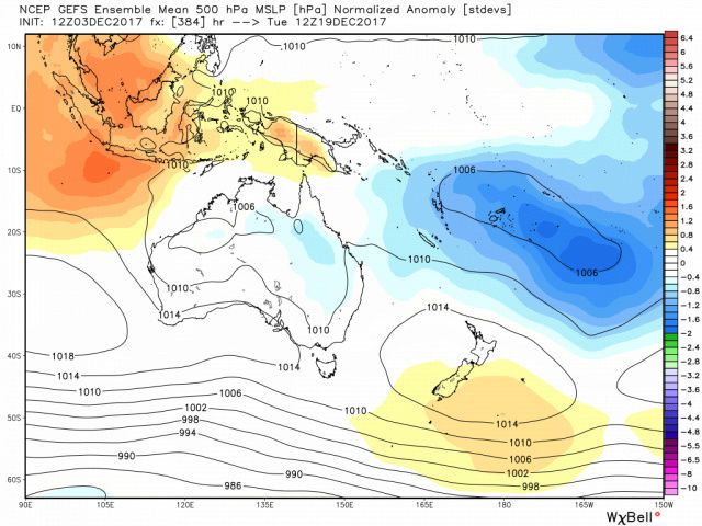
![]() by Math23x7 Sun Dec 03, 2017 2:22 pm
by Math23x7 Sun Dec 03, 2017 2:22 pm
Math23x7- Wx Statistician Guru
- Posts : 2379
Reputation : 68
Join date : 2013-01-08
Re: Long Range Thread 15.0
![]() by amugs Sun Dec 03, 2017 9:05 pm
by amugs Sun Dec 03, 2017 9:05 pm
_________________
Mugs
AKA:King: Snow Weenie
Self Proclaimed
WINTER 2014-15 : 55.12" +.02 for 6 coatings (avg. 35")
WINTER 2015-16 Total - 29.8" (Avg 35")
WINTER 2016-17 : 39.5" so far
amugs- Advanced Forecaster - Mod
- Posts : 15093
Reputation : 213
Join date : 2013-01-07
Age : 54
Location : Hillsdale,NJ
Re: Long Range Thread 15.0
![]() by amugs Sun Dec 03, 2017 9:54 pm
by amugs Sun Dec 03, 2017 9:54 pm

_________________
Mugs
AKA:King: Snow Weenie
Self Proclaimed
WINTER 2014-15 : 55.12" +.02 for 6 coatings (avg. 35")
WINTER 2015-16 Total - 29.8" (Avg 35")
WINTER 2016-17 : 39.5" so far
amugs- Advanced Forecaster - Mod
- Posts : 15093
Reputation : 213
Join date : 2013-01-07
Age : 54
Location : Hillsdale,NJ
Re: Long Range Thread 15.0
![]() by amugs Sun Dec 03, 2017 10:09 pm
by amugs Sun Dec 03, 2017 10:09 pm
.gif.233d7eabc66fb64264392dac8304eb53.gif)
_________________
Mugs
AKA:King: Snow Weenie
Self Proclaimed
WINTER 2014-15 : 55.12" +.02 for 6 coatings (avg. 35")
WINTER 2015-16 Total - 29.8" (Avg 35")
WINTER 2016-17 : 39.5" so far
amugs- Advanced Forecaster - Mod
- Posts : 15093
Reputation : 213
Join date : 2013-01-07
Age : 54
Location : Hillsdale,NJ
Re: Long Range Thread 15.0
![]() by amugs Sun Dec 03, 2017 10:11 pm
by amugs Sun Dec 03, 2017 10:11 pm
_________________
Mugs
AKA:King: Snow Weenie
Self Proclaimed
WINTER 2014-15 : 55.12" +.02 for 6 coatings (avg. 35")
WINTER 2015-16 Total - 29.8" (Avg 35")
WINTER 2016-17 : 39.5" so far
amugs- Advanced Forecaster - Mod
- Posts : 15093
Reputation : 213
Join date : 2013-01-07
Age : 54
Location : Hillsdale,NJ
Re: Long Range Thread 15.0
![]() by Frank_Wx Mon Dec 04, 2017 9:08 am
by Frank_Wx Mon Dec 04, 2017 9:08 am
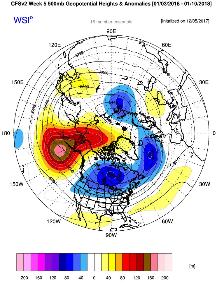
The GEFS suggests we'll remain cold into Christmas. It looks like the NAO blocking breaks down at some point, however. Luckily the WPO/EPO ridging means business. That could be a result of the active MJO. Lots to like in the long range but I would like to see one of these events materialize into a snowstorm
_________________
_______________________________________________________________________________________________________
CLICK HERE to view NJ Strong Snowstorm Classifications

Frank_Wx- Godzilla Seeker
- Posts : 21305
Reputation : 328
Join date : 2013-01-05
Age : 31
Location : Jersey City, NJ -
Re: Long Range Thread 15.0
![]() by amugs Mon Dec 04, 2017 9:38 am
by amugs Mon Dec 04, 2017 9:38 am
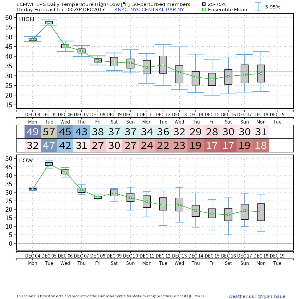
This is VERY IMPRESSIVE for temps
_________________
Mugs
AKA:King: Snow Weenie
Self Proclaimed
WINTER 2014-15 : 55.12" +.02 for 6 coatings (avg. 35")
WINTER 2015-16 Total - 29.8" (Avg 35")
WINTER 2016-17 : 39.5" so far
amugs- Advanced Forecaster - Mod
- Posts : 15093
Reputation : 213
Join date : 2013-01-07
Age : 54
Location : Hillsdale,NJ
Re: Long Range Thread 15.0
![]() by amugs Mon Dec 04, 2017 9:41 am
by amugs Mon Dec 04, 2017 9:41 am
BARNEY

MICK - GREEN!!
_________________
Mugs
AKA:King: Snow Weenie
Self Proclaimed
WINTER 2014-15 : 55.12" +.02 for 6 coatings (avg. 35")
WINTER 2015-16 Total - 29.8" (Avg 35")
WINTER 2016-17 : 39.5" so far
amugs- Advanced Forecaster - Mod
- Posts : 15093
Reputation : 213
Join date : 2013-01-07
Age : 54
Location : Hillsdale,NJ
Re: Long Range Thread 15.0
![]() by amugs Mon Dec 04, 2017 10:27 am
by amugs Mon Dec 04, 2017 10:27 am
_________________
Mugs
AKA:King: Snow Weenie
Self Proclaimed
WINTER 2014-15 : 55.12" +.02 for 6 coatings (avg. 35")
WINTER 2015-16 Total - 29.8" (Avg 35")
WINTER 2016-17 : 39.5" so far
amugs- Advanced Forecaster - Mod
- Posts : 15093
Reputation : 213
Join date : 2013-01-07
Age : 54
Location : Hillsdale,NJ
Re: Long Range Thread 15.0
![]() by algae888 Tue Dec 05, 2017 6:04 pm
by algae888 Tue Dec 05, 2017 6:04 pm
There is potential for a storm to start impacting the area beginning
on Tue, more likely Tue night, as the mean trough to the west
reloads and then significantly amplifies, with both GFS/ECMWF
showing incipient low pressure over the Mid Atlantic region bombing
out as it moves offshore the Mid Atlantic and New England coasts.
Longer range models have advertised this possibility for some time
now, but details are by design sketchy. If the currently advertised
GFS/ECMWF scenario were to pan out, with lack of a strong high to
the NE to supply cold air, this would likely be more of an interior
snow event inland, with rain at the coast. We have a long way to go
to follow model trends with this potential event.

algae888- Advanced Forecaster

- Posts : 5311
Reputation : 46
Join date : 2013-02-05
Age : 61
Location : mt. vernon, new york
Re: Long Range Thread 15.0
![]() by Guest Tue Dec 05, 2017 6:10 pm
by Guest Tue Dec 05, 2017 6:10 pm
algae888 wrote:n and w folks do not get upset if this weekends snow passes you by. more great disco from the pro's...
There is potential for a storm to start impacting the area beginning
on Tue, more likely Tue night, as the mean trough to the west
reloads and then significantly amplifies, with both GFS/ECMWF
showing incipient low pressure over the Mid Atlantic region bombing
out as it moves offshore the Mid Atlantic and New England coasts.
Longer range models have advertised this possibility for some time
now, but details are by design sketchy. If the currently advertised
GFS/ECMWF scenario were to pan out, with lack of a strong high to
the NE to supply cold air, this would likely be more of an interior
snow event inland, with rain at the coast. We have a long way to go
to follow model trends with this potential event.
What happened to the telecommunications being set up in such an epic way that the cold would be locked in such a manner that we haven’t seen in years. Then as we get into the second week of December we’re talking about the possibility of no cold air and rain?
Yes I know it’s the LR and it’s just a possibility but what gives?
Guest- Guest
Re: Long Range Thread 15.0
![]() by algae888 Tue Dec 05, 2017 6:21 pm
by algae888 Tue Dec 05, 2017 6:21 pm
just because we have great setups doesn't always mean snow. climo is still against us in early mid dec especially with warm to warmer than normal ocean temps. we only ave. 4" of snow in December so any one expecting a lot more could be disappointed. all I can ask for is the chance for it to snow. we have the cold. we will have that for awhile unlike the last several years. I still believe we will end up with more than 4" when dec is done. every storm though probably will not be snow.syosnow94 wrote:algae888 wrote:n and w folks do not get upset if this weekends snow passes you by. more great disco from the pro's...
There is potential for a storm to start impacting the area beginning
on Tue, more likely Tue night, as the mean trough to the west
reloads and then significantly amplifies, with both GFS/ECMWF
showing incipient low pressure over the Mid Atlantic region bombing
out as it moves offshore the Mid Atlantic and New England coasts.
Longer range models have advertised this possibility for some time
now, but details are by design sketchy. If the currently advertised
GFS/ECMWF scenario were to pan out, with lack of a strong high to
the NE to supply cold air, this would likely be more of an interior
snow event inland, with rain at the coast. We have a long way to go
to follow model trends with this potential event.
What happened to the telecommunications being set up in such an epic way that the cold would be locked in such a manner that we haven’t seen in years. Then as we get into the second week of December we’re talking about the possibility of no cold air and rain?
Yes I know it’s the LR and it’s just a possibility but what gives?
algae888- Advanced Forecaster
- Posts : 5311
Reputation : 46
Join date : 2013-02-05
Age : 61
Location : mt. vernon, new york
Re: Long Range Thread 15.0
![]() by amugs Wed Dec 06, 2017 10:44 am
by amugs Wed Dec 06, 2017 10:44 am
_________________
Mugs
AKA:King: Snow Weenie
Self Proclaimed
WINTER 2014-15 : 55.12" +.02 for 6 coatings (avg. 35")
WINTER 2015-16 Total - 29.8" (Avg 35")
WINTER 2016-17 : 39.5" so far
amugs- Advanced Forecaster - Mod
- Posts : 15093
Reputation : 213
Join date : 2013-01-07
Age : 54
Location : Hillsdale,NJ
Re: Long Range Thread 15.0
![]() by amugs Wed Dec 06, 2017 12:53 pm
by amugs Wed Dec 06, 2017 12:53 pm
"GFS has trended way better for the 12/13 event with the REMOVAL of a huge TPV. This storm then becomes its own entity much faster and jet dynamics with moisture are prevalent. This is trending better rapidly ."
IN ADDITION
The loss of the huge TPV phase in the Northeast means it elongates quickly. We have a KU look in under 240 hours if that is correct. Go watch the evolution yourself!
MOTHER OF GODDDDDDDDD!!!!!!!!
HE NEVER SAYS SUCH AT THIS RANGE!!
_________________
Mugs
AKA:King: Snow Weenie
Self Proclaimed
WINTER 2014-15 : 55.12" +.02 for 6 coatings (avg. 35")
WINTER 2015-16 Total - 29.8" (Avg 35")
WINTER 2016-17 : 39.5" so far
amugs- Advanced Forecaster - Mod
- Posts : 15093
Reputation : 213
Join date : 2013-01-07
Age : 54
Location : Hillsdale,NJ
Re: Long Range Thread 15.0
![]() by mikeypizano Wed Dec 06, 2017 1:02 pm
by mikeypizano Wed Dec 06, 2017 1:02 pm
mikeypizano- Pro Enthusiast
- Posts : 1118
Reputation : 66
Join date : 2017-01-05
Age : 35
Location : Wilkes-Barre/Scranton, PA
Page 15 of 42 • 1 ... 9 ... 14, 15, 16 ... 28 ... 42 ![]()
|
|
|