
 Search
Long Range Thread 15.0
Page 14 of 42 •  1 ... 8 ... 13, 14, 15 ... 28 ... 42
 ![]()
Re: Long Range Thread 15.0
![]() by sroc4 Thu Nov 30, 2017 9:31 pm
by sroc4 Thu Nov 30, 2017 9:31 pm
Dunnzoo wrote:amugs wrote:Dunnzoo wrote:Of course! The one time in months I am going out to LI and it might snow!
You may get snowed in the LOL!!

I'll go hang out with Scott, but it slowed down on 18z, showing for Sunday
We’ll drink and toast in the snow capital of the northeast. To White Gold!
sroc4- Admin

- Posts : 8331
Join date : 2013-01-07
Re: Long Range Thread 15.0
![]() by Frank_Wx Fri Dec 01, 2017 10:30 am
by Frank_Wx Fri Dec 01, 2017 10:30 am

Frank_Wx- Godzilla Seeker
- Posts : 21305
Join date : 2013-01-05 -

Re: Long Range Thread 15.0
![]() by amugs Fri Dec 01, 2017 10:55 am
by amugs Fri Dec 01, 2017 10:55 am
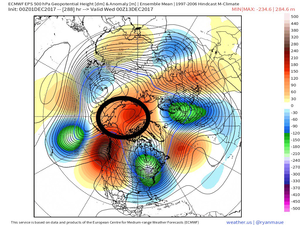
One of the key pieces to the longevity of cold and stormy weather in Central and Eastern US will be the poleward build of anomalous Pacific ridging. ECMWF EPS builds ridging into the EPO/AO regions through 10+ days (‘13-‘14 esq).
_________________
Mugs
AKA:King: Snow Weenie
Self Proclaimed
WINTER 2014-15 : 55.12" +.02 for 6 coatings (avg. 35")
WINTER 2015-16 Total - 29.8" (Avg 35")
WINTER 2016-17 : 39.5" so far

amugs- Advanced Forecaster - Mod

- Posts : 15093
Reputation : 213
Join date : 2013-01-07
Age : 54
Location : Hillsdale,NJ
Re: Long Range Thread 15.0
![]() by Snow88 Fri Dec 01, 2017 12:54 pm
by Snow88 Fri Dec 01, 2017 12:54 pm

Snow88- Senior Enthusiast

- Posts : 2193
Reputation : 4
Join date : 2013-01-09
Age : 35
Location : Brooklyn, NY
Re: Long Range Thread 15.0
![]() by amugs Fri Dec 01, 2017 3:59 pm
by amugs Fri Dec 01, 2017 3:59 pm

_________________
Mugs
AKA:King: Snow Weenie
Self Proclaimed
WINTER 2014-15 : 55.12" +.02 for 6 coatings (avg. 35")
WINTER 2015-16 Total - 29.8" (Avg 35")
WINTER 2016-17 : 39.5" so far
amugs- Advanced Forecaster - Mod
- Posts : 15093
Reputation : 213
Join date : 2013-01-07
Age : 54
Location : Hillsdale,NJ
Re: Long Range Thread 15.0
![]() by amugs Fri Dec 01, 2017 8:20 pm
by amugs Fri Dec 01, 2017 8:20 pm

_________________
Mugs
AKA:King: Snow Weenie
Self Proclaimed
WINTER 2014-15 : 55.12" +.02 for 6 coatings (avg. 35")
WINTER 2015-16 Total - 29.8" (Avg 35")
WINTER 2016-17 : 39.5" so far
amugs- Advanced Forecaster - Mod
- Posts : 15093
Reputation : 213
Join date : 2013-01-07
Age : 54
Location : Hillsdale,NJ
Re: Long Range Thread 15.0
![]() by amugs Fri Dec 01, 2017 8:27 pm
by amugs Fri Dec 01, 2017 8:27 pm
_________________
Mugs
AKA:King: Snow Weenie
Self Proclaimed
WINTER 2014-15 : 55.12" +.02 for 6 coatings (avg. 35")
WINTER 2015-16 Total - 29.8" (Avg 35")
WINTER 2016-17 : 39.5" so far
amugs- Advanced Forecaster - Mod
- Posts : 15093
Reputation : 213
Join date : 2013-01-07
Age : 54
Location : Hillsdale,NJ
Re: Long Range Thread 15.0
![]() by amugs Fri Dec 01, 2017 9:48 pm
by amugs Fri Dec 01, 2017 9:48 pm
He


_________________
Mugs
AKA:King: Snow Weenie
Self Proclaimed
WINTER 2014-15 : 55.12" +.02 for 6 coatings (avg. 35")
WINTER 2015-16 Total - 29.8" (Avg 35")
WINTER 2016-17 : 39.5" so far
amugs- Advanced Forecaster - Mod
- Posts : 15093
Reputation : 213
Join date : 2013-01-07
Age : 54
Location : Hillsdale,NJ
Re: Long Range Thread 15.0
![]() by amugs Fri Dec 01, 2017 9:53 pm
by amugs Fri Dec 01, 2017 9:53 pm


_________________
Mugs
AKA:King: Snow Weenie
Self Proclaimed
WINTER 2014-15 : 55.12" +.02 for 6 coatings (avg. 35")
WINTER 2015-16 Total - 29.8" (Avg 35")
WINTER 2016-17 : 39.5" so far
amugs- Advanced Forecaster - Mod
- Posts : 15093
Reputation : 213
Join date : 2013-01-07
Age : 54
Location : Hillsdale,NJ
Re: Long Range Thread 15.0
![]() by frank 638 Fri Dec 01, 2017 10:20 pm
by frank 638 Fri Dec 01, 2017 10:20 pm
frank 638- Senior Enthusiast
- Posts : 2825
Reputation : 37
Join date : 2016-01-01
Age : 40
Location : bronx ny
Re: Long Range Thread 15.0
![]() by mikeypizano Fri Dec 01, 2017 10:26 pm
by mikeypizano Fri Dec 01, 2017 10:26 pm
frank 638 wrote:Amugs I am freaking excited it's about time . after dealing with 2 horrible Winters we deserve this bring on the cold and snow because I am ready
I bought another snow blower this year, to replace an old MTD single stage, 3 shovels, 2 pairs of boots, and 3 pairs of gloves...

mikeypizano- Pro Enthusiast

- Posts : 1118
Reputation : 66
Join date : 2017-01-05
Age : 35
Location : Wilkes-Barre/Scranton, PA
Re: Long Range Thread 15.0
![]() by Dunnzoo Fri Dec 01, 2017 11:14 pm
by Dunnzoo Fri Dec 01, 2017 11:14 pm
amugs wrote:Start is really amazing serious wind reversal here as noted by a met from another board who liv3s in the next town from me
He
Who's the met? I know one here in Westwood, but doesn't do it professionally....
_________________
Janet
Snowfall winter of 2023-2024 17.5"
Snowfall winter of 2022-2023 6.0"
Snowfall winter of 2021-2022 17.6" 1" sleet 2/25/22
Snowfall winter of 2020-2021 51.1"
Snowfall winter of 2019-2020 8.5"
Snowfall winter of 2018-2019 25.1"
Snowfall winter of 2017-2018 51.9"
Snowfall winter of 2016-2017 45.6"
Snowfall winter of 2015-2016 29.5"
Snowfall winter of 2014-2015 50.55"
Snowfall winter of 2013-2014 66.5"

Dunnzoo- Senior Enthusiast - Mod
- Posts : 4892
Reputation : 68
Join date : 2013-01-11
Age : 62
Location : Westwood, NJ
Re: Long Range Thread 15.0
![]() by Dunnzoo Fri Dec 01, 2017 11:15 pm
by Dunnzoo Fri Dec 01, 2017 11:15 pm
mikeypizano wrote:frank 638 wrote:Amugs I am freaking excited it's about time . after dealing with 2 horrible Winters we deserve this bring on the cold and snow because I am ready
I bought another snow blower this year, to replace an old MTD single stage, 3 shovels, 2 pairs of boots, and 3 pairs of gloves...
uhoh Mikey, kiss of death! We're doomed!
_________________
Janet
Snowfall winter of 2023-2024 17.5"
Snowfall winter of 2022-2023 6.0"
Snowfall winter of 2021-2022 17.6" 1" sleet 2/25/22
Snowfall winter of 2020-2021 51.1"
Snowfall winter of 2019-2020 8.5"
Snowfall winter of 2018-2019 25.1"
Snowfall winter of 2017-2018 51.9"
Snowfall winter of 2016-2017 45.6"
Snowfall winter of 2015-2016 29.5"
Snowfall winter of 2014-2015 50.55"
Snowfall winter of 2013-2014 66.5"
Dunnzoo- Senior Enthusiast - Mod
- Posts : 4892
Reputation : 68
Join date : 2013-01-11
Age : 62
Location : Westwood, NJ
Re: Long Range Thread 15.0
![]() by mikeypizano Fri Dec 01, 2017 11:33 pm
by mikeypizano Fri Dec 01, 2017 11:33 pm
Dunnzoo wrote:mikeypizano wrote:frank 638 wrote:Amugs I am freaking excited it's about time . after dealing with 2 horrible Winters we deserve this bring on the cold and snow because I am ready
I bought another snow blower this year, to replace an old MTD single stage, 3 shovels, 2 pairs of boots, and 3 pairs of gloves...
uhoh Mikey, kiss of death! We're doomed!
I am in this to make money... :p
mikeypizano- Pro Enthusiast
- Posts : 1118
Reputation : 66
Join date : 2017-01-05
Age : 35
Location : Wilkes-Barre/Scranton, PA
Re: Long Range Thread 15.0
![]() by amugs Sat Dec 02, 2017 7:49 am
by amugs Sat Dec 02, 2017 7:49 am
_________________
Mugs
AKA:King: Snow Weenie
Self Proclaimed
WINTER 2014-15 : 55.12" +.02 for 6 coatings (avg. 35")
WINTER 2015-16 Total - 29.8" (Avg 35")
WINTER 2016-17 : 39.5" so far
amugs- Advanced Forecaster - Mod
- Posts : 15093
Reputation : 213
Join date : 2013-01-07
Age : 54
Location : Hillsdale,NJ
Re: Long Range Thread 15.0
![]() by sroc4 Sat Dec 02, 2017 8:22 am
by sroc4 Sat Dec 02, 2017 8:22 am
amugs wrote:Oh and Math Steve D your boy is saying massive feedback loop of cold and snow for next 3 weeks. The block is overy the top makes a horseshoe and locks in the trough and PV with a scan block, and epo block with a Russian block on the top that extends into the NAO. Heights pumped on the west coast. If it's doesn't get one exited and scream.potential then Frank should just shut the door!
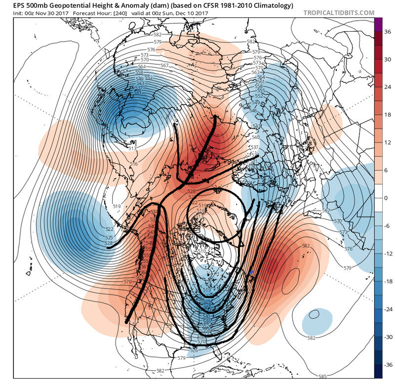
A causual observation I have been noticing in the ensemble means is the intensity of the higher height anomalies seem to be trending weaker and more zonal over N Atlantic and Greenland area in the means. So where we may technically get a -NAO on the graphs I worry it might not be a true blocking -NAO. Looking at the EPS image you posted above. We need to see higher heights extend up into the Greenland area to slow the up stream flow. (off the EC).
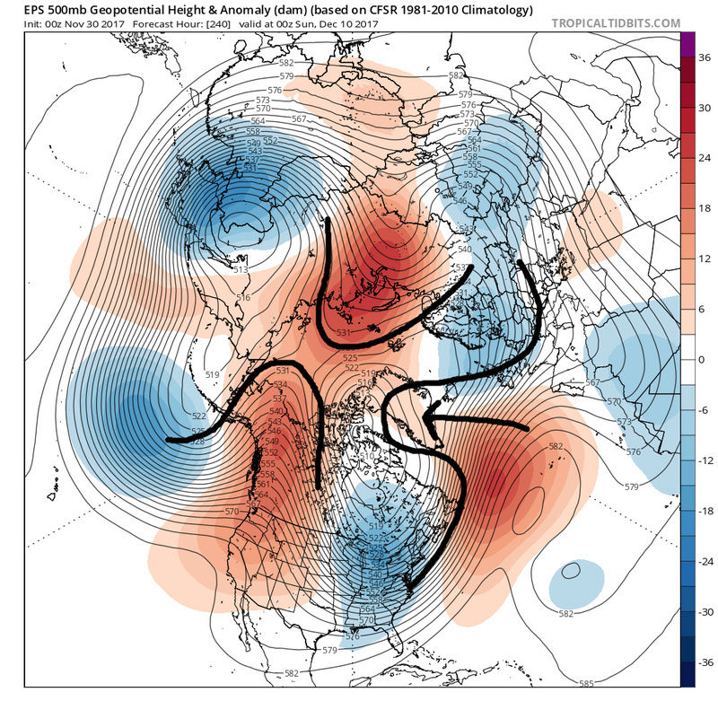
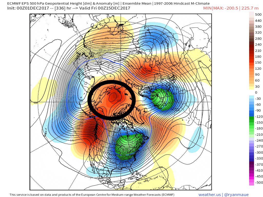
If the EPS were to verify verbatim it would lead to very flat heights in the N Atlantic which would lead to a very progressive flow off the EC. The -EPO/+PNA/-AO would undoubtedly still give us a mean trough in the east and well below normal temps, but the "flat"/zonal flow in the N Atl means a storm track S&E and suppression depression. This would still offer snow opportunity but more in the form of quick hittters or inverted trough like feautures rather than bigger Nor easters. Of course even with a mean proggressive flow off the EC it doesnt mean we cant get a ell timed s/w dive in and phase with a s/w in the STJ leading to a more significant storm. Again this is verbatim as per the current EPS means. The GFS op map you posted has a much better look in the NAO region around the 15th but that's an Op run 13days from now..need I say more.


Last edited by sroc4 on Sat Dec 02, 2017 8:26 am; edited 1 time in total
_________________
"In weather and in life, there's no winning and losing; there's only winning and learning."
WINTER 2012/2013 TOTALS 43.65"WINTER 2017/2018 TOTALS 62.85" WINTER 2022/2023 TOTALS 4.9"
WINTER 2013/2014 TOTALS 64.85"WINTER 2018/2019 TOTALS 14.25" WINTER 2023/2024 TOTALS 13.1"
WINTER 2014/2015 TOTALS 71.20"WINTER 2019/2020 TOTALS 6.35"
WINTER 2015/2016 TOTALS 35.00"WINTER 2020/2021 TOTALS 37.75"
WINTER 2016/2017 TOTALS 42.25"WINTER 2021/2022 TOTALS 31.65"

sroc4- Admin
- Posts : 8331
Reputation : 301
Join date : 2013-01-07
Location : Wading River, LI
Re: Long Range Thread 15.0
![]() by amugs Sat Dec 02, 2017 8:23 am
by amugs Sat Dec 02, 2017 8:23 am
JB wrote in depth about this yesterday saying he wasn't buying the forecast and likened it to 2010!

_________________
Mugs
AKA:King: Snow Weenie
Self Proclaimed
WINTER 2014-15 : 55.12" +.02 for 6 coatings (avg. 35")
WINTER 2015-16 Total - 29.8" (Avg 35")
WINTER 2016-17 : 39.5" so far
amugs- Advanced Forecaster - Mod
- Posts : 15093
Reputation : 213
Join date : 2013-01-07
Age : 54
Location : Hillsdale,NJ
Re: Long Range Thread 15.0
![]() by amugs Sat Dec 02, 2017 8:42 am
by amugs Sat Dec 02, 2017 8:42 am
Two - I have stated and will continue to do that the pattern is there and will improve with each successive run to the true atmospheric conditions IE - PAC wave breaks and interference of the map I posted from Ventrice, East Asian Moutain Torque, MJO state and convection areas, STRAT, ARCTIC poleward intrusion and massive extension, LOW AAM, SCAN Bloc.
The pattern is saying POTENTIAL IMO and it will improve as the models start to sample the cold air and vorts that will be rounding the base of the H5 PV and trough. We are talking possible hours of separation from a couple of inches to a SECS type storm. Once teh pattern matures by midish December then I think we can start to see the possibilities increase of SECS type storms possible MECS IF things align (22-23rd time frame by Jim Witt!!)
Is there still a progressive flow at this time - OH yes there is but a PAC Block (Negative EPO) with a Positive SD 2-3 PNA and SCAN Block -East Based NAO we will do ala 2013.
The cold and snow will have a feedback on each other as Steve D talked about and so do pro mets JH, JM,, JB, JD, DS, SC all discuss. They all believe it will last through the new year - like Isotherm and my LR Winter forecasts and then relax and then reload for how long is a question that will be answered in the next few weeks.
_________________
Mugs
AKA:King: Snow Weenie
Self Proclaimed
WINTER 2014-15 : 55.12" +.02 for 6 coatings (avg. 35")
WINTER 2015-16 Total - 29.8" (Avg 35")
WINTER 2016-17 : 39.5" so far
amugs- Advanced Forecaster - Mod
- Posts : 15093
Reputation : 213
Join date : 2013-01-07
Age : 54
Location : Hillsdale,NJ
Re: Long Range Thread 15.0
![]() by amugs Sat Dec 02, 2017 8:45 am
by amugs Sat Dec 02, 2017 8:45 am

_________________
Mugs
AKA:King: Snow Weenie
Self Proclaimed
WINTER 2014-15 : 55.12" +.02 for 6 coatings (avg. 35")
WINTER 2015-16 Total - 29.8" (Avg 35")
WINTER 2016-17 : 39.5" so far
amugs- Advanced Forecaster - Mod
- Posts : 15093
Reputation : 213
Join date : 2013-01-07
Age : 54
Location : Hillsdale,NJ
Re: Long Range Thread 15.0
![]() by weatherwatchermom Sat Dec 02, 2017 9:03 am
by weatherwatchermom Sat Dec 02, 2017 9:03 am
amugs wrote:Arctic front snows - JESUS my son out at PSU looks to get burried of the=is comes to fruition!!
guess you are taking a sick day and going to drive out early to spend some quality time with your son at school??!!

weatherwatchermom- Senior Enthusiast
- Posts : 3750
Reputation : 77
Join date : 2014-11-25
Age : 60
Location : Hazlet Township, NJ
Re: Long Range Thread 15.0
![]() by sroc4 Sat Dec 02, 2017 9:11 am
by sroc4 Sat Dec 02, 2017 9:11 am
If the N Atlantic is more zonal then the potential for mecs and hecs decreases over the next two weeks and potential for a suppressed storm track increases. But again as stated a well timed digging polar s/w can still produce a mecs in this pattern.
_________________
"In weather and in life, there's no winning and losing; there's only winning and learning."
WINTER 2012/2013 TOTALS 43.65"WINTER 2017/2018 TOTALS 62.85" WINTER 2022/2023 TOTALS 4.9"
WINTER 2013/2014 TOTALS 64.85"WINTER 2018/2019 TOTALS 14.25" WINTER 2023/2024 TOTALS 13.1"
WINTER 2014/2015 TOTALS 71.20"WINTER 2019/2020 TOTALS 6.35"
WINTER 2015/2016 TOTALS 35.00"WINTER 2020/2021 TOTALS 37.75"
WINTER 2016/2017 TOTALS 42.25"WINTER 2021/2022 TOTALS 31.65"
sroc4- Admin
- Posts : 8331
Reputation : 301
Join date : 2013-01-07
Location : Wading River, LI
Re: Long Range Thread 15.0
![]() by Snow88 Sat Dec 02, 2017 9:58 am
by Snow88 Sat Dec 02, 2017 9:58 am
Snow88- Senior Enthusiast
- Posts : 2193
Reputation : 4
Join date : 2013-01-09
Age : 35
Location : Brooklyn, NY
Re: Long Range Thread 15.0
![]() by mikeypizano Sat Dec 02, 2017 10:26 am
by mikeypizano Sat Dec 02, 2017 10:26 am
mikeypizano- Pro Enthusiast
- Posts : 1118
Reputation : 66
Join date : 2017-01-05
Age : 35
Location : Wilkes-Barre/Scranton, PA
Re: Long Range Thread 15.0
![]() by amugs Sat Dec 02, 2017 11:42 am
by amugs Sat Dec 02, 2017 11:42 am
"Everything you could hope for to see a MECS/HECS with this ENSO and backround state is happening...everything.........."


_________________
Mugs
AKA:King: Snow Weenie
Self Proclaimed
WINTER 2014-15 : 55.12" +.02 for 6 coatings (avg. 35")
WINTER 2015-16 Total - 29.8" (Avg 35")
WINTER 2016-17 : 39.5" so far
amugs- Advanced Forecaster - Mod
- Posts : 15093
Reputation : 213
Join date : 2013-01-07
Age : 54
Location : Hillsdale,NJ
Re: Long Range Thread 15.0
![]() by amugs Sat Dec 02, 2017 11:47 am
by amugs Sat Dec 02, 2017 11:47 am
sroc4 wrote:Mugs my post in no way was to challenge anything you said nor did I think you were calling for a hecs/mecs etc, but rather to comment on the potential in front of us. It’s certainly easier to get it to snow if the cold is in place when mid level energy arrives vs needing to generate the cold with a phase etc. There is now doubt the cold air is coming which increases our potential, but you can have all the potential in the world but it means nothing until it actually happens. Johnny Manzel had all the potential in the world and look how that worked out. Lol
If the N Atlantic is more zonal then the potential for mecs and hecs decreases over the next two weeks and potential for a suppressed storm track increases. But again as stated a well timed digging polar s/w can still produce a mecs in this pattern.
Paisan and my mini me 12 years younger!
I re read your post and I jumped the gun a bit, my apologies.
But as you see from my posts, yes it may zonal but the 10-28th time frame looks to be loaded. Johnny Manzel, Marcus Dupree, Steve Kemp, etc etc.. This is Big Momma talkin' to us and she is saying better get yuor ducks lined up outside this weekend cause by this time next time week we will be cold and possibly white gold on the ground!!
_________________
Mugs
AKA:King: Snow Weenie
Self Proclaimed
WINTER 2014-15 : 55.12" +.02 for 6 coatings (avg. 35")
WINTER 2015-16 Total - 29.8" (Avg 35")
WINTER 2016-17 : 39.5" so far
amugs- Advanced Forecaster - Mod
- Posts : 15093
Reputation : 213
Join date : 2013-01-07
Age : 54
Location : Hillsdale,NJ
Re: Long Range Thread 15.0
![]() by Frank_Wx Sat Dec 02, 2017 11:53 am
by Frank_Wx Sat Dec 02, 2017 11:53 am
_________________
_______________________________________________________________________________________________________
CLICK HERE to view NJ Strong Snowstorm Classifications

Frank_Wx- Godzilla Seeker
- Posts : 21305
Reputation : 328
Join date : 2013-01-05
Age : 31
Location : Jersey City, NJ -
Re: Long Range Thread 15.0
![]() by Math23x7 Sat Dec 02, 2017 12:22 pm
by Math23x7 Sat Dec 02, 2017 12:22 pm
Math23x7- Wx Statistician Guru

- Posts : 2379
Reputation : 68
Join date : 2013-01-08
Page 14 of 42 • 1 ... 8 ... 13, 14, 15 ... 28 ... 42 ![]()
|
|
|