
 Search
Possible Snowstorm December 8th-9th
Page 1 of 15 • 1, 2, 3 ... 8 ... 15 ![]()

Possible Snowstorm December 8th-9th
![]() by Frank_Wx Sat Dec 02, 2017 11:52 am
by Frank_Wx Sat Dec 02, 2017 11:52 am
Yesterday was the official start of Meteorological Winter and Mother Nature is wasting no time in trying to make it feel like winter. In the long range thread, myself and others made it clear December 6th, after the passage of an arctic front, will be the transition day to a pattern change to colder than normal weather conditions.

Here is the 500mb vorticity map valid 7am Tuesday December 5th. The deep oranges in northern Wisconsin and Michigan came from the Pacific and is about to phase with the Polar Vortex. A very strong blizzard will impact south-central Canada as a result. This potent Low Pressure will track east across Canada and along the thermal boundary will be an arctic front. This front is expected to sweep through our area late Tuesday or early Wednesday bringing rain, but do not be surprised to see rain change to snow in some locations, possibly even the NYC area.

Here is a better view of this set-up. Notice the 975mb low in Canada and the front draping along the east coast of the U.S.
Cold air is expected to settle in behind this front. High temperatures beginning on Wednesday may not get out of the 30's. Most likely, High's in the upper 30's to low 40's through next weekend and into the week of the 10th. There will be days mixed in where we will not get out of the 20's!
Because we'll have this cold air around, the threat of a snowstorm exists for December 8th-9th time frame.

As is the case with any snowstorm, there is southern and northern energy and we need the 2 to phase for an organized low pressure system to develop. Here is the 500mb vort map from the 12z GFS. Notice the southern energy tries to escape the northern energy. I circled the two for you in lime green. And because the northern energy is SO strong (darker/deeper the orange the more potent the upper energy), it slows down the evolution of the phase and even tries to make heights rise along the east coast. I mean, the Polar Vortex is basically over the Great Lakes and that is not very common. The reason why we're seeing such a strong northern branch is because of the anomalous Pacific blocking. The PNA/EPO is expected to get so negative that it displaces polar cold from the North Pole / Arctic region into the central and eastern U.S. It is an over-powering situation.

What is kinda neat is that if we miss the phase on December 8th, there is still an opportunity for someone to receive lots of snow on December 9th from an Inverted Trough. Because we have Pacific AND Atlantic blocking (west and east most green lines) the trough that drops into the eastern U.S. has no choice but to go on a negative tilt. Look how the cold air source connect, or comes directly from the Arctic region. This is major cold we're talking about. The problem with IVT is they are difficult to pinpoint. Most likely, this situation will not get resolved until the end of next week.
So, hope for the phase on December 8th so everyone cashes in on some snow. If not, we'll have to see what happens with the IVT on December 9th.
Luckily, there are more storm threats even beyond this time frame which we'll keep talking about in the Long Range thread.
Have a nice weekend
-Frank
_________________
_______________________________________________________________________________________________________
CLICK HERE to view NJ Strong Snowstorm Classifications

Frank_Wx- Godzilla Seeker

- Posts : 21305
Reputation : 328
Join date : 2013-01-05
Age : 32
Location : Jersey City, NJ -

Re: Possible Snowstorm December 8th-9th
![]() by mikeypizano Sat Dec 02, 2017 12:01 pm
by mikeypizano Sat Dec 02, 2017 12:01 pm

mikeypizano- Pro Enthusiast

- Posts : 1118
Reputation : 66
Join date : 2017-01-05
Age : 35
Location : Wilkes-Barre/Scranton, PA
Re: Possible Snowstorm December 8th-9th
![]() by Wheezer Sat Dec 02, 2017 1:25 pm
by Wheezer Sat Dec 02, 2017 1:25 pm
Frank_Wx wrote:Good Morning -
Yesterday was the official start of Meteorological Winter and Mother Nature is wasting no time in trying to make it feel like winter. In the long range thread, myself and others made it clear December 6th, after the passage of an arctic front, will be the transition day to a pattern change to colder than normal weather conditions.
Here is the 500mb vorticity map valid 7am Tuesday December 5th. The deep oranges in northern Wisconsin and Michigan came from the Pacific and is about to phase with the Polar Vortex. A very strong blizzard will impact south-central Canada as a result. This potent Low Pressure will track east across Canada and along the thermal boundary will be an arctic front. This front is expected to sweep through our area late Tuesday or early Wednesday bringing rain, but do not be surprised to see rain change to snow in some locations, possibly even the NYC area.
Here is a better view of this set-up. Notice the 975mb low in Canada and the front draping along the east coast of the U.S.
Cold air is expected to settle in behind this front. High temperatures beginning on Wednesday may not get out of the 30's. Most likely, High's in the upper 30's to low 40's through next weekend and into the week of the 10th. There will be days mixed in where we will not get out of the 20's!
Because we'll have this cold air around, the threat of a snowstorm exists for December 8th-9th time frame.
As is the case with any snowstorm, there is southern and northern energy and we need the 2 to phase for an organized low pressure system to develop. Here is the 500mb vort map from the 12z GFS. Notice the southern energy tries to escape the northern energy. I circled the two for you in lime green. And because the northern energy is SO strong (darker/deeper the orange the more potent the upper energy), it slows down the evolution of the phase and even tries to make heights rise along the east coast. I mean, the Polar Vortex is basically over the Great Lakes and that is not very common. The reason why we're seeing such a strong northern branch is because of the anomalous Pacific blocking. The PNA/EPO is expected to get so negative that it displaces polar cold from the North Pole / Arctic region into the central and eastern U.S. It is an over-powering situation.
What is kinda neat is that if we miss the phase on December 8th, there is still an opportunity for someone to receive lots of snow on December 9th from an Inverted Trough. Because we have Pacific AND Atlantic blocking (west and east most green lines) the trough that drops into the eastern U.S. has no choice but to go on a negative tilt. Look how the cold air source connect, or comes directly from the Arctic region. This is major cold we're talking about. The problem with IVT is they are difficult to pinpoint. Most likely, this situation will not get resolved until the end of next week.
So, hope for the phase on December 8th so everyone cashes in on some snow. If not, we'll have to see what happens with the IVT on December 9th.
Luckily, there are more storm threats even beyond this time frame which we'll keep talking about in the Long Range thread.
Have a nice weekend
-Frank
Thank you for in depth comments, so helpful for those that are still learning.
Wheezer- Posts : 30
Reputation : 6
Join date : 2017-11-08
Location : Cincinnati, Oh
Re: Possible Snowstorm December 8th-9th
![]() by Frank_Wx Sat Dec 02, 2017 2:22 pm
by Frank_Wx Sat Dec 02, 2017 2:22 pm
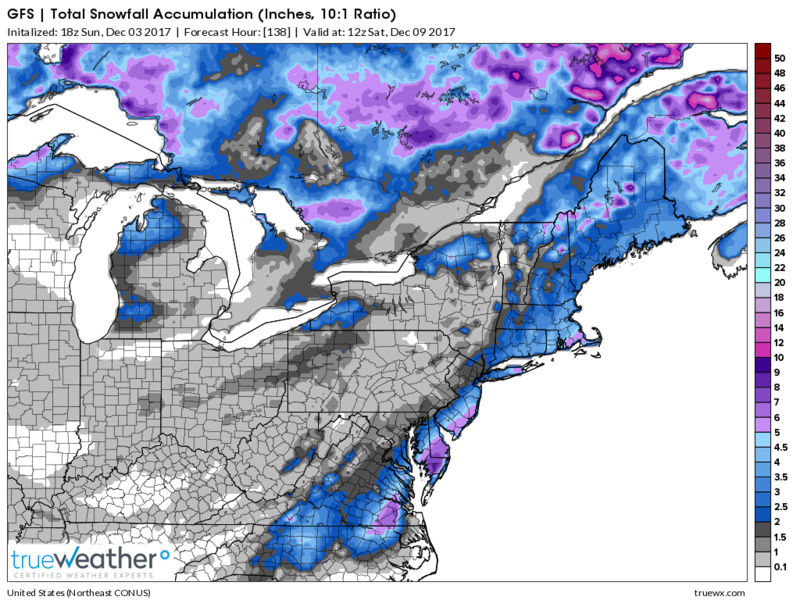
The 12z EURO today gives us snow from the coastal storm and the inverted trough.

Total snow amounts by Sunday morning

_________________
_______________________________________________________________________________________________________
CLICK HERE to view NJ Strong Snowstorm Classifications
Frank_Wx- Godzilla Seeker
- Posts : 21305
Reputation : 328
Join date : 2013-01-05
Age : 32
Location : Jersey City, NJ -
Re: Possible Snowstorm December 8th-9th
![]() by mikeypizano Sat Dec 02, 2017 2:25 pm
by mikeypizano Sat Dec 02, 2017 2:25 pm
mikeypizano- Pro Enthusiast
- Posts : 1118
Reputation : 66
Join date : 2017-01-05
Age : 35
Location : Wilkes-Barre/Scranton, PA
Re: Possible Snowstorm December 8th-9th
![]() by nutleyblizzard Sun Dec 03, 2017 7:35 am
by nutleyblizzard Sun Dec 03, 2017 7:35 am

nutleyblizzard- Senior Enthusiast

- Posts : 1954
Reputation : 41
Join date : 2014-01-30
Age : 58
Location : Nutley, new jersey
Re: Possible Snowstorm December 8th-9th
![]() by mikeypizano Sun Dec 03, 2017 7:36 am
by mikeypizano Sun Dec 03, 2017 7:36 am
mikeypizano- Pro Enthusiast
- Posts : 1118
Reputation : 66
Join date : 2017-01-05
Age : 35
Location : Wilkes-Barre/Scranton, PA
Re: Possible Snowstorm December 8th-9th
![]() by amugs Sun Dec 03, 2017 9:33 am
by amugs Sun Dec 03, 2017 9:33 am
As I stated in the LR thread the models will.come around to the pattern. Just have somw patience.
We have a the PV dropping into the Western Grear lakes and a LP that will round it's base and sharpen once it gets towads the coast. Lift will occur westward due tobtjis. It will snow!!! How much is anyone's guess at the juncture but the jets treat and RH maps support snow for a vast majority of our area next weekend.
_________________
Mugs
AKA:King: Snow Weenie
Self Proclaimed
WINTER 2014-15 : 55.12" +.02 for 6 coatings (avg. 35")
WINTER 2015-16 Total - 29.8" (Avg 35")
WINTER 2016-17 : 39.5" so far

amugs- Advanced Forecaster - Mod

- Posts : 15095
Reputation : 213
Join date : 2013-01-07
Age : 54
Location : Hillsdale,NJ
Re: Possible Snowstorm December 8th-9th
![]() by Frank_Wx Sun Dec 03, 2017 10:05 am
by Frank_Wx Sun Dec 03, 2017 10:05 am

_________________
_______________________________________________________________________________________________________
CLICK HERE to view NJ Strong Snowstorm Classifications
Frank_Wx- Godzilla Seeker
- Posts : 21305
Reputation : 328
Join date : 2013-01-05
Age : 32
Location : Jersey City, NJ -
Re: Possible Snowstorm December 8th-9th
![]() by track17 Sun Dec 03, 2017 10:17 am
by track17 Sun Dec 03, 2017 10:17 am
track17- Posts : 454
Reputation : 4
Join date : 2016-01-09
Re: Possible Snowstorm December 8th-9th
![]() by sroc4 Sun Dec 03, 2017 11:08 am
by sroc4 Sun Dec 03, 2017 11:08 am
_________________
"In weather and in life, there's no winning and losing; there's only winning and learning."
WINTER 2012/2013 TOTALS 43.65"WINTER 2017/2018 TOTALS 62.85" WINTER 2022/2023 TOTALS 4.9"
WINTER 2013/2014 TOTALS 64.85"WINTER 2018/2019 TOTALS 14.25" WINTER 2023/2024 TOTALS 13.1"
WINTER 2014/2015 TOTALS 71.20"WINTER 2019/2020 TOTALS 6.35"
WINTER 2015/2016 TOTALS 35.00"WINTER 2020/2021 TOTALS 37.75"
WINTER 2016/2017 TOTALS 42.25"WINTER 2021/2022 TOTALS 31.65"

sroc4- Admin
- Posts : 8354
Reputation : 302
Join date : 2013-01-07
Location : Wading River, LI
Re: Possible Snowstorm December 8th-9th
![]() by mikeypizano Sun Dec 03, 2017 4:35 pm
by mikeypizano Sun Dec 03, 2017 4:35 pm
mikeypizano- Pro Enthusiast
- Posts : 1118
Reputation : 66
Join date : 2017-01-05
Age : 35
Location : Wilkes-Barre/Scranton, PA
Re: Possible Snowstorm December 8th-9th
![]() by Snow88 Sun Dec 03, 2017 5:04 pm
by Snow88 Sun Dec 03, 2017 5:04 pm

Snow88- Senior Enthusiast
- Posts : 2193
Reputation : 4
Join date : 2013-01-09
Age : 35
Location : Brooklyn, NY
Re: Possible Snowstorm December 8th-9th
![]() by track17 Sun Dec 03, 2017 5:07 pm
by track17 Sun Dec 03, 2017 5:07 pm
track17- Posts : 454
Reputation : 4
Join date : 2016-01-09

skinsfan1177- Senior Enthusiast
- Posts : 4485
Reputation : 35
Join date : 2013-01-07
Age : 46
Location : Point Pleasant Boro
Re: Possible Snowstorm December 8th-9th
![]() by mikeypizano Sun Dec 03, 2017 5:53 pm
by mikeypizano Sun Dec 03, 2017 5:53 pm
mikeypizano- Pro Enthusiast
- Posts : 1118
Reputation : 66
Join date : 2017-01-05
Age : 35
Location : Wilkes-Barre/Scranton, PA
Re: Possible Snowstorm December 8th-9th
![]() by Snow88 Sun Dec 03, 2017 6:06 pm
by Snow88 Sun Dec 03, 2017 6:06 pm
mikeypizano wrote:Oh boy I may see a full inch!
It's only December
Snow88- Senior Enthusiast
- Posts : 2193
Reputation : 4
Join date : 2013-01-09
Age : 35
Location : Brooklyn, NY
Re: Possible Snowstorm December 8th-9th
![]() by mikeypizano Sun Dec 03, 2017 6:07 pm
by mikeypizano Sun Dec 03, 2017 6:07 pm
Snow88 wrote:mikeypizano wrote:Oh boy I may see a full inch!
It's only December
So? Whats your point?
mikeypizano- Pro Enthusiast
- Posts : 1118
Reputation : 66
Join date : 2017-01-05
Age : 35
Location : Wilkes-Barre/Scranton, PA
Re: Possible Snowstorm December 8th-9th
![]() by frank 638 Sun Dec 03, 2017 6:18 pm
by frank 638 Sun Dec 03, 2017 6:18 pm
frank 638- Senior Enthusiast
- Posts : 2843
Reputation : 37
Join date : 2016-01-01
Age : 40
Location : bronx ny
Re: Possible Snowstorm December 8th-9th
![]() by mikeypizano Sun Dec 03, 2017 6:25 pm
by mikeypizano Sun Dec 03, 2017 6:25 pm
frank 638 wrote:I know it's only 1 inch of snow but I am happy with that because after having two lousy December's with record highs. At least this December we are having a big turnaround with colder and stormy conditions I am hoping we will see more snow especially when we get into Christmas weak
Give me at least 2 inches and I will be happy. I still make some off an inch though.
mikeypizano- Pro Enthusiast
- Posts : 1118
Reputation : 66
Join date : 2017-01-05
Age : 35
Location : Wilkes-Barre/Scranton, PA
Re: Possible Snowstorm December 8th-9th
![]() by Snow88 Sun Dec 03, 2017 9:31 pm
by Snow88 Sun Dec 03, 2017 9:31 pm
mikeypizano wrote:Snow88 wrote:mikeypizano wrote:Oh boy I may see a full inch!
It's only December
So? Whats your point?
We dont get a lot of snow here in December
Snow88- Senior Enthusiast
- Posts : 2193
Reputation : 4
Join date : 2013-01-09
Age : 35
Location : Brooklyn, NY
Re: Possible Snowstorm December 8th-9th
![]() by mikeypizano Sun Dec 03, 2017 9:32 pm
by mikeypizano Sun Dec 03, 2017 9:32 pm
Snow88 wrote:mikeypizano wrote:Snow88 wrote:mikeypizano wrote:Oh boy I may see a full inch!
It's only December
So? Whats your point?
We dont get a lot of snow here in December
Dream big or go home right?
mikeypizano- Pro Enthusiast
- Posts : 1118
Reputation : 66
Join date : 2017-01-05
Age : 35
Location : Wilkes-Barre/Scranton, PA
Re: Possible Snowstorm December 8th-9th
![]() by rb924119 Mon Dec 04, 2017 8:42 am
by rb924119 Mon Dec 04, 2017 8:42 am
rb924119- Meteorologist

- Posts : 6928
Reputation : 194
Join date : 2013-02-06
Age : 32
Location : Greentown, Pa
Re: Possible Snowstorm December 8th-9th
![]() by hyde345 Mon Dec 04, 2017 8:58 am
by hyde345 Mon Dec 04, 2017 8:58 am
rb924119 wrote:Here come the EURO Ensembles for late week/this weekend......slow but steady, and I'm fine with that
I'm not sure what you're seeing but it looks like it's too far east for most of us.

hyde345- Pro Enthusiast
- Posts : 1082
Reputation : 48
Join date : 2013-01-08
Location : Hyde Park, NY
Re: Possible Snowstorm December 8th-9th
![]() by Frank_Wx Mon Dec 04, 2017 9:04 am
by Frank_Wx Mon Dec 04, 2017 9:04 am
hyde345 wrote:rb924119 wrote:Here come the EURO Ensembles for late week/this weekend......slow but steady, and I'm fine with that
I'm not sure what you're seeing but it looks like it's too far east for most of us.
The EURO Ensembles had a lot of members clustered near the BM. It gave I-95 and points east a couple inches of snow. We're inside 120 hours as of today, so model runs will become prudent. We'll see what happens
_________________
_______________________________________________________________________________________________________
CLICK HERE to view NJ Strong Snowstorm Classifications
Frank_Wx- Godzilla Seeker
- Posts : 21305
Reputation : 328
Join date : 2013-01-05
Age : 32
Location : Jersey City, NJ -
Page 1 of 15 • 1, 2, 3 ... 8 ... 15 ![]()
|
|
|