
 Search
Possible Snowstorm December 8th-9th
Page 2 of 15 •  1, 2, 3 ... 8 ... 15
 ![]()
Re: Possible Snowstorm December 8th-9th
![]() by hyde345 Mon Dec 04, 2017 8:58 am
by hyde345 Mon Dec 04, 2017 8:58 am
rb924119 wrote:Here come the EURO Ensembles for late week/this weekend......slow but steady, and I'm fine with that
I'm not sure what you're seeing but it looks like it's too far east for most of us.
hyde345- Pro Enthusiast

- Posts : 1082
Join date : 2013-01-08
Re: Possible Snowstorm December 8th-9th
![]() by Frank_Wx Mon Dec 04, 2017 9:04 am
by Frank_Wx Mon Dec 04, 2017 9:04 am
hyde345 wrote:rb924119 wrote:Here come the EURO Ensembles for late week/this weekend......slow but steady, and I'm fine with that
I'm not sure what you're seeing but it looks like it's too far east for most of us.
The EURO Ensembles had a lot of members clustered near the BM. It gave I-95 and points east a couple inches of snow. We're inside 120 hours as of today, so model runs will become prudent. We'll see what happens
Frank_Wx- Godzilla Seeker

- Posts : 21305
Join date : 2013-01-05 -

Re: Possible Snowstorm December 8th-9th
![]() by hyde345 Mon Dec 04, 2017 9:09 am
by hyde345 Mon Dec 04, 2017 9:09 am
Frank_Wx wrote:hyde345 wrote:rb924119 wrote:Here come the EURO Ensembles for late week/this weekend......slow but steady, and I'm fine with that
I'm not sure what you're seeing but it looks like it's too far east for most of us.
The EURO Ensembles had a lot of members clustered near the BM. It gave I-95 and points east a couple inches of snow. We're inside 120 hours as of today, so model runs will become prudent. We'll see what happens
OK, thanks. I don't get to see individual members.

hyde345- Pro Enthusiast
- Posts : 1082
Reputation : 48
Join date : 2013-01-08
Location : Hyde Park, NY
Re: Possible Snowstorm December 8th-9th
![]() by Frank_Wx Mon Dec 04, 2017 9:11 am
by Frank_Wx Mon Dec 04, 2017 9:11 am
hyde345 wrote:Frank_Wx wrote:hyde345 wrote:rb924119 wrote:Here come the EURO Ensembles for late week/this weekend......slow but steady, and I'm fine with that
I'm not sure what you're seeing but it looks like it's too far east for most of us.
The EURO Ensembles had a lot of members clustered near the BM. It gave I-95 and points east a couple inches of snow. We're inside 120 hours as of today, so model runs will become prudent. We'll see what happens
OK, thanks. I don't get to see individual members.


_________________
_______________________________________________________________________________________________________
CLICK HERE to view NJ Strong Snowstorm Classifications

Frank_Wx- Godzilla Seeker
- Posts : 21305
Reputation : 328
Join date : 2013-01-05
Age : 32
Location : Jersey City, NJ -
Re: Possible Snowstorm December 8th-9th
![]() by skinsfan1177 Mon Dec 04, 2017 9:19 am
by skinsfan1177 Mon Dec 04, 2017 9:19 am

skinsfan1177- Senior Enthusiast

- Posts : 4485
Reputation : 35
Join date : 2013-01-07
Age : 46
Location : Point Pleasant Boro
Re: Possible Snowstorm December 8th-9th
![]() by sroc4 Mon Dec 04, 2017 9:24 am
by sroc4 Mon Dec 04, 2017 9:24 am
Frank_Wx wrote:hyde345 wrote:Frank_Wx wrote:hyde345 wrote:rb924119 wrote:Here come the EURO Ensembles for late week/this weekend......slow but steady, and I'm fine with that
I'm not sure what you're seeing but it looks like it's too far east for most of us.
The EURO Ensembles had a lot of members clustered near the BM. It gave I-95 and points east a couple inches of snow. We're inside 120 hours as of today, so model runs will become prudent. We'll see what happens
OK, thanks. I don't get to see individual members.
And here are the individual members current snow totals. Most of this on these members comes in for the 9th-10th. Like mentioned above we are in the MR where we can start looking to focus the details. The only thing to really look at with these images below is what percent show accumulation vs dry, and what are the trends over the next 3-4days. Do we see more and more members jumping on board the accumulation train or not? Etc...


_________________
"In weather and in life, there's no winning and losing; there's only winning and learning."
WINTER 2012/2013 TOTALS 43.65"WINTER 2017/2018 TOTALS 62.85" WINTER 2022/2023 TOTALS 4.9"
WINTER 2013/2014 TOTALS 64.85"WINTER 2018/2019 TOTALS 14.25" WINTER 2023/2024 TOTALS 13.1"
WINTER 2014/2015 TOTALS 71.20"WINTER 2019/2020 TOTALS 6.35"
WINTER 2015/2016 TOTALS 35.00"WINTER 2020/2021 TOTALS 37.75"
WINTER 2016/2017 TOTALS 42.25"WINTER 2021/2022 TOTALS 31.65"

sroc4- Admin
- Posts : 8354
Reputation : 302
Join date : 2013-01-07
Location : Wading River, LI
Re: Possible Snowstorm December 8th-9th
![]() by amugs Mon Dec 04, 2017 9:46 am
by amugs Mon Dec 04, 2017 9:46 am

Flow maybe a bit to progressive and need this to dig a bit more SW not sow much SE or else we push this to far off the coast. We'll know more in teh next 24 - 36hours
_________________
Mugs
AKA:King: Snow Weenie
Self Proclaimed
WINTER 2014-15 : 55.12" +.02 for 6 coatings (avg. 35")
WINTER 2015-16 Total - 29.8" (Avg 35")
WINTER 2016-17 : 39.5" so far

amugs- Advanced Forecaster - Mod

- Posts : 15095
Reputation : 213
Join date : 2013-01-07
Age : 54
Location : Hillsdale,NJ
Re: Possible Snowstorm December 8th-9th
![]() by Guest Mon Dec 04, 2017 9:57 am
by Guest Mon Dec 04, 2017 9:57 am
Guest- Guest
Re: Possible Snowstorm December 8th-9th
![]() by sroc4 Mon Dec 04, 2017 1:13 pm
by sroc4 Mon Dec 04, 2017 1:13 pm
TheAresian wrote:What possible effect(s) does the system in the Great Lakes have on the coastal system?
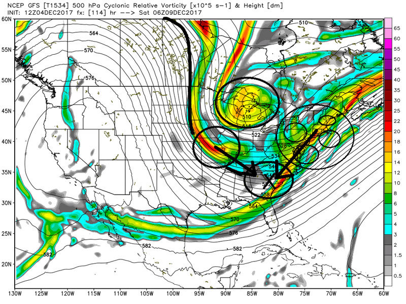
So I'm not sure if your looking at the cluster of LP on the EPS image Frank posted above but take a look at the 12z GFS from today. At about hr 114 you can see over the GL is a lobe of the PV that has a bunch of vorticity swirling around its center. In addition a strong s/w (shortwave) with its associated vorticity is also diving in on the back side of the polar jet and mean trough. On the surface this leads to weak areas of LP in and around the GL region out ahead of the vorticity in these locations. At the same time we have a progressive flow off the east coast which is leading to the vorticity along the main fontal boundary to remain elongated and strung out preventing the polar jet and STJ from phasing. With the progressive flow off the EC if the timing of a digging s/w into the back side of the trough is not perfect with energy in the STj then you cant raise hieghts out ahead which would bring the LP up the coast and stronger instead of weaker and strung out like we see currently modeled. In addition to the 500mb and the surface maps there are also the 200-300mb jet streak to account for in this set up. If we can get the fontal boundary to stall a little closer to the coast than was modeled on this run verbatim the upper level jet streak could allow the precip shield to expand further NW into the area than what we see here, but I don't have time to elaborate on these details now. Bottom line pattern suggests a progressive flow off the EC for this time frame meaning don't bet on a deepening coastal being the main idea here. There would likely be isolated areas of surface convergence between the GL and the coast due to so many areas of LP around the area such that the IVT snowfall could occur but this will be hard to predict. The best chance for a more wide spread mild to mod event will be related to how have south the frontal bourdary stalls and where the 300-200mb jet streak is positioned and a hopefully more expansive precip shiled related to those dynamics as well as some baroclinically enhanced lifting mechanisms.


_________________
"In weather and in life, there's no winning and losing; there's only winning and learning."
WINTER 2012/2013 TOTALS 43.65"WINTER 2017/2018 TOTALS 62.85" WINTER 2022/2023 TOTALS 4.9"
WINTER 2013/2014 TOTALS 64.85"WINTER 2018/2019 TOTALS 14.25" WINTER 2023/2024 TOTALS 13.1"
WINTER 2014/2015 TOTALS 71.20"WINTER 2019/2020 TOTALS 6.35"
WINTER 2015/2016 TOTALS 35.00"WINTER 2020/2021 TOTALS 37.75"
WINTER 2016/2017 TOTALS 42.25"WINTER 2021/2022 TOTALS 31.65"
sroc4- Admin
- Posts : 8354
Reputation : 302
Join date : 2013-01-07
Location : Wading River, LI
Re: Possible Snowstorm December 8th-9th
![]() by sroc4 Mon Dec 04, 2017 1:19 pm
by sroc4 Mon Dec 04, 2017 1:19 pm
_________________
"In weather and in life, there's no winning and losing; there's only winning and learning."
WINTER 2012/2013 TOTALS 43.65"WINTER 2017/2018 TOTALS 62.85" WINTER 2022/2023 TOTALS 4.9"
WINTER 2013/2014 TOTALS 64.85"WINTER 2018/2019 TOTALS 14.25" WINTER 2023/2024 TOTALS 13.1"
WINTER 2014/2015 TOTALS 71.20"WINTER 2019/2020 TOTALS 6.35"
WINTER 2015/2016 TOTALS 35.00"WINTER 2020/2021 TOTALS 37.75"
WINTER 2016/2017 TOTALS 42.25"WINTER 2021/2022 TOTALS 31.65"
sroc4- Admin
- Posts : 8354
Reputation : 302
Join date : 2013-01-07
Location : Wading River, LI
Re: Possible Snowstorm December 8th-9th
![]() by Frank_Wx Mon Dec 04, 2017 1:23 pm
by Frank_Wx Mon Dec 04, 2017 1:23 pm
_________________
_______________________________________________________________________________________________________
CLICK HERE to view NJ Strong Snowstorm Classifications
Frank_Wx- Godzilla Seeker
- Posts : 21305
Reputation : 328
Join date : 2013-01-05
Age : 32
Location : Jersey City, NJ -
Re: Possible Snowstorm December 8th-9th
![]() by Frank_Wx Mon Dec 04, 2017 1:25 pm
by Frank_Wx Mon Dec 04, 2017 1:25 pm
_________________
_______________________________________________________________________________________________________
CLICK HERE to view NJ Strong Snowstorm Classifications
Frank_Wx- Godzilla Seeker
- Posts : 21305
Reputation : 328
Join date : 2013-01-05
Age : 32
Location : Jersey City, NJ -
Re: Possible Snowstorm December 8th-9th
![]() by weatherwatchermom Mon Dec 04, 2017 1:32 pm
by weatherwatchermom Mon Dec 04, 2017 1:32 pm

weatherwatchermom- Senior Enthusiast
- Posts : 3793
Reputation : 78
Join date : 2014-11-25
Location : Hazlet Township, NJ
Re: Possible Snowstorm December 8th-9th
![]() by Frank_Wx Mon Dec 04, 2017 1:53 pm
by Frank_Wx Mon Dec 04, 2017 1:53 pm


Total snow from both waves

_________________
_______________________________________________________________________________________________________
CLICK HERE to view NJ Strong Snowstorm Classifications
Frank_Wx- Godzilla Seeker
- Posts : 21305
Reputation : 328
Join date : 2013-01-05
Age : 32
Location : Jersey City, NJ -
Re: Possible Snowstorm December 8th-9th
![]() by sroc4 Mon Dec 04, 2017 1:57 pm
by sroc4 Mon Dec 04, 2017 1:57 pm
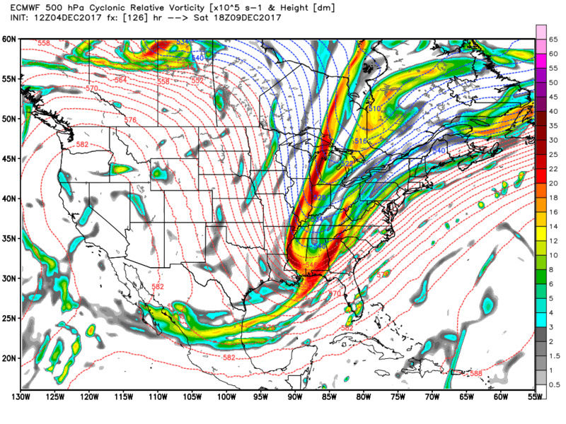
sroc4 wrote:Hypothetically speaking if we could get all the energy in the NE (all the yellow and reds) more consolidated further back S and W where I marked X and the timing of the back side s/w stayed the same then you would have a MUCH greater chance at a phase given the timing here which would raise heights out ahead of it and a much deeper LP would develop and head more NNE then remain strung out and head ENE. Timing and location is everything
And like that the euro shows exactly what I was saying. Notice there is less energy over the NE and more in the base of the trough

_________________
"In weather and in life, there's no winning and losing; there's only winning and learning."
WINTER 2012/2013 TOTALS 43.65"WINTER 2017/2018 TOTALS 62.85" WINTER 2022/2023 TOTALS 4.9"
WINTER 2013/2014 TOTALS 64.85"WINTER 2018/2019 TOTALS 14.25" WINTER 2023/2024 TOTALS 13.1"
WINTER 2014/2015 TOTALS 71.20"WINTER 2019/2020 TOTALS 6.35"
WINTER 2015/2016 TOTALS 35.00"WINTER 2020/2021 TOTALS 37.75"
WINTER 2016/2017 TOTALS 42.25"WINTER 2021/2022 TOTALS 31.65"
sroc4- Admin
- Posts : 8354
Reputation : 302
Join date : 2013-01-07
Location : Wading River, LI
Re: Possible Snowstorm December 8th-9th
![]() by Frank_Wx Tue Dec 05, 2017 6:04 am
by Frank_Wx Tue Dec 05, 2017 6:04 am
_________________
_______________________________________________________________________________________________________
CLICK HERE to view NJ Strong Snowstorm Classifications
Frank_Wx- Godzilla Seeker
- Posts : 21305
Reputation : 328
Join date : 2013-01-05
Age : 32
Location : Jersey City, NJ -
Re: Possible Snowstorm December 8th-9th
![]() by Radz Tue Dec 05, 2017 6:57 am
by Radz Tue Dec 05, 2017 6:57 am
Frank_Wx wrote:Overnight models were not impressed. GFS has some light snow for NYC and LI late Friday while the EURO showed nothing. It looks like there are too many waves in the pattern and that is preventing an organized storm from developing. Doesn't help that the flow looks progressive too. Don't bank on much at the moment.
Hoping for some mood flakes this weekend at least, if this threat doesn't pan out, maybe midweek will deliver...

Radz- Pro Enthusiast
- Posts : 1028
Reputation : 17
Join date : 2013-01-12
Location : Cortlandt Manor NY
Re: Possible Snowstorm December 8th-9th
![]() by skinsfan1177 Tue Dec 05, 2017 8:55 am
by skinsfan1177 Tue Dec 05, 2017 8:55 am
skinsfan1177- Senior Enthusiast
- Posts : 4485
Reputation : 35
Join date : 2013-01-07
Age : 46
Location : Point Pleasant Boro
Re: Possible Snowstorm December 8th-9th
![]() by Frank_Wx Tue Dec 05, 2017 9:17 am
by Frank_Wx Tue Dec 05, 2017 9:17 am

_________________
_______________________________________________________________________________________________________
CLICK HERE to view NJ Strong Snowstorm Classifications
Frank_Wx- Godzilla Seeker
- Posts : 21305
Reputation : 328
Join date : 2013-01-05
Age : 32
Location : Jersey City, NJ -
Re: Possible Snowstorm December 8th-9th
![]() by MattyICE Tue Dec 05, 2017 9:39 am
by MattyICE Tue Dec 05, 2017 9:39 am
MattyICE- Advanced Forecaster

- Posts : 249
Reputation : 6
Join date : 2017-11-10
Age : 38
Location : Clifton, NJ (Eastern Passaic County)
Re: Possible Snowstorm December 8th-9th
![]() by skinsfan1177 Tue Dec 05, 2017 9:42 am
by skinsfan1177 Tue Dec 05, 2017 9:42 am
skinsfan1177- Senior Enthusiast
- Posts : 4485
Reputation : 35
Join date : 2013-01-07
Age : 46
Location : Point Pleasant Boro
Re: Possible Snowstorm December 8th-9th
![]() by rb924119 Tue Dec 05, 2017 9:47 am
by rb924119 Tue Dec 05, 2017 9:47 am
skinsfan1177 wrote:I still have hope in this system. We are days away anything can change. Hoping for positive trends today
I am NOT giving up hope on this system AT ALL. I feel strongly that we, or at least some of us, will end up seeing an accumulating snowfall from this system. As you stated below, the northern stream energy will not be well-sampled until late-week, and if my memory serves me correctly, modeling tends to significantly under-represent the strength and speed of energy in setups where the PV is displaced so far south and the energy is truly coming directly from the Arctic. I could be wrong, but pattern recognition argues for an East Coast storm, and with guidance a mere 50 miles too far east right now, I see no reason to abandon my ship.....yet lol
rb924119- Meteorologist

- Posts : 6928
Reputation : 194
Join date : 2013-02-06
Age : 32
Location : Greentown, Pa
Re: Possible Snowstorm December 8th-9th
![]() by rb924119 Tue Dec 05, 2017 9:48 am
by rb924119 Tue Dec 05, 2017 9:48 am
rb924119- Meteorologist
- Posts : 6928
Reputation : 194
Join date : 2013-02-06
Age : 32
Location : Greentown, Pa
Re: Possible Snowstorm December 8th-9th
![]() by crippo84 Tue Dec 05, 2017 9:58 am
by crippo84 Tue Dec 05, 2017 9:58 am
rb924119 wrote:MY GOD HERE COMES THE NAM
Please...do share the news lol.

crippo84- Posts : 383
Reputation : 20
Join date : 2013-11-07
Age : 40
Location : East Village, NYC
Re: Possible Snowstorm December 8th-9th
![]() by sroc4 Tue Dec 05, 2017 10:23 am
by sroc4 Tue Dec 05, 2017 10:23 am
rb924119 wrote:MY GOD HERE COMES THE NAM
Its so funny you say this because I just came home frm running errands and saw what time it was. I was like is it GFS time yet?? Nope but the NAM probably ran. Lts just take a gander at it. 500mb is very interesting to say the least. Of course its the NAM at the end of its run but interesting none the less.

_________________
"In weather and in life, there's no winning and losing; there's only winning and learning."
WINTER 2012/2013 TOTALS 43.65"WINTER 2017/2018 TOTALS 62.85" WINTER 2022/2023 TOTALS 4.9"
WINTER 2013/2014 TOTALS 64.85"WINTER 2018/2019 TOTALS 14.25" WINTER 2023/2024 TOTALS 13.1"
WINTER 2014/2015 TOTALS 71.20"WINTER 2019/2020 TOTALS 6.35"
WINTER 2015/2016 TOTALS 35.00"WINTER 2020/2021 TOTALS 37.75"
WINTER 2016/2017 TOTALS 42.25"WINTER 2021/2022 TOTALS 31.65"
sroc4- Admin
- Posts : 8354
Reputation : 302
Join date : 2013-01-07
Location : Wading River, LI
Re: Possible Snowstorm December 8th-9th
![]() by rb924119 Tue Dec 05, 2017 10:33 am
by rb924119 Tue Dec 05, 2017 10:33 am
crippo84 wrote:rb924119 wrote:MY GOD HERE COMES THE NAM
Please...do share the news lol.
Take a look at the below two images both valid 00Z Saturday:
GFS:
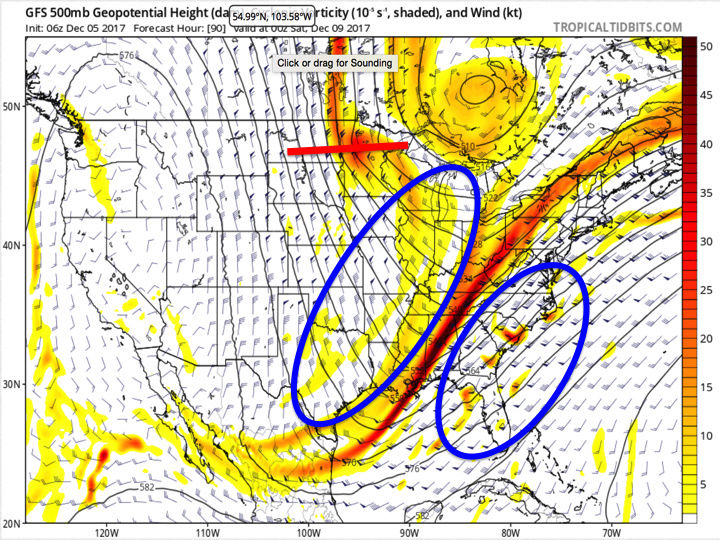
The northern stream energy diving down the southwestern flank of the mid-tropospheric PV is denoted by the red line through Minnesota. Note the extremely positive orientation of it compared to the much less positively tilted axis of the longer-wave trough centered through the eastern U.S., as well as the large amount of distance between the two. Also note the two blue ovals on either side of the larger-scale trough - they are there to highlight the wind barbs and forecasted strength/direction of the winds at this level. Notice how none of the barbs in the western oval are above 50 knots, while in the eastern one there are several well over 100 knots.
Compare that with the most recent NAM run valid for the same time:
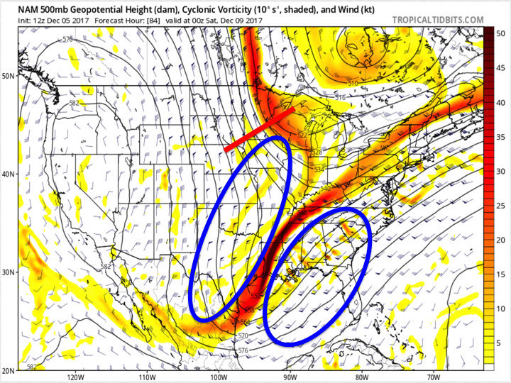
Notice the significant differences in the northern stream energy with respect to both strength, location, and orientation. Also note the differences in the strength and orientation of the forecasted winds ahead of and behind the larger-scale trough. The reason why the GFS is so strung out is because the northern stream energy has no way of catching up to the energy in the larger trough. Why? The winds out ahead of it slow down markedly while the winds ahead of the larger trough are significantly faster, thus "dragging" the energy in the main trough out so fast that it can't organize at all. The NAM, however, does NOT decelerate the winds ahead of the northern stream nearly as much which would allow it to progress much more quickly around the base of the PV. It's orientation is also very important because the closer the two trough axes are in alignment, the closer to a phase they are. Secondly, because the winds ahead of the northern stream energy/behind the main trough are not decelerating nearly as much AND they are also directed from due north to south, or even slightly north-northeast to south-southwest in conjunction with the winds being noticeably slower ahead of the main trough compared to the GFS, this allows the energy in the main trough to continue to dig further south AND consolidate some. Why does this matter? It will slow the main energy down and allow the northern stream energy to begin to really close the gap. It will also the heights ahead of the whole system to begin rising more than the GFS, which would direct the steering flow toward a more south to north direction instead of a west-southwest direction.
Unfortunately I don't time to go much further, but hopefully that makes sense.
rb924119- Meteorologist
- Posts : 6928
Reputation : 194
Join date : 2013-02-06
Age : 32
Location : Greentown, Pa

jake732- Pro Enthusiast
- Posts : 449
Reputation : 0
Join date : 2016-01-03
Location : lakewood, nj -
Page 2 of 15 • 1, 2, 3 ... 8 ... 15 ![]()
|
|
|