
 Search
Long Range Thread 16.0
Page 35 of 40 •  1 ... 19 ... 34, 35, 36 ... 40
 ![]()
Re: Long Range Thread 16.0
![]() by CPcantmeasuresnow Wed Jan 31, 2018 12:14 am
by CPcantmeasuresnow Wed Jan 31, 2018 12:14 am
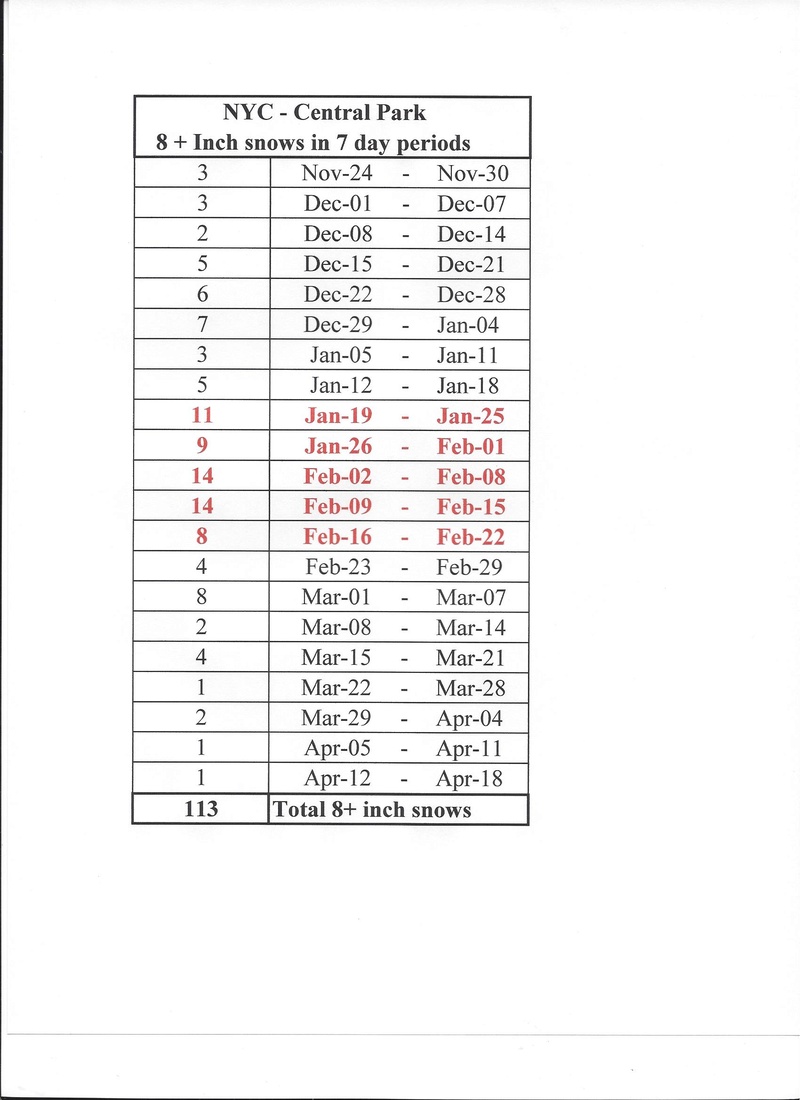
As you can see from the above the 5 week period from late January through most of February is a prime time in NYC for 8+ inch snows. but the 2nd through 15th is prime time. Let's hope history repeats itself.
CPcantmeasuresnow- Wx Statistician Guru

- Posts : 7274
Join date : 2013-01-07
Re: Long Range Thread 16.0
![]() by sroc4 Wed Jan 31, 2018 6:23 am
by sroc4 Wed Jan 31, 2018 6:23 am

sroc4- Admin

- Posts : 8331
Join date : 2013-01-07
Re: Long Range Thread 16.0
![]() by Guest Thu Feb 01, 2018 7:58 am
by Guest Thu Feb 01, 2018 7:58 am
Guest- Guest
Re: Long Range Thread 16.0
![]() by Guest Thu Feb 01, 2018 9:23 am
by Guest Thu Feb 01, 2018 9:23 am
Guest- Guest
Re: Long Range Thread 16.0
![]() by crippo84 Thu Feb 01, 2018 9:33 am
by crippo84 Thu Feb 01, 2018 9:33 am
syosnow94 wrote:After I made my post I checked in at another weather forum I lurk on occasionally just like CP does. They are all posting about how the current phase 6 MJO is in record strong territory and therefore will delay the transition to phase 8. The result is coastal runners and cutters for the next two weeks. It literally is the scientific explanation of what I posted before I even read it. Ironic!
This would align with Math's President's Day weekend prediction of the ideal pattern change

crippo84- Posts : 383
Reputation : 20
Join date : 2013-11-07
Age : 40
Location : East Village, NYC
Re: Long Range Thread 16.0
![]() by rb924119 Thu Feb 01, 2018 11:38 am
by rb924119 Thu Feb 01, 2018 11:38 am
syosnow94 wrote:I’m not as knowledgeable scientifically as some on here, but I think I know enough that I may have noticed something in the models that is a bit disconcerting. If you look at the position of the PV in my opinion it’s a little too far west to have a good storm track for us. I believe the short waves that rotate around it have too much time to round the base and therefore hug the coast putting us on the warm/mix side of things for the next few weeks. I think this upcoming pattern benefits areas from rat 81 areas west to the Great Lakes. [b]this is not just me reacting to the forecast for Sunday/Monday. This is an observation. Thoughts[/b]
The true pattern change was not expected to occur until the 7th-10th anyway, at least in my opinion, which would pretty well match that. We are now seeing signs of this as the MJO is now entering Phase 7, and the SOI IS NOW BEGINNING TO CRASH AGAINST THE BASE STATE. Seven to ten days from now, the effects from the MJO's progression into the second half of Phase 7 and the SOI crash will be seen here in the form of our true pattern change and troughing over the East
rb924119- Meteorologist

- Posts : 6889
Reputation : 194
Join date : 2013-02-06
Age : 32
Location : Greentown, Pa
Re: Long Range Thread 16.0
![]() by Guest Thu Feb 01, 2018 3:08 pm
by Guest Thu Feb 01, 2018 3:08 pm
rb924119 wrote:syosnow94 wrote:I’m not as knowledgeable scientifically as some on here, but I think I know enough that I may have noticed something in the models that is a bit disconcerting. If you look at the position of the PV in my opinion it’s a little too far west to have a good storm track for us. I believe the short waves that rotate around it have too much time to round the base and therefore hug the coast putting us on the warm/mix side of things for the next few weeks. I think this upcoming pattern benefits areas from rat 81 areas west to the Great Lakes. [b]this is not just me reacting to the forecast for Sunday/Monday. This is an observation. Thoughts[/b]
The true pattern change was not expected to occur until the 7th-10th anyway, at least in my opinion, which would pretty well match that. We are now seeing signs of this as the MJO is now entering Phase 7, and the SOI IS NOW BEGINNING TO CRASH AGAINST THE BASE STATE. Seven to ten days from now, the effects from the MJO's progression into the second half of Phase 7 and the SOI crash will be seen here in the form of our true pattern change and troughing over the Easttake a deep breath, and relaxxxxxxxx. Don't worry, be happy.
Thanks for trying to give me confidence but after enduring a two week torch and hearing about February producing and then seeing two big rain storms forecast for the first week I’m not having any of it. Sucks. Period. (This is where Amugs bans me for complaining
Guest- Guest
Re: Long Range Thread 16.0
![]() by amugs Thu Feb 01, 2018 3:38 pm
by amugs Thu Feb 01, 2018 3:38 pm
syosnow94 wrote:rb924119 wrote:syosnow94 wrote:I’m not as knowledgeable scientifically as some on here, but I think I know enough that I may have noticed something in the models that is a bit disconcerting. If you look at the position of the PV in my opinion it’s a little too far west to have a good storm track for us. I believe the short waves that rotate around it have too much time to round the base and therefore hug the coast putting us on the warm/mix side of things for the next few weeks. I think this upcoming pattern benefits areas from rat 81 areas west to the Great Lakes. [b]this is not just me reacting to the forecast for Sunday/Monday. This is an observation. Thoughts[/b]
The true pattern change was not expected to occur until the 7th-10th anyway, at least in my opinion, which would pretty well match that. We are now seeing signs of this as the MJO is now entering Phase 7, and the SOI IS NOW BEGINNING TO CRASH AGAINST THE BASE STATE. Seven to ten days from now, the effects from the MJO's progression into the second half of Phase 7 and the SOI crash will be seen here in the form of our true pattern change and troughing over the East
Thanks for trying to give me confidence but after enduring a two week torch and hearing about February producing and then seeing two big rain storms forecast for the first week I’m not having any of it. Sucks. Period. (This is where Amugs bans me for complaining)
No just go into hibernation out there on the snow capitol of the NE region and see you next winter. Simple.
_________________
Mugs
AKA:King: Snow Weenie
Self Proclaimed
WINTER 2014-15 : 55.12" +.02 for 6 coatings (avg. 35")
WINTER 2015-16 Total - 29.8" (Avg 35")
WINTER 2016-17 : 39.5" so far

amugs- Advanced Forecaster - Mod

- Posts : 15093
Reputation : 213
Join date : 2013-01-07
Age : 54
Location : Hillsdale,NJ
Re: Long Range Thread 16.0
![]() by Snow88 Thu Feb 01, 2018 5:38 pm
by Snow88 Thu Feb 01, 2018 5:38 pm
http://www.cpc.ncep.noaa.gov/products/precip/CWlink/daily_ao_index/ao.shtml
PNA looks good
http://www.cpc.ncep.noaa.gov/products/precip/CWlink/pna/pna.shtml

Snow88- Senior Enthusiast

- Posts : 2193
Reputation : 4
Join date : 2013-01-09
Age : 35
Location : Brooklyn, NY
Re: Long Range Thread 16.0
![]() by amugs Thu Feb 01, 2018 10:14 pm
by amugs Thu Feb 01, 2018 10:14 pm
Math got a hold of them LOL!!
_________________
Mugs
AKA:King: Snow Weenie
Self Proclaimed
WINTER 2014-15 : 55.12" +.02 for 6 coatings (avg. 35")
WINTER 2015-16 Total - 29.8" (Avg 35")
WINTER 2016-17 : 39.5" so far
amugs- Advanced Forecaster - Mod
- Posts : 15093
Reputation : 213
Join date : 2013-01-07
Age : 54
Location : Hillsdale,NJ
Re: Long Range Thread 16.0
![]() by CPcantmeasuresnow Thu Feb 01, 2018 10:21 pm
by CPcantmeasuresnow Thu Feb 01, 2018 10:21 pm
Snow88 wrote:AO is freefalling
http://www.cpc.ncep.noaa.gov/products/precip/CWlink/daily_ao_index/ao.shtml
PNA looks good
http://www.cpc.ncep.noaa.gov/products/precip/CWlink/pna/pna.shtml
Speaking of Free Falling.
https://youtu.be/1lWJXDG2i0A

CPcantmeasuresnow- Wx Statistician Guru
- Posts : 7274
Reputation : 230
Join date : 2013-01-07
Age : 103
Location : Eastern Orange County, NY
Re: Long Range Thread 16.0
![]() by docstox12 Fri Feb 02, 2018 5:24 am
by docstox12 Fri Feb 02, 2018 5:24 am
CPcantmeasuresnow wrote:Snow88 wrote:AO is freefalling
http://www.cpc.ncep.noaa.gov/products/precip/CWlink/daily_ao_index/ao.shtml
PNA looks good
http://www.cpc.ncep.noaa.gov/products/precip/CWlink/pna/pna.shtml
Speaking of Free Falling.
https://youtu.be/1lWJXDG2i0A
CP, my favorite Tom Petty song.I remember that vid on MTV.Remember the early 80's when MTV hit the air,LOL.Classic stuff!!!!
Hope the song translates into teleconnections that bring an area wide blockbuster blizzard here so EVERYBODY in our broadcast area can enjoy it !

docstox12- Wx Statistician Guru
- Posts : 8502
Reputation : 222
Join date : 2013-01-07
Age : 73
Location : Monroe NY
Re: Long Range Thread 16.0
![]() by Guest Fri Feb 02, 2018 6:21 am
by Guest Fri Feb 02, 2018 6:21 am
Guest- Guest
Re: Long Range Thread 16.0
![]() by docstox12 Fri Feb 02, 2018 6:43 am
by docstox12 Fri Feb 02, 2018 6:43 am
syosnow94 wrote:Doc I hope you’re right, but man have I become pessimistic in the last 24 hours. I can’t complain being that I’m already at my normal winter snowfall here after January on the coast. But man with all the hype for a blockbuster cold and very snowy February now turning into rainstorm after rainstorm and according to some guidance, warm weather returning around Valentines I’m starting to get really worried that this may be it. Until I see Frank change the scroll I’ll hold out hope but doesn’t look good
Jimmy, up here I'm thinking I have a good shot at some snow Sunday-Monday being colder and more elevation.I am always optimistic but from my ancient memory comes the 1960-1961 winter with 3 major snowstorms and days of subfreezing cold from early December to early February.Then, the obligatory reversion to the mean happened and after the February 3-4 1961 snowstorm, it turned warmer with barely any snow for the rest of that winter.Hope that does not happen this year.It just seems this year the pattern can't get into something that can produce a major snowstorm area wide.The long range crew is optimistic!!Be thankful you got the 16 inch and the surprise snow the other day!!!
docstox12- Wx Statistician Guru
- Posts : 8502
Reputation : 222
Join date : 2013-01-07
Age : 73
Location : Monroe NY
Re: Long Range Thread 16.0
![]() by Frank_Wx Fri Feb 02, 2018 7:58 am
by Frank_Wx Fri Feb 02, 2018 7:58 am
_________________
_______________________________________________________________________________________________________
CLICK HERE to view NJ Strong Snowstorm Classifications

Frank_Wx- Godzilla Seeker
- Posts : 21305
Reputation : 328
Join date : 2013-01-05
Age : 31
Location : Jersey City, NJ -

Re: Long Range Thread 16.0
![]() by rb924119 Fri Feb 02, 2018 8:20 am
by rb924119 Fri Feb 02, 2018 8:20 am
rb924119- Meteorologist
- Posts : 6889
Reputation : 194
Join date : 2013-02-06
Age : 32
Location : Greentown, Pa
Re: Long Range Thread 16.0
![]() by amugs Fri Feb 02, 2018 8:20 am
by amugs Fri Feb 02, 2018 8:20 am
Frank_Wx wrote:Do not give up on February. Between a VERY active MJO and Strat warming, models are going to struggle big time. You will see huge changes run to run. I did not expect February to look great until around the 6th anyway. We'll see what happens.
IFWT!!!!!!
IN FRANK WE TRUST!!!!!!!!
Where was this a month ago??

_________________
Mugs
AKA:King: Snow Weenie
Self Proclaimed
WINTER 2014-15 : 55.12" +.02 for 6 coatings (avg. 35")
WINTER 2015-16 Total - 29.8" (Avg 35")
WINTER 2016-17 : 39.5" so far
amugs- Advanced Forecaster - Mod
- Posts : 15093
Reputation : 213
Join date : 2013-01-07
Age : 54
Location : Hillsdale,NJ
Re: Long Range Thread 16.0
![]() by sroc4 Fri Feb 02, 2018 8:22 am
by sroc4 Fri Feb 02, 2018 8:22 am

I will admit I personally underestimated just how potent the MJO pulse was going to be as it rounded 5 into 6 then eventually 7 (GFS def led the way there), and its overall effects it is having on the pattern. We are still in warm phases yet we really haven't been that warm. 37-40* along the coast is hardley warm. The trop forcing is leading to a set up such that even though we have the Trop PV displaced south towards the H Bay it is a broad based long wave trough rather than a sharp trough digging into the CONUS and interacting more with the Pac and/or ST Jet. Even though our EPO is headed negative over the next few days the ridge axis out west is shifted a tad too far off the WC of NA. The PNA remains neg so we have a more zonal flow off the SW CONUS and the +NAO is keeping a progressive flow off the EC. All of this equates to what?

The Polar jet will be sending spokes of arctic s/w southward while the Pac jet will be sending s/w entering the NW CONUS/WC Canada diving underneath. Because overall we don't have a great PNA ridge in the W CONUS and because we have a progressive flow off the EC we have a set up that will all be about timing. If we have an amplified Pac s/w and or an interaction between polar s/w and Pac s/w too early we will likely get the system to hug the coast and or be an apps runner as there is no real mechanism to push the system east off the coast first before coming up. That said this could also lead to initial over running events with the cold air in place followed by change over/mixing due to the SW flow out ahead of our systems, esp along the coastal plain, before returning the cold as the system passes by. I know this is not a "great" pattern, and some may not even call it a "good" pattern, but again Love is in the eye of the beholder. With so much cold air just to the north IMHO this is a good pattern in that it offers snow chances if the timing is right. With so much energy in the upper level we will likely not see the final solns in modeling until inside 2-3 days at best with most if not all of these chances. God grant me the serenity to accept the things I can not change. It is what it is folks. Accept it and embrace it. Beyond mid month there are rumblings of the pattern breaking down and getting worse. Hold the phone on that one. With the MJO forecasted to weaken drastically, the SOI forecasted to flip from strong positive to neg (which it already has--"cattle prod to the atmosphere") https://www.longpaddock.qld.gov.au/seasonalclimateoutlook/southernoscillationindex/30daysoivalues/, and with major disruption to the start PV on the way the LR pattern is anything but a lock. Models will likely go into their typical chaos mode until we get closer.

_________________
"In weather and in life, there's no winning and losing; there's only winning and learning."
WINTER 2012/2013 TOTALS 43.65"WINTER 2017/2018 TOTALS 62.85" WINTER 2022/2023 TOTALS 4.9"
WINTER 2013/2014 TOTALS 64.85"WINTER 2018/2019 TOTALS 14.25" WINTER 2023/2024 TOTALS 13.1"
WINTER 2014/2015 TOTALS 71.20"WINTER 2019/2020 TOTALS 6.35"
WINTER 2015/2016 TOTALS 35.00"WINTER 2020/2021 TOTALS 37.75"
WINTER 2016/2017 TOTALS 42.25"WINTER 2021/2022 TOTALS 31.65"

sroc4- Admin
- Posts : 8331
Reputation : 301
Join date : 2013-01-07
Location : Wading River, LI
Re: Long Range Thread 16.0
![]() by sroc4 Fri Feb 02, 2018 8:27 am
by sroc4 Fri Feb 02, 2018 8:27 am
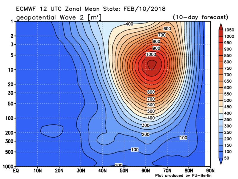
Earth light:
The stratosphere is set to undergo a disruption now over the next 7 to 14 days and it is becoming increasingly possible that this will be a significant event. The ECMWF, GFS and GEFS are forecasting a tremendous Wave 2 anomaly and a complete split of the stratospheric polar vortex at multiple levels. We have seen a sudden jump to this idea on the latest forecast model guidance and it is especially impressive to see this depiction on the GFS and GEFS guidance. The GEFS members all forecast a complete zonal wind reversal and the large piece of the stratospheric polar vortex breaks off over North America.
This could potentially be related to the impressive and record breaking Phase 7 MJO, as suggested by Wheeler/Hendon et al 2004, where warmer anomalies on the lower polar stratosphere can suddenly and rapidly develop as a result of constructive interference between mid latitude circulations and anomalous convection in the tropical regions of the Pacific Ocean.
The latest observations and model guidance show a well coupled troposphere/stratospheric wave relationship through the tropopause. It appears increasingly possible to me that we will see a significant disruption and/or split of the stratospheric polar vortex - and while it remains to be seen if it will technically reach SSW definition, the stratospheric polar vortex looks likely to be displaced over North America after the split occurs with anomalous warming near the poles and Arctic regions at multiple stratospheric levels.
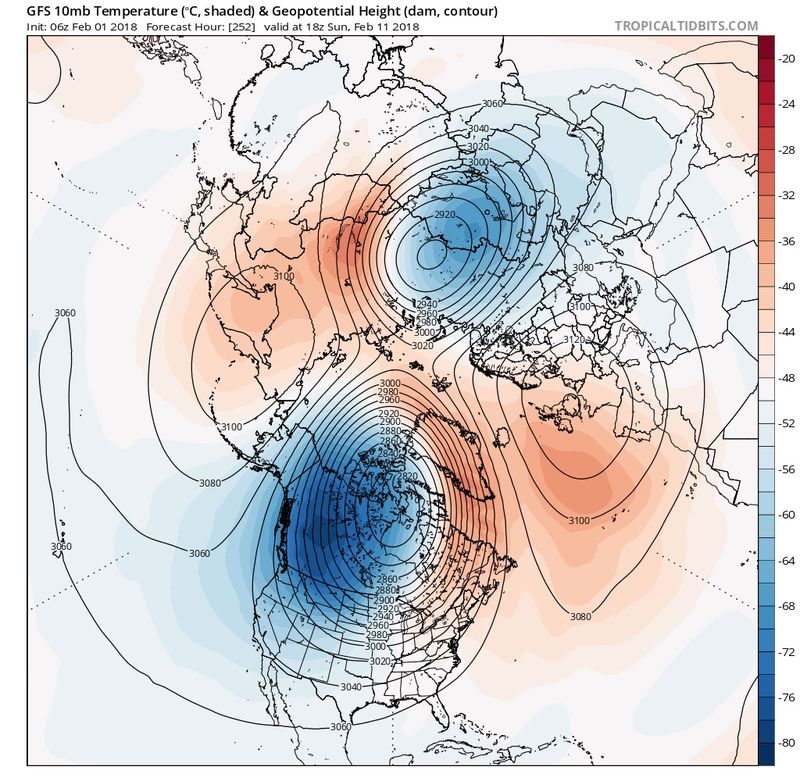

Isotherm:
Nice post John, and I don't necessarily disagree with anything written there. Just a few comments about stratospheric warming in general:
1. All stratospheric events -- displacements, splits, are highly idiosyncratic and disparate in terms of evolution.
2. Each stratospheric event will have a different impact in the troposphere, depending upon depth of split/orientation of vortices, and tropospheric-stratospheric coupling. There have been wave-2 induced split events that were poor propagators in the past.
3. Case example. January 24th, 2009 was our last w-2 induced split event, modeled fairly similarly to the evolution on the GEFS for mid month. The month following this major split event did not produce severe winter weather in the United States. Below are the February 2009 temp departures. Temperatures actually warmed after the split event, relative to January 2009's cold departures. There was no effect on the NAO modality, and the tropospheric AO only became mildly negative.
4. The follow-up wave 2 event as discussed, via tropospheric precursor and associated potent tropical forcing (through latent heat release induced rossby wave alterations and concomitant breaking, as John noted) is occurring.
The question is: a) Will wave amplitudes be as high and persistent as evinced by the GFS?, and further, B - will it propagate effectively, subsequently inducing large scale tropospheric alterations.
Given the magnitude of the MJO wave in this case, I feel fairly confident we will disturb the SPV sufficiently to attempt an official SSW event. If this occurs, it would likely be February 15th-18th based upon historical data of geopotential height preconditioning via wave 2. This is a multi-step equation though, and results are stochastic/non-linear. Even if we have a split in this period, my point is - there's no way to unequivocally state that severe winter weather will result, just yet.
_________________
"In weather and in life, there's no winning and losing; there's only winning and learning."
WINTER 2012/2013 TOTALS 43.65"WINTER 2017/2018 TOTALS 62.85" WINTER 2022/2023 TOTALS 4.9"
WINTER 2013/2014 TOTALS 64.85"WINTER 2018/2019 TOTALS 14.25" WINTER 2023/2024 TOTALS 13.1"
WINTER 2014/2015 TOTALS 71.20"WINTER 2019/2020 TOTALS 6.35"
WINTER 2015/2016 TOTALS 35.00"WINTER 2020/2021 TOTALS 37.75"
WINTER 2016/2017 TOTALS 42.25"WINTER 2021/2022 TOTALS 31.65"
sroc4- Admin
- Posts : 8331
Reputation : 301
Join date : 2013-01-07
Location : Wading River, LI
Re: Long Range Thread 16.0
![]() by Guest Fri Feb 02, 2018 9:21 am
by Guest Fri Feb 02, 2018 9:21 am
Guest- Guest
Re: Long Range Thread 16.0
![]() by sroc4 Fri Feb 02, 2018 9:28 am
by sroc4 Fri Feb 02, 2018 9:28 am
syosnow94 wrote:I see what you guys are saying, but as I said yesterday, and granted I’m not as good at this as you guys.......The PV is too far west for us. I think the short waves that rotate around have too much time to round the base and then hug the coast or cut.. We need the PV further s and e to benefit us with a favorable track. Hope I’m wrong
Jimmy you are correct in that observation and is like a direct result of the ridge axis being too far west like a mentioned above. We’ll see
_________________
"In weather and in life, there's no winning and losing; there's only winning and learning."
WINTER 2012/2013 TOTALS 43.65"WINTER 2017/2018 TOTALS 62.85" WINTER 2022/2023 TOTALS 4.9"
WINTER 2013/2014 TOTALS 64.85"WINTER 2018/2019 TOTALS 14.25" WINTER 2023/2024 TOTALS 13.1"
WINTER 2014/2015 TOTALS 71.20"WINTER 2019/2020 TOTALS 6.35"
WINTER 2015/2016 TOTALS 35.00"WINTER 2020/2021 TOTALS 37.75"
WINTER 2016/2017 TOTALS 42.25"WINTER 2021/2022 TOTALS 31.65"
sroc4- Admin
- Posts : 8331
Reputation : 301
Join date : 2013-01-07
Location : Wading River, LI
Re: Long Range Thread 16.0
![]() by amugs Fri Feb 02, 2018 9:39 am
by amugs Fri Feb 02, 2018 9:39 am
Twitter.gif.cec936be1d1b2d2b7842f61435c2a111.gif)

_________________
Mugs
AKA:King: Snow Weenie
Self Proclaimed
WINTER 2014-15 : 55.12" +.02 for 6 coatings (avg. 35")
WINTER 2015-16 Total - 29.8" (Avg 35")
WINTER 2016-17 : 39.5" so far
amugs- Advanced Forecaster - Mod
- Posts : 15093
Reputation : 213
Join date : 2013-01-07
Age : 54
Location : Hillsdale,NJ
Re: Long Range Thread 16.0
![]() by Guest Fri Feb 02, 2018 9:43 am
by Guest Fri Feb 02, 2018 9:43 am
Guest- Guest
Re: Long Range Thread 16.0
![]() by RJB8525 Fri Feb 02, 2018 10:36 am
by RJB8525 Fri Feb 02, 2018 10:36 am
syosnow94 wrote:Punxsutawney Phil is 1000% better than any of the models we watch.
Staten Island Chuck predicted early spring lmao

RJB8525- Senior Enthusiast
- Posts : 1994
Reputation : 28
Join date : 2013-02-06
Age : 38
Location : Hackettstown, NJ
Re: Long Range Thread 16.0
![]() by amugs Fri Feb 02, 2018 1:59 pm
by amugs Fri Feb 02, 2018 1:59 pm


_________________
Mugs
AKA:King: Snow Weenie
Self Proclaimed
WINTER 2014-15 : 55.12" +.02 for 6 coatings (avg. 35")
WINTER 2015-16 Total - 29.8" (Avg 35")
WINTER 2016-17 : 39.5" so far
amugs- Advanced Forecaster - Mod
- Posts : 15093
Reputation : 213
Join date : 2013-01-07
Age : 54
Location : Hillsdale,NJ
Re: Long Range Thread 16.0
![]() by amugs Fri Feb 02, 2018 2:28 pm
by amugs Fri Feb 02, 2018 2:28 pm
The PNA and EPO link very nicely on the 8th or so, sending a beautiful area of high pressure down into the CONUS, setting up a large temperature gradient for the 10th threat. This large, sprawling area of surface high pressure is not something we have for the 4-5th and 7-8th storms, so this is a good thing.
It will get quite cold in the CONUS for a few days as that HP sets in. But the Pacific Jet extension afterwards looks to be inevitable, leading to a more zonal pattern and warmth across the CONUS, while we reshuffle things in the Stratosphere. It's still not really a warm pattern in the East, though -- but it could have an "ugly" look for a couple of days.
_________________
Mugs
AKA:King: Snow Weenie
Self Proclaimed
WINTER 2014-15 : 55.12" +.02 for 6 coatings (avg. 35")
WINTER 2015-16 Total - 29.8" (Avg 35")
WINTER 2016-17 : 39.5" so far
amugs- Advanced Forecaster - Mod
- Posts : 15093
Reputation : 213
Join date : 2013-01-07
Age : 54
Location : Hillsdale,NJ
Re: Long Range Thread 16.0
![]() by frank 638 Fri Feb 02, 2018 4:51 pm
by frank 638 Fri Feb 02, 2018 4:51 pm
frank 638- Senior Enthusiast
- Posts : 2824
Reputation : 37
Join date : 2016-01-01
Age : 40
Location : bronx ny
Page 35 of 40 • 1 ... 19 ... 34, 35, 36 ... 40 ![]()
|
|
|