
 Search
February 2nd: Light Snow Event
Page 2 of 5 •  1, 2, 3, 4, 5
 ![]()
Re: February 2nd: Light Snow Event
![]() by Guest Thu Feb 01, 2018 9:19 am
by Guest Thu Feb 01, 2018 9:19 am
Big if though
Guest- Guest
Re: February 2nd: Light Snow Event
![]() by aiannone Thu Feb 01, 2018 9:27 am
by aiannone Thu Feb 01, 2018 9:27 am
syosnow94 wrote:Alex if the 12z NAM verifies verbatim we’d all be 2-4” easy.
Big if though
Yupp, i strongly dislike changeover events (wet ground, NW winds cause downsloping and erode the precip, etc), however this event has strong jet energy moving over our area which could mitigate those factors (NAM is showing this), so we will really have to nowcast. But regardless, a flash freeze will occur. Ground will not dry by the time the cold air crashes in obviously.
aiannone- Senior Enthusiast - Mod

- Posts : 4822
Join date : 2013-01-07
Re: February 2nd: Light Snow Event
![]() by sroc4 Thu Feb 01, 2018 9:47 am
by sroc4 Thu Feb 01, 2018 9:47 am
aiannone wrote:syosnow94 wrote:Alex if the 12z NAM verifies verbatim we’d all be 2-4” easy.
Big if though
Yupp, i strongly dislike changeover events (wet ground, NW winds cause downsloping and erode the precip, etc), however this event has strong jet energy moving over our area which could mitigate those factors (NAM is showing this), so we will really have to nowcast. But regardless, a flash freeze will occur. Ground will not dry by the time the cold air crashes in obviously.
12k and 3k NAM both show a nice hit
_________________
"In weather and in life, there's no winning and losing; there's only winning and learning."
WINTER 2012/2013 TOTALS 43.65"WINTER 2017/2018 TOTALS 62.85" WINTER 2022/2023 TOTALS 4.9"
WINTER 2013/2014 TOTALS 64.85"WINTER 2018/2019 TOTALS 14.25" WINTER 2023/2024 TOTALS 13.1"
WINTER 2014/2015 TOTALS 71.20"WINTER 2019/2020 TOTALS 6.35"
WINTER 2015/2016 TOTALS 35.00"WINTER 2020/2021 TOTALS 37.75"
WINTER 2016/2017 TOTALS 42.25"WINTER 2021/2022 TOTALS 31.65"

sroc4- Admin

- Posts : 8441
Reputation : 302
Join date : 2013-01-07
Location : Wading River, LI
Re: February 2nd: Light Snow Event
![]() by aiannone Thu Feb 01, 2018 9:52 am
by aiannone Thu Feb 01, 2018 9:52 am
_________________
-Alex Iannone-

aiannone- Senior Enthusiast - Mod
- Posts : 4822
Reputation : 92
Join date : 2013-01-07
Location : Saint James, LI (Northwest Suffolk Co.)
Re: February 2nd: Light Snow Event
![]() by Frank_Wx Thu Feb 01, 2018 10:13 am
by Frank_Wx Thu Feb 01, 2018 10:13 am
_________________
_______________________________________________________________________________________________________
CLICK HERE to view NJ Strong Snowstorm Classifications

Frank_Wx- Godzilla Seeker
- Posts : 21308
Reputation : 328
Join date : 2013-01-05
Age : 32
Location : Jersey City, NJ -

Re: February 2nd: Light Snow Event
![]() by sroc4 Thu Feb 01, 2018 10:17 am
by sroc4 Thu Feb 01, 2018 10:17 am
Frank_Wx wrote:It looks like a 1 to 3 inch event in my eyes. There may be pockets of towns who see 3"+ if precip rates intensify.
Concur
_________________
"In weather and in life, there's no winning and losing; there's only winning and learning."
WINTER 2012/2013 TOTALS 43.65"WINTER 2017/2018 TOTALS 62.85" WINTER 2022/2023 TOTALS 4.9"
WINTER 2013/2014 TOTALS 64.85"WINTER 2018/2019 TOTALS 14.25" WINTER 2023/2024 TOTALS 13.1"
WINTER 2014/2015 TOTALS 71.20"WINTER 2019/2020 TOTALS 6.35"
WINTER 2015/2016 TOTALS 35.00"WINTER 2020/2021 TOTALS 37.75"
WINTER 2016/2017 TOTALS 42.25"WINTER 2021/2022 TOTALS 31.65"
sroc4- Admin
- Posts : 8441
Reputation : 302
Join date : 2013-01-07
Location : Wading River, LI
Re: February 2nd: Light Snow Event
![]() by SENJsnowman Thu Feb 01, 2018 10:23 am
by SENJsnowman Thu Feb 01, 2018 10:23 am
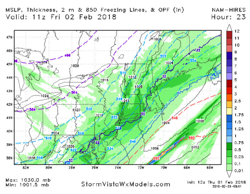
aiannone wrote:Hi-Res:
Is the 850 freezing line visible on this map and if so, could someone please point it out for me?
And more directly, is coastal NJ in as bad a shape as it looks based on the 32 line?
(Edit: OK, now that I looked at the title of the map after my post, I should rephrase the 1st question to: Can someone point it out for me please?)
(2nd Edit: Wait a minute, is the 32 the 850 freezing line? I thought that was the surface level freezing line. I'm confused...again. Ha ha. This is a rather humbling foray!)
SENJsnowman- Senior Enthusiast

- Posts : 1195
Reputation : 61
Join date : 2017-01-06
Age : 51
Location : Long Branch, NJ
Re: February 2nd: Light Snow Event
![]() by sroc4 Thu Feb 01, 2018 10:54 am
by sroc4 Thu Feb 01, 2018 10:54 am
SENJsnowman wrote:aiannone wrote:Hi-Res:
Is the 850 freezing line visible on this map and if so, could someone please point it out for me?
And more directly, is coastal NJ in as bad a shape as it looks based on the 32 line?
(Edit: OK, now that I looked at the title of the map after my post, I should rephrase the 1st question to: Can someone point it out for me please?)
(2nd Edit: Wait a minute, is the 32 the 850 freezing line? I thought that was the surface level freezing line. I'm confused...again. Ha ha. This is a rather humbling foray!)

_________________
"In weather and in life, there's no winning and losing; there's only winning and learning."
WINTER 2012/2013 TOTALS 43.65"WINTER 2017/2018 TOTALS 62.85" WINTER 2022/2023 TOTALS 4.9"
WINTER 2013/2014 TOTALS 64.85"WINTER 2018/2019 TOTALS 14.25" WINTER 2023/2024 TOTALS 13.1"
WINTER 2014/2015 TOTALS 71.20"WINTER 2019/2020 TOTALS 6.35"
WINTER 2015/2016 TOTALS 35.00"WINTER 2020/2021 TOTALS 37.75"
WINTER 2016/2017 TOTALS 42.25"WINTER 2021/2022 TOTALS 31.65"
sroc4- Admin
- Posts : 8441
Reputation : 302
Join date : 2013-01-07
Location : Wading River, LI
Re: February 2nd: Light Snow Event
![]() by SENJsnowman Thu Feb 01, 2018 11:21 am
by SENJsnowman Thu Feb 01, 2018 11:21 am
SENJsnowman- Senior Enthusiast
- Posts : 1195
Reputation : 61
Join date : 2017-01-06
Age : 51
Location : Long Branch, NJ
Re: February 2nd: Light Snow Event
![]() by rb924119 Thu Feb 01, 2018 11:23 am
by rb924119 Thu Feb 01, 2018 11:23 am
rb924119- Meteorologist

- Posts : 7033
Reputation : 195
Join date : 2013-02-06
Age : 32
Location : Greentown, Pa
Re: February 2nd: Light Snow Event
![]() by sroc4 Thu Feb 01, 2018 11:24 am
by sroc4 Thu Feb 01, 2018 11:24 am
SENJsnowman wrote:Thank you Sroc...so, I guess the cold air isn't much of a issue.
At least it wouldnt be for this model run verbatim.
_________________
"In weather and in life, there's no winning and losing; there's only winning and learning."
WINTER 2012/2013 TOTALS 43.65"WINTER 2017/2018 TOTALS 62.85" WINTER 2022/2023 TOTALS 4.9"
WINTER 2013/2014 TOTALS 64.85"WINTER 2018/2019 TOTALS 14.25" WINTER 2023/2024 TOTALS 13.1"
WINTER 2014/2015 TOTALS 71.20"WINTER 2019/2020 TOTALS 6.35"
WINTER 2015/2016 TOTALS 35.00"WINTER 2020/2021 TOTALS 37.75"
WINTER 2016/2017 TOTALS 42.25"WINTER 2021/2022 TOTALS 31.65"
sroc4- Admin
- Posts : 8441
Reputation : 302
Join date : 2013-01-07
Location : Wading River, LI
Re: February 2nd: Light Snow Event
![]() by aiannone Thu Feb 01, 2018 11:34 am
by aiannone Thu Feb 01, 2018 11:34 am
rb924119 wrote:I'm with Scott on this one, and have been. I like an enhancement of the precip field, but dissimilarly to the most recent event, I like this enhancement from east-central PA eastward, and from the approximate latitude of 295 northward. I think 1-3" would be a good call, as Frank had also stated. Intensifying mid-level energy in response to a change in the trough's axial tilt combined with a quick moving but potent jet max with the region defined above located in the overlap of forcings will allow the precip field to expand seemingly out of nowhere as, and after the low-level cold gets in.
GFS not as enthused, but I think the NAM is better at picking up on the several important factors you are pointing out here
_________________
-Alex Iannone-
aiannone- Senior Enthusiast - Mod
- Posts : 4822
Reputation : 92
Join date : 2013-01-07
Location : Saint James, LI (Northwest Suffolk Co.)
Re: February 2nd: Light Snow Event
![]() by amugs Thu Feb 01, 2018 12:03 pm
by amugs Thu Feb 01, 2018 12:03 pm
This is a anafront passage with a vigorous jets streak that will help enhance this on the backside.
1" for NW NJ to 3" out towards where else LI.
Should be a fun commute tomorrow morning.
Hi Res Models way to go here.
_________________
Mugs
AKA:King: Snow Weenie
Self Proclaimed
WINTER 2014-15 : 55.12" +.02 for 6 coatings (avg. 35")
WINTER 2015-16 Total - 29.8" (Avg 35")
WINTER 2016-17 : 39.5" so far

amugs- Advanced Forecaster - Mod
- Posts : 15130
Reputation : 213
Join date : 2013-01-07
Age : 54
Location : Hillsdale,NJ
Re: February 2nd: Light Snow Event
![]() by Dunnzoo Thu Feb 01, 2018 12:12 pm
by Dunnzoo Thu Feb 01, 2018 12:12 pm
amugs wrote:Scott, Rb great points made here.
This is a anafront passage with a vigorous jets streak that will help enhance this on the backside.
1" for NW NJ to 3" out towards where else LI.
Should be a fun commute tomorrow morning.
Hi Res Models way to go here.
I'm worried about the a.m. too, rain going into a deep freeze will bring icing on the roads with the snow, not going to be fun for sure.
_________________
Janet
Snowfall winter of 2023-2024 17.5"
Snowfall winter of 2022-2023 6.0"
Snowfall winter of 2021-2022 17.6" 1" sleet 2/25/22
Snowfall winter of 2020-2021 51.1"
Snowfall winter of 2019-2020 8.5"
Snowfall winter of 2018-2019 25.1"
Snowfall winter of 2017-2018 51.9"
Snowfall winter of 2016-2017 45.6"
Snowfall winter of 2015-2016 29.5"
Snowfall winter of 2014-2015 50.55"
Snowfall winter of 2013-2014 66.5"

Dunnzoo- Senior Enthusiast - Mod
- Posts : 4920
Reputation : 68
Join date : 2013-01-11
Age : 62
Location : Westwood, NJ
Re: February 2nd: Light Snow Event
![]() by amugs Thu Feb 01, 2018 2:04 pm
by amugs Thu Feb 01, 2018 2:04 pm
Cold Press at work


_________________
Mugs
AKA:King: Snow Weenie
Self Proclaimed
WINTER 2014-15 : 55.12" +.02 for 6 coatings (avg. 35")
WINTER 2015-16 Total - 29.8" (Avg 35")
WINTER 2016-17 : 39.5" so far
amugs- Advanced Forecaster - Mod
- Posts : 15130
Reputation : 213
Join date : 2013-01-07
Age : 54
Location : Hillsdale,NJ
Re: February 2nd: Light Snow Event
![]() by amugs Thu Feb 01, 2018 2:21 pm
by amugs Thu Feb 01, 2018 2:21 pm
Mike (Math23x7) did you see those maps?
_________________
Mugs
AKA:King: Snow Weenie
Self Proclaimed
WINTER 2014-15 : 55.12" +.02 for 6 coatings (avg. 35")
WINTER 2015-16 Total - 29.8" (Avg 35")
WINTER 2016-17 : 39.5" so far
amugs- Advanced Forecaster - Mod
- Posts : 15130
Reputation : 213
Join date : 2013-01-07
Age : 54
Location : Hillsdale,NJ
Re: February 2nd: Light Snow Event
![]() by aiannone Thu Feb 01, 2018 2:27 pm
by aiannone Thu Feb 01, 2018 2:27 pm
_________________
-Alex Iannone-
aiannone- Senior Enthusiast - Mod
- Posts : 4822
Reputation : 92
Join date : 2013-01-07
Location : Saint James, LI (Northwest Suffolk Co.)
Re: February 2nd: Light Snow Event
![]() by GreyBeard Thu Feb 01, 2018 2:40 pm
by GreyBeard Thu Feb 01, 2018 2:40 pm
.NEAR TERM /THROUGH TONIGHT/...
Updated temperatures/dewpoints and winds with this afternoon
update to reflect current conditions.
Otherwise, broad longwave trough over the lower 48 will sharpen
over the next 24 hours as a mid level shortwave over the
central Plains strengthens and moves towards the Mid Atlantic
states. At the sfc, a cold front will approach from the west.
The combination of frontal forcing, the exit region of a
150-160kt upper jet and mid level frontogenesis will contribute
to the blossoming of pcpn early this evening and continuing
overnight.
The first half of the day will be cloudy but should be dry with
the local area warm sectored. May start to see pcpn in the form
of rain move into areas well NW of NYC this afternoon, but the
better chances will hold off until the front and better upper
dynamics move closer to the region. Pcpn ahead of the front will
be in liquid form but it also lags behind as the exit region of
the upper level jet moves over the area late tonight. Most
model guidance indicate QPF between 1/10 and 1/3 of an inch,
highest amounts east, except for the SREF mean which is around
1/4 of an inch higher. This is interesting because the upper jet
is weaker as is the mid level frontogenesis. So stronger
dynamics don`t appear to be the reason for the higher values.
It`s progression is a bit slower which could be the contributing
factor.
The tricky part of the forecast is how quickly the column cools
for the rain to change over to snow and the subsequent
accumulation amounts. GFS soundings look more reasonable given
the scenario with changeover occurring around 07z in NW zones,
09z in the NYC metro area and 10-11z in southern CT and Long
Island. Since the changeover is anticipated to be late, only
expect light snow accumulations, generally less than an inch at
most locations, although can`t rule out a few 1-2" accumulations
especially across SE CT and eastern LI.
&&
.SHORT TERM /FRIDAY/...
Any lingering pcpn will end during Fri morning with
strengthening NW winds from strong CAA. Winds of 15-25mph with
30-35mph gusts will be common during the day. Highs will only be
a few degrees higher than tonights lows, generally mid to upper
20s, possibly lower 30s in the NYC metro area.
&&
.LONG TERM /FRIDAY NIGHT THROUGH WEDNESDAY/...
Zonal flow aloft Friday night and Saturday, with no significant
shortwaves embedded in the flow, should allow for dry conditions
both periods. Temperatures will be very cold for this time of year.
Lows Friday night should generally be from around 5 to 15 above,
with wind chills from 5 below to around 5 above (around 0 to 5 above
in NYC). Highs on Saturday should be around 10 degrees below normal:
mainly from the mid 20s to around 30.
SW flow sets up aloft Saturday night, with low level warm advection
bringing some spotty light snow to mainly the NW 1/2 of the CWA late
Saturday night. A 700-500 hPa shortwave coupled with increasing
isentropic ascent will produce more widespread precipitation on
Sunday, especially in the afternoon. A 700-500 hPa trough then
approaches Sunday night then lifts to the NE on Monday. This will
help drive the intensification of a coastal low of the Mid Atlantic
Coast Sunday night. This coastal low tracks SE of Long Island, but
probably inside the 40N/70W benchmark Sunday night, before lifting
NE on Monday. There is some uncertainty on this timing, with some
suggestion that things might occur 6 hours or so faster than
current forecast.
In terms of sensible weather Sunday-Monday morning. Will see
precipitation change from snow to a wintry mix across the interior
and from snow to rain elsewhere. There are then differences in how
quickly low level cold air returns Sunday night. For now keep
transitions back to all snow across mainly far northern portions of
interior zones Sunday night, with a wintry mix possible across the
remainder of the northern/far western zones - with NYC/Long
Island/Coastal SE CT staying all rain. Precipitation ends on Monday
morning, as snow across interior zones/coastal SW CT zones. A wintry
mix over E NE NJ/into NYC and as plain rain over Long Island/coastal
SE CT. For now to early to specify amounts, but there is some
potential for an advisory level to possibly a warning level snowfall
across mainly northern interior zones from Sunday into Monday
morning. Will address this potential in the HWO.
Zonal flow with no shortwaves of note should allow for Monday night
to be dry.
Low level warm advection sets up on Tuesday. For now appears that
most precipitation should be limited to the N/NW of the region,
except for maybe some light snow over far W Orange County.
Continuing low level warm advection and the passing of a strong low
level jet (40-50 KT) should bring some snow to most of the area
Tuesday night, with potential for some rain to mix in across
NYC/southern Long Island. An approaching 700-500 hPa trough
Wednesday should sharpen low level flow more towards the S-SW - so
low level warm advection should be sufficient to turn all
precipitation to rain. For now there is too much uncertainty to
gage how much, if any snow ends up accumulating Tuesday night and
Wednesday.
GreyBeard- Senior Enthusiast
- Posts : 731
Reputation : 34
Join date : 2014-02-12
Location : Boca Raton, Fl.
Re: February 2nd: Light Snow Event
![]() by Guest Thu Feb 01, 2018 2:59 pm
by Guest Thu Feb 01, 2018 2:59 pm
Guest- Guest
Re: February 2nd: Light Snow Event
![]() by rb924119 Thu Feb 01, 2018 3:01 pm
by rb924119 Thu Feb 01, 2018 3:01 pm
rb924119- Meteorologist
- Posts : 7033
Reputation : 195
Join date : 2013-02-06
Age : 32
Location : Greentown, Pa
Re: February 2nd: Light Snow Event
![]() by rb924119 Thu Feb 01, 2018 3:01 pm
by rb924119 Thu Feb 01, 2018 3:01 pm
rb924119- Meteorologist
- Posts : 7033
Reputation : 195
Join date : 2013-02-06
Age : 32
Location : Greentown, Pa
Re: February 2nd: Light Snow Event
![]() by aiannone Thu Feb 01, 2018 3:05 pm
by aiannone Thu Feb 01, 2018 3:05 pm
rb924119 wrote:Welp the 18z NAM just gave the finger to the NWS and strongly supports our collective thinking that a nearly board-wide 1-3" event is in store for tonight. Happy thoughts, Syo, happy thoughts!!
And since they are model huggers, they might actually adjust the forecast
_________________
-Alex Iannone-
aiannone- Senior Enthusiast - Mod
- Posts : 4822
Reputation : 92
Join date : 2013-01-07
Location : Saint James, LI (Northwest Suffolk Co.)
Re: February 2nd: Light Snow Event
![]() by GreyBeard Thu Feb 01, 2018 3:07 pm
by GreyBeard Thu Feb 01, 2018 3:07 pm
syosnow94 wrote:GreyBeard if this forecast verifies it will be like a series of hard punches to the gut. Give me 60 on Christmas instead of this for gods sake
I agree sysos, however as many have stated, the NWS tends to lean more to the conservative side, which is hopefully what will happen. I was hoping for a repeat of the cold we had back in early Jan.Something the main guys on the forum are still bullish about. Time will tell I guess.
GreyBeard- Senior Enthusiast
- Posts : 731
Reputation : 34
Join date : 2014-02-12
Location : Boca Raton, Fl.
Re: February 2nd: Light Snow Event
![]() by GreyBeard Thu Feb 01, 2018 3:09 pm
by GreyBeard Thu Feb 01, 2018 3:09 pm
GreyBeard wrote:syosnow94 wrote:GreyBeard if this forecast verifies it will be like a series of hard punches to the gut. Give me 60 on Christmas instead of this for gods sake
I agree sysos, however as many have stated, the NWS tends to lean more to the conservative side, which is hopefully what will happen. I was hoping for a repeat of the cold we had back in early Jan.Something the main guys on the forum are still bullish about. Time will tell I guess.
Rb and aianonne filled in the blanks while I was responding to you lol.
GreyBeard- Senior Enthusiast
- Posts : 731
Reputation : 34
Join date : 2014-02-12
Location : Boca Raton, Fl.
Re: February 2nd: Light Snow Event
![]() by amugs Thu Feb 01, 2018 3:44 pm
by amugs Thu Feb 01, 2018 3:44 pm
_________________
Mugs
AKA:King: Snow Weenie
Self Proclaimed
WINTER 2014-15 : 55.12" +.02 for 6 coatings (avg. 35")
WINTER 2015-16 Total - 29.8" (Avg 35")
WINTER 2016-17 : 39.5" so far
amugs- Advanced Forecaster - Mod
- Posts : 15130
Reputation : 213
Join date : 2013-01-07
Age : 54
Location : Hillsdale,NJ
Re: February 2nd: Light Snow Event
![]() by aiannone Thu Feb 01, 2018 3:57 pm
by aiannone Thu Feb 01, 2018 3:57 pm
_________________
-Alex Iannone-
aiannone- Senior Enthusiast - Mod
- Posts : 4822
Reputation : 92
Join date : 2013-01-07
Location : Saint James, LI (Northwest Suffolk Co.)
Re: February 2nd: Light Snow Event
![]() by aiannone Thu Feb 01, 2018 4:00 pm
by aiannone Thu Feb 01, 2018 4:00 pm
As the front pushes eastward overnight, temperatures will drop
rapidly resulting in the rain becoming a wintry mix across the
entire area before changing to all snow. The changeover is expected
to occur around 1 to 3 am across areas northwest of the NYC metro
area, around 3 to 4 am across NYC metro area and 4 to 5 am across
Connecticut and Long Island. Snowfall accumulations should be
between 1 to 2 inches but, can`t rule out some locations seeing up
to 3 inches if any heavier snow bands develop or if the rain change
over to snow is an hour earlier than expected.
_________________
-Alex Iannone-
aiannone- Senior Enthusiast - Mod
- Posts : 4822
Reputation : 92
Join date : 2013-01-07
Location : Saint James, LI (Northwest Suffolk Co.)
Page 2 of 5 • 1, 2, 3, 4, 5 ![]()
|
|
|