
 Search
February 2nd: Light Snow Event
Page 3 of 5 •  1, 2, 3, 4, 5
 ![]()
Re: February 2nd: Light Snow Event
![]() by aiannone Thu Feb 01, 2018 3:57 pm
by aiannone Thu Feb 01, 2018 3:57 pm
aiannone- Senior Enthusiast - Mod

- Posts : 4815
Join date : 2013-01-07
Re: February 2nd: Light Snow Event
![]() by aiannone Thu Feb 01, 2018 4:00 pm
by aiannone Thu Feb 01, 2018 4:00 pm
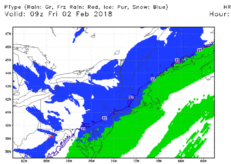
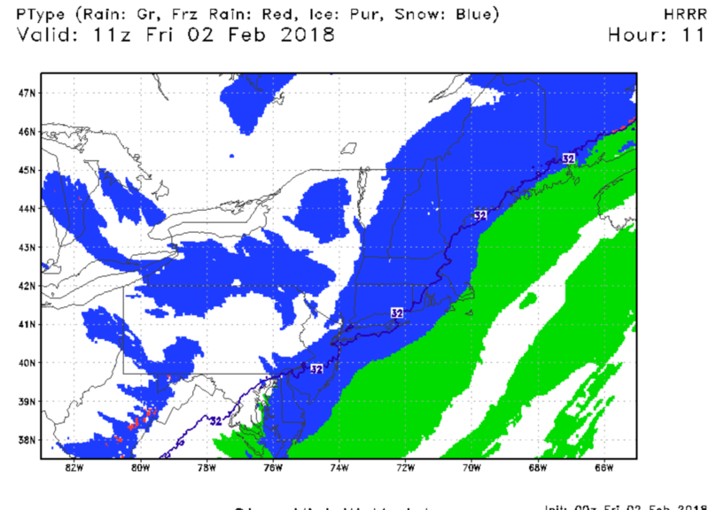
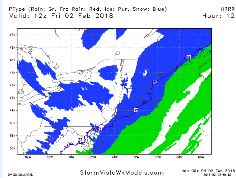
As the front pushes eastward overnight, temperatures will drop
rapidly resulting in the rain becoming a wintry mix across the
entire area before changing to all snow. The changeover is expected
to occur around 1 to 3 am across areas northwest of the NYC metro
area, around 3 to 4 am across NYC metro area and 4 to 5 am across
Connecticut and Long Island. Snowfall accumulations should be
between 1 to 2 inches but, can`t rule out some locations seeing up
to 3 inches if any heavier snow bands develop or if the rain change
over to snow is an hour earlier than expected.
aiannone- Senior Enthusiast - Mod
- Posts : 4815
Join date : 2013-01-07
Re: February 2nd: Light Snow Event
![]() by Taffy Thu Feb 01, 2018 4:07 pm
by Taffy Thu Feb 01, 2018 4:07 pm
Until 5:00am EST, Fri Feb 2
Action Recommended: Avoid the subject event as per the instructions
Issued by: New York City - NY, US, National Weather Service,
...HAZARDOUS FRIDAY MORNING COMMUTE EXPECTED... A COLD FRONT IS FORECAST TO MOVE ACROSS THE AREA TONIGHT AND INTO EARLY FRIDAY MORNING. PRECIPITATION WITH THE FRONT IS EXPECTED TO START AS RAIN, HOWEVER AS COLDER AIR MOVES IN BEHIND THE FRONT, THE RAIN WILL CHANGE OVER TO A WINTRY MIX BEFORE CHANGING TO ALL SNOW AFTER MIDNIGHT. AS TEMPERATURES FALL TOWARDS AND BELOW FREEZING BY FRIDAY MORNING, THERE IS A HIGH THREAT FOR ICY CONDITIONS TO DEVELOP DURING THE MORNING COMMUTE, RESULTING IN HAZARDOUS DRIVING CONDITIONS.

Taffy- Pro Enthusiast

- Posts : 530
Reputation : 19
Join date : 2013-10-06
Location : Hopkinton, MA
Re: February 2nd: Light Snow Event
![]() by amugs Thu Feb 01, 2018 6:26 pm
by amugs Thu Feb 01, 2018 6:26 pm

_________________
Mugs
AKA:King: Snow Weenie
Self Proclaimed
WINTER 2014-15 : 55.12" +.02 for 6 coatings (avg. 35")
WINTER 2015-16 Total - 29.8" (Avg 35")
WINTER 2016-17 : 39.5" so far

amugs- Advanced Forecaster - Mod
- Posts : 15095
Reputation : 213
Join date : 2013-01-07
Age : 54
Location : Hillsdale,NJ
Re: February 2nd: Light Snow Event
![]() by bobjohnsonforthehall Thu Feb 01, 2018 6:33 pm
by bobjohnsonforthehall Thu Feb 01, 2018 6:33 pm

bobjohnsonforthehall- Posts : 311
Reputation : 19
Join date : 2016-10-02
Location : Flemington NJ

Vinnydula- Pro Enthusiast
- Posts : 778
Reputation : 8
Join date : 2013-12-12
Location : Dobbs ferry
Re: February 2nd: Light Snow Event
![]() by aiannone Thu Feb 01, 2018 8:16 pm
by aiannone Thu Feb 01, 2018 8:16 pm

_________________
-Alex Iannone-

aiannone- Senior Enthusiast - Mod
- Posts : 4815
Reputation : 92
Join date : 2013-01-07
Location : Saint James, LI (Northwest Suffolk Co.)
Re: February 2nd: Light Snow Event
![]() by amugs Thu Feb 01, 2018 8:20 pm
by amugs Thu Feb 01, 2018 8:20 pm
_________________
Mugs
AKA:King: Snow Weenie
Self Proclaimed
WINTER 2014-15 : 55.12" +.02 for 6 coatings (avg. 35")
WINTER 2015-16 Total - 29.8" (Avg 35")
WINTER 2016-17 : 39.5" so far
amugs- Advanced Forecaster - Mod
- Posts : 15095
Reputation : 213
Join date : 2013-01-07
Age : 54
Location : Hillsdale,NJ
Re: February 2nd: Light Snow Event
![]() by aiannone Thu Feb 01, 2018 8:24 pm
by aiannone Thu Feb 01, 2018 8:24 pm
amugs wrote:Delayed Opening's for schools are looking pretty good if these SR models verify.
For sure. School maintenance will have to salt, possibly scrape parking lots and let DOT treat the roads
_________________
-Alex Iannone-
aiannone- Senior Enthusiast - Mod
- Posts : 4815
Reputation : 92
Join date : 2013-01-07
Location : Saint James, LI (Northwest Suffolk Co.)
Re: February 2nd: Light Snow Event
![]() by billg315 Thu Feb 01, 2018 8:27 pm
by billg315 Thu Feb 01, 2018 8:27 pm

billg315- Advanced Forecaster - Mod
- Posts : 4483
Reputation : 185
Join date : 2015-01-24
Age : 50
Location : Flemington, NJ
Re: February 2nd: Light Snow Event
![]() by aiannone Thu Feb 01, 2018 8:29 pm
by aiannone Thu Feb 01, 2018 8:29 pm
billg315 wrote:37* here. I’m thinking the change to snow will be quick here (before 1 am) because it has gotten a little colder a little quicker than I expected.
Agreed. Never got to 45 today as forecasted. Also still have my snow cover
_________________
-Alex Iannone-
aiannone- Senior Enthusiast - Mod
- Posts : 4815
Reputation : 92
Join date : 2013-01-07
Location : Saint James, LI (Northwest Suffolk Co.)
Re: February 2nd: Light Snow Event
![]() by aiannone Thu Feb 01, 2018 8:38 pm
by aiannone Thu Feb 01, 2018 8:38 pm
_________________
-Alex Iannone-
aiannone- Senior Enthusiast - Mod
- Posts : 4815
Reputation : 92
Join date : 2013-01-07
Location : Saint James, LI (Northwest Suffolk Co.)
Re: February 2nd: Light Snow Event
![]() by billg315 Thu Feb 01, 2018 8:42 pm
by billg315 Thu Feb 01, 2018 8:42 pm
aiannone wrote:billg315 wrote:37* here. I’m thinking the change to snow will be quick here (before 1 am) because it has gotten a little colder a little quicker than I expected.
Agreed. Never got to 45 today as forecasted. Also still have my snow cover
Haha, I know all about your snow cover. You’re hoarding it out there on the Island.
billg315- Advanced Forecaster - Mod
- Posts : 4483
Reputation : 185
Join date : 2015-01-24
Age : 50
Location : Flemington, NJ
Re: February 2nd: Light Snow Event
![]() by aiannone Thu Feb 01, 2018 8:44 pm
by aiannone Thu Feb 01, 2018 8:44 pm
billg315 wrote:aiannone wrote:billg315 wrote:37* here. I’m thinking the change to snow will be quick here (before 1 am) because it has gotten a little colder a little quicker than I expected.
Agreed. Never got to 45 today as forecasted. Also still have my snow cover
Haha, I know all about your snow cover. You’re hoarding it out there on the Island.
Islip is tied with BGM for snowfall so far this season lol
_________________
-Alex Iannone-
aiannone- Senior Enthusiast - Mod
- Posts : 4815
Reputation : 92
Join date : 2013-01-07
Location : Saint James, LI (Northwest Suffolk Co.)
Re: February 2nd: Light Snow Event
![]() by billg315 Thu Feb 01, 2018 8:46 pm
by billg315 Thu Feb 01, 2018 8:46 pm
billg315- Advanced Forecaster - Mod
- Posts : 4483
Reputation : 185
Join date : 2015-01-24
Age : 50
Location : Flemington, NJ
Re: February 2nd: Light Snow Event
![]() by aiannone Thu Feb 01, 2018 8:49 pm
by aiannone Thu Feb 01, 2018 8:49 pm
billg315 wrote:Radar looks robust to the west and southwest. Looks like it’s already snow in a lot of eastern PA. I’m thinking I might get a nice surprise from this. We shall see.
Yupp certainly a healthy looking radar
_________________
-Alex Iannone-
aiannone- Senior Enthusiast - Mod
- Posts : 4815
Reputation : 92
Join date : 2013-01-07
Location : Saint James, LI (Northwest Suffolk Co.)
Re: February 2nd: Light Snow Event
![]() by aiannone Thu Feb 01, 2018 8:57 pm
by aiannone Thu Feb 01, 2018 8:57 pm
_________________
-Alex Iannone-
aiannone- Senior Enthusiast - Mod
- Posts : 4815
Reputation : 92
Join date : 2013-01-07
Location : Saint James, LI (Northwest Suffolk Co.)
Re: February 2nd: Light Snow Event
![]() by billg315 Thu Feb 01, 2018 9:01 pm
by billg315 Thu Feb 01, 2018 9:01 pm
billg315- Advanced Forecaster - Mod
- Posts : 4483
Reputation : 185
Join date : 2015-01-24
Age : 50
Location : Flemington, NJ
Re: February 2nd: Light Snow Event
![]() by aiannone Thu Feb 01, 2018 9:03 pm
by aiannone Thu Feb 01, 2018 9:03 pm
billg315 wrote:Going on a limb here. I feel the snow will be a little heavier and last a little longer than expected. If I woke up to 2 or 3” tomorrow I wouldn’t be shocked.
Agreed and areas to the west are already changing over much quicker than expected
_________________
-Alex Iannone-
aiannone- Senior Enthusiast - Mod
- Posts : 4815
Reputation : 92
Join date : 2013-01-07
Location : Saint James, LI (Northwest Suffolk Co.)
Re: February 2nd: Light Snow Event
![]() by billg315 Thu Feb 01, 2018 9:06 pm
by billg315 Thu Feb 01, 2018 9:06 pm
billg315- Advanced Forecaster - Mod
- Posts : 4483
Reputation : 185
Join date : 2015-01-24
Age : 50
Location : Flemington, NJ
billg315- Advanced Forecaster - Mod
- Posts : 4483
Reputation : 185
Join date : 2015-01-24
Age : 50
Location : Flemington, NJ
Re: February 2nd: Light Snow Event
![]() by jimv45 Thu Feb 01, 2018 9:08 pm
by jimv45 Thu Feb 01, 2018 9:08 pm
jimv45- Senior Enthusiast

- Posts : 1168
Reputation : 36
Join date : 2013-09-20
Location : Hopewell jct.
Re: February 2nd: Light Snow Event
![]() by aiannone Thu Feb 01, 2018 9:09 pm
by aiannone Thu Feb 01, 2018 9:09 pm
_________________
-Alex Iannone-
aiannone- Senior Enthusiast - Mod
- Posts : 4815
Reputation : 92
Join date : 2013-01-07
Location : Saint James, LI (Northwest Suffolk Co.)
Re: February 2nd: Light Snow Event
![]() by billg315 Thu Feb 01, 2018 9:11 pm
by billg315 Thu Feb 01, 2018 9:11 pm
billg315- Advanced Forecaster - Mod
- Posts : 4483
Reputation : 185
Join date : 2015-01-24
Age : 50
Location : Flemington, NJ
Re: February 2nd: Light Snow Event
![]() by billg315 Thu Feb 01, 2018 9:18 pm
by billg315 Thu Feb 01, 2018 9:18 pm
billg315- Advanced Forecaster - Mod
- Posts : 4483
Reputation : 185
Join date : 2015-01-24
Age : 50
Location : Flemington, NJ
Re: February 2nd: Light Snow Event
![]() by amugs Thu Feb 01, 2018 9:18 pm
by amugs Thu Feb 01, 2018 9:18 pm
billg315 wrote:37* here. I’m thinking the change to snow will be quick here (before 1 am) because it has gotten a little colder a little quicker than I expected.
Check out the R/S line trucking east so true my man - going to be nice surprise come sunrise!!!

_________________
Mugs
AKA:King: Snow Weenie
Self Proclaimed
WINTER 2014-15 : 55.12" +.02 for 6 coatings (avg. 35")
WINTER 2015-16 Total - 29.8" (Avg 35")
WINTER 2016-17 : 39.5" so far
amugs- Advanced Forecaster - Mod
- Posts : 15095
Reputation : 213
Join date : 2013-01-07
Age : 54
Location : Hillsdale,NJ
Re: February 2nd: Light Snow Event
![]() by aiannone Thu Feb 01, 2018 9:19 pm
by aiannone Thu Feb 01, 2018 9:19 pm
billg315 wrote:Agreed on a WWA. I’ve felt even without snow, the ice would be an issue for the AM rush. I think snow on top of that could make things even more treacherous.
Taunton expanded their WWA for that reason:
7 PM Update...
Main change to forecast this time around is to expand the Winter
Weather Advisory farther east...into NW Rhode Island, Red Sox Suck
MetroWest and MetroNorth. Temperatures cooling below freezing as
a band of heavier snow moves through has at least a 50 percent
chance of generating hazardous weather. This headline is
intended due to impact on the area late tonight and Friday
morning and not for achieving numerical goals such as snow
accumulation.
_________________
-Alex Iannone-
aiannone- Senior Enthusiast - Mod
- Posts : 4815
Reputation : 92
Join date : 2013-01-07
Location : Saint James, LI (Northwest Suffolk Co.)
Page 3 of 5 • 1, 2, 3, 4, 5 ![]()
|
|
|