
 Search
FEB 17th-18th Snow? Sleet? Rain?
Page 2 of 15 •  1, 2, 3 ... 8 ... 15
 ![]()
Re: FEB 17th-18th Snow? Sleet? Rain?
![]() by sroc4 Thu Feb 15, 2018 10:26 am
by sroc4 Thu Feb 15, 2018 10:26 am
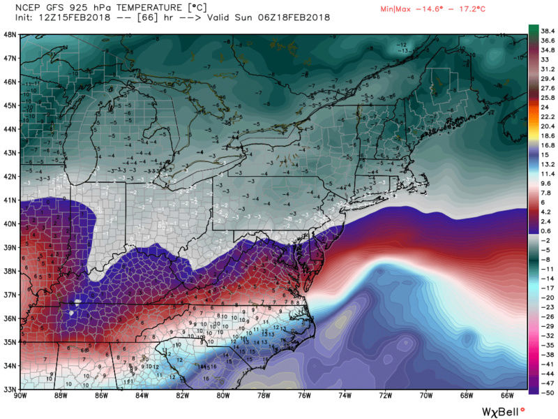
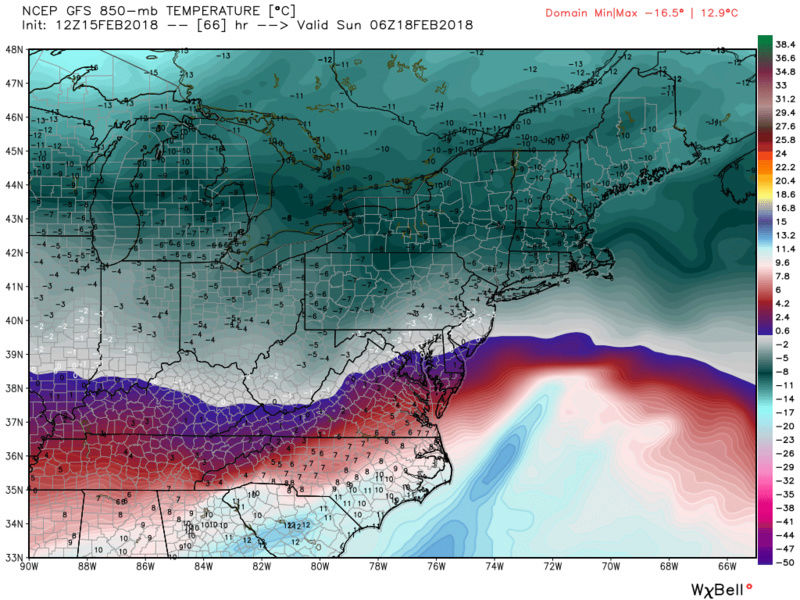
Frank_Wx wrote:It is going to be a close call where the rain/snow line sets up. A weaker system means colder temps and snow for most people. A stronger / northerly track system will bring rain to the coast while bringing heavy snow to the N&W. I do not like that the cold air mass on Saturday appears stale, and that there is a High Pressure exiting off the coast Saturday afternoon into evening. At this time I would expect more wet than white along the coast and a moderate snow event for those N&W.
I may put out a snow map later today
Frank I would argue that a stronger system but a track say off the delmarva would actually enhance snow totals along the coast. A stronger system does not necessarily mean the track will be too far north. With an exiting HP the weaker system would more likely lead to a more easterly/southeasterly wind component for longer vs a tighter system would quickly lead to the E to NE component keeping mid levels colder. With a decent jet streak placement and intensity and the H5 modeling of the subtle phasing and stronger N s/w a stronger system is where Im leaning right now.
sroc4- Admin

- Posts : 8354
Join date : 2013-01-07
Re: FEB 17th-18th Snow? Sleet? Rain?
![]() by algae888 Thu Feb 15, 2018 10:27 am
by algae888 Thu Feb 15, 2018 10:27 am
I tend to disagree every model has all layers below freezing except the surface which is hovering just above freezing. The air mass will be very dry the heavier the precipitation the more Dynamic cooling will have. You can add in a Southeast Breeze off water temperatures in the upper 30s at less than 10 miles per hour will have minimal effect. In most cases the position of the high is unfavorable but not this time and at this time of year just my opinionFrank_Wx wrote:It is going to be a close call where the rain/snow line sets up. A weaker system means colder temps and snow for most people. A stronger / northerly track system will bring rain to the coast while bringing heavy snow to the N&W. I do not like that the cold air mass on Saturday appears stale, and that there is a High Pressure exiting off the coast Saturday afternoon into evening. At this time I would expect more wet than white along the coast and a moderate snow event for those N&W.
I may put out a snow map later today
algae888- Advanced Forecaster

- Posts : 5311
Join date : 2013-02-05
Re: FEB 17th-18th Snow? Sleet? Rain?
![]() by algae888 Thu Feb 15, 2018 10:30 am
by algae888 Thu Feb 15, 2018 10:30 am

algae888- Advanced Forecaster
- Posts : 5311
Reputation : 46
Join date : 2013-02-05
Age : 62
Location : mt. vernon, new york
Re: FEB 17th-18th Snow? Sleet? Rain?
![]() by sroc4 Thu Feb 15, 2018 11:39 am
by sroc4 Thu Feb 15, 2018 11:39 am
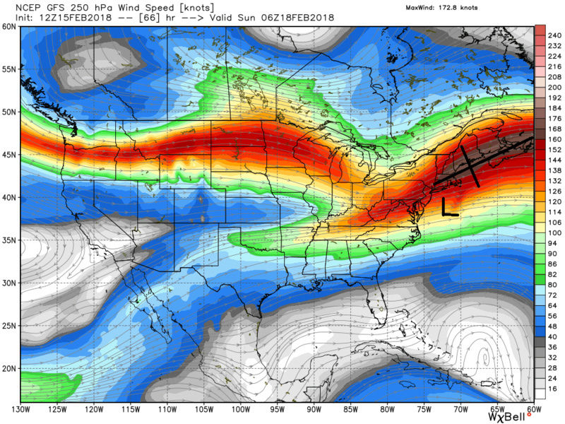
On pretty much all modeling there is a decent upper level jet streak (JS) in good position to the N NE of us which enhances the upper level divergence such that the R rear quadrant of the JS experiences enhanced vertical motion which should lower pressures more so than what is shown on the GFS surface map. GFS is too weak with the LP given the mid and upper levels IMO.
If the upper and mid levels are accurate this would a) tighten up the pressure gradient on this map which would allow for a more NE wind component vs easterly. This would keep the mid levels colder. And b) expand the precip shield NW. Verbatim. As it is with the weak LP the lower levels are remaining below freezing. Yesterday the GFS was warm
_________________
"In weather and in life, there's no winning and losing; there's only winning and learning."
WINTER 2012/2013 TOTALS 43.65"WINTER 2017/2018 TOTALS 62.85" WINTER 2022/2023 TOTALS 4.9"
WINTER 2013/2014 TOTALS 64.85"WINTER 2018/2019 TOTALS 14.25" WINTER 2023/2024 TOTALS 13.1"
WINTER 2014/2015 TOTALS 71.20"WINTER 2019/2020 TOTALS 6.35"
WINTER 2015/2016 TOTALS 35.00"WINTER 2020/2021 TOTALS 37.75"
WINTER 2016/2017 TOTALS 42.25"WINTER 2021/2022 TOTALS 31.65"

sroc4- Admin
- Posts : 8354
Reputation : 302
Join date : 2013-01-07
Location : Wading River, LI
Re: FEB 17th-18th Snow? Sleet? Rain?
![]() by Guest Thu Feb 15, 2018 1:10 pm
by Guest Thu Feb 15, 2018 1:10 pm
Guest- Guest
Re: FEB 17th-18th Snow? Sleet? Rain?
![]() by sroc4 Thu Feb 15, 2018 2:29 pm
by sroc4 Thu Feb 15, 2018 2:29 pm
_________________
"In weather and in life, there's no winning and losing; there's only winning and learning."
WINTER 2012/2013 TOTALS 43.65"WINTER 2017/2018 TOTALS 62.85" WINTER 2022/2023 TOTALS 4.9"
WINTER 2013/2014 TOTALS 64.85"WINTER 2018/2019 TOTALS 14.25" WINTER 2023/2024 TOTALS 13.1"
WINTER 2014/2015 TOTALS 71.20"WINTER 2019/2020 TOTALS 6.35"
WINTER 2015/2016 TOTALS 35.00"WINTER 2020/2021 TOTALS 37.75"
WINTER 2016/2017 TOTALS 42.25"WINTER 2021/2022 TOTALS 31.65"
sroc4- Admin
- Posts : 8354
Reputation : 302
Join date : 2013-01-07
Location : Wading River, LI
Re: FEB 17th-18th Snow? Sleet? Rain?
![]() by aiannone Thu Feb 15, 2018 2:35 pm
by aiannone Thu Feb 15, 2018 2:35 pm
sroc4 wrote:There is a good chance north of the LIE vs south of the LIE will vary greatly here with thsis system if you live on LI
Very possible. However those storms very rarely work out. it's either rain island wide or not. However, during nemo it was snowing 3-4" per hour at my house while the south shore and twin forks were raining. I've seen many more events where the forks rain while everyone snows, but the LIE division is pretty rare. We will see
_________________
-Alex Iannone-

aiannone- Senior Enthusiast - Mod

- Posts : 4815
Reputation : 92
Join date : 2013-01-07
Location : Saint James, LI (Northwest Suffolk Co.)
Re: FEB 17th-18th Snow? Sleet? Rain?
![]() by Math23x7 Thu Feb 15, 2018 2:39 pm
by Math23x7 Thu Feb 15, 2018 2:39 pm
sroc4 wrote:There is a good chance north of the LIE vs south of the LIE will vary greatly here with thsis system if you live on LI
More specifically, the cutoff would be the hill across Brooklyn/Queens/Nassau/Suffolk. I have mentioned this before on this forum. James is very familiar with this, especially with the hill on Commonwealth Blvd in Glen Oaks north of Union Turnpike. Also, James knows about this hill as Great Neck South is not far from Community Drive. North of the L.I.E there is a sharp downhill going into Manhasset. At the bottom is a hospital.
At any rate, I could see the rain/snow line aligning with this hill over the weekend. Since I am now north of that hill here in Manhattan, I should be snowing longer than in Bellerose
Math23x7- Wx Statistician Guru

- Posts : 2379
Reputation : 68
Join date : 2013-01-08
Re: FEB 17th-18th Snow? Sleet? Rain?
![]() by aiannone Thu Feb 15, 2018 3:26 pm
by aiannone Thu Feb 15, 2018 3:26 pm
_________________
-Alex Iannone-
aiannone- Senior Enthusiast - Mod
- Posts : 4815
Reputation : 92
Join date : 2013-01-07
Location : Saint James, LI (Northwest Suffolk Co.)
Re: FEB 17th-18th Snow? Sleet? Rain?
![]() by aiannone Thu Feb 15, 2018 3:40 pm
by aiannone Thu Feb 15, 2018 3:40 pm
_________________
-Alex Iannone-
aiannone- Senior Enthusiast - Mod
- Posts : 4815
Reputation : 92
Join date : 2013-01-07
Location : Saint James, LI (Northwest Suffolk Co.)
Re: FEB 17th-18th Snow? Sleet? Rain?
![]() by aiannone Thu Feb 15, 2018 3:41 pm
by aiannone Thu Feb 15, 2018 3:41 pm
_________________
-Alex Iannone-
aiannone- Senior Enthusiast - Mod
- Posts : 4815
Reputation : 92
Join date : 2013-01-07
Location : Saint James, LI (Northwest Suffolk Co.)
Re: FEB 17th-18th Snow? Sleet? Rain?
![]() by aiannone Thu Feb 15, 2018 3:43 pm
by aiannone Thu Feb 15, 2018 3:43 pm
_________________
-Alex Iannone-
aiannone- Senior Enthusiast - Mod
- Posts : 4815
Reputation : 92
Join date : 2013-01-07
Location : Saint James, LI (Northwest Suffolk Co.)
Re: FEB 17th-18th Snow? Sleet? Rain?
![]() by sroc4 Thu Feb 15, 2018 3:45 pm
by sroc4 Thu Feb 15, 2018 3:45 pm

_________________
"In weather and in life, there's no winning and losing; there's only winning and learning."
WINTER 2012/2013 TOTALS 43.65"WINTER 2017/2018 TOTALS 62.85" WINTER 2022/2023 TOTALS 4.9"
WINTER 2013/2014 TOTALS 64.85"WINTER 2018/2019 TOTALS 14.25" WINTER 2023/2024 TOTALS 13.1"
WINTER 2014/2015 TOTALS 71.20"WINTER 2019/2020 TOTALS 6.35"
WINTER 2015/2016 TOTALS 35.00"WINTER 2020/2021 TOTALS 37.75"
WINTER 2016/2017 TOTALS 42.25"WINTER 2021/2022 TOTALS 31.65"
sroc4- Admin
- Posts : 8354
Reputation : 302
Join date : 2013-01-07
Location : Wading River, LI
Re: FEB 17th-18th Snow? Sleet? Rain?
![]() by aiannone Thu Feb 15, 2018 3:48 pm
by aiannone Thu Feb 15, 2018 3:48 pm
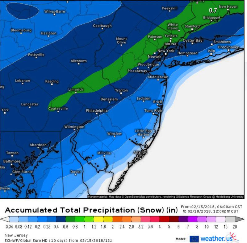
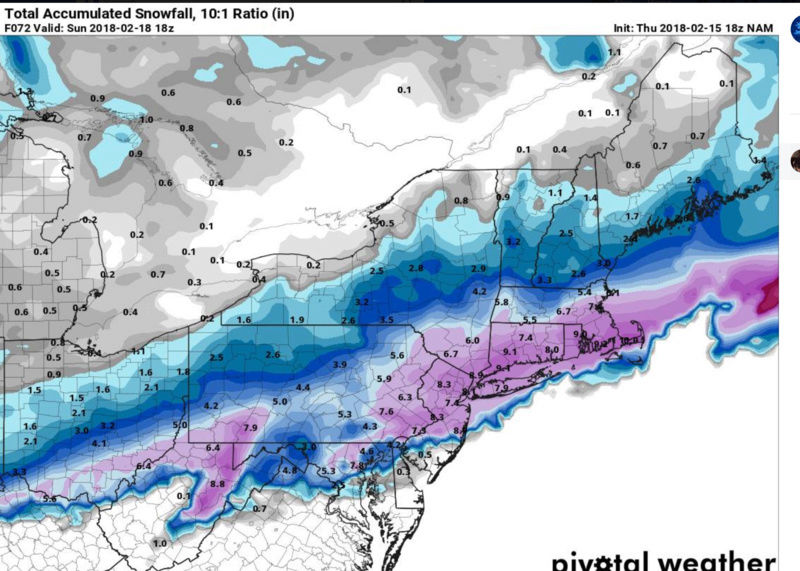
sroc4 wrote:18 z NAM would make everyone happy
Close call for LI, but with those kind of rates and this occurring at night, we should be okay.
_________________
-Alex Iannone-
aiannone- Senior Enthusiast - Mod
- Posts : 4815
Reputation : 92
Join date : 2013-01-07
Location : Saint James, LI (Northwest Suffolk Co.)
Re: FEB 17th-18th Snow? Sleet? Rain?
![]() by aiannone Thu Feb 15, 2018 3:48 pm
by aiannone Thu Feb 15, 2018 3:48 pm
_________________
-Alex Iannone-
aiannone- Senior Enthusiast - Mod
- Posts : 4815
Reputation : 92
Join date : 2013-01-07
Location : Saint James, LI (Northwest Suffolk Co.)
Re: FEB 17th-18th Snow? Sleet? Rain?
![]() by docstox12 Thu Feb 15, 2018 3:48 pm
by docstox12 Thu Feb 15, 2018 3:48 pm
sroc4 wrote:18 z NAM would make everyone happy
Veeeery happy with 8 inches on this map in the HV!!! No mixing worries up here!

docstox12- Wx Statistician Guru
- Posts : 8530
Reputation : 222
Join date : 2013-01-07
Age : 73
Location : Monroe NY
Re: FEB 17th-18th Snow? Sleet? Rain?
![]() by aiannone Thu Feb 15, 2018 3:49 pm
by aiannone Thu Feb 15, 2018 3:49 pm
_________________
-Alex Iannone-
aiannone- Senior Enthusiast - Mod
- Posts : 4815
Reputation : 92
Join date : 2013-01-07
Location : Saint James, LI (Northwest Suffolk Co.)
Re: FEB 17th-18th Snow? Sleet? Rain?
![]() by aiannone Thu Feb 15, 2018 3:50 pm
by aiannone Thu Feb 15, 2018 3:50 pm
_________________
-Alex Iannone-
aiannone- Senior Enthusiast - Mod
- Posts : 4815
Reputation : 92
Join date : 2013-01-07
Location : Saint James, LI (Northwest Suffolk Co.)
Re: FEB 17th-18th Snow? Sleet? Rain?
![]() by Grselig Thu Feb 15, 2018 3:53 pm
by Grselig Thu Feb 15, 2018 3:53 pm
aiannone wrote:NWS afternoon packages for all NE offices are late. They may be conversing. No one's HWO or AFD has been updated yet
I lost my HWO this morning. Wayne (NNJ)

Grselig- Senior Enthusiast

- Posts : 1408
Reputation : 140
Join date : 2013-03-04
Age : 54
Location : Wayne NJ
Re: FEB 17th-18th Snow? Sleet? Rain?
![]() by aiannone Thu Feb 15, 2018 4:00 pm
by aiannone Thu Feb 15, 2018 4:00 pm

_________________
-Alex Iannone-
aiannone- Senior Enthusiast - Mod
- Posts : 4815
Reputation : 92
Join date : 2013-01-07
Location : Saint James, LI (Northwest Suffolk Co.)
Re: FEB 17th-18th Snow? Sleet? Rain?
![]() by essexcountypete Thu Feb 15, 2018 4:10 pm
by essexcountypete Thu Feb 15, 2018 4:10 pm
Math23x7 wrote:sroc4 wrote:There is a good chance north of the LIE vs south of the LIE will vary greatly here with thsis system if you live on LI
More specifically, the cutoff would be the hill across Brooklyn/Queens/Nassau/Suffolk. I have mentioned this before on this forum. James is very familiar with this, especially with the hill on Commonwealth Blvd in Glen Oaks north of Union Turnpike. Also, James knows about this hill as Great Neck South is not far from Community Drive. North of the L.I.E there is a sharp downhill going into Manhasset. At the bottom is a hospital.
At any rate, I could see the rain/snow line aligning with this hill over the weekend. Since I am now north of that hill here in Manhattan, I should be snowing longer than in Bellerose
We have a similar feature here in Essex County, and you will often see Eastern and Western Essex with a divided forecast. I live nearer the eastern half on the side the first mountain you hit coming from the east off the coastal plain (and it's actually called First Mountain). It will often rain here in Bloomfield, but as you head up the hill to Montclair, and even more so as you get up to Verona and West Orange at the top of First Mountain, it will remain snow.
Gotta love micro-climates.

essexcountypete- Pro Enthusiast

- Posts : 783
Reputation : 12
Join date : 2013-12-09
Location : Bloomfield, NJ
Re: FEB 17th-18th Snow? Sleet? Rain?
![]() by aiannone Thu Feb 15, 2018 4:13 pm
by aiannone Thu Feb 15, 2018 4:13 pm
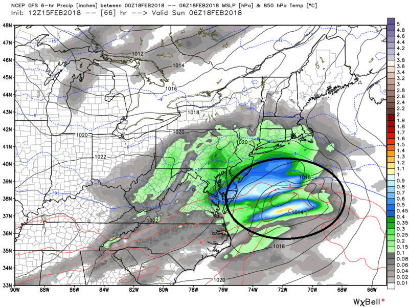
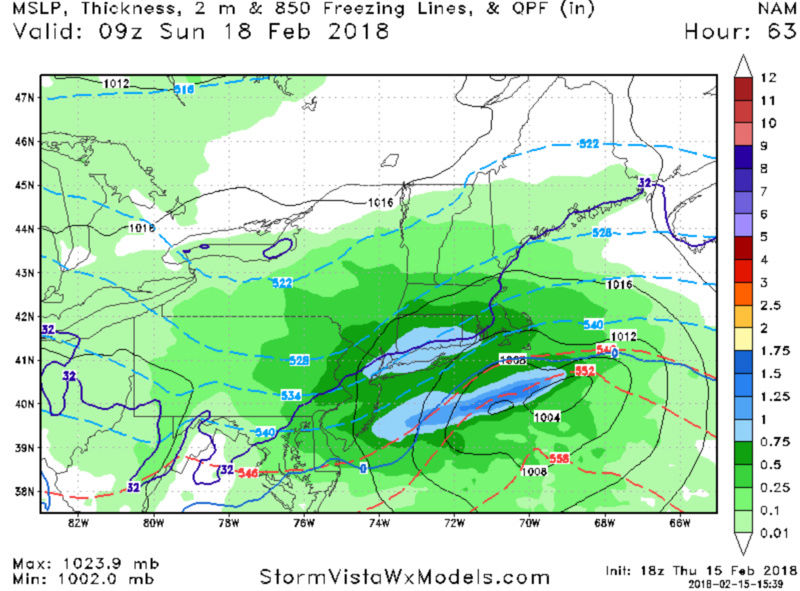
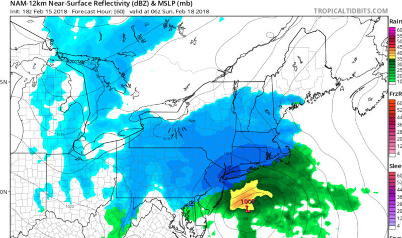
Looking at the passing low Saturday night, latest analysis of model
runs shows a deeper low, further north per nam/wrf when compared to
GFS, ECMWF and Canadian NH. Thus QPF is more robust. Assuming this
is an outlier, which would result in lower qpf amounts, then
attention turns to Ptype. Agree wholeheartedly with previous shift`s
analysis, much of it below. Trend has been north, and warmer with
various guidance. So a hedge toward lower amounts right along the
coast.
The weaker GFS solution is likely due to its poor handling of cold
air damming east of the Appalachians as high pressure quickly races
to the east on Saturday. The location of the high is clearly not
ideal for damming, nor for a moderate to heavy snow event.
However, the fast development of the low along the Mid Atlantic
coast late Saturday afternoon, which quickly passes to the
southeast, may only result in a short period of weak onshore flow as
the high moves off the New England coast.
A SE flow along the coast is typically a snow to rain event, but in
this case a rain/snow mix at the onset may go to all snow somewhat
quickly as winds shift quickly to the NE. In addition, a deep-
layered W-SW flow does not look to erode the cold air aloft, with
the main question thus being the boundary layer temperature, through
about 1-2 kft.
With about quarter to half inch of liquid across the area (possibly
up to 3/4 of an inch??), there is the potential for advisory level
snows (2 to 4 inches) for much of the region. 3 to 6 north and west
of I95, with less near the coast.
Cannot rule out a low end warning event (around 6 inches). This
depends on exact track, as a further south track places highest QPF
along the coast. The best chance for this to occur would be along or
just inland from the coast due to the higher QPF forecast, provided
the event can be mainly in the form of snow. Temperatures are
forecast to be in the 20s inland and in the lower 30s along the
coast.
So in summation, 1 to 3 inches near the coast, 2 to 4 inches as you
head NW, with 3 to 6 across the interior. Highest amounts likely
across interior srn CT, New England. Collab with WPC, and
surrounding offices.
_________________
-Alex Iannone-
aiannone- Senior Enthusiast - Mod
- Posts : 4815
Reputation : 92
Join date : 2013-01-07
Location : Saint James, LI (Northwest Suffolk Co.)
Re: FEB 17th-18th Snow? Sleet? Rain?
![]() by aiannone Thu Feb 15, 2018 4:13 pm
by aiannone Thu Feb 15, 2018 4:13 pm
_________________
-Alex Iannone-
aiannone- Senior Enthusiast - Mod
- Posts : 4815
Reputation : 92
Join date : 2013-01-07
Location : Saint James, LI (Northwest Suffolk Co.)
Re: FEB 17th-18th Snow? Sleet? Rain?
![]() by aiannone Thu Feb 15, 2018 4:17 pm
by aiannone Thu Feb 15, 2018 4:17 pm

_________________
-Alex Iannone-
aiannone- Senior Enthusiast - Mod
- Posts : 4815
Reputation : 92
Join date : 2013-01-07
Location : Saint James, LI (Northwest Suffolk Co.)
Re: FEB 17th-18th Snow? Sleet? Rain?
![]() by aiannone Thu Feb 15, 2018 4:19 pm
by aiannone Thu Feb 15, 2018 4:19 pm

_________________
-Alex Iannone-
aiannone- Senior Enthusiast - Mod
- Posts : 4815
Reputation : 92
Join date : 2013-01-07
Location : Saint James, LI (Northwest Suffolk Co.)
Re: FEB 17th-18th Snow? Sleet? Rain?
![]() by aiannone Thu Feb 15, 2018 4:49 pm
by aiannone Thu Feb 15, 2018 4:49 pm
_________________
-Alex Iannone-
aiannone- Senior Enthusiast - Mod
- Posts : 4815
Reputation : 92
Join date : 2013-01-07
Location : Saint James, LI (Northwest Suffolk Co.)


RJB8525- Senior Enthusiast
- Posts : 1994
Reputation : 28
Join date : 2013-02-06
Age : 38
Location : Hackettstown, NJ
Page 2 of 15 • 1, 2, 3 ... 8 ... 15 ![]()
|
|
|