
 Search
March 7th Godzilla: 1st Call Snow Map
Page 11 of 24 •  1 ... 7 ... 10, 11, 12 ... 17 ... 24
 ![]()
Re: March 7th Godzilla: 1st Call Snow Map
![]() by Frank_Wx Tue Mar 06, 2018 11:30 am
by Frank_Wx Tue Mar 06, 2018 11:30 am
emokid51783 wrote:For the record, emokid map does not buy 18 inches in Jersey City....as much as Id like to dream
I will put your snow map in the maps thread. Thanks for posting
syosnow94 wrote:Frank_Wx wrote:hi-res RGEM
I wanna scream. How can the hi-res RGEM show 24” IMBY and other models 3” within 15 hours of the event. These models are actually pointless and make the entire field of meteorology a laughing stock.

See my new post above.
Frank_Wx- Godzilla Seeker

- Posts : 21305
Join date : 2013-01-05 -

Re: March 7th Godzilla: 1st Call Snow Map
![]() by jake732 Tue Mar 06, 2018 11:30 am
by jake732 Tue Mar 06, 2018 11:30 am
jake732- Pro Enthusiast

- Posts : 449
Join date : 2016-01-03 -
Re: March 7th Godzilla: 1st Call Snow Map
![]() by nutleyblizzard Tue Mar 06, 2018 11:31 am
by nutleyblizzard Tue Mar 06, 2018 11:31 am
Wow thats impressive! If UKIE and EURO hold their ground, I believe we can discount the GFS and 12k NAM.Frank_Wx wrote:hi-res RGEM

nutleyblizzard- Senior Enthusiast

- Posts : 1952
Reputation : 41
Join date : 2014-01-30
Age : 58
Location : Nutley, new jersey
Re: March 7th Godzilla: 1st Call Snow Map
![]() by Frank_Wx Tue Mar 06, 2018 11:31 am
by Frank_Wx Tue Mar 06, 2018 11:31 am
rb924119 wrote:Frank_Wx wrote:hi-res RGEM
I'm leery of the NYC and metro jackpot. You might get it in precip, but I don't think in snow.
It also will not be a 10:1 ratio.
I am still trying to figure out what to think

_________________
_______________________________________________________________________________________________________
CLICK HERE to view NJ Strong Snowstorm Classifications

Frank_Wx- Godzilla Seeker
- Posts : 21305
Reputation : 328
Join date : 2013-01-05
Age : 31
Location : Jersey City, NJ -


jake732- Pro Enthusiast
- Posts : 449
Reputation : 0
Join date : 2016-01-03
Location : lakewood, nj -
Re: March 7th Godzilla: 1st Call Snow Map
![]() by Frank_Wx Tue Mar 06, 2018 11:35 am
by Frank_Wx Tue Mar 06, 2018 11:35 am
_________________
_______________________________________________________________________________________________________
CLICK HERE to view NJ Strong Snowstorm Classifications
Frank_Wx- Godzilla Seeker
- Posts : 21305
Reputation : 328
Join date : 2013-01-05
Age : 31
Location : Jersey City, NJ -
Re: March 7th Godzilla: 1st Call Snow Map
![]() by dsix85 Tue Mar 06, 2018 11:37 am
by dsix85 Tue Mar 06, 2018 11:37 am
dsix85- Pro Enthusiast
- Posts : 349
Reputation : 8
Join date : 2014-01-01
Location : New York
Re: March 7th Godzilla: 1st Call Snow Map
![]() by billg315 Tue Mar 06, 2018 11:40 am
by billg315 Tue Mar 06, 2018 11:40 am
lglickman wrote:Can someone educate me please - How does one approach these various models and which ones are likely keying in on the right features of a complex system. In other words, how do you have a sense of whether the GFS is more correct than something like the RGEM, or Euro, etc... Seems like there is a good amount of support for higher snow totals closer to the coast, but then again the GFS and more recent NAM runs suggest maybe a further west solution.
There's a couple of answers to this (actually maybe more than a couple) and you may get varying opinions from various people.
1.) If you look at the overall dynamics of a system and the larger scale weather pattern (what are the 850 level temps, where is the H5 low, where is the jet streak in comparison to the trough, what is the trough tilt, where and how high is the ridging, where is the block, etc, etc,) and it doesn't match up with what the models are showing at the surface, or one model is way off base from the others, that may be a clue that you shouldn't take that model verbatim. You also have to consider very localized factors that the models may sometimes miss but that you know exist (look at last week's storm, the failure of the snow to stick in many areas was something the models weren't going to pick up on that well. You really needed to know what the surface conditions were leading up to the storm in various places and where the heaviest precip intensity would be). Which brings me to point two;
2.) Sometimes, you just have to have a gut feel based on your experience. If you follow weather for 5, 10, 15 or more years, especially in one place, you start to learn a lot about how storms typically behave in that region and what localized dynamics are at play. That then informs your opinion of what is more likely to happen, based on previous similar situations, based on your local geography, climatology etc. Sometimes your gut will be wrong, but sometimes you just need to trust it because its based on your observational experience. This gets to sroc's point the other day about how people who know an area very well can often offer weather analysis for that particular area that is superior to what they know about another region.
If you combine your gut/experience with a good look at all the data, you can sometimes sniff out what models are right and what ones are off the mark. But this is, ultimately an inexact science, so sometimes you just have to wait and see how it actually unfolds, as it happens. You can't always get it right in advance.

billg315- Advanced Forecaster - Mod

- Posts : 4469
Reputation : 185
Join date : 2015-01-24
Age : 50
Location : Flemington, NJ
Re: March 7th Godzilla: 1st Call Snow Map
![]() by billg315 Tue Mar 06, 2018 11:41 am
by billg315 Tue Mar 06, 2018 11:41 am
One other point, when all else fails trust Frank. He knows his stuff!
billg315- Advanced Forecaster - Mod
- Posts : 4469
Reputation : 185
Join date : 2015-01-24
Age : 50
Location : Flemington, NJ
Re: March 7th Godzilla: 1st Call Snow Map
![]() by SoulSingMG Tue Mar 06, 2018 11:44 am
by SoulSingMG Tue Mar 06, 2018 11:44 am


SoulSingMG- Senior Enthusiast
- Posts : 2853
Reputation : 74
Join date : 2013-12-11
Location : Long Island City, NY
Re: March 7th Godzilla: 1st Call Snow Map
![]() by Frank_Wx Tue Mar 06, 2018 11:44 am
by Frank_Wx Tue Mar 06, 2018 11:44 am
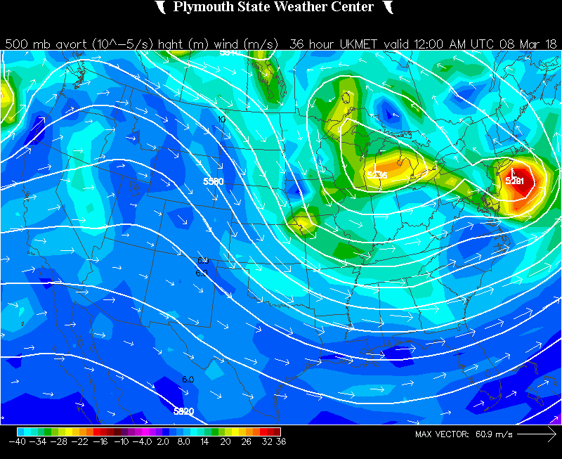
Frank_Wx wrote:The 12z UKMET looks fantastic.

_________________
_______________________________________________________________________________________________________
CLICK HERE to view NJ Strong Snowstorm Classifications
Frank_Wx- Godzilla Seeker
- Posts : 21305
Reputation : 328
Join date : 2013-01-05
Age : 31
Location : Jersey City, NJ -
Re: March 7th Godzilla: 1st Call Snow Map
![]() by Sanchize06 Tue Mar 06, 2018 11:45 am
by Sanchize06 Tue Mar 06, 2018 11:45 am

Sanchize06- Senior Enthusiast
- Posts : 1041
Reputation : 21
Join date : 2013-02-05
Location : Union Beach, NJ
Re: March 7th Godzilla: 1st Call Snow Map
![]() by rb924119 Tue Mar 06, 2018 11:47 am
by rb924119 Tue Mar 06, 2018 11:47 am
Frank_Wx wrote:rb924119 wrote:Frank_Wx wrote:hi-res RGEM
I'm leery of the NYC and metro jackpot. You might get it in precip, but I don't think in snow.
It also will not be a 10:1 ratio.
I am still trying to figure out what to think
Yeah, it definitely isn't easy ahha I think, though, the main low will be the one on the western flank - think of where your BEST pressure falls are going to be relative to your synoptic evolution. I also believe the eastern one is convective feedback (which can you blame the models?? Lol that convection is sick!!!!) secondly, when you're on the edge of that warm boundary and the vertical motion is so steep, I think you're going to be releasing so much latent heat from condensation that you end up with "sneet" (my word, just for sake of future arguments over ownership/first use lmfao), whereby it will be snowing and cold enough to snow, but there will be so much condensation going on from the steep and stupidly intense vertical motion that the vapor will condense on the snowflakes, and not only heavily rime them, but also during their overall size. So instead of having dendrites, you end up with something like sugar that takes a lot longer to stack up. By he same token, as that vertical motion becomes more slantwise further west, because you still have these same stupidly intense vertical velocities through the DGZ, THATS where the biggest totals will be. Because there isn't as much condensation going on; the precip is just being lofted further and then displaced, which keeps it out of the column-deep condensation processes. I've seen this before in these types of systems, which is why I'm so hesitant, and why I think north and west of I-95 jackpots bigtime. I definitely think this will be a thundersnow producer, though, and you have CSI and a crazy EPV gradient in the vertical superimposed nicely with your mid-level dry tongue. Most likely areas for this are northern half of NJ, LHV and back into EPA/east-central NY.
rb924119- Meteorologist

- Posts : 6890
Reputation : 194
Join date : 2013-02-06
Age : 32
Location : Greentown, Pa
Re: March 7th Godzilla: 1st Call Snow Map
![]() by Frank_Wx Tue Mar 06, 2018 11:48 am
by Frank_Wx Tue Mar 06, 2018 11:48 am
Frank_Wx wrote:Frank_Wx wrote:The 12z UKMET looks fantastic.

_________________
_______________________________________________________________________________________________________
CLICK HERE to view NJ Strong Snowstorm Classifications
Frank_Wx- Godzilla Seeker
- Posts : 21305
Reputation : 328
Join date : 2013-01-05
Age : 31
Location : Jersey City, NJ -
Re: March 7th Godzilla: 1st Call Snow Map
![]() by emokid51783 Tue Mar 06, 2018 11:48 am
by emokid51783 Tue Mar 06, 2018 11:48 am
dsix85 wrote:Hey Emo, you think eastern LI has a shot to get 6+?
Unlikely, but as always a 30m jog east, which is always possible in nowcasting mode, puts it into play
emokid51783- Posts : 144
Reputation : 5
Join date : 2013-12-12
Age : 40
Location : Jersey City Heights, NJ
Re: March 7th Godzilla: 1st Call Snow Map
![]() by dsix85 Tue Mar 06, 2018 11:49 am
by dsix85 Tue Mar 06, 2018 11:49 am
Last edited by dsix85 on Tue Mar 06, 2018 11:49 am; edited 1 time in total
dsix85- Pro Enthusiast
- Posts : 349
Reputation : 8
Join date : 2014-01-01
Location : New York
Re: March 7th Godzilla: 1st Call Snow Map
![]() by Frank_Wx Tue Mar 06, 2018 11:49 am
by Frank_Wx Tue Mar 06, 2018 11:49 am
rb924119 wrote:Frank_Wx wrote:rb924119 wrote:Frank_Wx wrote:hi-res RGEM
I'm leery of the NYC and metro jackpot. You might get it in precip, but I don't think in snow.
It also will not be a 10:1 ratio.
I am still trying to figure out what to think
Yeah, it definitely isn't easy ahha I think, though, the main low will be the one on the western flank - think of where your BEST pressure falls are going to be relative to your synoptic evolution. I also believe the eastern one is convective feedback (which can you blame the models?? Lol that convection is sick!!!!) secondly, when you're on the edge of that warm boundary and the vertical motion is so steep, I think you're going to be releasing so much latent heat from condensation that you end up with "sneet" (my word, just for sake of future arguments over ownership/first use lmfao), whereby it will be snowing and cold enough to snow, but there will be so much condensation going on from the steep and stupidly intense vertical motion that the vapor will condense on the snowflakes, and not only heavily rime them, but also during their overall size. So instead of having dendrites, you end up with something like sugar that takes a lot longer to stack up. By he same token, as that vertical motion becomes more slantwise further west, because you still have these same stupidly intense vertical velocities through the DGZ, THATS where the biggest totals will be. Because there isn't as much condensation going on; the precip is just being lofted further and then displaced, which keeps it out of the column-deep condensation processes. I've seen this before in these types of systems, which is why I'm so hesitant, and why I think north and west of I-95 jackpots bigtime. I definitely think this will be a thundersnow producer, though, and you have CSI and a crazy EPV gradient in the vertical superimposed nicely with your mid-level dry tongue. Most likely areas for this are northern half of NJ, LHV and back into EPA/east-central NY.
Agree...
_________________
_______________________________________________________________________________________________________
CLICK HERE to view NJ Strong Snowstorm Classifications
Frank_Wx- Godzilla Seeker
- Posts : 21305
Reputation : 328
Join date : 2013-01-05
Age : 31
Location : Jersey City, NJ -
Re: March 7th Godzilla: 1st Call Snow Map
![]() by amugs Tue Mar 06, 2018 11:51 am
by amugs Tue Mar 06, 2018 11:51 am
FOR 10G ALEX?
_________________
Mugs
AKA:King: Snow Weenie
Self Proclaimed
WINTER 2014-15 : 55.12" +.02 for 6 coatings (avg. 35")
WINTER 2015-16 Total - 29.8" (Avg 35")
WINTER 2016-17 : 39.5" so far

amugs- Advanced Forecaster - Mod
- Posts : 15093
Reputation : 213
Join date : 2013-01-07
Age : 54
Location : Hillsdale,NJ
Re: March 7th Godzilla: 1st Call Snow Map
![]() by jimv45 Tue Mar 06, 2018 11:52 am
by jimv45 Tue Mar 06, 2018 11:52 am
jimv45- Senior Enthusiast
- Posts : 1168
Reputation : 36
Join date : 2013-09-20
Location : Hopewell jct.
Re: March 7th Godzilla: 1st Call Snow Map
![]() by sroc4 Tue Mar 06, 2018 11:52 am
by sroc4 Tue Mar 06, 2018 11:52 am
_________________
"In weather and in life, there's no winning and losing; there's only winning and learning."
WINTER 2012/2013 TOTALS 43.65"WINTER 2017/2018 TOTALS 62.85" WINTER 2022/2023 TOTALS 4.9"
WINTER 2013/2014 TOTALS 64.85"WINTER 2018/2019 TOTALS 14.25" WINTER 2023/2024 TOTALS 13.1"
WINTER 2014/2015 TOTALS 71.20"WINTER 2019/2020 TOTALS 6.35"
WINTER 2015/2016 TOTALS 35.00"WINTER 2020/2021 TOTALS 37.75"
WINTER 2016/2017 TOTALS 42.25"WINTER 2021/2022 TOTALS 31.65"

sroc4- Admin
- Posts : 8331
Reputation : 301
Join date : 2013-01-07
Location : Wading River, LI
Re: March 7th Godzilla: 1st Call Snow Map
![]() by amugs Tue Mar 06, 2018 11:59 am
by amugs Tue Mar 06, 2018 11:59 am

_________________
Mugs
AKA:King: Snow Weenie
Self Proclaimed
WINTER 2014-15 : 55.12" +.02 for 6 coatings (avg. 35")
WINTER 2015-16 Total - 29.8" (Avg 35")
WINTER 2016-17 : 39.5" so far
amugs- Advanced Forecaster - Mod
- Posts : 15093
Reputation : 213
Join date : 2013-01-07
Age : 54
Location : Hillsdale,NJ
Re: March 7th Godzilla: 1st Call Snow Map
![]() by mikeypizano Tue Mar 06, 2018 12:14 pm
by mikeypizano Tue Mar 06, 2018 12:14 pm
Wait, Mugs, is that precip map UKIE or CMC?

mikeypizano- Pro Enthusiast
- Posts : 1118
Reputation : 66
Join date : 2017-01-05
Age : 35
Location : Wilkes-Barre/Scranton, PA
Re: March 7th Godzilla: 1st Call Snow Map
![]() by SoulSingMG Tue Mar 06, 2018 12:18 pm
by SoulSingMG Tue Mar 06, 2018 12:18 pm

SoulSingMG- Senior Enthusiast
- Posts : 2853
Reputation : 74
Join date : 2013-12-11
Location : Long Island City, NY
Re: March 7th Godzilla: 1st Call Snow Map
![]() by Grselig Tue Mar 06, 2018 12:21 pm
by Grselig Tue Mar 06, 2018 12:21 pm
mikeypizano wrote:That UKIE... M-A-D-O-N-N-E!!!
Wait, Mugs, is that precip map UKIE or CMC?
Mikey, you can't MADONNE something if you don't know what it is!!!!!!!!!

Grselig- Senior Enthusiast
- Posts : 1408
Reputation : 140
Join date : 2013-03-04
Age : 54
Location : Wayne NJ
Re: March 7th Godzilla: 1st Call Snow Map
![]() by mikeypizano Tue Mar 06, 2018 12:23 pm
by mikeypizano Tue Mar 06, 2018 12:23 pm
Grselig wrote:mikeypizano wrote:That UKIE... M-A-D-O-N-N-E!!!
Wait, Mugs, is that precip map UKIE or CMC?
Mikey, you can't MADONNE something if you don't know what it is!!!!!!!!!
/me looks at pretty colors
MAAADDDOOOONE!!!!
Last edited by mikeypizano on Tue Mar 06, 2018 12:25 pm; edited 1 time in total
mikeypizano- Pro Enthusiast
- Posts : 1118
Reputation : 66
Join date : 2017-01-05
Age : 35
Location : Wilkes-Barre/Scranton, PA
Re: March 7th Godzilla: 1st Call Snow Map
![]() by WeatherBob Tue Mar 06, 2018 12:23 pm
by WeatherBob Tue Mar 06, 2018 12:23 pm

WeatherBob- Meteorologist
- Posts : 683
Reputation : 83
Join date : 2013-12-13
Location : Caldwell, NJ - NW Essex County - Altitude 500 FT
Re: March 7th Godzilla: 1st Call Snow Map
![]() by sroc4 Tue Mar 06, 2018 12:24 pm
by sroc4 Tue Mar 06, 2018 12:24 pm
mikeypizano wrote:That UKIE... M-A-D-O-N-N-E!!!
Wait, Mugs, is that precip map UKIE or CMC?
Lol CMc. The question is did he mean to post the cmc or ukie?
_________________
"In weather and in life, there's no winning and losing; there's only winning and learning."
WINTER 2012/2013 TOTALS 43.65"WINTER 2017/2018 TOTALS 62.85" WINTER 2022/2023 TOTALS 4.9"
WINTER 2013/2014 TOTALS 64.85"WINTER 2018/2019 TOTALS 14.25" WINTER 2023/2024 TOTALS 13.1"
WINTER 2014/2015 TOTALS 71.20"WINTER 2019/2020 TOTALS 6.35"
WINTER 2015/2016 TOTALS 35.00"WINTER 2020/2021 TOTALS 37.75"
WINTER 2016/2017 TOTALS 42.25"WINTER 2021/2022 TOTALS 31.65"
sroc4- Admin
- Posts : 8331
Reputation : 301
Join date : 2013-01-07
Location : Wading River, LI
Page 11 of 24 • 1 ... 7 ... 10, 11, 12 ... 17 ... 24 ![]()