Tracking Another Possible Godzilla Mon-Tues, March 12th-13th
+34
Dunnzoo
jake732
Quietace
hurrysundown23
Radz
Taffy
adamfitz1969
heehaw453
CPcantmeasuresnow
frank 638
jimv45
Grselig
docstox12
amugs
aiannone
hyde345
jmanley32
SoulSingMG
algae888
mikeypizano
weatherwatchermom
Carter bk
SENJsnowman
gigs68
nutleyblizzard
Frank_Wx
rb924119
Dtone
skinsfan1177
SNOW MAN
cooladi
oldtimer
billg315
sroc4
38 posters
Page 1 of 13
Page 1 of 13 • 1, 2, 3 ... 11, 12, 13 
 Tracking Another Possible Godzilla Mon-Tues, March 12th-13th
Without question this sucka is gaining momentum. And the NW trends are real. When looking at the globals the GFS I believe is actually leading the way ovr the Euro. Lets quickly look at H 5 and compare the subtle, yet very important differences that will either pull the surface low track on or just SE of the 70/40 BM or keep the track further S&E of the BM.
There are two troughs to pay attention to. 1) the steering trough dropping in from the north, and 2) the main trough that is generation our storm system to the south. How it plays out will be about main trough axis orientation, (when and where), relative to the steering trough position.
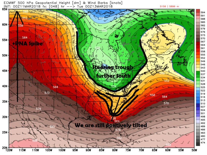
Lets take a look at the Euro vs the GFS valid 00z March 13th. Notice we are under 48hrs yet there are these subtle yet vitally important differences still. Notice in the first images, the Euro, the main trough orientation is still positively tilted, and the take notice where the steering trough is positioned. The result of a more positively tilted trough at this position, and a steering trough a tad to far south is a storm track that is more NE and well S&E of the BM.

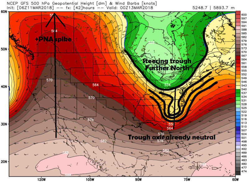
However; on the GFS, the main trough axis is already tilted to neutral because the steering trough is a tad further N allowing for heights to increase faster out ahead of the main trough axis. The result is higher heights means a strom track oriented more N to NNE and a track closer to the BM.

So which one is right? Well for now if you look at some of the hi res short range models, ie: the RGEM and 1k/3k NAM, they both agree with the GFS on main track orientation relative to the steering trough by 00z March 13th

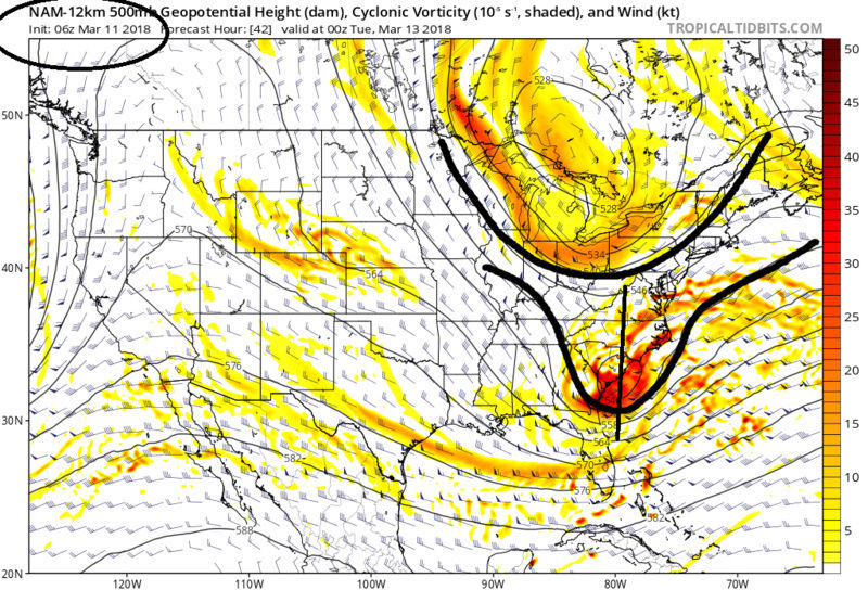
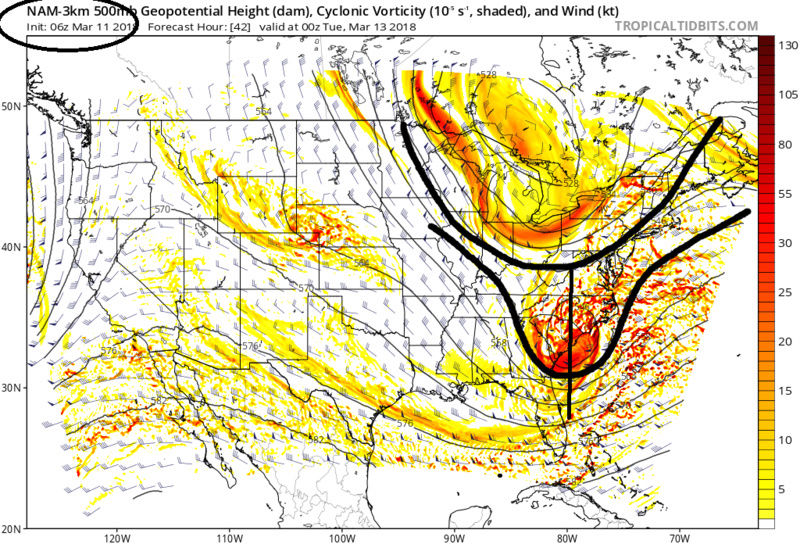
The Euro seems to be playing catchup with the NW trend. More than likely its the improved trend of the +PNA ridge in the west that has allowed for the delay in the arrival of the N energy/steering rough such that we can raise heights appropriately along the coast to bring the LP up. Watch the hi res models today and tonight for changes to the Main trough axis and position relative to the steering trough position. Another thing to watch is when the Main trough actually closes off. The 3K NAM closes it off near the Va/NC coast which tilts the main trough axis negative sooner causing a phase with the steering trough sooner and a much more potent storm and track even further N&W. The 12k NAM closes off H5 of the Main trough much later so the trough axis tilts neg later so the storm track is a tad further S&E relative to the 3K.
I fully expect further shifts N&W to the storm track today and tonight on the models. How far though?
There are two troughs to pay attention to. 1) the steering trough dropping in from the north, and 2) the main trough that is generation our storm system to the south. How it plays out will be about main trough axis orientation, (when and where), relative to the steering trough position.
Lets take a look at the Euro vs the GFS valid 00z March 13th. Notice we are under 48hrs yet there are these subtle yet vitally important differences still. Notice in the first images, the Euro, the main trough orientation is still positively tilted, and the take notice where the steering trough is positioned. The result of a more positively tilted trough at this position, and a steering trough a tad to far south is a storm track that is more NE and well S&E of the BM.


However; on the GFS, the main trough axis is already tilted to neutral because the steering trough is a tad further N allowing for heights to increase faster out ahead of the main trough axis. The result is higher heights means a strom track oriented more N to NNE and a track closer to the BM.


So which one is right? Well for now if you look at some of the hi res short range models, ie: the RGEM and 1k/3k NAM, they both agree with the GFS on main track orientation relative to the steering trough by 00z March 13th


The Euro seems to be playing catchup with the NW trend. More than likely its the improved trend of the +PNA ridge in the west that has allowed for the delay in the arrival of the N energy/steering rough such that we can raise heights appropriately along the coast to bring the LP up. Watch the hi res models today and tonight for changes to the Main trough axis and position relative to the steering trough position. Another thing to watch is when the Main trough actually closes off. The 3K NAM closes it off near the Va/NC coast which tilts the main trough axis negative sooner causing a phase with the steering trough sooner and a much more potent storm and track even further N&W. The 12k NAM closes off H5 of the Main trough much later so the trough axis tilts neg later so the storm track is a tad further S&E relative to the 3K.
I fully expect further shifts N&W to the storm track today and tonight on the models. How far though?
_________________
"In weather and in life, there's no winning and losing; there's only winning and learning."
WINTER 2012/2013 TOTALS 43.65"WINTER 2017/2018 TOTALS 62.85" WINTER 2022/2023 TOTALS 4.9"
WINTER 2013/2014 TOTALS 64.85"WINTER 2018/2019 TOTALS 14.25" WINTER 2023/2024 TOTALS 13.1"
WINTER 2014/2015 TOTALS 71.20"WINTER 2019/2020 TOTALS 6.35"
WINTER 2015/2016 TOTALS 35.00"WINTER 2020/2021 TOTALS 37.75"
WINTER 2016/2017 TOTALS 42.25"WINTER 2021/2022 TOTALS 31.65"

sroc4- Admin

- Posts : 8331
Reputation : 301
Join date : 2013-01-07
Location : Wading River, LI
 Re: Tracking Another Possible Godzilla Mon-Tues, March 12th-13th
Excellent write up Scott. As I said in the other thread, I think those who have somewhat realistic expectations about this event could be very happy. 3 days ago some models had this OTS off the Carolinas without us getting a flake, now it’s being called a “miss” by some if the models show us getting 1-3”. That tells you how far this has progressed. Lol

billg315- Advanced Forecaster - Mod

- Posts : 4462
Reputation : 185
Join date : 2015-01-24
Age : 50
Location : Flemington, NJ
 Re: Tracking Another Possible Godzilla Mon-Tues, March 12th-13th
NWS Has already posted WSW for New England You think they are leading more toward the Euro?
oldtimer- Senior Enthusiast

- Posts : 1103
Reputation : 14
Join date : 2013-01-16
Age : 78
Location : Port Jefferson Station Suffolk County
 Re: Tracking Another Possible Godzilla Mon-Tues, March 12th-13th
Excellent analysis as always! Just wish those models would get with the program, whatever it is, a whole lot quicker...
cooladi- Pro Enthusiast

- Posts : 185
Reputation : 2
Join date : 2013-01-08
Location : East Rockaway, NY 11518
 Re: Tracking Another Possible Godzilla Mon-Tues, March 12th-13th
Thank you for your reply billg. Hopefully I'll get some snow out of this.

SNOW MAN- Senior Enthusiast

- Posts : 1361
Reputation : 25
Join date : 2013-01-13
Age : 64
Location : Marshalls Creek Pa.
 Re: Tracking Another Possible Godzilla Mon-Tues, March 12th-13th
My sense with this is that it has been steadily trending N&W. This makes sense to me because of the overall pattern and because I think storms often tend to follow the trail blazed for them by prior storms (in a metaphorical sense). Once a certain storm track sets up, it often becomes the preferred track. The last two storms tracked close to the coast - not OTS so I would usually expect this to follow suit without a major intervening pattern change. Also the models have had a pretty consistent N&W trend this winter, so that also makes sense. I’m still not sure (at THIS moment) it gets close enough to give us a huge hit (though that is very much possible) but I do think everyone sees some accumulating snows (hence why realistic expectations are important to happiness here).

billg315- Advanced Forecaster - Mod

- Posts : 4462
Reputation : 185
Join date : 2015-01-24
Age : 50
Location : Flemington, NJ

skinsfan1177- Senior Enthusiast

- Posts : 4485
Reputation : 35
Join date : 2013-01-07
Age : 46
Location : Point Pleasant Boro
 Re: Tracking Another Possible Godzilla Mon-Tues, March 12th-13th
Crap I did lock the wrong thread by mistake. Thanks Janet
_________________
"In weather and in life, there's no winning and losing; there's only winning and learning."
WINTER 2012/2013 TOTALS 43.65"WINTER 2017/2018 TOTALS 62.85" WINTER 2022/2023 TOTALS 4.9"
WINTER 2013/2014 TOTALS 64.85"WINTER 2018/2019 TOTALS 14.25" WINTER 2023/2024 TOTALS 13.1"
WINTER 2014/2015 TOTALS 71.20"WINTER 2019/2020 TOTALS 6.35"
WINTER 2015/2016 TOTALS 35.00"WINTER 2020/2021 TOTALS 37.75"
WINTER 2016/2017 TOTALS 42.25"WINTER 2021/2022 TOTALS 31.65"

sroc4- Admin

- Posts : 8331
Reputation : 301
Join date : 2013-01-07
Location : Wading River, LI
 Re: Tracking Another Possible Godzilla Mon-Tues, March 12th-13th
Whoa what is going on. I left.to DC early Fri and havent been following since, this has becomea likely threat wow. I thought i might of had a better chance here.
Dtone- Wx Statistician Guru

- Posts : 1738
Reputation : 9
Join date : 2013-08-26
Location : Bronx, NY
 Re: Tracking Another Possible Godzilla Mon-Tues, March 12th-13th
Also note, this is a nighttime storm. Overnight temps have been below freeezing since Wed and will get to or below freezing Monday night. There will be NO sun issues, so what falls should (mostly) stick (unlike both of the prior storms where a lot of the falling snow wasn’t sticking cutting down on overall totals).

billg315- Advanced Forecaster - Mod

- Posts : 4462
Reputation : 185
Join date : 2015-01-24
Age : 50
Location : Flemington, NJ
 Re: Tracking Another Possible Godzilla Mon-Tues, March 12th-13th
FIVE LETTERS: S.R.E.F.S.!!!!!!!!!!!!!!!!!!!!!!!!!!!!!!!!!!!!!!!!!!!!!!!!! <3 <3 <3 <3 <3 <3 <3 <3 <3 <3 <3 <3 <3
rb924119- Meteorologist

- Posts : 6889
Reputation : 194
Join date : 2013-02-06
Age : 32
Location : Greentown, Pa
 Re: Tracking Another Possible Godzilla Mon-Tues, March 12th-13th
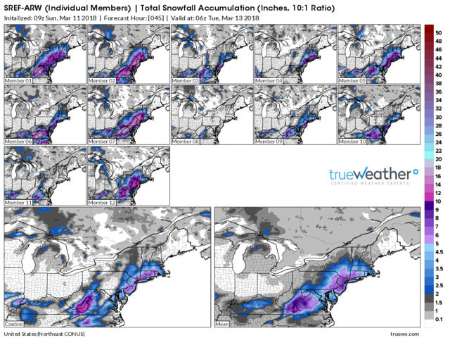
SREFS


_________________
_______________________________________________________________________________________________________
CLICK HERE to view NJ Strong Snowstorm Classifications
 Re: Tracking Another Possible Godzilla Mon-Tues, March 12th-13th
Wow what a jump west! You would think the NAM is going to comply shortly.Frank_Wx wrote:SREFS

nutleyblizzard- Senior Enthusiast

- Posts : 1952
Reputation : 41
Join date : 2014-01-30
Age : 58
Location : Nutley, new jersey
 Re: Tracking Another Possible Godzilla Mon-Tues, March 12th-13th
rb924119 wrote:FIVE LETTERS: S.R.E.F.S.!!!!!!!!!!!!!!!!!!!!!!!!!!!!!!!!!!!!!!!!!!!!!!!!! <3 <3 <3 <3 <3 <3 <3 <3 <3 <3 <3 <3 <3
What is the <3?

gigs68- Posts : 142
Reputation : 3
Join date : 2013-01-16
Location : Commack, NY (NW Suffolk)
 Re: Tracking Another Possible Godzilla Mon-Tues, March 12th-13th
A makeshift 'heart emoji' I believe...?
SENJsnowman- Senior Enthusiast

- Posts : 1186
Reputation : 61
Join date : 2017-01-06
Age : 51
Location : Bayville, NJ
 Re: Tracking Another Possible Godzilla Mon-Tues, March 12th-13th
SENJsnowman wrote:A makeshift 'heart emoji' I believe...?
Thanks I see it now

gigs68- Posts : 142
Reputation : 3
Join date : 2013-01-16
Location : Commack, NY (NW Suffolk)
 Re: Tracking Another Possible Godzilla Mon-Tues, March 12th-13th
I THINK THE NAM BOUTTA CALL THE SREFS AND RAISE THEM I THINK OMGGGGGGG!!!!!!!!!!!! H5 LOOKS RIDICULOUS!!!!!
rb924119- Meteorologist

- Posts : 6889
Reputation : 194
Join date : 2013-02-06
Age : 32
Location : Greentown, Pa
 Re: Tracking Another Possible Godzilla Mon-Tues, March 12th-13th
Shortwave is really amped. Looks like more northern/southern stream interaction going on earlier too.

nutleyblizzard- Senior Enthusiast

- Posts : 1952
Reputation : 41
Join date : 2014-01-30
Age : 58
Location : Nutley, new jersey
 Re: Tracking Another Possible Godzilla Mon-Tues, March 12th-13th
OH. MY. GOD. NAM IS GOING NUCLEAR HERE GOOD LORD I MUST BE IN HEAVEN!!!
rb924119- Meteorologist

- Posts : 6889
Reputation : 194
Join date : 2013-02-06
Age : 32
Location : Greentown, Pa
 Re: Tracking Another Possible Godzilla Mon-Tues, March 12th-13th
Trough much better aligned this run. 990 mb off the NC coast already!!!

nutleyblizzard- Senior Enthusiast

- Posts : 1952
Reputation : 41
Join date : 2014-01-30
Age : 58
Location : Nutley, new jersey
 Re: Tracking Another Possible Godzilla Mon-Tues, March 12th-13th
This is the last one for the season guys honestly. Unless u get a perfect storm in late march or aoril which is unlikely bring her home
Carter bk- Posts : 73
Reputation : 5
Join date : 2017-12-07
 Re: Tracking Another Possible Godzilla Mon-Tues, March 12th-13th
TWC gives NYC metro 2-4” and Long Island 4-8” More east less west in both cases.
NWS HAS NYC metro and Long Island 3-8”. Less west
Thoughts. Still 34 hours to go. I’ll have a map out this evening after the 12z runs are all done and analyzed. I say this afternoon at 4pm if trends hold the NWS will host advisories from the NYC metro west and watches east.
NWS HAS NYC metro and Long Island 3-8”. Less west
Thoughts. Still 34 hours to go. I’ll have a map out this evening after the 12z runs are all done and analyzed. I say this afternoon at 4pm if trends hold the NWS will host advisories from the NYC metro west and watches east.
Guest- Guest
 Re: Tracking Another Possible Godzilla Mon-Tues, March 12th-13th
Rb you posted 25min ago....and left us hanging 


weatherwatchermom- Senior Enthusiast

- Posts : 3733
Reputation : 77
Join date : 2014-11-25
Age : 60
Location : Hazlet Township, NJ
 Re: Tracking Another Possible Godzilla Mon-Tues, March 12th-13th
He’s doing it on purpose mom. Hopefully he saw the NAM and passed out
Guest- Guest
 Re: Tracking Another Possible Godzilla Mon-Tues, March 12th-13th
weatherwatchermom wrote:Rb you posted 25min ago....and left us hanging

He always does...

mikeypizano- Pro Enthusiast

- Posts : 1118
Reputation : 66
Join date : 2017-01-05
Age : 35
Location : Wilkes-Barre/Scranton, PA
Page 1 of 13 • 1, 2, 3 ... 11, 12, 13 
Page 1 of 13
Permissions in this forum:
You cannot reply to topics in this forum
 Home
Home