
 Search
Tracking Another Possible Godzilla Mon-Tues, March 12th-13th
Page 11 of 13 •  1, 2, 3 ... 10, 11, 12, 13
 ![]()
Re: Tracking Another Possible Godzilla Mon-Tues, March 12th-13th
![]() by nutleyblizzard Sun Mar 11, 2018 10:06 pm
by nutleyblizzard Sun Mar 11, 2018 10:06 pm
nutleyblizzard- Senior Enthusiast

- Posts : 1954
Join date : 2014-01-30
Re: Tracking Another Possible Godzilla Mon-Tues, March 12th-13th
![]() by aiannone Sun Mar 11, 2018 10:07 pm
by aiannone Sun Mar 11, 2018 10:07 pm
nutleyblizzard wrote:AS of hour 19 NAM is west of 18z.
Yet sfc QPF is a tick east of 18z at 26
aiannone- Senior Enthusiast - Mod

- Posts : 4815
Join date : 2013-01-07
Re: Tracking Another Possible Godzilla Mon-Tues, March 12th-13th
![]() by hurrysundown23 Sun Mar 11, 2018 10:07 pm
by hurrysundown23 Sun Mar 11, 2018 10:07 pm
hurrysundown23- Posts : 53
Reputation : 1
Join date : 2017-01-04
Location : Sayreville, NJ
Re: Tracking Another Possible Godzilla Mon-Tues, March 12th-13th
![]() by SoulSingMG Sun Mar 11, 2018 10:10 pm
by SoulSingMG Sun Mar 11, 2018 10:10 pm

SoulSingMG- Senior Enthusiast
- Posts : 2853
Reputation : 74
Join date : 2013-12-11
Location : Long Island City, NY
Re: Tracking Another Possible Godzilla Mon-Tues, March 12th-13th
![]() by jmanley32 Sun Mar 11, 2018 10:17 pm
by jmanley32 Sun Mar 11, 2018 10:17 pm
The snow barely makes it into the area, even further east but the LP looks odd, is it chasing convection? Will it actually be more expansive on western side.SoulSingMG wrote:00z NAM might just be the nail in this coffin.
Syo, SREF also has NYC 11-12.5 so close enough to a gofdzilla and warrents a WSW IF that were to solution but still think we are far from it and under 24 hrs here..

jmanley32- Senior Enthusiast
- Posts : 20535
Reputation : 108
Join date : 2013-12-12
Age : 43
Location : Yonkers, NY
Re: Tracking Another Possible Godzilla Mon-Tues, March 12th-13th
![]() by aiannone Sun Mar 11, 2018 10:20 pm
by aiannone Sun Mar 11, 2018 10:20 pm
_________________
-Alex Iannone-

aiannone- Senior Enthusiast - Mod
- Posts : 4815
Reputation : 92
Join date : 2013-01-07
Location : Saint James, LI (Northwest Suffolk Co.)
Re: Tracking Another Possible Godzilla Mon-Tues, March 12th-13th
![]() by Math23x7 Sun Mar 11, 2018 10:22 pm
by Math23x7 Sun Mar 11, 2018 10:22 pm
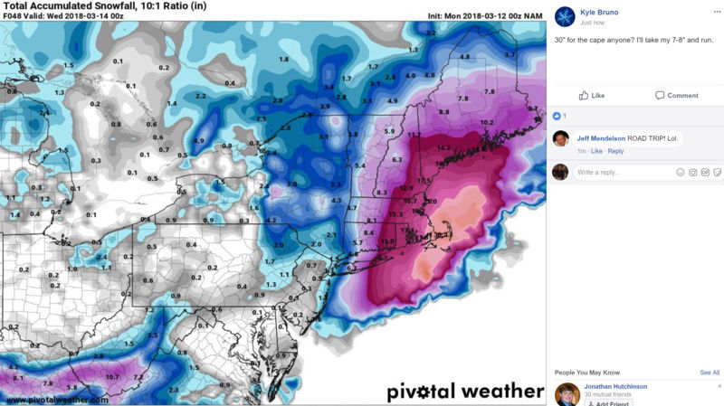
aiannone wrote: This could be similar to "Juno" NYC on west gets a couple inches while just east on LI into NE get's a significant snowfall
CPK got 9.8" from "Juno", Bellerose got 13" of snow, Islip got 24", Orient Point 30". I don't think any of those locations will get the snow they got from "Juno"
Math23x7- Wx Statistician Guru

- Posts : 2379
Reputation : 68
Join date : 2013-01-08
Re: Tracking Another Possible Godzilla Mon-Tues, March 12th-13th
![]() by jmanley32 Sun Mar 11, 2018 10:28 pm
by jmanley32 Sun Mar 11, 2018 10:28 pm
jmanley32- Senior Enthusiast
- Posts : 20535
Reputation : 108
Join date : 2013-12-12
Age : 43
Location : Yonkers, NY
Re: Tracking Another Possible Godzilla Mon-Tues, March 12th-13th
![]() by jmanley32 Sun Mar 11, 2018 10:28 pm
by jmanley32 Sun Mar 11, 2018 10:28 pm
jmanley32- Senior Enthusiast
- Posts : 20535
Reputation : 108
Join date : 2013-12-12
Age : 43
Location : Yonkers, NY
Re: Tracking Another Possible Godzilla Mon-Tues, March 12th-13th
![]() by mikeypizano Sun Mar 11, 2018 10:29 pm
by mikeypizano Sun Mar 11, 2018 10:29 pm
jmanley32 wrote:I am curious if Frank is gonna pull the plug? He must found a place hasnt been on all day.
He's busy setting up suicide nets...

mikeypizano- Pro Enthusiast

- Posts : 1118
Reputation : 66
Join date : 2017-01-05
Age : 35
Location : Wilkes-Barre/Scranton, PA
Re: Tracking Another Possible Godzilla Mon-Tues, March 12th-13th
![]() by billg315 Sun Mar 11, 2018 10:30 pm
by billg315 Sun Mar 11, 2018 10:30 pm

billg315- Advanced Forecaster - Mod
- Posts : 4483
Reputation : 185
Join date : 2015-01-24
Age : 50
Location : Flemington, NJ
Re: Tracking Another Possible Godzilla Mon-Tues, March 12th-13th
![]() by aiannone Sun Mar 11, 2018 10:30 pm
by aiannone Sun Mar 11, 2018 10:30 pm
jmanley32 wrote:You know I noticed on all the runs the system starts as rain for all.
That it does not
_________________
-Alex Iannone-
aiannone- Senior Enthusiast - Mod
- Posts : 4815
Reputation : 92
Join date : 2013-01-07
Location : Saint James, LI (Northwest Suffolk Co.)
Re: Tracking Another Possible Godzilla Mon-Tues, March 12th-13th
![]() by aiannone Sun Mar 11, 2018 10:31 pm
by aiannone Sun Mar 11, 2018 10:31 pm
_________________
-Alex Iannone-
aiannone- Senior Enthusiast - Mod
- Posts : 4815
Reputation : 92
Join date : 2013-01-07
Location : Saint James, LI (Northwest Suffolk Co.)
Re: Tracking Another Possible Godzilla Mon-Tues, March 12th-13th
![]() by jmanley32 Sun Mar 11, 2018 10:34 pm
by jmanley32 Sun Mar 11, 2018 10:34 pm
Wow one lousy inch, no chance this jumps back to where it was this morning, if it did that would be a huge feat.aiannone wrote:
jmanley32- Senior Enthusiast
- Posts : 20535
Reputation : 108
Join date : 2013-12-12
Age : 43
Location : Yonkers, NY
Re: Tracking Another Possible Godzilla Mon-Tues, March 12th-13th
![]() by jmanley32 Sun Mar 11, 2018 10:37 pm
by jmanley32 Sun Mar 11, 2018 10:37 pm
jmanley32- Senior Enthusiast
- Posts : 20535
Reputation : 108
Join date : 2013-12-12
Age : 43
Location : Yonkers, NY
Re: Tracking Another Possible Godzilla Mon-Tues, March 12th-13th
![]() by SoulSingMG Sun Mar 11, 2018 10:40 pm
by SoulSingMG Sun Mar 11, 2018 10:40 pm
jmanley32 wrote:Wow one lousy inch, no chance this jumps back to where it was this morning, if it did that would be a huge feat.aiannone wrote:
We're out of time, Jman. That northern vort just can't catch it in time to phase near where it's worthwhile for us
SoulSingMG- Senior Enthusiast
- Posts : 2853
Reputation : 74
Join date : 2013-12-11
Location : Long Island City, NY
Re: Tracking Another Possible Godzilla Mon-Tues, March 12th-13th
![]() by aiannone Sun Mar 11, 2018 10:41 pm
by aiannone Sun Mar 11, 2018 10:41 pm
_________________
-Alex Iannone-
aiannone- Senior Enthusiast - Mod
- Posts : 4815
Reputation : 92
Join date : 2013-01-07
Location : Saint James, LI (Northwest Suffolk Co.)
Re: Tracking Another Possible Godzilla Mon-Tues, March 12th-13th
![]() by jmanley32 Sun Mar 11, 2018 10:42 pm
by jmanley32 Sun Mar 11, 2018 10:42 pm
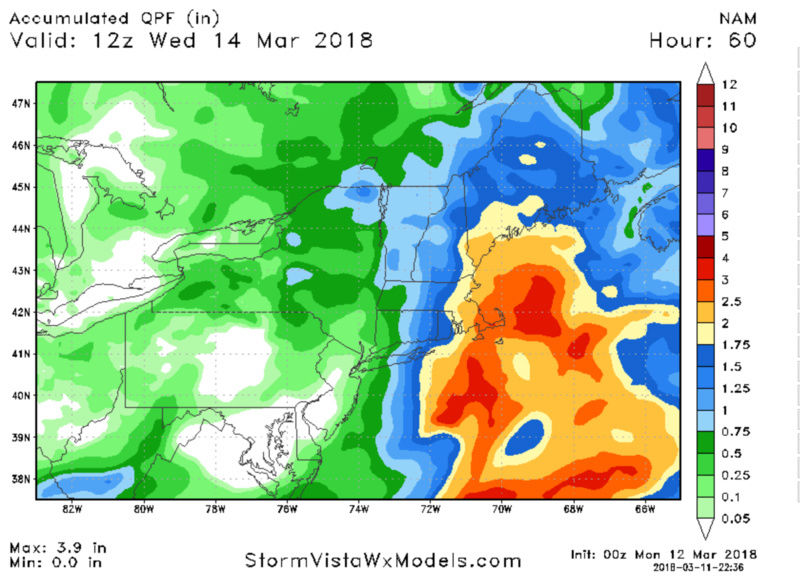
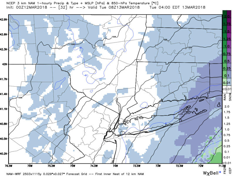
while it shows snow over the area for most of the night into about 12pm tues the qpf/mlsp map shows only a few hrs of precip not starting until much later than simulated radar, this the 3km nam. Is the model flawed here? Would explain the extremely low qpf.
jmanley32- Senior Enthusiast
- Posts : 20535
Reputation : 108
Join date : 2013-12-12
Age : 43
Location : Yonkers, NY
Re: Tracking Another Possible Godzilla Mon-Tues, March 12th-13th
![]() by oldtimer Sun Mar 11, 2018 10:46 pm
by oldtimer Sun Mar 11, 2018 10:46 pm
oldtimer- Senior Enthusiast
- Posts : 1103
Reputation : 14
Join date : 2013-01-16
Age : 78
Location : Port Jefferson Station Suffolk County
Re: Tracking Another Possible Godzilla Mon-Tues, March 12th-13th
![]() by jmanley32 Sun Mar 11, 2018 10:46 pm
by jmanley32 Sun Mar 11, 2018 10:46 pm
jmanley32- Senior Enthusiast
- Posts : 20535
Reputation : 108
Join date : 2013-12-12
Age : 43
Location : Yonkers, NY
Re: Tracking Another Possible Godzilla Mon-Tues, March 12th-13th
![]() by jmanley32 Sun Mar 11, 2018 10:47 pm
by jmanley32 Sun Mar 11, 2018 10:47 pm
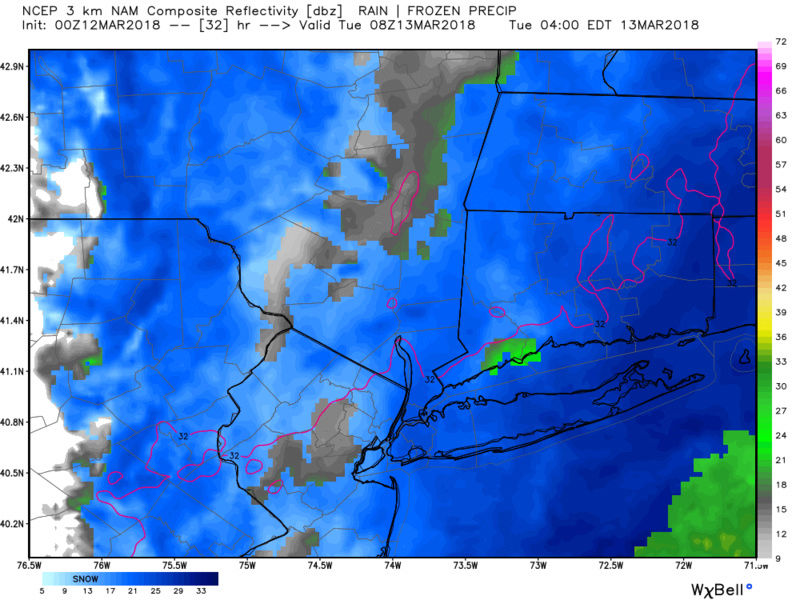
And most of eatern mass sees 20-30 inches....this makes me cryoldtimer wrote:Wow Alex Twin Forks getting nice dump
jmanley32- Senior Enthusiast
- Posts : 20535
Reputation : 108
Join date : 2013-12-12
Age : 43
Location : Yonkers, NY
Re: Tracking Another Possible Godzilla Mon-Tues, March 12th-13th
![]() by billg315 Sun Mar 11, 2018 10:47 pm
by billg315 Sun Mar 11, 2018 10:47 pm
billg315- Advanced Forecaster - Mod
- Posts : 4483
Reputation : 185
Join date : 2015-01-24
Age : 50
Location : Flemington, NJ
Re: Tracking Another Possible Godzilla Mon-Tues, March 12th-13th
![]() by jmanley32 Sun Mar 11, 2018 10:48 pm
by jmanley32 Sun Mar 11, 2018 10:48 pm
Yep GN all, was nice tracking nothing LOLSoulSingMG wrote:jmanley32 wrote:Wow one lousy inch, no chance this jumps back to where it was this morning, if it did that would be a huge feat.aiannone wrote:
We're out of time, Jman. That northern vort just can't catch it in time to phase near where it's worthwhile for us
jmanley32- Senior Enthusiast
- Posts : 20535
Reputation : 108
Join date : 2013-12-12
Age : 43
Location : Yonkers, NY
Re: Tracking Another Possible Godzilla Mon-Tues, March 12th-13th
![]() by SENJsnowman Sun Mar 11, 2018 10:50 pm
by SENJsnowman Sun Mar 11, 2018 10:50 pm
jmanley32 wrote:Guys I noted something interesting the qpf and mslp map does not match the simulated radar at all
while it shows snow over the area for most of the night into about 12pm tues the qpf/mlsp map shows only a few hrs of precip not starting until much later than simulated radar, this the 3km nam. Is the model flawed here? Would explain the extremely low qpf.
JMan, I like the way you are holding these models to task if what they output doesn't match what the input says it should. All winter long, when that has happened, the model output has ended wronger than hell.
Is that happening here? Ha ha, beats me!
(FYI- that's totally meant as a compliment)
Last edited by SENJsnowman on Sun Mar 11, 2018 10:52 pm; edited 1 time in total
SENJsnowman- Senior Enthusiast
- Posts : 1189
Reputation : 61
Join date : 2017-01-06
Age : 51
Location : Bayville, NJ
Re: Tracking Another Possible Godzilla Mon-Tues, March 12th-13th
![]() by jmanley32 Sun Mar 11, 2018 10:51 pm
by jmanley32 Sun Mar 11, 2018 10:51 pm
Maybe, i dont see this going west its been progressively going east since this morning, who knows maybe will miss eastern NE too. Hopefully if we dont see it I dont want them too for sure.billg315 wrote:JMan you are right. The NAM shows prolonged light to even at times moderate snow over NJ/NYC tomorrow night but virtually no accumulated precip. I would toss most of these accumulation maps right now (they’re usually ridiculously wrong and wildly fluctuate anyway) and focus on the storm track and projected precipitation field. Note the NWS forecast is higher than what is shown on those maps.
jmanley32- Senior Enthusiast
- Posts : 20535
Reputation : 108
Join date : 2013-12-12
Age : 43
Location : Yonkers, NY
Re: Tracking Another Possible Godzilla Mon-Tues, March 12th-13th
![]() by billg315 Sun Mar 11, 2018 10:53 pm
by billg315 Sun Mar 11, 2018 10:53 pm
1. If you’re expecting Godzilla it will probably be a disappointment because that seems a stretch for most people with this, but if you can be happy with a 2-4/3-5 snowfall you may just be happy with what you get;
2. We all woke up last Wednesday to a 30-50 mile shift in the low track. These things do happen - sometimes for better sometimes for worse in the final 24 hours, so nothing is off the table until tomorrow afternoon when this thing is actually forming.
billg315- Advanced Forecaster - Mod
- Posts : 4483
Reputation : 185
Join date : 2015-01-24
Age : 50
Location : Flemington, NJ
Re: Tracking Another Possible Godzilla Mon-Tues, March 12th-13th
![]() by jmanley32 Sun Mar 11, 2018 10:53 pm
by jmanley32 Sun Mar 11, 2018 10:53 pm
I am not holding onto anything, but to me it seems like theres a flaw within the same model and its own run. If this is not to be looked at themn why spend the money to make them, just make H5 and thats it, cuz thats all that seems to matter, not sure if you were jabbing me there or not but am not model hugging just saw a weird output from a model within a model.SENJsnowman wrote:jmanley32 wrote:Guys I noted something interesting the qpf and mslp map does not match the simulated radar at all
while it shows snow over the area for most of the night into about 12pm tues the qpf/mlsp map shows only a few hrs of precip not starting until much later than simulated radar, this the 3km nam. Is the model flawed here? Would explain the extremely low qpf.
JMan, I like the way you are holding these models to task if what they output doesn't match what the input says it should. All winter long, when that has happened, the model output has ended wronger than hell.
Is that happening here? Ha ha, beats me!
(FYI- that's totally meant as a compliment)
Updated: Oh okay, I wasnt sure how to take it.
Do I think it's wrong, yes!
jmanley32- Senior Enthusiast
- Posts : 20535
Reputation : 108
Join date : 2013-12-12
Age : 43
Location : Yonkers, NY
Sponsored content
Page 11 of 13 • 1, 2, 3 ... 10, 11, 12, 13 ![]()