2018 Hurricane Season
+26
Vinnydula
Math23x7
bobjohnsonforthehall
larryrock72
oldtimer
Grselig
billg315
Joe Snow
nutleyblizzard
Radz
Frank_Wx
jwalsh
Sanchize06
Dunnzoo
weatherwatchermom
rb924119
algae888
frank 638
skinsfan1177
amugs
GreyBeard
SoulSingMG
Quietace
Snow88
sroc4
jmanley32
30 posters
Page 17 of 18
Page 17 of 18 •  1 ... 10 ... 16, 17, 18
 Re: 2018 Hurricane Season
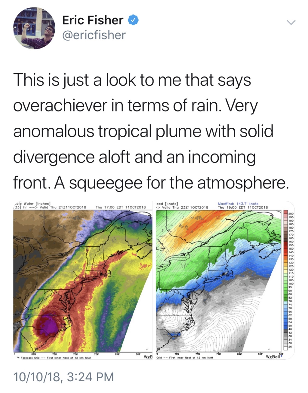
don't be surprised to see stronger effects up here than expected. Especially rain wise. Also remember banding has a lot tornados potential.SoulSingMG wrote:FLASH FLOOD WATCH just issued area-wide for NYC Metro ahead of intense cold front + tropical moisture from Michael.
jmanley32- Senior Enthusiast

- Posts : 20535
Join date : 2013-12-12
 Re: 2018 Hurricane Season
Lee Goldberg @ 4:17pm: "I am very concerned about flooding tomorrow afternoon."

SoulSingMG- Senior Enthusiast

- Posts : 2853
Reputation : 74
Join date : 2013-12-11
Location : Long Island City, NY
 Re: 2018 Hurricane Season
Greaat lol lets throw some wind in there somehow at least make it tiny bit interesting.

jmanley32- Senior Enthusiast

- Posts : 20535
Reputation : 108
Join date : 2013-12-12
Age : 43
Location : Yonkers, NY
 Re: 2018 Hurricane Season
No wind for youuuu, Jman! I see a wind hole right over Yonkers! Lol

SoulSingMG- Senior Enthusiast

- Posts : 2853
Reputation : 74
Join date : 2013-12-11
Location : Long Island City, NY
 Re: 2018 Hurricane Season
I doubt there will be any direct winds with Michael but some good thunderstorms are possible.SoulSingMG wrote:No wind for youuuu, Jman! I see a wind hole right over Yonkers! Lol

jmanley32- Senior Enthusiast

- Posts : 20535
Reputation : 108
Join date : 2013-12-12
Age : 43
Location : Yonkers, NY

SoulSingMG- Senior Enthusiast

- Posts : 2853
Reputation : 74
Join date : 2013-12-11
Location : Long Island City, NY
 Re: 2018 Hurricane Season
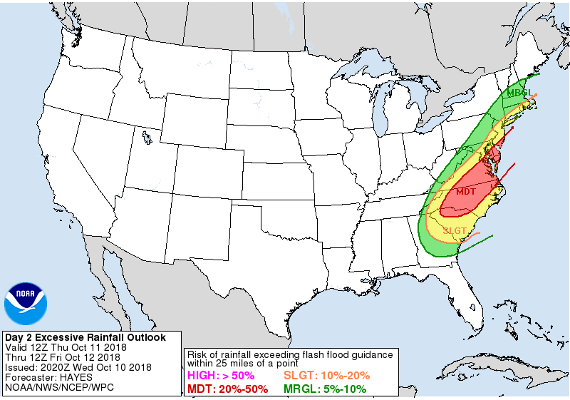
Where did you see this map? Latest I see on their Twitter has us marginal. Still only showing 1 to 2 inches on map. That's not excessive. At first I thought this was severe storms darn.

jmanley32- Senior Enthusiast

- Posts : 20535
Reputation : 108
Join date : 2013-12-12
Age : 43
Location : Yonkers, NY
 Re: 2018 Hurricane Season
That's old, Jman. Look at the NHC Twitter and you'll see the updated WPC rainfall maps.

SoulSingMG- Senior Enthusiast

- Posts : 2853
Reputation : 74
Join date : 2013-12-11
Location : Long Island City, NY
 Re: 2018 Hurricane Season
I'm surprised there's no severe weather threat with a tropical system and front.

jmanley32- Senior Enthusiast

- Posts : 20535
Reputation : 108
Join date : 2013-12-12
Age : 43
Location : Yonkers, NY
 Re: 2018 Hurricane Season
Quietace I hope you are ok??!!

weatherwatchermom- Senior Enthusiast

- Posts : 3793
Reputation : 78
Join date : 2014-11-25
Location : Hazlet Township, NJ
 Re: 2018 Hurricane Season
I hope Ryan is holding onto his hat!

dkodgis- Senior Enthusiast

- Posts : 2560
Reputation : 98
Join date : 2013-12-29
 Re: 2018 Hurricane Season
Just heard from Ryan, no power but he's safe. Unbelievable damage in the area...
_________________
Janet
Snowfall winter of 2023-2024 17.5"
Snowfall winter of 2022-2023 6.0"
Snowfall winter of 2021-2022 17.6" 1" sleet 2/25/22
Snowfall winter of 2020-2021 51.1"
Snowfall winter of 2019-2020 8.5"
Snowfall winter of 2018-2019 25.1"
Snowfall winter of 2017-2018 51.9"
Snowfall winter of 2016-2017 45.6"
Snowfall winter of 2015-2016 29.5"
Snowfall winter of 2014-2015 50.55"
Snowfall winter of 2013-2014 66.5"
Dunnzoo- Senior Enthusiast - Mod

- Posts : 4904
Reputation : 68
Join date : 2013-01-11
Age : 62
Location : Westwood, NJ
 Re: 2018 Hurricane Season
thank goodness!! Just heard this storm ranked 3rd for pressure tom is going to bring some tragic imagesDunnzoo wrote:Just heard from Ryan, no power but he's safe. Unbelievable damage in the area...

weatherwatchermom- Senior Enthusiast

- Posts : 3793
Reputation : 78
Join date : 2014-11-25
Location : Hazlet Township, NJ
 Re: 2018 Hurricane Season
Wow ya the pressure was crazy low. I saw some footage from landfall area. Nothing was standing still....everything was destroyed except the reinforced building the person filming was in I guess. These storms are becoming more numerous in hitting land each year it seems.

jmanley32- Senior Enthusiast

- Posts : 20535
Reputation : 108
Join date : 2013-12-12
Age : 43
Location : Yonkers, NY
 Re: 2018 Hurricane Season
The images from the international space station, GOES satellite loops, and videos from inside the eye of Michael are some of the best images of landfalling hurricanes ever produced, simply amazing and mesmerizing- unfortunately, today the images and drone videos of the path of destruction which will rival these in quality will however evoke a far different set of emotions...
Radz- Pro Enthusiast

- Posts : 1028
Reputation : 17
Join date : 2013-01-12
Location : Cortlandt Manor NY
 Re: 2018 Hurricane Season
6z HMON


Sanchize06- Senior Enthusiast

- Posts : 1041
Reputation : 21
Join date : 2013-02-05
Location : Union Beach, NJ
 Re: 2018 Hurricane Season
Just wow
_________________
"In weather and in life, there's no winning and losing; there's only winning and learning."
WINTER 2012/2013 TOTALS 43.65"WINTER 2017/2018 TOTALS 62.85" WINTER 2022/2023 TOTALS 4.9"
WINTER 2013/2014 TOTALS 64.85"WINTER 2018/2019 TOTALS 14.25" WINTER 2023/2024 TOTALS 13.1"
WINTER 2014/2015 TOTALS 71.20"WINTER 2019/2020 TOTALS 6.35"
WINTER 2015/2016 TOTALS 35.00"WINTER 2020/2021 TOTALS 37.75"
WINTER 2016/2017 TOTALS 42.25"WINTER 2021/2022 TOTALS 31.65"

sroc4- Admin

- Posts : 8354
Reputation : 302
Join date : 2013-01-07
Location : Wading River, LI
 Re: 2018 Hurricane Season
sroc4 wrote:Just wow
Feel sick after seeing this. Devastating

Grselig- Senior Enthusiast

- Posts : 1408
Reputation : 140
Join date : 2013-03-04
Age : 54
Location : Wayne NJ
 Re: 2018 Hurricane Season
Yeah saw the video on TV, just terrible. In our weather seems the flash flood watches needed to be into the northeast, not here, the flooding rains are all happening way north of here, not sure if we see much at all, even NHC has 1-2 at best for majority of area except for south jersey to about central jersey and just south of LI. Weird.

jmanley32- Senior Enthusiast

- Posts : 20535
Reputation : 108
Join date : 2013-12-12
Age : 43
Location : Yonkers, NY
 Re: 2018 Hurricane Season
Just devastating watching the destruction..having flashbacks to Sandy 

weatherwatchermom- Senior Enthusiast

- Posts : 3793
Reputation : 78
Join date : 2014-11-25
Location : Hazlet Township, NJ
 Re: 2018 Hurricane Season
Mexico Beach is no more and those who tried top ride out there are missing - Miami Dade Fire and Rescue on teh ground there said they aren't talking about the death toll. Scary to hear.
_________________
Mugs
AKA:King: Snow Weenie
Self Proclaimed
WINTER 2014-15 : 55.12" +.02 for 6 coatings (avg. 35")
WINTER 2015-16 Total - 29.8" (Avg 35")
WINTER 2016-17 : 39.5" so far

amugs- Advanced Forecaster - Mod

- Posts : 15095
Reputation : 213
Join date : 2013-01-07
Age : 54
Location : Hillsdale,NJ
 Re: 2018 Hurricane Season
rb924119 wrote:You know? Call me crazy, but I don’t think I buy intensification through landfall. In fact, I can see a plateauing and then start of a decay coming into landfall and my reason is the following:
If you look at pressure anomalies, you will see how there are strong negative anomalies rapidly overtaking the CONUS as the midwestern system continues advancing in the wake of the departing high. This will likely distort the lower-level convergence such that the core will not be able to maintain its current progression, even with the other favorable atmospheric conditions. Remember, the stronger these systems become, the more perfect the environment surrounding them needs to be in order to maintain and/or strengthen them further. In my opinion, I think this disruption in the lower-level pressure field will outweigh the environmental conditions as it approaches the coast, and lead to a plateauing and then late start at a decay prior to landfall. Nonetheless, it will still be a powerful and destructive storm, but in the end, think it will fall short of current progs. We shall certainly see, one way or the other.
Thinking back more on this, and about why I might have been looking at this the wrong way, it struck me: This system was DIFFERENT from other systems this season, and from other systems where I have used this similar thought process. Obviously each system is different, but there were a few this season where I distinctly remember successfully using this parameter as a metric to gauge if a system would strengthen or not as it approached the U.S. mainland, or wherever else their destinations were (some were just out in the open water). Anyway, these previous systems were all headed directly into broad regions of anomalously high pressure, thereby experiencing enhanced lower-level convergence. HOWEVER, their forward speeds remained relatively unchanged as they progressed. Michael, though; was different. Even though Michael was headed into a region with significantly lower than normal pressure anomalies across the eastern CONUS, its forward speed was steadily but rapidly INCREASING as it drew nearer to the U.S. Because of this, I hypothesize that this helped to overcome the impact that I originally expected **with regard to the role of lower-level pressure anomalies interfering with the lower-level convergence around the storm's circulation**, as the increasing forward speed helped to negate the lack of lower-level convergence/divergence caused by the system coming through the Central Plains. Now, the other environmental conditions could have simply overwhelmed the surface, but I suspect not entirely, as again, the stronger these systems become, the more perfect their environment needs to be. However, this will be an interesting thought to test on future systems to see if it might have merit. Anyway, a little post-storm reflection never hurts.
rb924119- Meteorologist

- Posts : 6928
Reputation : 194
Join date : 2013-02-06
Age : 32
Location : Greentown, Pa
 Re: 2018 Hurricane Season
rb924119 wrote:rb924119 wrote:You know? Call me crazy, but I don’t think I buy intensification through landfall. In fact, I can see a plateauing and then start of a decay coming into landfall and my reason is the following:
If you look at pressure anomalies, you will see how there are strong negative anomalies rapidly overtaking the CONUS as the midwestern system continues advancing in the wake of the departing high. This will likely distort the lower-level convergence such that the core will not be able to maintain its current progression, even with the other favorable atmospheric conditions. Remember, the stronger these systems become, the more perfect the environment surrounding them needs to be in order to maintain and/or strengthen them further. In my opinion, I think this disruption in the lower-level pressure field will outweigh the environmental conditions as it approaches the coast, and lead to a plateauing and then late start at a decay prior to landfall. Nonetheless, it will still be a powerful and destructive storm, but in the end, think it will fall short of current progs. We shall certainly see, one way or the other.
Thinking back more on this, and about why I might have been looking at this the wrong way, it struck me: This system was DIFFERENT from other systems this season, and from other systems where I have used this similar thought process. Obviously each system is different, but there were a few this season where I distinctly remember successfully using this parameter as a metric to gauge if a system would strengthen or not as it approached the U.S. mainland, or wherever else their destinations were (some were just out in the open water). Anyway, these previous systems were all headed directly into broad regions of anomalously high pressure, thereby experiencing enhanced lower-level convergence. HOWEVER, their forward speeds remained relatively unchanged as they progressed. Michael, though; was different. Even though Michael was headed into a region with significantly lower than normal pressure anomalies across the eastern CONUS, its forward speed was steadily but rapidly INCREASING as it drew nearer to the U.S. Because of this, I hypothesize that this helped to overcome the impact that I originally expected **with regard to the role of lower-level pressure anomalies interfering with the lower-level convergence around the storm's circulation**, as the increasing forward speed helped to negate the lack of lower-level convergence/divergence caused by the system coming through the Central Plains. Now, the other environmental conditions could have simply overwhelmed the surface, but I suspect not entirely, as again, the stronger these systems become, the more perfect their environment needs to be. However, this will be an interesting thought to test on future systems to see if it might have merit. Anyway, a little post-storm reflection never hurts.
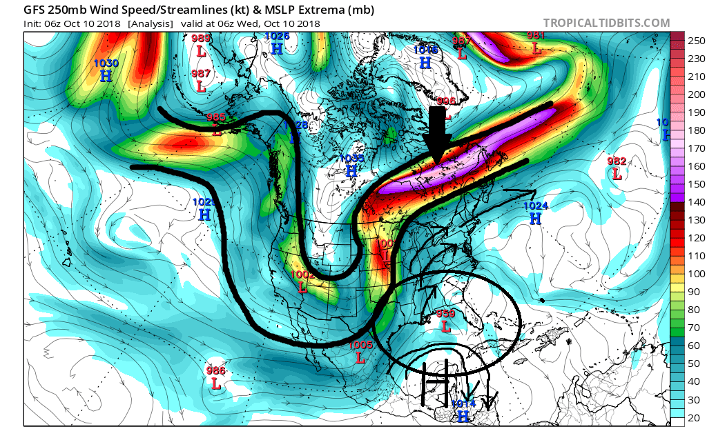
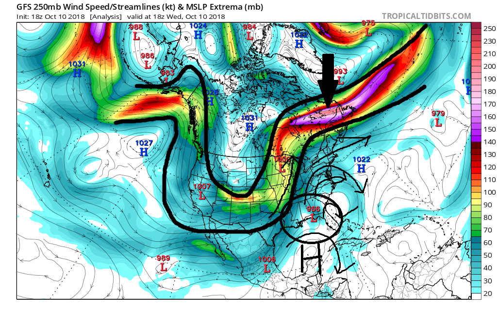
I know its probably multifactorial, but I honestly believe that the large scale upper level environment is the real reason he cont to strengthen all the way through landfall. Looking at the last two frames of the GFS before landfall you can see the shear magnitude of the mean trough and the associated jet streak. I mean it literally involves all of North America originating in the N tip of Alaska running south all the way into the N fringes of Mexico, back north will into N and Central eastern Canada; extending well out into the N Atlantic. The jet streak alone is approx. 3000miles long give or take. Also Notice how the JS is actually strengthening as Mike comes ashore; not weakening, and the trough itself is in a neutral to maybe slight neg orientation. The shear size and scope/magnitude of the mean trough/jet streak complex, I believe, created an extremely favorable region of upper level divergence(R Rear quad), the center of which appears to be directly over head Mike such that it had to respond by lowering pressure. Again its a situation where size really did matter along with location location location of Mike. Of course there were other factors as well, like the environment to the immediate N, E and S leading to good outflow to go along with he aforementioned conditions, but I think there were large scale features that easily were able to over ride some of the possible smaller scale inhibitory factors.
I also believe this large scale upper level divergence over top a large area surrounding Mike is why he initially persistently strengthened beyond the Yucatan straits despite being under moderate shear. Once the shear began to back off he steadily increased the speed at which he strengthened because the upper levels cont to improve all the way into the coast.
Anyway that's my two cents on the matter. Ray any thoughts on this theory?
_________________
"In weather and in life, there's no winning and losing; there's only winning and learning."
WINTER 2012/2013 TOTALS 43.65"WINTER 2017/2018 TOTALS 62.85" WINTER 2022/2023 TOTALS 4.9"
WINTER 2013/2014 TOTALS 64.85"WINTER 2018/2019 TOTALS 14.25" WINTER 2023/2024 TOTALS 13.1"
WINTER 2014/2015 TOTALS 71.20"WINTER 2019/2020 TOTALS 6.35"
WINTER 2015/2016 TOTALS 35.00"WINTER 2020/2021 TOTALS 37.75"
WINTER 2016/2017 TOTALS 42.25"WINTER 2021/2022 TOTALS 31.65"

sroc4- Admin

- Posts : 8354
Reputation : 302
Join date : 2013-01-07
Location : Wading River, LI
 Re: 2018 Hurricane Season
http://www.fox13news.com/news/florida-news/storm-chasers-abandon-truck-in-flood-during-live-stream-in-hurricane-michael
I watched a bit and then forwarded to where they said around 34 min..these guys are lucky to be alive!!!
I watched a bit and then forwarded to where they said around 34 min..these guys are lucky to be alive!!!

weatherwatchermom- Senior Enthusiast

- Posts : 3793
Reputation : 78
Join date : 2014-11-25
Location : Hazlet Township, NJ
 Re: 2018 Hurricane Season
Sroc..explained perfectly as usual! interesting perspective

weatherwatchermom- Senior Enthusiast

- Posts : 3793
Reputation : 78
Join date : 2014-11-25
Location : Hazlet Township, NJ
 Re: 2018 Hurricane Season
Scott, there is no question your points outlined above have merit, and can easily be used to substantiate the rapid strengthening. Much of them we had both acknowledged in discussion of one of your previous posts as Michael began strengthening. However, my hypothesis is based on the following train of thought: These systems are heat engines, which derive their energy from the ocean surface. Even if your engine is running perfectly, you have the proper fuel (warm water), if the injectors (lower-level convergence) aren’t working properly, what happens to your finely tuned engine? It won’t run properly, right? As you try to increase your RPM, the engine will sputter as it’s being starved for fuel (in this case, the fuel would be the feedback from W.I.S.H.E. processes. That’s how I was looking at this system, and I now have something to test next season  but there is no question that the points you outlined above could easily be why my thoughts were blown to smithereens haha
rb924119- Meteorologist

- Posts : 6928
Reputation : 194
Join date : 2013-02-06
Age : 32
Location : Greentown, Pa
Page 17 of 18 •  1 ... 10 ... 16, 17, 18
Page 17 of 18
Permissions in this forum:
You cannot reply to topics in this forum|
|
|

 Home
Home