FLORENCE: East Coast Threat or Does She Sleep With the Fishes?
+23
bobjohnsonforthehall
mwilli5783
Math23x7
jwalsh
frank 638
billg315
larryrock72
Dunnzoo
Radz
weatherwatchermom
nutleyblizzard
rb924119
Zhukov1945
SoulSingMG
amugs
Sanchize06
Frank_Wx
jmanley32
Joe Snow
algae888
Grselig
Quietace
sroc4
27 posters
Page 1 of 20
Page 1 of 20 • 1, 2, 3 ... 10 ... 20 
 FLORENCE: East Coast Threat or Does She Sleep With the Fishes?
I know its going to be hard but again try hard not to look beyond the next 2-3days for track or intensity. Every where from the Carolinas to a miss wide right is still in play.

There are multiple factors here that will be at play. For me some of the bigger items are becoming clear, ie: she is missing the first bus OTS, and the 500mb ridge will trap her and cont her path in a west to NW direction over the next few days; however, Florence's intensity in the next 3-5 days will become important. The reason being is that the influences of the steering layers of the atmosphere will change depending on her intensity. This means that even though the mean 500mb flow from such a strong ridge may be west NW, if Florence is a major hurricane then she will likely be influenced in her direction by some of the upper layers of the atmosphere as well. If the upper layers are in a different direction than the 500mb layer then her track will not be as simple as which direction is the ridge pushing her.
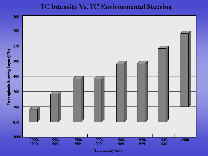
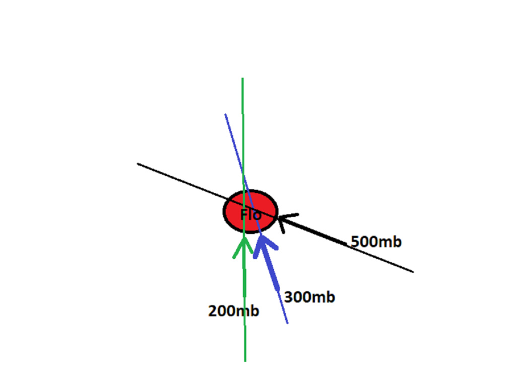
If she stays below a certain intensity then she will stay below the influences of certain layers of the atmosphere. If you are being pushed by one person in the back then you will move forward in the direction which the person is pushing you. However; if you are being pushed by 3 people all in slightly diff directions, all with slightly different forces, and all from slightly different heights on your body, then the direction for which you move ends up the sum of all the forces or vectors on your body; not just forward from the person pushing you in the back. Below is another simple example. In the below example pretend Flo is a major hurricane with a 930mb min central pressure. Flo is being acted upon by three diff forces; he 300mb has the strongest winds. Her direction will not simply be in the same direction the 500mb flow is pushing her even though the ridge is strong. Her movment is now influenced by other steering layers because of how strong her vortex is.
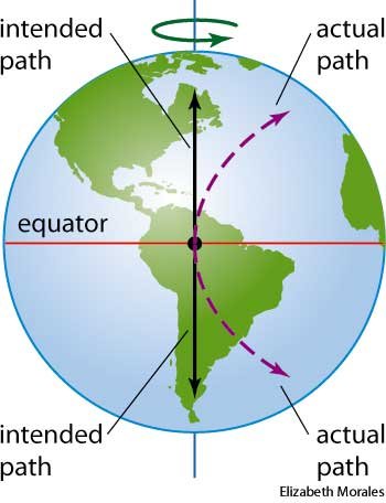
Combine this along with the natural Coriolis effect (an effect whereby a mass moving in a rotating system experiences a force (the Coriolis force ) acting perpendicular to the direction of motion and to the axis of rotation. On the earth, the effect tends to deflect moving objects to the right in the northern hemisphere ). NOTE: the further north away from the equator a system gets the more the Coriolis effect influences a system. This is why it is so hard to get a Trop system NOT to recurve at such high latitudes.
So keep this info in the back of your minds when looking at the models come in over the next several days. As she gains latitude and strength the tendency will be to turn right. What forces at the various layers of the atmosphere are acting upon her to prevent that from happening and cont to steer her more westerly towards the coast? Will it be enough to prevent her from recurving? These are things we just don't know yet.
WE TRACK!!!!

There are multiple factors here that will be at play. For me some of the bigger items are becoming clear, ie: she is missing the first bus OTS, and the 500mb ridge will trap her and cont her path in a west to NW direction over the next few days; however, Florence's intensity in the next 3-5 days will become important. The reason being is that the influences of the steering layers of the atmosphere will change depending on her intensity. This means that even though the mean 500mb flow from such a strong ridge may be west NW, if Florence is a major hurricane then she will likely be influenced in her direction by some of the upper layers of the atmosphere as well. If the upper layers are in a different direction than the 500mb layer then her track will not be as simple as which direction is the ridge pushing her.

If she stays below a certain intensity then she will stay below the influences of certain layers of the atmosphere. If you are being pushed by one person in the back then you will move forward in the direction which the person is pushing you. However; if you are being pushed by 3 people all in slightly diff directions, all with slightly different forces, and all from slightly different heights on your body, then the direction for which you move ends up the sum of all the forces or vectors on your body; not just forward from the person pushing you in the back. Below is another simple example. In the below example pretend Flo is a major hurricane with a 930mb min central pressure. Flo is being acted upon by three diff forces; he 300mb has the strongest winds. Her direction will not simply be in the same direction the 500mb flow is pushing her even though the ridge is strong. Her movment is now influenced by other steering layers because of how strong her vortex is.

Combine this along with the natural Coriolis effect (an effect whereby a mass moving in a rotating system experiences a force (the Coriolis force ) acting perpendicular to the direction of motion and to the axis of rotation. On the earth, the effect tends to deflect moving objects to the right in the northern hemisphere ). NOTE: the further north away from the equator a system gets the more the Coriolis effect influences a system. This is why it is so hard to get a Trop system NOT to recurve at such high latitudes.

So keep this info in the back of your minds when looking at the models come in over the next several days. As she gains latitude and strength the tendency will be to turn right. What forces at the various layers of the atmosphere are acting upon her to prevent that from happening and cont to steer her more westerly towards the coast? Will it be enough to prevent her from recurving? These are things we just don't know yet.
WE TRACK!!!!

_________________
"In weather and in life, there's no winning and losing; there's only winning and learning."
WINTER 2012/2013 TOTALS 43.65"WINTER 2017/2018 TOTALS 62.85" WINTER 2022/2023 TOTALS 4.9"
WINTER 2013/2014 TOTALS 64.85"WINTER 2018/2019 TOTALS 14.25" WINTER 2023/2024 TOTALS 13.1"
WINTER 2014/2015 TOTALS 71.20"WINTER 2019/2020 TOTALS 6.35"
WINTER 2015/2016 TOTALS 35.00"WINTER 2020/2021 TOTALS 37.75"
WINTER 2016/2017 TOTALS 42.25"WINTER 2021/2022 TOTALS 31.65"

sroc4- Admin

- Posts : 8354
Reputation : 302
Join date : 2013-01-07
Location : Wading River, LI
 Re: FLORENCE: East Coast Threat or Does She Sleep With the Fishes?
Excellent discussion Scott.
One key over the next few days given the current intensity of the system is that any movement south of west will have large implactions down the road...
One key over the next few days given the current intensity of the system is that any movement south of west will have large implactions down the road...

Quietace- Meteorologist - Mod

- Posts : 3689
Reputation : 33
Join date : 2013-01-07
Age : 27
Location : Point Pleasant, NJ
 Re: FLORENCE: East Coast Threat or Does She Sleep With the Fishes?
Great explanation. As with most things, wait and see. Thank you.

Grselig- Senior Enthusiast

- Posts : 1408
Reputation : 140
Join date : 2013-03-04
Age : 54
Location : Wayne NJ
 Re: FLORENCE: East Coast Threat or Does She Sleep With the Fishes?
Great point Ace..thanks Grs
_________________
"In weather and in life, there's no winning and losing; there's only winning and learning."
WINTER 2012/2013 TOTALS 43.65"WINTER 2017/2018 TOTALS 62.85" WINTER 2022/2023 TOTALS 4.9"
WINTER 2013/2014 TOTALS 64.85"WINTER 2018/2019 TOTALS 14.25" WINTER 2023/2024 TOTALS 13.1"
WINTER 2014/2015 TOTALS 71.20"WINTER 2019/2020 TOTALS 6.35"
WINTER 2015/2016 TOTALS 35.00"WINTER 2020/2021 TOTALS 37.75"
WINTER 2016/2017 TOTALS 42.25"WINTER 2021/2022 TOTALS 31.65"

sroc4- Admin

- Posts : 8354
Reputation : 302
Join date : 2013-01-07
Location : Wading River, LI
 Re: FLORENCE: East Coast Threat or Does She Sleep With the Fishes?
With Florence impact along the east coast less than 7 days away we are seeing a more likely scenario from the various models and not the Doomsday and destruction that some of the models were showing the last several days. I feel that with the orientation of the ridge shown on the models there is nothing stopping her from moving West after making landfall somewhere along the Mid-Atlantic Coast probably South Carolina or North Carolina. now obviously the models could have the ridge placement wrong so we still have to monitor but in my opinion it's a very high likelihood that that's the area that's going to be impacted the most which makes perfect sense when you add in probability

algae888- Advanced Forecaster

- Posts : 5311
Reputation : 46
Join date : 2013-02-05
Age : 62
Location : mt. vernon, new york
 Re: FLORENCE: East Coast Threat or Does She Sleep With the Fishes?
Excellent points Scott. Good read

Joe Snow- Pro Enthusiast

- Posts : 924
Reputation : 7
Join date : 2014-02-12
Age : 62
Location : Sanford Florida, Fmrly Kings Park, NY
 Re: FLORENCE: East Coast Threat or Does She Sleep With the Fishes?
algae888 wrote:With Florence impact along the east coast less than 7 days away we are seeing a more likely scenario from the various models and not the Doomsday and destruction that some of the models were showing the last several days. I feel that with the orientation of the ridge shown on the models there is nothing stopping her from moving West after making landfall somewhere along the Mid-Atlantic Coast probably South Carolina or North Carolina. now obviously the models could have the ridge placement wrong so we still have to monitor but in my opinion it's a very high likelihood that that's the area that's going to be impacted the most which makes perfect sense when you add in probability
I read somewhere that the GFS has been wrong on intensity of ridges in the past, over amplifying I believe, is there an validity to that?

Joe Snow- Pro Enthusiast

- Posts : 924
Reputation : 7
Join date : 2014-02-12
Age : 62
Location : Sanford Florida, Fmrly Kings Park, NY
 Re: FLORENCE: East Coast Threat or Does She Sleep With the Fishes?
Great analysis Scott. Yes al your likely right but we could still see a very strong wind rain storm like 06z hrs showed even though landfall was to South but doesn't look like no cat 5 at least not now models all have similar intensity now. And a landfall further north or riding the coast like 00z icon could happen too along with a scraping pass.

jmanley32- Senior Enthusiast

- Posts : 20535
Reputation : 108
Join date : 2013-12-12
Age : 43
Location : Yonkers, NY
 Re: FLORENCE: East Coast Threat or Does She Sleep With the Fishes?
I think Flor's intensity has been the difference maker to this point. Check out the GFS from yesterday morning. According to Tidbits she was located at about 29.35 N longitude 12z Monday.

24 hours later the GFS now has Flor located 25.68 N longitude 12z Monday.

Her rapid strengthening a couple of days ago has helped her stay further south, thus avoiding the trough to her north. Instead a High Pressure builds to her north and she is forced to stay in a W-NW path.
Now it's a matter of understanding how the pattern chooses to set itself up downstream. That will determine how far north Flor gets and if she decides to make direct landfall or re-curve OTS.

The EURO has landfall into the Carolinas. It seems to be the most southern solution. The EURO has a strong High building over the Northeast which aids in keeping Flor to our south.

The GFS meanwhile has that same High located near the Hudson Bay in Canada. WELL N&W from where the EURO has it. For the same time period by the way. These are significant differences. If the GFS is correct then Flor has a shot of reaching our longitude but could also re-curve OTS, while the EURO would keep the impacts confined well to our south with very little wiggle room for a re-curve OTS.
We'll see how it all plays out. Fun times!

24 hours later the GFS now has Flor located 25.68 N longitude 12z Monday.

Her rapid strengthening a couple of days ago has helped her stay further south, thus avoiding the trough to her north. Instead a High Pressure builds to her north and she is forced to stay in a W-NW path.
Now it's a matter of understanding how the pattern chooses to set itself up downstream. That will determine how far north Flor gets and if she decides to make direct landfall or re-curve OTS.

The EURO has landfall into the Carolinas. It seems to be the most southern solution. The EURO has a strong High building over the Northeast which aids in keeping Flor to our south.

The GFS meanwhile has that same High located near the Hudson Bay in Canada. WELL N&W from where the EURO has it. For the same time period by the way. These are significant differences. If the GFS is correct then Flor has a shot of reaching our longitude but could also re-curve OTS, while the EURO would keep the impacts confined well to our south with very little wiggle room for a re-curve OTS.
We'll see how it all plays out. Fun times!
_________________
_______________________________________________________________________________________________________
CLICK HERE to view NJ Strong Snowstorm Classifications
 Re: FLORENCE: East Coast Threat or Does She Sleep With the Fishes?
12z hurricane models


Sanchize06- Senior Enthusiast

- Posts : 1041
Reputation : 21
Join date : 2013-02-05
Location : Union Beach, NJ
 Re: FLORENCE: East Coast Threat or Does She Sleep With the Fishes?
Re: 2018 Hurricane Season
Post by amugs Today at 9:57 am
From Tom (AKA ISOTHERM)- HOLY SHIT!!!!
If there is a correction, it will be slightly to the southwest rather than northeast. SST's are record warm, and this has aided the positive feedback loop whereby mid level ridges are invariably undermodeled. Short wave troughs have consistently weakened upon approach toward the NWATL this summer. The GFS has a bias for eroding ATL ridges too rapidly. Conversely, the UK has a notorious southern bias. The most likely track will be a hit somewhere between Wilmington NC and the NJ coast, within which, OBX may be the center point of initial landfall. Thereupon, details become indeterminate. Those are my perfunctory thoughts right now, given rather limited time to analyze the data, but these are strong impressions I've gleaned.
_________________
Mugs
AKA:King: Snow Weenie
Self Proclaimed
WINTER 2014-15 : 55.12" +.02 for 6 coatings (avg. 35")
WINTER 2015-16 Total - 29.8" (Avg 35")
WINTER 2016-17 : 39.5" so far

amugs- Advanced Forecaster - Mod

- Posts : 15095
Reputation : 213
Join date : 2013-01-07
Age : 54
Location : Hillsdale,NJ
 Re: FLORENCE: East Coast Threat or Does She Sleep With the Fishes?
amugs wrote: Re: 2018 Hurricane Season
Post by amugs Today at 9:57 am
From Tom (AKA ISOTHERM)- HOLY SHIT!!!!
If there is a correction, it will be slightly to the southwest rather than northeast. SST's are record warm, and this has aided the positive feedback loop whereby mid level ridges are invariably undermodeled. Short wave troughs have consistently weakened upon approach toward the NWATL this summer. The GFS has a bias for eroding ATL ridges too rapidly. Conversely, the UK has a notorious southern bias. The most likely track will be a hit somewhere between Wilmington NC and the NJ coast, within which, OBX may be the center point of initial landfall. Thereupon, details become indeterminate. Those are my perfunctory thoughts right now, given rather limited time to analyze the data, but these are strong impressions I've gleaned.
Makes perfect sense to me. Hatteras, Chesapeake, Delmarva, even Jersey Shore IMO is where this is going to head. Don't believe Florence goes through the ridge like the GFS suggested yesterday and still think the EURO is a tad too south. I guess a lot of it will depend on what happens in the short-term with how much south does she get on this west track and how quickly it re-strengthens.
Sanchize06- Senior Enthusiast

- Posts : 1041
Reputation : 21
Join date : 2013-02-05
Location : Union Beach, NJ

SoulSingMG- Senior Enthusiast

- Posts : 2853
Reputation : 74
Join date : 2013-12-11
Location : Long Island City, NY

jmanley32- Senior Enthusiast

- Posts : 20535
Reputation : 108
Join date : 2013-12-12
Age : 43
Location : Yonkers, NY
 Re: FLORENCE: East Coast Threat or Does She Sleep With the Fishes?
12z gfs is major hit on Carolinas. Doesn't look as if its go turn north we will see. The models seem to b honing in on that area but I still think threat area is there to cape cod. Lets say they are right that means zero impacts here. I'd like to at least see a little something weather has been so boring.

jmanley32- Senior Enthusiast

- Posts : 20535
Reputation : 108
Join date : 2013-12-12
Age : 43
Location : Yonkers, NY
 Re: FLORENCE: East Coast Threat or Does She Sleep With the Fishes?
What?! Cmc actually almost hits Florida just to the north. Huge spread in models. Wonder what euro does?
No one has said anywhere that Florida is in threat zone. Cmc is crazy or there's go be a big shift.
Icon runs entire coast from Carolinas just offshore hitting everyone all way up to the tri state. Can this model b taken seriously at all? Looks like cat 2 on approach to area at hr 180.
No one has said anywhere that Florida is in threat zone. Cmc is crazy or there's go be a big shift.
Icon runs entire coast from Carolinas just offshore hitting everyone all way up to the tri state. Can this model b taken seriously at all? Looks like cat 2 on approach to area at hr 180.

jmanley32- Senior Enthusiast

- Posts : 20535
Reputation : 108
Join date : 2013-12-12
Age : 43
Location : Yonkers, NY
 Re: FLORENCE: East Coast Threat or Does She Sleep With the Fishes?
Cmc direct Georgia hit wow that's extremely rare.

jmanley32- Senior Enthusiast

- Posts : 20535
Reputation : 108
Join date : 2013-12-12
Age : 43
Location : Yonkers, NY
 Re: FLORENCE: East Coast Threat or Does She Sleep With the Fishes?
Check out the 12Z ICON, has it hitting NC and then crawling up East Coast/Chesapeake/Delmarva. We'd surely see some significant impacts from that. I'm no expert beyond being through the ringer on this and gut says it ends up somewhere other than NC just because it always moves around from this point on...

Zhukov1945- Posts : 138
Reputation : 8
Join date : 2018-03-21
Location : Clinton Township NJ
 Re: FLORENCE: East Coast Threat or Does She Sleep With the Fishes?
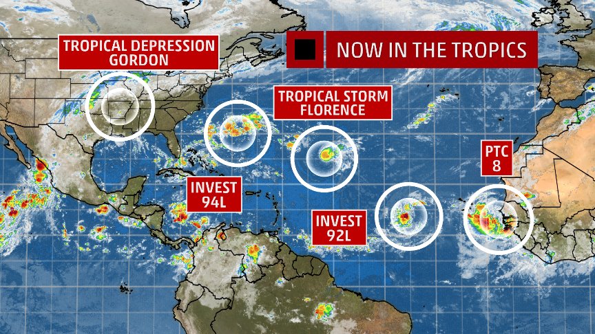
We now have Invest 94L, we'll have to see what impacts, if any, this could have on the track in future runs

Sanchize06- Senior Enthusiast

- Posts : 1041
Reputation : 21
Join date : 2013-02-05
Location : Union Beach, NJ
 Re: FLORENCE: East Coast Threat or Does She Sleep With the Fishes?
So far on today's Guidance the ridge seems to be getting stronger. There are three areas of well below normal Heights which are contributing to this. one off the West Coast 1 in extreme Northern Canada towards Greenland and another one in the central Atlantic which has been getting stronger on modeling and closes off for several days. With Florence now a tropical storm and expected to be so for the next three days she really has nowhere to go but west or south of West as she will be steered by the southern periphery of the ridge and then when she really intensifies the ridge is so strong that she will not be able to penetrate it and turn north just my two cents. Still a long ways to go with this one

algae888- Advanced Forecaster

- Posts : 5311
Reputation : 46
Join date : 2013-02-05
Age : 62
Location : mt. vernon, new york
 Re: FLORENCE: East Coast Threat or Does She Sleep With the Fishes?
Sanchize06 wrote:We now have Invest 94L, we'll have to see what impacts, if any, this could have on the track in future runs
Preliminarily any sense of what developing tropical activity ahead of Florence could do? Slow her down? Cool the waters?

Zhukov1945- Posts : 138
Reputation : 8
Join date : 2018-03-21
Location : Clinton Township NJ
 Re: FLORENCE: East Coast Threat or Does She Sleep With the Fishes?
Bernie Rayno just said the threat area is Cape Hat to Cape Cod, 50/50 anywhere in between.

SoulSingMG- Senior Enthusiast

- Posts : 2853
Reputation : 74
Join date : 2013-12-11
Location : Long Island City, NY
 Re: FLORENCE: East Coast Threat or Does She Sleep With the Fishes?
Zhukov1945 wrote:Sanchize06 wrote:We now have Invest 94L, we'll have to see what impacts, if any, this could have on the track in future runs
Preliminary any sense of what developing tropical activity ahead of Florence could do? Slow her down? Cool the waters?
Slow her down yes and try to weaken the ridge and allow her to travel a bit more North and then it recover cause teh ridge is being pumped by the PAC and jet streak overhead and the warm anomalous water of teh Hotlantic NATL that is. To me this isnt good cause it wold move her more north and when teh ridge recovers she will be forced to go under it and come west. Where west is anyones guess but if yuo factor that it is not seeing 94L on the model runs at this time then it could be 5 degree more maybe 10 all depending which woudl be devastation for the shores of DELMARVA on North - Tom is going to nail this I hate to say it - this guy has a tremendous track record for these set ups and in general (AKA Isotherm).
ICON is scary scenerio - this maybe the 1903 Hcane all over again, an anomalous pattern then and again now with a CV storm.
_________________
Mugs
AKA:King: Snow Weenie
Self Proclaimed
WINTER 2014-15 : 55.12" +.02 for 6 coatings (avg. 35")
WINTER 2015-16 Total - 29.8" (Avg 35")
WINTER 2016-17 : 39.5" so far

amugs- Advanced Forecaster - Mod

- Posts : 15095
Reputation : 213
Join date : 2013-01-07
Age : 54
Location : Hillsdale,NJ
 Re: FLORENCE: East Coast Threat or Does She Sleep With the Fishes?
Models today like the Carolina's. Some even into GA/SC. Goes to show how strong that ridge is to the north.
_________________
_______________________________________________________________________________________________________
CLICK HERE to view NJ Strong Snowstorm Classifications
 Re: FLORENCE: East Coast Threat or Does She Sleep With the Fishes?
Okay, we have to watch out for teh end of the month - the one behind Florence why?
Big Boy planets at play and Full moon.
Tropical Atlantic is serving up a fair amount of storms.
94L if it gets stronger which it could as it hits more conducive waters for development and lower shear could change the fears of an impact on the EC cause he could create a path that would weaken teh ridge and if strong enough disrupt the jet and placement of the players - to what affect again dont know but time will tell. This maybe the saving grace for the EC IF it gets stronger and slices through the Robust ridge before it closes things off.
_________________
Mugs
AKA:King: Snow Weenie
Self Proclaimed
WINTER 2014-15 : 55.12" +.02 for 6 coatings (avg. 35")
WINTER 2015-16 Total - 29.8" (Avg 35")
WINTER 2016-17 : 39.5" so far

amugs- Advanced Forecaster - Mod

- Posts : 15095
Reputation : 213
Join date : 2013-01-07
Age : 54
Location : Hillsdale,NJ
Page 1 of 20 • 1, 2, 3 ... 10 ... 20 
Page 1 of 20
Permissions in this forum:
You cannot reply to topics in this forum|
|
|

 Home
Home