
 Search
Long Range Thread 17.0
Page 7 of 41 •  1 ... 6, 7, 8 ... 24 ... 41
 ![]()
Re: Long Range Thread 17.0
![]() by Frank_Wx Thu Nov 01, 2018 6:30 pm
by Frank_Wx Thu Nov 01, 2018 6:30 pm
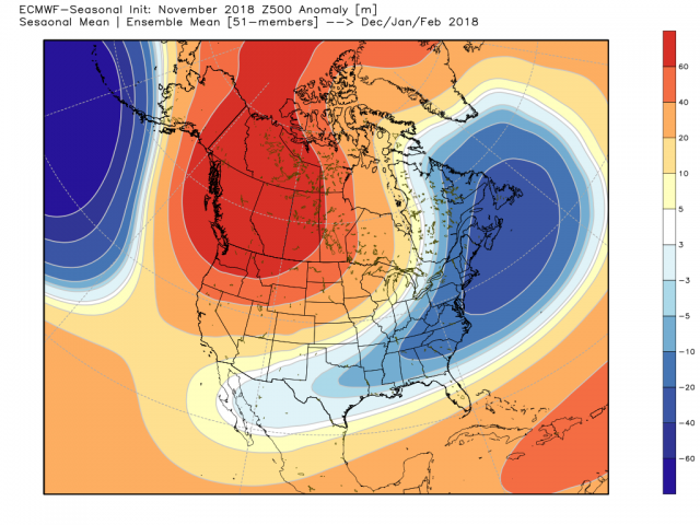
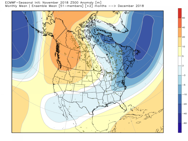
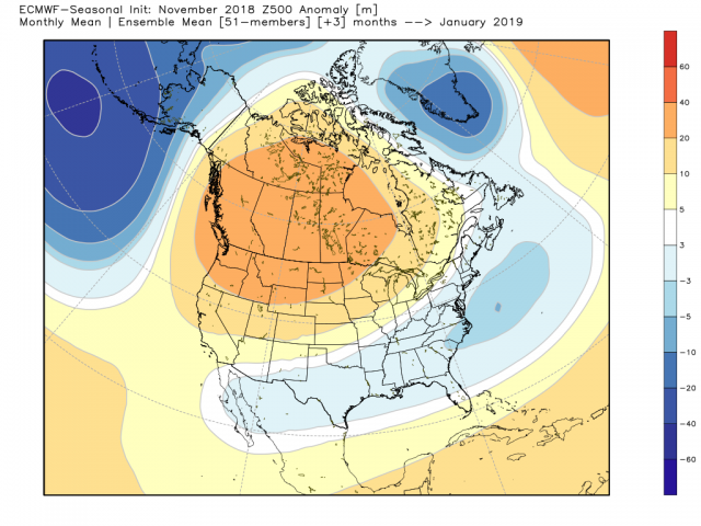
The Stratosphere warming is a huge deal. If we indeed see a full on sudden stratospheric warming event, and the Tropospheric PV is displaced to southern Canada prompting a -AO, then December could potentially be our stormiest month of the winter. But that would mean January could end up being a pretty dramatic thaw, but that's too early of a presumption to make. Right now, focus should be on November and December and so far I like what I see from Thanksgiving through all of December.
An east-based -NAO coupled with a -EPO in mid-November could set the stage for cold and snow for our area the week of the 18th.
GEFS

EPS

NAO blocks are difficult to come by and are often over-played on models in the long range. But with how the MJO is playing out and the warming taking place in the mid-latitudes of the Strat it has merit.
Frank_Wx- Godzilla Seeker

- Posts : 21305
Join date : 2013-01-05 -

Re: Long Range Thread 17.0
![]() by algae888 Sun Nov 04, 2018 2:00 pm
by algae888 Sun Nov 04, 2018 2:00 pm
algae888- Advanced Forecaster

- Posts : 5311
Join date : 2013-02-05
Re: Long Range Thread 17.0
![]() by algae888 Sun Nov 04, 2018 2:03 pm
by algae888 Sun Nov 04, 2018 2:03 pm

algae888- Advanced Forecaster
- Posts : 5311
Reputation : 46
Join date : 2013-02-05
Age : 61
Location : mt. vernon, new york
Re: Long Range Thread 17.0
![]() by amugs Sun Nov 04, 2018 4:15 pm
by amugs Sun Nov 04, 2018 4:15 pm
Courtesy of 33&rain


EPS for the possible snow that may correspond to this arctic air

_________________
Mugs
AKA:King: Snow Weenie
Self Proclaimed
WINTER 2014-15 : 55.12" +.02 for 6 coatings (avg. 35")
WINTER 2015-16 Total - 29.8" (Avg 35")
WINTER 2016-17 : 39.5" so far

amugs- Advanced Forecaster - Mod

- Posts : 15093
Reputation : 213
Join date : 2013-01-07
Age : 54
Location : Hillsdale,NJ
Re: Long Range Thread 17.0
![]() by algae888 Sun Nov 04, 2018 4:45 pm
by algae888 Sun Nov 04, 2018 4:45 pm
algae888- Advanced Forecaster
- Posts : 5311
Reputation : 46
Join date : 2013-02-05
Age : 61
Location : mt. vernon, new york
Re: Long Range Thread 17.0
![]() by amugs Sun Nov 04, 2018 4:50 pm
by amugs Sun Nov 04, 2018 4:50 pm
Current Stretch: 17 days
2018 total: 183 days (60%) = seismic activity and down the road weather affects - HL blocking, more cloudy days etc.
2017 total: 104 days (28%)
2016 total: 32 days (9%)
2015 total: 0 days (0%)
2014 total: 1 day (<1%)
2013 total: 0 days (0%)
2012 total: 0 days (0%)
2011 total: 2 days (<1%)
2010 total: 51 days (14%)
2009 total: 260 days (71%)
2008 total: 268 days (73%)
2007 total: 152 days (42%)
2006 total: 70 days (19%)
Updated 04 Nov 2018
_________________
Mugs
AKA:King: Snow Weenie
Self Proclaimed
WINTER 2014-15 : 55.12" +.02 for 6 coatings (avg. 35")
WINTER 2015-16 Total - 29.8" (Avg 35")
WINTER 2016-17 : 39.5" so far
amugs- Advanced Forecaster - Mod
- Posts : 15093
Reputation : 213
Join date : 2013-01-07
Age : 54
Location : Hillsdale,NJ
Re: Long Range Thread 17.0
![]() by amugs Sun Nov 04, 2018 4:52 pm
by amugs Sun Nov 04, 2018 4:52 pm
algae888 wrote:Yes mugs eps agree with op. The EPS mean snowfall for the next 10 days is one to three in area-wide. A few big hitters in there as we well. have an active Southern stream with this artic air just need the timing to be right as climo is really against us at this time of year
Oh yes along the coastal plain issues but inland not as big


_________________
Mugs
AKA:King: Snow Weenie
Self Proclaimed
WINTER 2014-15 : 55.12" +.02 for 6 coatings (avg. 35")
WINTER 2015-16 Total - 29.8" (Avg 35")
WINTER 2016-17 : 39.5" so far
amugs- Advanced Forecaster - Mod
- Posts : 15093
Reputation : 213
Join date : 2013-01-07
Age : 54
Location : Hillsdale,NJ
Re: Long Range Thread 17.0
![]() by dkodgis Sun Nov 04, 2018 6:54 pm
by dkodgis Sun Nov 04, 2018 6:54 pm

dkodgis- Senior Enthusiast

- Posts : 2493
Reputation : 98
Join date : 2013-12-29
Re: Long Range Thread 17.0
![]() by algae888 Mon Nov 05, 2018 4:10 am
by algae888 Mon Nov 05, 2018 4:10 am
algae888- Advanced Forecaster
- Posts : 5311
Reputation : 46
Join date : 2013-02-05
Age : 61
Location : mt. vernon, new york
algae888- Advanced Forecaster
- Posts : 5311
Reputation : 46
Join date : 2013-02-05
Age : 61
Location : mt. vernon, new york
Re: Long Range Thread 17.0
![]() by amugs Mon Nov 05, 2018 10:19 am
by amugs Mon Nov 05, 2018 10:19 am
FROM THE BELL
SST - POSITIVE PDO, AMO PLUS MODOKI TYPE NINO
MEAN MOMMA MIA BRING ME THIS
DECEMBER TO REMEMBER ??? HIS SAYS POSSIBLY
JANUARY IS FINE - BACKS OFF BUT FINE
FEBRUARY ROCKS
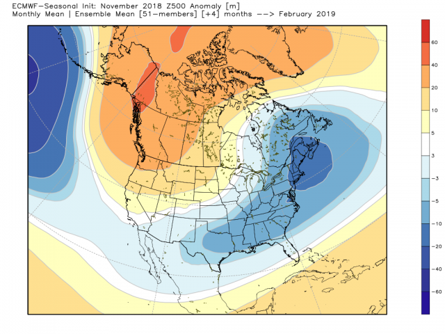
1963 DECEMBER INCOMING? THIS WOULD BE TREMENDOUS!!!
_________________
Mugs
AKA:King: Snow Weenie
Self Proclaimed
WINTER 2014-15 : 55.12" +.02 for 6 coatings (avg. 35")
WINTER 2015-16 Total - 29.8" (Avg 35")
WINTER 2016-17 : 39.5" so far
amugs- Advanced Forecaster - Mod
- Posts : 15093
Reputation : 213
Join date : 2013-01-07
Age : 54
Location : Hillsdale,NJ
Re: Long Range Thread 17.0
![]() by docstox12 Mon Nov 05, 2018 10:27 am
by docstox12 Mon Nov 05, 2018 10:27 am

docstox12- Wx Statistician Guru

- Posts : 8502
Reputation : 222
Join date : 2013-01-07
Age : 73
Location : Monroe NY
Re: Long Range Thread 17.0
![]() by amugs Mon Nov 05, 2018 10:30 am
by amugs Mon Nov 05, 2018 10:30 am
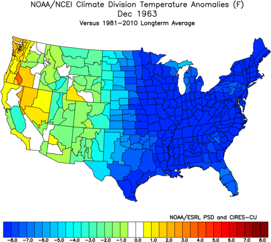
docstox12 wrote:Mugsy, love that Dec 1963 map.We had 8 or 9 inches of snow in Fort Lee the day before Christmas Eve and the big snowstorm in February 1964.Hope this analog proves out for this season.I remember that as a cold winter.
Me too - lots of good signs so far.
_________________
Mugs
AKA:King: Snow Weenie
Self Proclaimed
WINTER 2014-15 : 55.12" +.02 for 6 coatings (avg. 35")
WINTER 2015-16 Total - 29.8" (Avg 35")
WINTER 2016-17 : 39.5" so far
amugs- Advanced Forecaster - Mod
- Posts : 15093
Reputation : 213
Join date : 2013-01-07
Age : 54
Location : Hillsdale,NJ
Re: Long Range Thread 17.0
![]() by amugs Mon Nov 05, 2018 10:48 am
by amugs Mon Nov 05, 2018 10:48 am

1.2 drop you biag!!

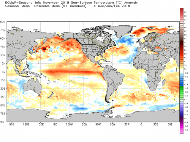
This i a nice look to my amatuer eye - I love teh colder waters west of Aussie land and teh warmer near the dateline to about 150- this will promote that Rossby wave to develop in sector 8, 1,2 phases of this region. Also that orangey blob in the GOA (Gulf of Alaska) REMINISCENT OF 13-14, 14-15

SOLAR COOPERATING bigly TOO!!
BOOOYAHHHH
Spotless Days
Current Stretch: 18 days
2018 total: 184 days (60%)
2017 total: 104 days (28%)
_________________
Mugs
AKA:King: Snow Weenie
Self Proclaimed
WINTER 2014-15 : 55.12" +.02 for 6 coatings (avg. 35")
WINTER 2015-16 Total - 29.8" (Avg 35")
WINTER 2016-17 : 39.5" so far
amugs- Advanced Forecaster - Mod
- Posts : 15093
Reputation : 213
Join date : 2013-01-07
Age : 54
Location : Hillsdale,NJ
Re: Long Range Thread 17.0
![]() by docstox12 Mon Nov 05, 2018 11:49 am
by docstox12 Mon Nov 05, 2018 11:49 am

Mugsy...Godzilla taking a leak! HILARIOUS!
docstox12- Wx Statistician Guru
- Posts : 8502
Reputation : 222
Join date : 2013-01-07
Age : 73
Location : Monroe NY
Re: Long Range Thread 17.0
![]() by amugs Mon Nov 05, 2018 12:32 pm
by amugs Mon Nov 05, 2018 12:32 pm
This from a pro met Webberweather - GREAT SIGN!!
The westerly QBO has descended below 30 mb but the easterly regime remains stedfast in the lower stratosphere. As mentioned in an earlier post here, we're in the "goldilocks zone" so to speak for a sudden stratospheric warming event this year in QBO phase space, with the QBO transitioning from easterly to westerly. It should make sense to some why SSWEs are most favored during the easterly to westerly hand-off because this usually means the descending easterlies are closest to the tropical tropopause, providing the largest impact to shear and static stability there, implicating tropical convection and ultimately leading to the most pronounced acceleration of the Brewer Dobson Circulation that leads to the most advanced concomitant warming of the polar stratosphere. The fact we're encroaching on solar minimum and have an El Nino to enhance the standing planetary waves in the western hemisphere and Pacific helps our case for a SSWE this year
_________________
Mugs
AKA:King: Snow Weenie
Self Proclaimed
WINTER 2014-15 : 55.12" +.02 for 6 coatings (avg. 35")
WINTER 2015-16 Total - 29.8" (Avg 35")
WINTER 2016-17 : 39.5" so far
amugs- Advanced Forecaster - Mod
- Posts : 15093
Reputation : 213
Join date : 2013-01-07
Age : 54
Location : Hillsdale,NJ
Re: Long Range Thread 17.0
![]() by amugs Tue Nov 06, 2018 1:57 pm
by amugs Tue Nov 06, 2018 1:57 pm
_________________
Mugs
AKA:King: Snow Weenie
Self Proclaimed
WINTER 2014-15 : 55.12" +.02 for 6 coatings (avg. 35")
WINTER 2015-16 Total - 29.8" (Avg 35")
WINTER 2016-17 : 39.5" so far
amugs- Advanced Forecaster - Mod
- Posts : 15093
Reputation : 213
Join date : 2013-01-07
Age : 54
Location : Hillsdale,NJ
Re: Long Range Thread 17.0
![]() by amugs Tue Nov 06, 2018 2:15 pm
by amugs Tue Nov 06, 2018 2:15 pm
Could be a December to remember peeps.
It may not start out that way but by the early teens we should see that evolving back to a gripping winter pattern. Heck it could change earlier but not much later from all indicies I am seeing.
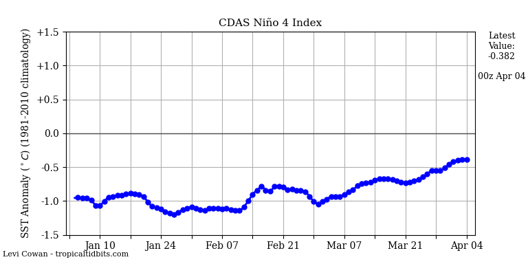
1.2 is listening to me BIGLY! MODOKI NINO shaping up
3.4 and 4 hold steady
From 33&rain showing the Kelvin Wave

You cans ee the deep blue is teh wave
Now this will be good as it will enhance the ability for a SSW event as being forecasted for a disruption in Mid Dec of the Polar Vortex.
The EAMT and Pac Jet Extension will aid in this as well so we'll take a 10 -12 day moderation and then allow this heat to jet set poleward and allow the aiding of a SSW as I see it.
The BOM MJO forecast is based on this but we'll see

EURO Kills it before we get to the warmer phases

SOLAR stays NILL - 19 in a row
Spotless Days
Current Stretch: 19 days
2018 total: 185 days (60%)
Okay so it will get cold this weekend and then the bottom falls out next week.
_________________
Mugs
AKA:King: Snow Weenie
Self Proclaimed
WINTER 2014-15 : 55.12" +.02 for 6 coatings (avg. 35")
WINTER 2015-16 Total - 29.8" (Avg 35")
WINTER 2016-17 : 39.5" so far
amugs- Advanced Forecaster - Mod
- Posts : 15093
Reputation : 213
Join date : 2013-01-07
Age : 54
Location : Hillsdale,NJ
Re: Long Range Thread 17.0
![]() by sroc4 Tue Nov 06, 2018 3:42 pm
by sroc4 Tue Nov 06, 2018 3:42 pm
sroc4 wrote:MJO when propagating with amplitude has been a dominant driver so far this fall, and looks to cont. Given the SSTA configuration along the entire Pac equatorial region, the MJO gaining amplitude and propagation primarily through phases 8-1-2 then back towards the center will likely be a common theme going forward as this trend has already started and looks to continue with this next wave pulse.....
….It looks like we are back into a new wave propagation with a similar pattern; which given the SSTA configuration should cont well into the winter. Below are the current MJO forecasts for the next two weeks. Both the Eruo and GEFS have a forecast and a "corrected" forecast. I will post the "corrected" forecast as the second image. Notice the GEFS forecast takes the MJO well into phases 3-4 towards 5 whereas the corrected forecast does not. I fully expect the SSTA configuration to prevent this wave from entering phases 3-5 with any amplitude.
…...As Mugsy posted above I expect modeling to go towards a cooler soln overall as we head into the second week of Nov with some warmth, relative to avgs, ahead of phase 2. BUT I don't think we torch by any stretch of the imagination.


Lets revisit this convo. Here are just the corrected MJO forecasts from prev vs today. As you can see we are correcting with less amplitude into the Phases 3-5 as expected.


GEFS


EURO


And if you look at the direction the end of the forecast is headed you'll notice back towards 8.
Mugs it will be interesting to see if that week 2 200mb VP map you posted from the Ventrice site holds up. If you compare it to the latest GFS 200mb VP forecast it has a large area of subsidence/convergence over the same region the Ventrice maps has divergence by Nov 21st


Just like in prev years when weve seen a cold spell show up in the LR only to see it evolve into not nearly as cold as it looked I can see how this "warm spell" or period of moderation everyone is talking about after the cold shot next weekend into next week will end up not nearly as warm if not cool when we get closer. Well see.
_________________
"In weather and in life, there's no winning and losing; there's only winning and learning."
WINTER 2012/2013 TOTALS 43.65"WINTER 2017/2018 TOTALS 62.85" WINTER 2022/2023 TOTALS 4.9"
WINTER 2013/2014 TOTALS 64.85"WINTER 2018/2019 TOTALS 14.25" WINTER 2023/2024 TOTALS 13.1"
WINTER 2014/2015 TOTALS 71.20"WINTER 2019/2020 TOTALS 6.35"
WINTER 2015/2016 TOTALS 35.00"WINTER 2020/2021 TOTALS 37.75"
WINTER 2016/2017 TOTALS 42.25"WINTER 2021/2022 TOTALS 31.65"

sroc4- Admin
- Posts : 8331
Reputation : 301
Join date : 2013-01-07
Location : Wading River, LI
Re: Long Range Thread 17.0
![]() by mwilli5783 Tue Nov 06, 2018 4:31 pm
by mwilli5783 Tue Nov 06, 2018 4:31 pm
mwilli5783- Posts : 146
Reputation : 9
Join date : 2013-01-23
Age : 69
Location : hempstead n.y
Re: Long Range Thread 17.0
![]() by frank 638 Tue Nov 06, 2018 5:03 pm
by frank 638 Tue Nov 06, 2018 5:03 pm
frank 638- Senior Enthusiast
- Posts : 2824
Reputation : 37
Join date : 2016-01-01
Age : 40
Location : bronx ny
Re: Long Range Thread 17.0
![]() by amugs Tue Nov 06, 2018 7:47 pm
by amugs Tue Nov 06, 2018 7:47 pm
I concur on the moderation period and the next few days of these charts will help tell, one thing is for sure the cold waves incoming are going to be very cold for this time of year.
I hope the Euro MJO forecast comes to fruition as it kills the wave in the COD and then remedies it in phase 8. That seems to be the "pattern" as we move forward.
I have read the EAMT is going to pump the PAC JET extension and bring a flat zonal flow. This doesn't scream torch but more normalish air and hopefully the WAR doesnt flex it's nuscle. Temp in the NA region and off the coast have cooled considerably so we shall see.
Great discussion and maps here peeps.
Tell Lee Goldberg whom I like that we were in this a few days ago chappy, LOL!!
_________________
Mugs
AKA:King: Snow Weenie
Self Proclaimed
WINTER 2014-15 : 55.12" +.02 for 6 coatings (avg. 35")
WINTER 2015-16 Total - 29.8" (Avg 35")
WINTER 2016-17 : 39.5" so far
amugs- Advanced Forecaster - Mod
- Posts : 15093
Reputation : 213
Join date : 2013-01-07
Age : 54
Location : Hillsdale,NJ
Re: Long Range Thread 17.0
![]() by amugs Tue Nov 06, 2018 7:50 pm
by amugs Tue Nov 06, 2018 7:50 pm
On my phone so when I get to my computer I'll upload maps.
_________________
Mugs
AKA:King: Snow Weenie
Self Proclaimed
WINTER 2014-15 : 55.12" +.02 for 6 coatings (avg. 35")
WINTER 2015-16 Total - 29.8" (Avg 35")
WINTER 2016-17 : 39.5" so far
amugs- Advanced Forecaster - Mod
- Posts : 15093
Reputation : 213
Join date : 2013-01-07
Age : 54
Location : Hillsdale,NJ
Re: Long Range Thread 17.0
![]() by amugs Tue Nov 06, 2018 11:34 pm
by amugs Tue Nov 06, 2018 11:34 pm

_________________
Mugs
AKA:King: Snow Weenie
Self Proclaimed
WINTER 2014-15 : 55.12" +.02 for 6 coatings (avg. 35")
WINTER 2015-16 Total - 29.8" (Avg 35")
WINTER 2016-17 : 39.5" so far
amugs- Advanced Forecaster - Mod
- Posts : 15093
Reputation : 213
Join date : 2013-01-07
Age : 54
Location : Hillsdale,NJ
Re: Long Range Thread 17.0
![]() by amugs Tue Nov 06, 2018 11:35 pm
by amugs Tue Nov 06, 2018 11:35 pm

_________________
Mugs
AKA:King: Snow Weenie
Self Proclaimed
WINTER 2014-15 : 55.12" +.02 for 6 coatings (avg. 35")
WINTER 2015-16 Total - 29.8" (Avg 35")
WINTER 2016-17 : 39.5" so far
amugs- Advanced Forecaster - Mod
- Posts : 15093
Reputation : 213
Join date : 2013-01-07
Age : 54
Location : Hillsdale,NJ
Re: Long Range Thread 17.0
![]() by algae888 Wed Nov 07, 2018 6:51 am
by algae888 Wed Nov 07, 2018 6:51 am
algae888- Advanced Forecaster
- Posts : 5311
Reputation : 46
Join date : 2013-02-05
Age : 61
Location : mt. vernon, new york
Re: Long Range Thread 17.0
![]() by algae888 Wed Nov 07, 2018 11:35 am
by algae888 Wed Nov 07, 2018 11:35 am
algae888- Advanced Forecaster
- Posts : 5311
Reputation : 46
Join date : 2013-02-05
Age : 61
Location : mt. vernon, new york
Page 7 of 41 • 1 ... 6, 7, 8 ... 24 ... 41 ![]()
|
|
|