Long Range Thread 17.0
+40
Radz
lglickman1
Wheezer
aiannone
heehaw453
SENJsnowman
Scullybutcher
jake732
Sanchize06
larryrock72
bobjohnsonforthehall
SnowForest
hyde345
SoulSingMG
weatherwatchermom
MattyICE
GreyBeard
Smittyaj623
HectorO
Vinnydula
Nyi1058
jmanley32
CPcantmeasuresnow
Dunnzoo
algae888
skinsfan1177
Snow88
Quietace
rb924119
dkodgis
sroc4
docstox12
Grselig
amugs
Math23x7
billg315
nutleyblizzard
frank 638
mwilli5783
Frank_Wx
44 posters
Page 1 of 41
Page 1 of 41 • 1, 2, 3 ... 21 ... 41 
 Long Range Thread 17.0
We're approaching mid-September. Dark is trying to overtake light. Coolness is trying to overtake warmth. Retail stores are setting up for Christmas and every flavor of food is sold in pumpkin spice. The truth cannot be denied.
Winter is coming.
And with that dramatic start to the 17th edition of NJ Strong's Long Range thread let's start talking about, well, the long range! Beginning next week I am going to make several posts about Pacific and Atlantic sea surface temps (AMO, PDO, ENSO), the QBO (Stratosphere), and begin looking into possible Analogs. My days of crafting winter outlooks are over but that does not mean I find this stuff any less fascinating. And honestly, there are a ton of smart people on this site I want to discuss these things with!
I will say the PAC/ATL SSTA's tell quite a story right now.
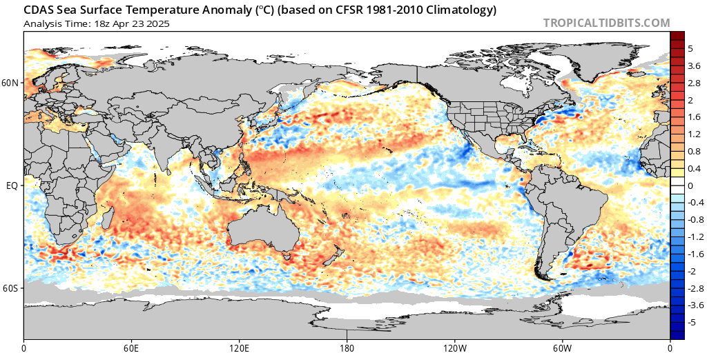
Since 1995, the AMO, a measure of SST's in the Atlantic, has been in a warm phase. There's signs we may be coming out of the warm phase and transitioning into a cold one. The fulleffects will NOT be felt on the pattern for this winter, but it's still noteworthy in the sense it could affect the winters to come. Meanwhile, warm SST's still dominate the northern PAC. This feedback into the atmosphere will surely cause ridging to develop in that part of the world at many points this winter.
To be honest I am kind of pumped. I like what I see for prospects of colder than normal weather. Especially early on (December to remember anyone?).
We'll talk about it all here.
Hasta pasta!
Winter is coming.
And with that dramatic start to the 17th edition of NJ Strong's Long Range thread let's start talking about, well, the long range! Beginning next week I am going to make several posts about Pacific and Atlantic sea surface temps (AMO, PDO, ENSO), the QBO (Stratosphere), and begin looking into possible Analogs. My days of crafting winter outlooks are over but that does not mean I find this stuff any less fascinating. And honestly, there are a ton of smart people on this site I want to discuss these things with!
I will say the PAC/ATL SSTA's tell quite a story right now.

Since 1995, the AMO, a measure of SST's in the Atlantic, has been in a warm phase. There's signs we may be coming out of the warm phase and transitioning into a cold one. The fulleffects will NOT be felt on the pattern for this winter, but it's still noteworthy in the sense it could affect the winters to come. Meanwhile, warm SST's still dominate the northern PAC. This feedback into the atmosphere will surely cause ridging to develop in that part of the world at many points this winter.
To be honest I am kind of pumped. I like what I see for prospects of colder than normal weather. Especially early on (December to remember anyone?).
We'll talk about it all here.
Hasta pasta!
_________________
_______________________________________________________________________________________________________
CLICK HERE to view NJ Strong Snowstorm Classifications
 Re: Long Range Thread 17.0
farmer's almannac said the northeast gets colder temps,above avg snowfall dec and on..don't like winter(born n the summer)but i do likewatching the snow fall and u guys updates on godzilla,mega and so on..i'm pumped 4 godzilla but i need more ice melt..lol
mwilli5783- Posts : 146
Reputation : 9
Join date : 2013-01-23
Age : 69
Location : hempstead n.y
 Re: Long Range Thread 17.0
Hey Frank I hope you had a great summer .I look forward for winter and I hope we all get a cold and snowy winter
frank 638- Senior Enthusiast

- Posts : 2843
Reputation : 37
Join date : 2016-01-01
Age : 40
Location : bronx ny
 Re: Long Range Thread 17.0
My early first call: Below normal temps and 50+ inches of snow area wide. My reasoning? A weak Modoki El Nino, +PDO, -QBO and we are entering the peak of the solar minimum.

nutleyblizzard- Senior Enthusiast

- Posts : 1954
Reputation : 41
Join date : 2014-01-30
Age : 58
Location : Nutley, new jersey
 Re: Long Range Thread 17.0
GFS has some patches of snow in western/central NY state around Sept 26. Might not hold, but the mere fact snow is showing up on the models only a couple hundred miles from here in two weeks is a good sign that winter, is indeed, coming.

billg315- Advanced Forecaster - Mod

- Posts : 4483
Reputation : 185
Join date : 2015-01-24
Age : 50
Location : Flemington, NJ
 Re: Long Range Thread 17.0
The last White Christmas in NYC: 2009. That drought ends this year. Remember Christmas 2002? Bank on a similar setup happening for Christmas 2018.
Math23x7- Wx Statistician Guru

- Posts : 2379
Reputation : 68
Join date : 2013-01-08
 Re: Long Range Thread 17.0
I concur on may pints but we ain't seen nothing yet on the grand solar minimum my man.nutleyblizzard wrote:My early first call: Below normal temps and 50+ inches of snow area wide. My reasoning? A weak Modoki El Nino, +PDO, -QBO and we are entering the peak of the solar minimum.
_________________
Mugs
AKA:King: Snow Weenie
Self Proclaimed
WINTER 2014-15 : 55.12" +.02 for 6 coatings (avg. 35")
WINTER 2015-16 Total - 29.8" (Avg 35")
WINTER 2016-17 : 39.5" so far

amugs- Advanced Forecaster - Mod

- Posts : 15095
Reputation : 213
Join date : 2013-01-07
Age : 54
Location : Hillsdale,NJ
 Re: Long Range Thread 17.0
Point to remember the HP this summer over SE Canada and NE = cold and bitter cold for our area.
_________________
Mugs
AKA:King: Snow Weenie
Self Proclaimed
WINTER 2014-15 : 55.12" +.02 for 6 coatings (avg. 35")
WINTER 2015-16 Total - 29.8" (Avg 35")
WINTER 2016-17 : 39.5" so far

amugs- Advanced Forecaster - Mod

- Posts : 15095
Reputation : 213
Join date : 2013-01-07
Age : 54
Location : Hillsdale,NJ
 Re: Long Range Thread 17.0
Been a long hot rainy boring summer. Time for winter. Time to skip the autumn and go straight to the main event!
Grselig- Senior Enthusiast

- Posts : 1408
Reputation : 140
Join date : 2013-03-04
Age : 54
Location : Wayne NJ
 Re: Long Range Thread 17.0
I have a good feeling we will see some good cold weather but I am worried about a wicked mean reversion to very dry this winter as a result of this overabundance of rain these past few months.I would hate to see a repeat of the 1976-1977 winter with lots of cold but dry weather.One of those suppression trpe winters around here.Hope I am totally wrong and I get 84 inches like last year, a truly amazing winter up here.

docstox12- Wx Statistician Guru

- Posts : 8530
Reputation : 222
Join date : 2013-01-07
Age : 73
Location : Monroe NY
 Re: Long Range Thread 17.0
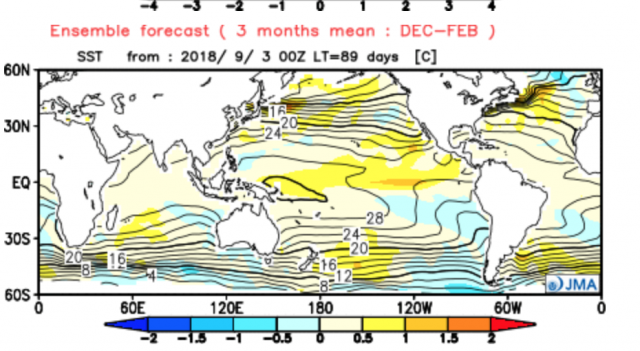
The great Joe Bastardi posted the latest JMA winter forecast. Lots of high latitude blocking and cold over the eastern CONUS
.png)
He also posted the SSTA's. Looks like a Modoki El Nino develops.
.png)
He also posted the SSTA's. Looks like a Modoki El Nino develops.

_________________
_______________________________________________________________________________________________________
CLICK HERE to view NJ Strong Snowstorm Classifications
 Re: Long Range Thread 17.0
Frank_Wx wrote:The great Joe Bastardi posted the latest JMA winter forecast. Lots of high latitude blocking and cold over the eastern CONUS
He also posted the SSTA's. Looks like a Modoki El Nino develops.
You beat me to it kid!! This model just did a great job with our past winter and this hurricane or tropical cyclone uptick in the atlantic.
I have GWO and David Dilley's forecast - just have to upload it - pdf file it too large to so I need to figure this out
_________________
Mugs
AKA:King: Snow Weenie
Self Proclaimed
WINTER 2014-15 : 55.12" +.02 for 6 coatings (avg. 35")
WINTER 2015-16 Total - 29.8" (Avg 35")
WINTER 2016-17 : 39.5" so far

amugs- Advanced Forecaster - Mod

- Posts : 15095
Reputation : 213
Join date : 2013-01-07
Age : 54
Location : Hillsdale,NJ
 Re: Long Range Thread 17.0
I haven't had the chance to look at the drivers, but the long range GFS Ensembles are showing a deep Aleutian trough, ridging over the west and trough on the east to begin October. Not sure how real this is yet but I recall Scott posting in another thread the MJO becoming active which could jumpstart the pattern. Not to mention SSTAs in the north PAC are running above normal.


_________________
_______________________________________________________________________________________________________
CLICK HERE to view NJ Strong Snowstorm Classifications
 Re: Long Range Thread 17.0
Frank_Wx wrote:I haven't had the chance to look at the drivers, but the long range GFS Ensembles are showing a deep Aleutian trough, ridging over the west and trough on the east to begin October. Not sure how real this is yet but I recall Scott posting in another thread the MJO becoming active which could jumpstart the pattern. Not to mention SSTAs in the north PAC are running above normal.
Oh man Frank. Give me this look In Jan and I would sign today.
_________________
"In weather and in life, there's no winning and losing; there's only winning and learning."
WINTER 2012/2013 TOTALS 43.65"WINTER 2017/2018 TOTALS 62.85" WINTER 2022/2023 TOTALS 4.9"
WINTER 2013/2014 TOTALS 64.85"WINTER 2018/2019 TOTALS 14.25" WINTER 2023/2024 TOTALS 13.1"
WINTER 2014/2015 TOTALS 71.20"WINTER 2019/2020 TOTALS 6.35"
WINTER 2015/2016 TOTALS 35.00"WINTER 2020/2021 TOTALS 37.75"
WINTER 2016/2017 TOTALS 42.25"WINTER 2021/2022 TOTALS 31.65"

sroc4- Admin

- Posts : 8354
Reputation : 302
Join date : 2013-01-07
Location : Wading River, LI
 Re: Long Range Thread 17.0
I hope you all have a twitter to see this
https://twitter.com/nj_strong_wx/status/1040705034252677120?s=19
https://twitter.com/nj_strong_wx/status/1040705034252677120?s=19
_________________
_______________________________________________________________________________________________________
CLICK HERE to view NJ Strong Snowstorm Classifications
 Re: Long Range Thread 17.0
That is great news Frank thank you for ur post I hope we all have a cold and snowy winter
frank 638- Senior Enthusiast

- Posts : 2843
Reputation : 37
Join date : 2016-01-01
Age : 40
Location : bronx ny
 Re: Long Range Thread 17.0
The GFS and ECM continue to show an MJO entering phases 8 and 1 at the end of this month into October. Both ensemble suites from these models are in fair agreement medium to long term.
Week of September 24th:
00z EPS:


06z GEFS:

The final week of September will run above normal. The next two weeks the PNA will be negative. Low heights over the west typically corresponds to higher heights over the east. Then as mentioned the MJO becomes active. It will take some time for the affects to show on the models and translate to our surface, but it's possible the -PNA will be replaced by a +PNA with higher heights extending into the EPO domain, or Alaska. This will help draw seasonable or cooler than normal weather into the eastern U.S. between October 3rd and 7th (+/- 2 days).
Week of September 24th:
00z EPS:


06z GEFS:

The final week of September will run above normal. The next two weeks the PNA will be negative. Low heights over the west typically corresponds to higher heights over the east. Then as mentioned the MJO becomes active. It will take some time for the affects to show on the models and translate to our surface, but it's possible the -PNA will be replaced by a +PNA with higher heights extending into the EPO domain, or Alaska. This will help draw seasonable or cooler than normal weather into the eastern U.S. between October 3rd and 7th (+/- 2 days).
_________________
_______________________________________________________________________________________________________
CLICK HERE to view NJ Strong Snowstorm Classifications
 Re: Long Range Thread 17.0
The last couple of frames from the 00z EPS last night began to look like the GEFS images above. Slowly coming to agreement that October could open with normal to below normal temps. At this moment it looks to be transient, maybe 2-3 days, but lets see if the MJO can provide us with something more sustainable.
_________________
_______________________________________________________________________________________________________
CLICK HERE to view NJ Strong Snowstorm Classifications
 Re: Long Range Thread 17.0
Frank do you think Oct will turn out to be like last year or will it be below normal for temps wise
frank 638- Senior Enthusiast

- Posts : 2843
Reputation : 37
Join date : 2016-01-01
Age : 40
Location : bronx ny
 Re: Long Range Thread 17.0
frank 638 wrote:Frank do you think Oct will turn out to be like last year or will it be below normal for temps wise
My definition of "normal" is -0.5 to +0.5
Below normal is less than -0.5
Above normal is greater than +0.5
I think October will finish above normal. Even though it looks to start out cool the days we get warm could be very warm. Not sure if the air will be cold enough to off-set those warm days just yet.
This can change though. If the MJO does get active and the Stratosphere continues to warm...early high latitude blocking may develop which would ensure a below normal October. I'm not seeing that quite yet, however.
_________________
_______________________________________________________________________________________________________
CLICK HERE to view NJ Strong Snowstorm Classifications
 Re: Long Range Thread 17.0
Last edited by sroc4 on Wed Nov 28, 2018 7:39 am; edited 2 times in total
_________________
"In weather and in life, there's no winning and losing; there's only winning and learning."
WINTER 2012/2013 TOTALS 43.65"WINTER 2017/2018 TOTALS 62.85" WINTER 2022/2023 TOTALS 4.9"
WINTER 2013/2014 TOTALS 64.85"WINTER 2018/2019 TOTALS 14.25" WINTER 2023/2024 TOTALS 13.1"
WINTER 2014/2015 TOTALS 71.20"WINTER 2019/2020 TOTALS 6.35"
WINTER 2015/2016 TOTALS 35.00"WINTER 2020/2021 TOTALS 37.75"
WINTER 2016/2017 TOTALS 42.25"WINTER 2021/2022 TOTALS 31.65"

sroc4- Admin

- Posts : 8354
Reputation : 302
Join date : 2013-01-07
Location : Wading River, LI
 Re: Long Range Thread 17.0
Piggy-backing off my posts above the models continue to show what would be a blast of fall-like temps into the area late September into early October. The -EPO/+PNA forces a trough over the east.
GEFS September 29th:


GEFS October 3rd


The EPS are in agreement

It will be interesting to see how long the trough will hold over the east. I think the period between September 28th (+/- 2 days) and October 4th (+/- 2 days) will feature below normal temps. How long it lasts remains to be seen. Most likely, this time of year, it is transient.
GEFS September 29th:


GEFS October 3rd


The EPS are in agreement

It will be interesting to see how long the trough will hold over the east. I think the period between September 28th (+/- 2 days) and October 4th (+/- 2 days) will feature below normal temps. How long it lasts remains to be seen. Most likely, this time of year, it is transient.
_________________
_______________________________________________________________________________________________________
CLICK HERE to view NJ Strong Snowstorm Classifications
 Re: Long Range Thread 17.0
Frank_Wx wrote:frank 638 wrote:Frank do you think Oct will turn out to be like last year or will it be below normal for temps wise
My definition of "normal" is -0.5 to +0.5
Below normal is less than -0.5
Above normal is greater than +0.5
I think October will finish above normal. Even though it looks to start out cool the days we get warm could be very warm. Not sure if the air will be cold enough to off-set those warm days just yet.
This can change though. If the MJO does get active and the Stratosphere continues to warm...early high latitude blocking may develop which would ensure a below normal October. I'm not seeing that quite yet, however.
ANd why can it get warm? look at the SST off the coast - very much AN and this will help propagate warmth when the EPO, AO, PNA drivers aren't there in one respect - it allows the WAR to flex its muscle and expand west.

BUT I love that AN pool of water in the Gulf of ALaska and the Aleutians - that may do wonders for a N WPO and EPO couplet as well as help the PNA feedback - can we get that over the top of the arctic? Remains to be seen but tropical forcing (ENSO - Weak Nino) AAM and GWO along with the QBO and low solar are also mechanisms we need to be aware of.
_________________
Mugs
AKA:King: Snow Weenie
Self Proclaimed
WINTER 2014-15 : 55.12" +.02 for 6 coatings (avg. 35")
WINTER 2015-16 Total - 29.8" (Avg 35")
WINTER 2016-17 : 39.5" so far

amugs- Advanced Forecaster - Mod

- Posts : 15095
Reputation : 213
Join date : 2013-01-07
Age : 54
Location : Hillsdale,NJ
 Re: Long Range Thread 17.0
I think I lost my post from before so here goes again. My limited understanding is the Modoki El Nino is a more centered, warmer section of the Pacific and we may get a snowier and colder winter-at least I think this was the setup in those two winters 2013,2014 that Bastardi said would be very cold. Also, if there is high pressure off of Alaska, this encourages the Jetstream to dip and in comes the arctic air. I remember asking Frank about why Red Sox Suck had so much snow that one year and he said there was blocking above Greenland-which I think may be in place this winter. Add Mugs' comments on the solar minimum and get ya popcorn. Al this may thaw CP before long.

dkodgis- Senior Enthusiast

- Posts : 2560
Reputation : 98
Join date : 2013-12-29
Page 1 of 41 • 1, 2, 3 ... 21 ... 41 
Page 1 of 41
Permissions in this forum:
You cannot reply to topics in this forum|
|
|

 Home
Home