December 2018 Observations and Discussions
+27
oldtimer
heehaw453
crippo84
Sanchize06
GreyBeard
CPcantmeasuresnow
SoulSingMG
aiannone
hyde345
mwilli5783
nutleyblizzard
Radz
rb924119
Vinnydula
jmanley32
skinsfan1177
weatherwatchermom
algae888
SENJsnowman
Frank_Wx
sroc4
frank 638
billg315
dkodgis
docstox12
amugs
Dunnzoo
31 posters
Page 1 of 14
Page 1 of 14 • 1, 2, 3 ... 7 ... 14 
 December 2018 Observations and Discussions
Ugh, rain and 46°. Not what I want to see in December.
_________________
Janet
Snowfall winter of 2023-2024 17.5"
Snowfall winter of 2022-2023 6.0"
Snowfall winter of 2021-2022 17.6" 1" sleet 2/25/22
Snowfall winter of 2020-2021 51.1"
Snowfall winter of 2019-2020 8.5"
Snowfall winter of 2018-2019 25.1"
Snowfall winter of 2017-2018 51.9"
Snowfall winter of 2016-2017 45.6"
Snowfall winter of 2015-2016 29.5"
Snowfall winter of 2014-2015 50.55"
Snowfall winter of 2013-2014 66.5"
Dunnzoo- Senior Enthusiast - Mod

- Posts : 4904
Reputation : 68
Join date : 2013-01-11
Age : 62
Location : Westwood, NJ
 Re: December 2018 Observations and Discussions
Happy Met winter everyone!!
_________________
Mugs
AKA:King: Snow Weenie
Self Proclaimed
WINTER 2014-15 : 55.12" +.02 for 6 coatings (avg. 35")
WINTER 2015-16 Total - 29.8" (Avg 35")
WINTER 2016-17 : 39.5" so far

amugs- Advanced Forecaster - Mod

- Posts : 15095
Reputation : 213
Join date : 2013-01-07
Age : 54
Location : Hillsdale,NJ
 Re: December 2018 Observations and Discussions
TY Mugsy! Raw, drizzly, damp today.Nice cold snap coming up to stay in the Christmas spirit!

docstox12- Wx Statistician Guru

- Posts : 8530
Reputation : 222
Join date : 2013-01-07
Age : 73
Location : Monroe NY
 Re: December 2018 Observations and Discussions
¿Dónde está la nieve?

dkodgis- Senior Enthusiast

- Posts : 2560
Reputation : 98
Join date : 2013-12-29
 Re: December 2018 Observations and Discussions
You can feel the cold air filtering in. Day started off almost spring-like, but the winds this afternoon had a cold feel to them. Looks like several days of below normal temps lay ahead. That said, I have seen some snowy Decembers, but now a few days in, looking at the short to medium range guidance, it's not looking like this will be one of them. Unless the last third of the month comes up big for us.

billg315- Advanced Forecaster - Mod

- Posts : 4483
Reputation : 185
Join date : 2015-01-24
Age : 50
Location : Flemington, NJ
 Re: December 2018 Observations and Discussions
The winds did kick up today. 52 here and while the wind came snd went, it was a nice day

dkodgis- Senior Enthusiast

- Posts : 2560
Reputation : 98
Join date : 2013-12-29
 Re: December 2018 Observations and Discussions
Look at the cold in SE CAN - that will make it here come early January. and then again in February


_________________
Mugs
AKA:King: Snow Weenie
Self Proclaimed
WINTER 2014-15 : 55.12" +.02 for 6 coatings (avg. 35")
WINTER 2015-16 Total - 29.8" (Avg 35")
WINTER 2016-17 : 39.5" so far

amugs- Advanced Forecaster - Mod

- Posts : 15095
Reputation : 213
Join date : 2013-01-07
Age : 54
Location : Hillsdale,NJ
 Re: December 2018 Observations and Discussions
Surprise surprise. An ever so light dusting going on right now

dkodgis- Senior Enthusiast

- Posts : 2560
Reputation : 98
Join date : 2013-12-29
 Re: December 2018 Observations and Discussions
And surprise, surprise, there is still a light dusting this am. 

dkodgis- Senior Enthusiast

- Posts : 2560
Reputation : 98
Join date : 2013-12-29
 Re: December 2018 Observations and Discussions
So depressing that we got all this cold air with no snow in sight
frank 638- Senior Enthusiast

- Posts : 2843
Reputation : 37
Join date : 2016-01-01
Age : 40
Location : bronx ny
 Re: December 2018 Observations and Discussions
frank 638 wrote:So depressing that we got all this cold air with no snow in sight
Agree 100% especially when I see NWS forecasting up to 20 inches for the Blue Ridge Mountain area of Virginia.One of the worst things IMO is having a week of snow producing cold air with nothing to show for it.After that massive amount of rain in the spring and summer I'm hoping that does not result in a cold and dry winter for us with all the snowstorms sliding south like the Snowmageddon Winter.As the crawl above states, it's cold and dry here.

docstox12- Wx Statistician Guru

- Posts : 8530
Reputation : 222
Join date : 2013-01-07
Age : 73
Location : Monroe NY
 Re: December 2018 Observations and Discussions
docstox12 wrote:frank 638 wrote:So depressing that we got all this cold air with no snow in sight
Agree 100% especially when I see NWS forecasting up to 20 inches for the Blue Ridge Mountain area of Virginia.One of the worst things IMO is having a week of snow producing cold air with nothing to show for it.After that massive amount of rain in the spring and summer I'm hoping that does not result in a cold and dry winter for us with all the snowstorms sliding south like the Snowmageddon Winter.As the crawl above states, it's cold and dry here.
I hear you both. Obv it will be what it will be, but I too am extremely frustrated. I still think its amazing that back around November 20th(3week lead time!) many were looking at this time frame as a favorable one for a storm to develop in the east. While it is coming to fruition, again amazes me based on "pattern recognition" such a long range projection can be made, I personally am frustrated that areas south of the Mason Dixon line are likely to see their first Godzilla of the year in early December for crying out loud. Has that even happened before this early?
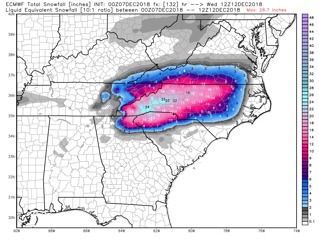
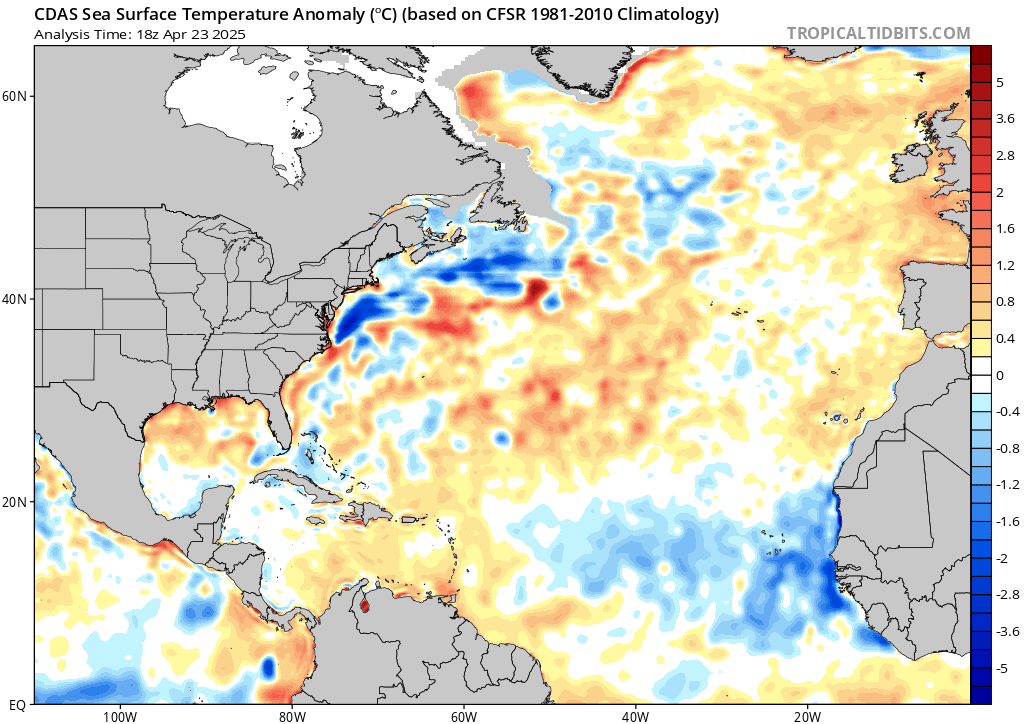
Anyway not to be an even bigger Debbie downer, but when forecasting winter storms, and where LP is likely to track once reaching the coast looking at the SSTA can offer guidance as to where the tendencies of the LP track will be. The reasoning behind this idea is that where there are warmer than normal SSTA the tendencies for air to rise over the warmer anomalies increases which lowers pressures in these areas. A LP center developing off the coast or reaching the coast will often times follow that path of least resistance. ie: LP falls into the areas of "lower pressures out ahead of it typically along these warm SSTA. Looking at the current SSTA off the EC one can plainly see where the warmest SSTA are currently, and when comparing to the spread in the Euro Ensemble mean for this upcoming system one can also plainly see it appears to follow this rule quite nicely. Now this is a general rule, and there are many factors that will ultimately dictate the final track of any given system, but Doc this lends some credence to your concerns of a cold dry winter, esp for the areas N&W of the coastal plain, while areas to the south see the majority of the white gold IF the SSTA configuration along the EC were to persist as is.
WE ALL MUST KEEP IN MIND...A FAVORABLE PATTERN DOESNT MEAN SNOW IS INEVITABLE, AS WELL AS AN UNFAVORABLE PATTERN DOESNT MEAN WE WONT GGET SNOW EITHER. We have seen MANY times over the years where a sneaky system "pops out of nowhere" in an unfavorable or warm pattern to deliver the goods(Ray has outlined a possibility above), but we have also seen the "perfect setup" go awry where we end up with a miss so make sure as we cont to plod along this season(remember its only DEC 7th...it snowed IMBY through first 10days of April last year) to keep yourself in the middle regarding expectations.

_________________
"In weather and in life, there's no winning and losing; there's only winning and learning."
WINTER 2012/2013 TOTALS 43.65"WINTER 2017/2018 TOTALS 62.85" WINTER 2022/2023 TOTALS 4.9"
WINTER 2013/2014 TOTALS 64.85"WINTER 2018/2019 TOTALS 14.25" WINTER 2023/2024 TOTALS 13.1"
WINTER 2014/2015 TOTALS 71.20"WINTER 2019/2020 TOTALS 6.35"
WINTER 2015/2016 TOTALS 35.00"WINTER 2020/2021 TOTALS 37.75"
WINTER 2016/2017 TOTALS 42.25"WINTER 2021/2022 TOTALS 31.65"

sroc4- Admin

- Posts : 8354
Reputation : 302
Join date : 2013-01-07
Location : Wading River, LI
 Re: December 2018 Observations and Discussions
Nice post Scott.
There are many factors that lead to a favorable pattern. Just because it is cold it does not mean the pattern favors snowstorms. You need an organized trough with energy consolidating at its base, or a polar jet stream positioned over us to get some clipper-like storms. Those are unlikely in the El Nino base state we're in, however. Point being, the cold/dry conditions do stink but its for a reason. The ridging across the mid-section of the country into Canada is very persistent. Somehow, we need to break it.
There are many factors that lead to a favorable pattern. Just because it is cold it does not mean the pattern favors snowstorms. You need an organized trough with energy consolidating at its base, or a polar jet stream positioned over us to get some clipper-like storms. Those are unlikely in the El Nino base state we're in, however. Point being, the cold/dry conditions do stink but its for a reason. The ridging across the mid-section of the country into Canada is very persistent. Somehow, we need to break it.
_________________
_______________________________________________________________________________________________________
CLICK HERE to view NJ Strong Snowstorm Classifications
 Re: December 2018 Observations and Discussions
Frank_Wx wrote:Nice post Scott.
There are many factors that lead to a favorable pattern. Just because it is cold it does not mean the pattern favors snowstorms. You need an organized trough with energy consolidating at its base, or a polar jet stream positioned over us to get some clipper-like storms. Those are unlikely in the El Nino base state we're in, however. Point being, the cold/dry conditions do stink but its for a reason. The ridging across the mid-section of the country into Canada is very persistent. Somehow, we need to break it.
Great informative posts out of both you guys. Frank to your point about the ridging in the mid-section.....weren’t forecasters able to see this sooner. Everyone harped on the first 10 days of December but didn’t see the ridge or SS’Ts?
Beyond frustrating
Guest- Guest
 Re: December 2018 Observations and Discussions
Wow, that SST map Doc posted above tells the tale of this storm's track.It's positioned right over the favorable warmer areas of the ocean.I remember reading one site's long range winter forecast that the mid Atlantic is the jackpot zone this year with a storm track set like this one to come this weekend.We have two strikes against us right now, these SST's and then ridging Frank mentions.Hope this is not set in concrete for the whole winter.
Partly cloudy, windy, cold 34 degrees.
Partly cloudy, windy, cold 34 degrees.

docstox12- Wx Statistician Guru

- Posts : 8530
Reputation : 222
Join date : 2013-01-07
Age : 73
Location : Monroe NY
 Re: December 2018 Observations and Discussions
docstox12 wrote:Wow, that SST map Doc posted above tells the tale of this storm's track.It's positioned right over the favorable warmer areas of the ocean.I remember reading one site's long range winter forecast that the mid Atlantic is the jackpot zone this year with a storm track set like this one to come this weekend.We have two strikes against us right now, these SST's and then ridging Frank mentions.Hope this is not set in concrete for the whole winter.
Partly cloudy, windy, cold 34 degrees.
Not good doc. Not good
Guest- Guest
 Re: December 2018 Observations and Discussions
It's actually sad Jimmy for us snow lovers.Taking the glass half full angle, at least there is a Christmas feel out there.Hope the curse of the "early snowstorm of 2012" doesn't bite us in the arse this year.syosnow94 wrote:docstox12 wrote:Wow, that SST map Doc posted above tells the tale of this storm's track.It's positioned right over the favorable warmer areas of the ocean.I remember reading one site's long range winter forecast that the mid Atlantic is the jackpot zone this year with a storm track set like this one to come this weekend.We have two strikes against us right now, these SST's and then ridging Frank mentions.Hope this is not set in concrete for the whole winter.
Partly cloudy, windy, cold 34 degrees.
Not good doc. Not good

docstox12- Wx Statistician Guru

- Posts : 8530
Reputation : 222
Join date : 2013-01-07
Age : 73
Location : Monroe NY
 Re: December 2018 Observations and Discussions
syosnow94 wrote:Frank_Wx wrote:Nice post Scott.
There are many factors that lead to a favorable pattern. Just because it is cold it does not mean the pattern favors snowstorms. You need an organized trough with energy consolidating at its base, or a polar jet stream positioned over us to get some clipper-like storms. Those are unlikely in the El Nino base state we're in, however. Point being, the cold/dry conditions do stink but its for a reason. The ridging across the mid-section of the country into Canada is very persistent. Somehow, we need to break it.
Great informative posts out of both you guys. Frank to your point about the ridging in the mid-section.....weren’t forecasters able to see this sooner. Everyone harped on the first 10 days of December but didn’t see the ridge or SS’Ts?
Beyond frustrating
It depends who you use as your source. Speaking for me personally, I've stated my concerns regarding the ridge being too far east in the long range thread on a couple of occasions.
https://www.njstrongweatherforum.com/t935p250-long-range-thread-17-0
I have a couple of posts from November stating the pattern isn't great (because of the ridge position). I also acknowledge the threat on the 10th but still mention it's not an ideal pattern.
_________________
_______________________________________________________________________________________________________
CLICK HERE to view NJ Strong Snowstorm Classifications
 Re: December 2018 Observations and Discussions
Frank_Wx wrote:syosnow94 wrote:Frank_Wx wrote:Nice post Scott.
There are many factors that lead to a favorable pattern. Just because it is cold it does not mean the pattern favors snowstorms. You need an organized trough with energy consolidating at its base, or a polar jet stream positioned over us to get some clipper-like storms. Those are unlikely in the El Nino base state we're in, however. Point being, the cold/dry conditions do stink but its for a reason. The ridging across the mid-section of the country into Canada is very persistent. Somehow, we need to break it.
Great informative posts out of both you guys. Frank to your point about the ridging in the mid-section.....weren’t forecasters able to see this sooner. Everyone harped on the first 10 days of December but didn’t see the ridge or SS’Ts?
Beyond frustrating
It depends who you use as your source. Speaking for me personally, I've stated my concerns regarding the ridge being too far east in the long range thread on a couple of occasions.
https://www.njstrongweatherforum.com/t935p250-long-range-thread-17-0
Unfortunately I know Frank. I remember. With you being so busy and not
Posting as much as the old Days I’ve started listening a little more to others
I have a couple of posts from November stating the pattern isn't great (because of the ridge position). I also acknowledge the threat on the 10th but still mention it's not an ideal pattern.
Guest- Guest
 Re: December 2018 Observations and Discussions
17* at the Shore right now. I opened the screen door to get a taste of that air and it attacked me!
I've had 0.00" so far.
It could be like the winter of 2015/2016- Not a hint of snow until the Jan 24 2016 blizzard and then a pretty good 6 weeks after that
Or it could be like the winter of 2016/2017- Not a hint of snow until a 7" storm on Jan 7, and then NOTHING but misses and rain and duckfart storms the rest of the way.
Jan and Mar have been the big snow months for me...until then I'm gonna do the old wait, watch, track, wince, reload. sucks right now, but I'm a snow weenie, so it's all I really know
SENJsnowman- Senior Enthusiast

- Posts : 1189
Reputation : 61
Join date : 2017-01-06
Age : 51
Location : Bayville, NJ
 Re: December 2018 Observations and Discussions
28* with some snow flurries here. An unexpected treat.

billg315- Advanced Forecaster - Mod

- Posts : 4483
Reputation : 185
Join date : 2015-01-24
Age : 50
Location : Flemington, NJ
 Re: December 2018 Observations and Discussions
Same here billg, snow flurry mood flakes and cold to keep the Christmas Spirit!

docstox12- Wx Statistician Guru

- Posts : 8530
Reputation : 222
Join date : 2013-01-07
Age : 73
Location : Monroe NY
 Re: December 2018 Observations and Discussions
Nice heavy burst of snow the last 20 minutes or so light coating on grass and even the sidewalk nice mood flakes

algae888- Advanced Forecaster

- Posts : 5311
Reputation : 46
Join date : 2013-02-05
Age : 62
Location : mt. vernon, new york
 Re: December 2018 Observations and Discussions
We’ve had flurries here too. Your heavy squall moving right at me
Guest- Guest
 Re: December 2018 Observations and Discussions
On my drive into work across the north shore of Long Island this morning I noticed EVERY fresh water pond was frozen over. Temperature was 27. Early in the year for this to happen and the next few days should add to it. Then we get some heavy rain. YESSSS!!
Guest- Guest
Page 1 of 14 • 1, 2, 3 ... 7 ... 14 
Page 1 of 14
Permissions in this forum:
You cannot reply to topics in this forum|
|
|

 Home
Home