December 2018 Observations and Discussions
+27
oldtimer
heehaw453
crippo84
Sanchize06
GreyBeard
CPcantmeasuresnow
SoulSingMG
aiannone
hyde345
mwilli5783
nutleyblizzard
Radz
rb924119
Vinnydula
jmanley32
skinsfan1177
weatherwatchermom
algae888
SENJsnowman
Frank_Wx
sroc4
frank 638
billg315
dkodgis
docstox12
amugs
Dunnzoo
31 posters
Page 3 of 14
Page 3 of 14 •  1, 2, 3, 4 ... 8 ... 14
 Re: December 2018 Observations and Discussions
Nice easterly fetch in the low and mid levels with warm air advection over top I think some places are going to be surprised today wouldn't be surprised to see three or four inches some areas north and west of the city
algae888- Advanced Forecaster

- Posts : 5311
Join date : 2013-02-05
 Re: December 2018 Observations and Discussions
Regarding Monday:
The 500mb energy associated with this weekend's rain storm (located SE of New England) and the energy across the Great Lakes trended in the wrong direction last night. There is no phasing, nor partial phasing, to allow snow to develop over the area. We need these two entities much closer together to have a chance of some snow Monday.

Granted I'm only looking at the GFS. I'm not sure what the EURO is thinking.
The 500mb energy associated with this weekend's rain storm (located SE of New England) and the energy across the Great Lakes trended in the wrong direction last night. There is no phasing, nor partial phasing, to allow snow to develop over the area. We need these two entities much closer together to have a chance of some snow Monday.

Granted I'm only looking at the GFS. I'm not sure what the EURO is thinking.
 Re: December 2018 Observations and Discussions
A nice coating of snow picking up in intensity nice band coming into Western New Jersey now let's see if we can get an inch in my area and get on the board for December

algae888- Advanced Forecaster

- Posts : 5311
Reputation : 46
Join date : 2013-02-05
Age : 62
Location : mt. vernon, new york
 Re: December 2018 Observations and Discussions
Frank_Wx wrote:Regarding Monday:
The 500mb energy associated with this weekend's rain storm (located SE of New England) and the energy across the Great Lakes trended in the wrong direction last night. There is no phasing, nor partial phasing, to allow snow to develop over the area. We need these two entities much closer together to have a chance of some snow Monday.
Granted I'm only looking at the GFS. I'm not sure what the EURO is thinking.
Of course it did. What a surprise More disappointment incoming. If this continues to trend badly in future model runs Not a good start to this DJF period. Things haven’t gone our way
Guest- Guest
 Re: December 2018 Observations and Discussions
Been snowing since 7am. Nothing is sticking. It's drying up once it hits the ground

Vinnydula- Pro Enthusiast

- Posts : 778
Reputation : 8
Join date : 2013-12-12
Location : Dobbs ferry
 Re: December 2018 Observations and Discussions
Yeah it's snowing pretty good here right now just a coating of snow only on the coldest surfacesVinnydula wrote:Been snowing since 7am. Nothing is sticking. It's drying up once it hits the ground

algae888- Advanced Forecaster

- Posts : 5311
Reputation : 46
Join date : 2013-02-05
Age : 62
Location : mt. vernon, new york
 Re: December 2018 Observations and Discussions
algae888 wrote:Yeah it's snowing pretty good here right now just a coating of snow only on the coldest surfacesVinnydula wrote:Been snowing since 7am. Nothing is sticking. It's drying up once it hits the ground
Mood flakes?
_________________
"In weather and in life, there's no winning and losing; there's only winning and learning."
WINTER 2012/2013 TOTALS 43.65"WINTER 2017/2018 TOTALS 62.85" WINTER 2022/2023 TOTALS 4.9"
WINTER 2013/2014 TOTALS 64.85"WINTER 2018/2019 TOTALS 14.25" WINTER 2023/2024 TOTALS 13.1"
WINTER 2014/2015 TOTALS 71.20"WINTER 2019/2020 TOTALS 6.35"
WINTER 2015/2016 TOTALS 35.00"WINTER 2020/2021 TOTALS 37.75"
WINTER 2016/2017 TOTALS 42.25"WINTER 2021/2022 TOTALS 31.65"

sroc4- Admin

- Posts : 8354
Reputation : 302
Join date : 2013-01-07
Location : Wading River, LI
 Re: December 2018 Observations and Discussions
sroc4 wrote:algae888 wrote:Yeah it's snowing pretty good here right now just a coating of snow only on the coldest surfacesVinnydula wrote:Been snowing since 7am. Nothing is sticking. It's drying up once it hits the ground
Mood flakes?
That sums it up Doc.Underperformed here, NWS had 1 to 2 inches, and with the radar showing it's over, barely 1/4 inch.

docstox12- Wx Statistician Guru

- Posts : 8530
Reputation : 222
Join date : 2013-01-07
Age : 73
Location : Monroe NY
 Re: December 2018 Observations and Discussions
Nice coating here on grass and roads with no traffic.
_________________
Janet
Snowfall winter of 2023-2024 17.5"
Snowfall winter of 2022-2023 6.0"
Snowfall winter of 2021-2022 17.6" 1" sleet 2/25/22
Snowfall winter of 2020-2021 51.1"
Snowfall winter of 2019-2020 8.5"
Snowfall winter of 2018-2019 25.1"
Snowfall winter of 2017-2018 51.9"
Snowfall winter of 2016-2017 45.6"
Snowfall winter of 2015-2016 29.5"
Snowfall winter of 2014-2015 50.55"
Snowfall winter of 2013-2014 66.5"

Dunnzoo- Senior Enthusiast - Mod

- Posts : 4905
Reputation : 68
Join date : 2013-01-11
Age : 62
Location : Westwood, NJ
 Re: December 2018 Observations and Discussions
I had a few flurries around 9 or so, but its a very light drizzle now.
_________________
"In weather and in life, there's no winning and losing; there's only winning and learning."
WINTER 2012/2013 TOTALS 43.65"WINTER 2017/2018 TOTALS 62.85" WINTER 2022/2023 TOTALS 4.9"
WINTER 2013/2014 TOTALS 64.85"WINTER 2018/2019 TOTALS 14.25" WINTER 2023/2024 TOTALS 13.1"
WINTER 2014/2015 TOTALS 71.20"WINTER 2019/2020 TOTALS 6.35"
WINTER 2015/2016 TOTALS 35.00"WINTER 2020/2021 TOTALS 37.75"
WINTER 2016/2017 TOTALS 42.25"WINTER 2021/2022 TOTALS 31.65"

sroc4- Admin

- Posts : 8354
Reputation : 302
Join date : 2013-01-07
Location : Wading River, LI
 Re: December 2018 Observations and Discussions
Not even a drop of mood drizzle..lol

weatherwatchermom- Senior Enthusiast

- Posts : 3793
Reputation : 78
Join date : 2014-11-25
Location : Hazlet Township, NJ
 Re: December 2018 Observations and Discussions
docstox12 wrote:Underperformed here
The story of December? So far looks like it...
Still so early in the game, though...I'm way geeked for the next several weeks. And at least all this cold has the ground and air primed for when the pattern does come together. I'm even getting sucked in to the optimism for next week! Ha ha...just can't help myself.
SENJsnowman- Senior Enthusiast

- Posts : 1189
Reputation : 61
Join date : 2017-01-06
Age : 51
Location : Bayville, NJ
 Re: December 2018 Observations and Discussions
Heavy snow now. To bad it haven't stuck

Vinnydula- Pro Enthusiast

- Posts : 778
Reputation : 8
Join date : 2013-12-12
Location : Dobbs ferry
 Re: December 2018 Observations and Discussions
Ended up with about .25" on grassy surfaces, stayed at about 31* all day. Had a light drizzle this afternoon mixed in with snow, so things are icing up a little.
_________________
Janet
Snowfall winter of 2023-2024 17.5"
Snowfall winter of 2022-2023 6.0"
Snowfall winter of 2021-2022 17.6" 1" sleet 2/25/22
Snowfall winter of 2020-2021 51.1"
Snowfall winter of 2019-2020 8.5"
Snowfall winter of 2018-2019 25.1"
Snowfall winter of 2017-2018 51.9"
Snowfall winter of 2016-2017 45.6"
Snowfall winter of 2015-2016 29.5"
Snowfall winter of 2014-2015 50.55"
Snowfall winter of 2013-2014 66.5"

Dunnzoo- Senior Enthusiast - Mod

- Posts : 4905
Reputation : 68
Join date : 2013-01-11
Age : 62
Location : Westwood, NJ
 Re: December 2018 Observations and Discussions
Models cut back on rain totals significantly, especially for areas N&W of NYC. It appears the High Pressure to the north is keeping the low pressure further south. I'm wondering if these "southern sliders" storms become a trend this winter. That could be...uh...crappy.
But anyways, here is the NAM rain totals map:

And GFS:

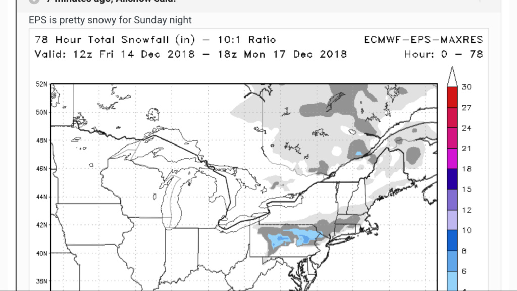
This is a far cry from the 2+ inch amounts shown yesterday. Also, Saturday is beginning to look like the BETTER day of the weekend. There is a chance it stops raining by early afternoon Saturday. Then rain will resume on Sunday from Wave #2. I also continue to watch for possible snow N&W of NYC Sunday night into Monday.
But anyways, here is the NAM rain totals map:

And GFS:

This is a far cry from the 2+ inch amounts shown yesterday. Also, Saturday is beginning to look like the BETTER day of the weekend. There is a chance it stops raining by early afternoon Saturday. Then rain will resume on Sunday from Wave #2. I also continue to watch for possible snow N&W of NYC Sunday night into Monday.
_________________
_______________________________________________________________________________________________________
CLICK HERE to view NJ Strong Snowstorm Classifications
 Re: December 2018 Observations and Discussions
Frank_Wx wrote:Models cut back on rain totals significantly, especially for areas N&W of NYC. It appears the High Pressure to the north is keeping the low pressure further south. I'm wondering if these "southern sliders" storms become a trend this winter. That could be...uh...crappy.
.
Your not kidding. Recall the discussion a week ago in regards to the track of the system that dumped 1-2feet in parts of NC and Va.
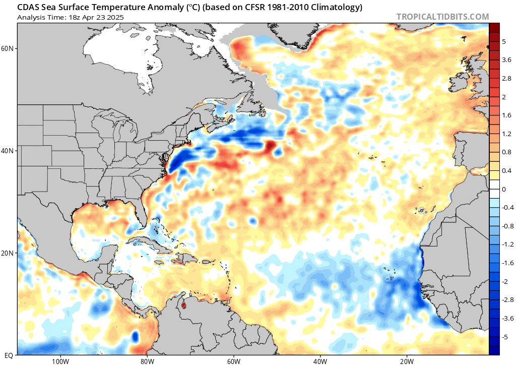
Anyway not to be an even bigger Debbie downer, but when forecasting winter storms, and where LP is likely to track once reaching the coast looking at the SSTA can offer guidance as to where the tendencies of the LP track will be. The reasoning behind this idea is that where there are warmer than normal SSTA the tendencies for air to rise over the warmer anomalies increases which lowers pressures in these areas. A LP center developing off the coast or reaching the coast will often times follow that path of least resistance. ie: LP falls into the areas of "lower pressures out ahead of it typically along these warm SSTA. Looking at the current SSTA off the EC one can plainly see where the warmest SSTA are currently, and when comparing to the spread in the Euro Ensemble mean for this upcoming system one can also plainly see it appears to follow this rule quite nicely. Now this is a general rule, and there are many factors that will ultimately dictate the final track of any given system, but Doc this lends some credence to your concerns of a cold dry winter, esp for the areas N&W of the coastal plain, while areas to the south see the majority of the white gold IF the SSTA configuration along the EC were to persist as is.

Hopefully this is more related to the pattern as a whole versus a true tale of things to come. And with the things to come in the strat etc the re shuffling of the deck will change this. I for one think it will, and I remain fairly confident overall, but I can def see how if we do miss on a system throughout this winter a southern miss would likely be favored.
_________________
"In weather and in life, there's no winning and losing; there's only winning and learning."
WINTER 2012/2013 TOTALS 43.65"WINTER 2017/2018 TOTALS 62.85" WINTER 2022/2023 TOTALS 4.9"
WINTER 2013/2014 TOTALS 64.85"WINTER 2018/2019 TOTALS 14.25" WINTER 2023/2024 TOTALS 13.1"
WINTER 2014/2015 TOTALS 71.20"WINTER 2019/2020 TOTALS 6.35"
WINTER 2015/2016 TOTALS 35.00"WINTER 2020/2021 TOTALS 37.75"
WINTER 2016/2017 TOTALS 42.25"WINTER 2021/2022 TOTALS 31.65"

sroc4- Admin

- Posts : 8354
Reputation : 302
Join date : 2013-01-07
Location : Wading River, LI
 Re: December 2018 Observations and Discussions
Yes, great post from back then Scott.
_________________
_______________________________________________________________________________________________________
CLICK HERE to view NJ Strong Snowstorm Classifications
 Re: December 2018 Observations and Discussions
N&W of NYC...NAM says hello


_________________
_______________________________________________________________________________________________________
CLICK HERE to view NJ Strong Snowstorm Classifications
 Re: December 2018 Observations and Discussions
Wow 12km nam lays down 4 to 8 for the areas even just nw of NYC including Westchester. This would be great give me a 3 day weekend plz.

jmanley32- Senior Enthusiast

- Posts : 20535
Reputation : 108
Join date : 2013-12-12
Age : 43
Location : Yonkers, NY
 Re: December 2018 Observations and Discussions
Frank_Wx wrote:N&W of NYC...NAM says hello
Now THIS would be a very pleasant surprise and get some snow OTG to exponentially increase the Holiday mood! A good winter has these surprises baked in the cake, let's hope it comes!
Cloudy, raw getting staged for some rain.

docstox12- Wx Statistician Guru

- Posts : 8530
Reputation : 222
Join date : 2013-01-07
Age : 73
Location : Monroe NY
 Re: December 2018 Observations and Discussions
syosnow94 wrote:Hey rb any chance the coast gets into some of this? Especially if we continue the recent southerly shifts in storms as the event draws closer!rb924119 wrote:EURO tipped considerably to the NAM, although it isn’t quite ready to fully pull the trigger........yet. Don’t worry, though, because I expect it to
_________________
"In weather and in life, there's no winning and losing; there's only winning and learning."
WINTER 2012/2013 TOTALS 43.65"WINTER 2017/2018 TOTALS 62.85" WINTER 2022/2023 TOTALS 4.9"
WINTER 2013/2014 TOTALS 64.85"WINTER 2018/2019 TOTALS 14.25" WINTER 2023/2024 TOTALS 13.1"
WINTER 2014/2015 TOTALS 71.20"WINTER 2019/2020 TOTALS 6.35"
WINTER 2015/2016 TOTALS 35.00"WINTER 2020/2021 TOTALS 37.75"
WINTER 2016/2017 TOTALS 42.25"WINTER 2021/2022 TOTALS 31.65"

sroc4- Admin

- Posts : 8354
Reputation : 302
Join date : 2013-01-07
Location : Wading River, LI
 Re: December 2018 Observations and Discussions
Unfortunately, syo, I think I-95 is the cutoff for any measurable frozen precipitation. :/
rb924119- Meteorologist

- Posts : 6928
Reputation : 194
Join date : 2013-02-06
Age : 32
Location : Greentown, Pa
 Re: December 2018 Observations and Discussions
jmanley32 wrote:Wow 12km nam lays down 4 to 8 for the areas even just nw of NYC including Westchester. This would be great give me a 3 day weekend plz.
JMAN a lot of that is sleet at this time with some snow on the backened for us areas- ice ice baby and mixed precip be contend there.
I do expect it come around for us N & W.
_________________
Mugs
AKA:King: Snow Weenie
Self Proclaimed
WINTER 2014-15 : 55.12" +.02 for 6 coatings (avg. 35")
WINTER 2015-16 Total - 29.8" (Avg 35")
WINTER 2016-17 : 39.5" so far

amugs- Advanced Forecaster - Mod

- Posts : 15095
Reputation : 213
Join date : 2013-01-07
Age : 54
Location : Hillsdale,NJ
rb924119- Meteorologist

- Posts : 6928
Reputation : 194
Join date : 2013-02-06
Age : 32
Location : Greentown, Pa
 Re: December 2018 Observations and Discussions
That is a good look for a storm that was prigged to be a soaker up to Buffalo, see what an igloo to our North can do with some storm dynamics.
Need a 30 mile shift SE if possible and many here dance in the white gold.
Need a 30 mile shift SE if possible and many here dance in the white gold.
_________________
Mugs
AKA:King: Snow Weenie
Self Proclaimed
WINTER 2014-15 : 55.12" +.02 for 6 coatings (avg. 35")
WINTER 2015-16 Total - 29.8" (Avg 35")
WINTER 2016-17 : 39.5" so far

amugs- Advanced Forecaster - Mod

- Posts : 15095
Reputation : 213
Join date : 2013-01-07
Age : 54
Location : Hillsdale,NJ
 Re: December 2018 Observations and Discussions
Not looking forward to an ice storm but if I don't have go work Monday I don't care lol

jmanley32- Senior Enthusiast

- Posts : 20535
Reputation : 108
Join date : 2013-12-12
Age : 43
Location : Yonkers, NY
 Re: December 2018 Observations and Discussions
Yes I know this was supposed to be rain and now maybe some
N and W areas may see some
Frozen BUT doesn’t this just show 1-3” for the majority of our board at most? If so why the excitement?
Guest- Guest
Page 3 of 14 •  1, 2, 3, 4 ... 8 ... 14
Page 3 of 14
Permissions in this forum:
You cannot reply to topics in this forum|
|
|

 Home
Home