JAN 12th-13th 2019 Snow threat
+19
docstox12
bobjohnsonforthehall
billg315
Snow88
CPcantmeasuresnow
Frank_Wx
skinsfan1177
nutleyblizzard
aiannone
SoulSingMG
amugs
crippo84
Grselig
rb924119
Carvin
mikeypizano
SENJsnowman
jmanley32
sroc4
23 posters
Page 1 of 4 • 1, 2, 3, 4 
 JAN 12th-13th 2019 Snow threat
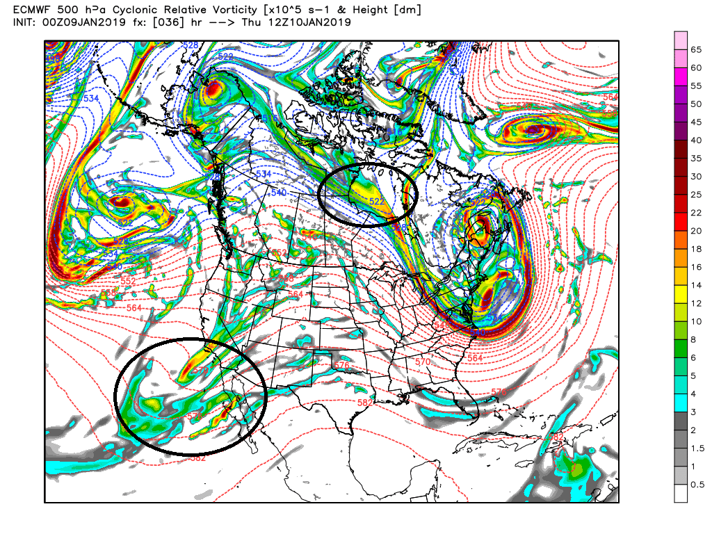
Keep in mind that the energy that will be our system is still well out in the Pac. and the energy that is the steering mechanism aka creates the confluence/N Trough is just now into N Canada.

Here is the energy that will be our system in 36hrs....still just coming ashore.
A few other comments. 1st the GFS although has shifted back to a more strung out system at 06z it has also been the most inconsistent with many of these features from run to run so for now I trust the least. While the GFS may have shifted to a more sheared out system at 500mb the NAM has not. It still shows a stronger more consolidated system over the heartland of the nation at 500mb.
GFS vs NAM


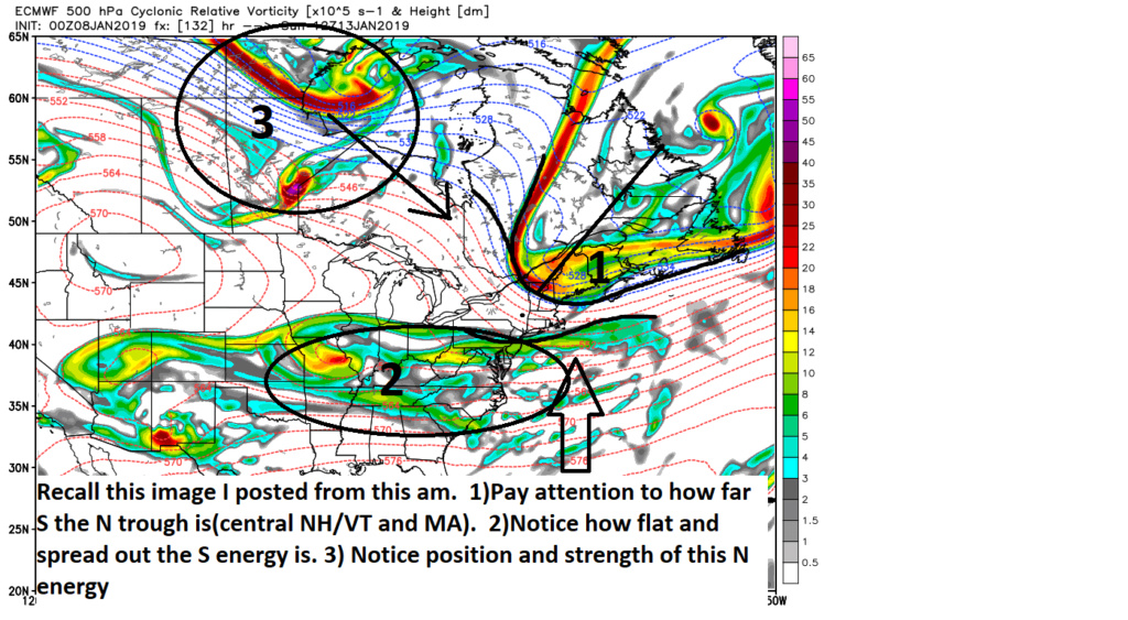
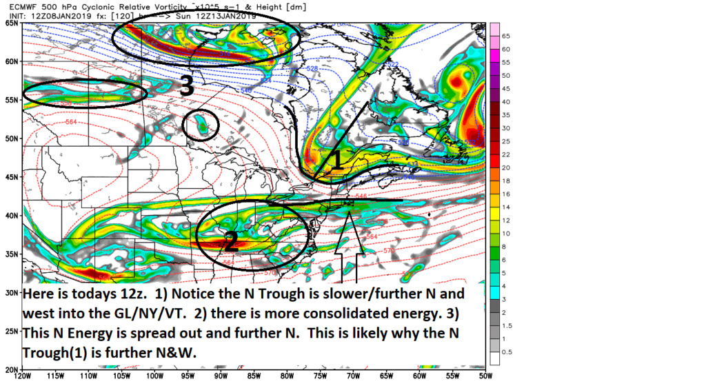
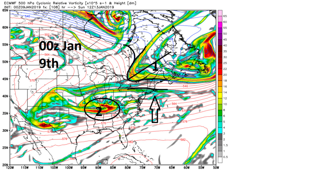
Recall the discussion yest morning when I compared 00z Jan 8th to 12z Jan 7th. Specifically regarding the strength and positioning of the N Trough and the strength and positioning of the S energy and how far N it can make it. While it still has a ways to go for a "significant event, the euro conts to slow and steady tick more positive. The 3 images below are valid for the same time frame 12z Jan 13th. Pay attention to the trend for the N Trough to shift N&W with successive runs and the S energy to be a tad stronger, more consolidated, and allowed to trend N along the coast. Again its subtle but steady. Remember subtle shift at this level in the atmosphere can pay big dividends at the surface.
Here is the snow map for the euro at a 15:1 ratio. This will be a high ratio event. As high as 15:1-25:1 even in central to southern NJ. 925-850mb temps look to be -5 to -9 across the board and surface temps in the twenties while any precip moves in. Those ratios would only go down if the storm track makes a significant shift towards the BM, but if that happens the amt of QPF significantly goes up as well which would easily compensate for a shift down in ratio. CP if your reading you are absolutely correct in keeping of the mind set of having to deal with virga and no snow but it aint ova for you boys and gals yet either to the N. Honestly even NYC and N should at least consider that. CNJ on south looks like they could be in for a decent high ratio event to kick this winter off.


Here is the energy that will be our system in 36hrs....still just coming ashore.

A few other comments. 1st the GFS although has shifted back to a more strung out system at 06z it has also been the most inconsistent with many of these features from run to run so for now I trust the least. While the GFS may have shifted to a more sheared out system at 500mb the NAM has not. It still shows a stronger more consolidated system over the heartland of the nation at 500mb.
GFS vs NAM


Recall the discussion yest morning when I compared 00z Jan 8th to 12z Jan 7th. Specifically regarding the strength and positioning of the N Trough and the strength and positioning of the S energy and how far N it can make it. While it still has a ways to go for a "significant event, the euro conts to slow and steady tick more positive. The 3 images below are valid for the same time frame 12z Jan 13th. Pay attention to the trend for the N Trough to shift N&W with successive runs and the S energy to be a tad stronger, more consolidated, and allowed to trend N along the coast. Again its subtle but steady. Remember subtle shift at this level in the atmosphere can pay big dividends at the surface.


Here is the snow map for the euro at a 15:1 ratio. This will be a high ratio event. As high as 15:1-25:1 even in central to southern NJ. 925-850mb temps look to be -5 to -9 across the board and surface temps in the twenties while any precip moves in. Those ratios would only go down if the storm track makes a significant shift towards the BM, but if that happens the amt of QPF significantly goes up as well which would easily compensate for a shift down in ratio. CP if your reading you are absolutely correct in keeping of the mind set of having to deal with virga and no snow but it aint ova for you boys and gals yet either to the N. Honestly even NYC and N should at least consider that. CNJ on south looks like they could be in for a decent high ratio event to kick this winter off.

Last edited by sroc4 on Thu Jan 10, 2019 7:04 am; edited 1 time in total
_________________
"In weather and in life, there's no winning and losing; there's only winning and learning."
WINTER 2012/2013 TOTALS 43.65"WINTER 2017/2018 TOTALS 62.85" WINTER 2022/2023 TOTALS 4.9"
WINTER 2013/2014 TOTALS 64.85"WINTER 2018/2019 TOTALS 14.25" WINTER 2023/2024 TOTALS 13.1"
WINTER 2014/2015 TOTALS 71.20"WINTER 2019/2020 TOTALS 6.35"
WINTER 2015/2016 TOTALS 35.00"WINTER 2020/2021 TOTALS 37.75"
WINTER 2016/2017 TOTALS 42.25"WINTER 2021/2022 TOTALS 31.65"

sroc4- Admin

- Posts : 8354
Reputation : 302
Join date : 2013-01-07
Location : Wading River, LI
 Re: JAN 12th-13th 2019 Snow threat
Also here is the latest GFS vs its own supposed "upgrade" FV3-GFS where FV3 is still a more consolidated system and significantly further N.


_________________
"In weather and in life, there's no winning and losing; there's only winning and learning."
WINTER 2012/2013 TOTALS 43.65"WINTER 2017/2018 TOTALS 62.85" WINTER 2022/2023 TOTALS 4.9"
WINTER 2013/2014 TOTALS 64.85"WINTER 2018/2019 TOTALS 14.25" WINTER 2023/2024 TOTALS 13.1"
WINTER 2014/2015 TOTALS 71.20"WINTER 2019/2020 TOTALS 6.35"
WINTER 2015/2016 TOTALS 35.00"WINTER 2020/2021 TOTALS 37.75"
WINTER 2016/2017 TOTALS 42.25"WINTER 2021/2022 TOTALS 31.65"

sroc4- Admin

- Posts : 8354
Reputation : 302
Join date : 2013-01-07
Location : Wading River, LI
 Re: JAN 12th-13th 2019 Snow threat
Well all we can do is wait and see. Hi all. Work and life is taking much of my time so I do not get to check in or comment often. Not feeling too hopeful but we will see.

jmanley32- Senior Enthusiast

- Posts : 20535
Reputation : 108
Join date : 2013-12-12
Age : 43
Location : Yonkers, NY
 Re: JAN 12th-13th 2019 Snow threat
Northern energy looks noticeably more north on FV3...that's a big part too, right? getting the northern piece out of the way, so the storm can come up coast?
SENJsnowman- Senior Enthusiast

- Posts : 1189
Reputation : 61
Join date : 2017-01-06
Age : 51
Location : Bayville, NJ
 Re: JAN 12th-13th 2019 Snow threat
By looks of that map I see a coating to an inch, lovely...

mikeypizano- Pro Enthusiast

- Posts : 1118
Reputation : 66
Join date : 2017-01-05
Age : 35
Location : Wilkes-Barre/Scranton, PA
 Re: JAN 12th-13th 2019 Snow threat
Hello guys and gals nice to meet everyone i been following since accuweather blogs. And finally decided to join.quick ? Shouldn't the nam be more reliable at this stage then the bigger models
Carvin- Posts : 44
Reputation : 2
Join date : 2019-01-09
 Re: JAN 12th-13th 2019 Snow threat
Since the man with one eye is king in the land of the blind, I'm our block's resident wx 'expert'. Here's what I told all the folks at the bus stop just now (remember we are Shore folk down here, Very south and very east): "A third, A third, A third. One-third chance that the 2-3" hits, one-third chance it busts low and a one third chance it busts high. We'll know more by Friday" That's the way I see it as of now...
Welcome Carvin, I think maybe another 24-36 hours before we are really in the NAM's zone, but def like that it's picking up on things already.
Welcome Carvin, I think maybe another 24-36 hours before we are really in the NAM's zone, but def like that it's picking up on things already.
SENJsnowman- Senior Enthusiast

- Posts : 1189
Reputation : 61
Join date : 2017-01-06
Age : 51
Location : Bayville, NJ
 Re: JAN 12th-13th 2019 Snow threat
Carvin wrote:Hello guys and gals nice to meet everyone i been following since accuweather blogs. And finally decided to join.quick ? Shouldn't the nam be more reliable at this stage then the bigger models
Welcome Carvin! You really never can make a definitive statement about one model over another. While models like say the euro consistently out perform other global models one always has to look at any model forecast with an objective eye because models like the GFS will occasionally score the coup. When we get powerful systems I think the NAM has been one of the better models at sniffing these things out in recent yrs. For now that is all we can say. Like I posted earlier the southern energy is still off shore. Today and tonight we will hopefully get a better handle as to how the N energy/steering energy will behave as it is on land. There may be some who say it doesn't matter but I disagree adamantly as time and time again models will under or over estimate the intensity of key pieces of energy only to correct as it comes on shore which has big down stream effects on the final outcome. Again time and time again under 72hrs the "zeroing" in on the details occurs often. We shall see. Cautious optimism conts to be the phrase of the day. Cheers and again welcome!!
_________________
"In weather and in life, there's no winning and losing; there's only winning and learning."
WINTER 2012/2013 TOTALS 43.65"WINTER 2017/2018 TOTALS 62.85" WINTER 2022/2023 TOTALS 4.9"
WINTER 2013/2014 TOTALS 64.85"WINTER 2018/2019 TOTALS 14.25" WINTER 2023/2024 TOTALS 13.1"
WINTER 2014/2015 TOTALS 71.20"WINTER 2019/2020 TOTALS 6.35"
WINTER 2015/2016 TOTALS 35.00"WINTER 2020/2021 TOTALS 37.75"
WINTER 2016/2017 TOTALS 42.25"WINTER 2021/2022 TOTALS 31.65"

sroc4- Admin

- Posts : 8354
Reputation : 302
Join date : 2013-01-07
Location : Wading River, LI
 Re: JAN 12th-13th 2019 Snow threat
Carvin wrote:Hello guys and gals nice to meet everyone i been following since accuweather blogs. And finally decided to join.quick ? Shouldn't the nam be more reliable at this stage then the bigger models
Welcome aboard, matey, to our weather-weary fanatical crew!!! Nice to see another name tag in the forum
rb924119- Meteorologist

- Posts : 6928
Reputation : 194
Join date : 2013-02-06
Age : 32
Location : Greentown, Pa
 Re: JAN 12th-13th 2019 Snow threat
Fantastic writeup this morning, Scott, and to Frank’s yesterday! Dunzoo (and Greslig), I sincerely apologize if my remark the other day came across as nasty - that was not the intent, AT ALL. It was meant to be read in more a “firm, but fair” type of tone, to drill in the point. I was tired of repeating myself st that point amongst other forums, to be honest. As for my sources: Ryan Maue, an acquaintance on another forum who spoke to friends he knows in the NWS, and I had a direct source also in the NWS tell me that he knew nothing about any data issues.
rb924119- Meteorologist

- Posts : 6928
Reputation : 194
Join date : 2013-02-06
Age : 32
Location : Greentown, Pa
 Re: JAN 12th-13th 2019 Snow threat
rb924119 wrote:Fantastic writeup this morning, Scott, and to Frank’s yesterday! Dunzoo (and Greslig), I sincerely apologize if my remark the other day came across as nasty - that was not the intent, AT ALL. It was meant to be read in more a “firm, but fair” type of tone, to drill in the point. I was tired of repeating myself st that point amongst other forums, to be honest. As for my sources: Ryan Maue, an acquaintance on another forum who spoke to friends he knows in the NWS, and I had a direct source also in the NWS tell me that he knew nothing about any data issues.
No offense taken. You are always classy and give great info.

Grselig- Senior Enthusiast

- Posts : 1408
Reputation : 140
Join date : 2013-03-04
Age : 54
Location : Wayne NJ
 Re: JAN 12th-13th 2019 Snow threat
The phrase wave spacing will likely be used in the next 24-48hrs. ie: NAM coming in and I like the wave spacing at the moment
_________________
"In weather and in life, there's no winning and losing; there's only winning and learning."
WINTER 2012/2013 TOTALS 43.65"WINTER 2017/2018 TOTALS 62.85" WINTER 2022/2023 TOTALS 4.9"
WINTER 2013/2014 TOTALS 64.85"WINTER 2018/2019 TOTALS 14.25" WINTER 2023/2024 TOTALS 13.1"
WINTER 2014/2015 TOTALS 71.20"WINTER 2019/2020 TOTALS 6.35"
WINTER 2015/2016 TOTALS 35.00"WINTER 2020/2021 TOTALS 37.75"
WINTER 2016/2017 TOTALS 42.25"WINTER 2021/2022 TOTALS 31.65"

sroc4- Admin

- Posts : 8354
Reputation : 302
Join date : 2013-01-07
Location : Wading River, LI
 Re: JAN 12th-13th 2019 Snow threat
Scott, it’s flatter than 06z to me so far - look at your thickness contours. Those are your shear vectors/steering flow (in a sense).
rb924119- Meteorologist

- Posts : 6928
Reputation : 194
Join date : 2013-02-06
Age : 32
Location : Greentown, Pa
 Re: JAN 12th-13th 2019 Snow threat
From what I could tell, the SREFs were flat too, but cannot concretely confirm this.
rb924119- Meteorologist

- Posts : 6928
Reputation : 194
Join date : 2013-02-06
Age : 32
Location : Greentown, Pa
 Re: JAN 12th-13th 2019 Snow threat
Flat as in good or badd
Carvin- Posts : 44
Reputation : 2
Join date : 2019-01-09
 Re: JAN 12th-13th 2019 Snow threat
Carvin wrote:Flat as in good or badd
Bad if you want more snow :/ ICON not currently looking good either, although I trust that model about as much as I trust the FV3.......I don’t lmao
rb924119- Meteorologist

- Posts : 6928
Reputation : 194
Join date : 2013-02-06
Age : 32
Location : Greentown, Pa
 Re: JAN 12th-13th 2019 Snow threat
rb924119 wrote:From what I could tell, the SREFs were flat too, but cannot concretely confirm this.
Boy you REALLY want your forecast to verify. LOL. A blip flatter yes
_________________
"In weather and in life, there's no winning and losing; there's only winning and learning."
WINTER 2012/2013 TOTALS 43.65"WINTER 2017/2018 TOTALS 62.85" WINTER 2022/2023 TOTALS 4.9"
WINTER 2013/2014 TOTALS 64.85"WINTER 2018/2019 TOTALS 14.25" WINTER 2023/2024 TOTALS 13.1"
WINTER 2014/2015 TOTALS 71.20"WINTER 2019/2020 TOTALS 6.35"
WINTER 2015/2016 TOTALS 35.00"WINTER 2020/2021 TOTALS 37.75"
WINTER 2016/2017 TOTALS 42.25"WINTER 2021/2022 TOTALS 31.65"

sroc4- Admin

- Posts : 8354
Reputation : 302
Join date : 2013-01-07
Location : Wading River, LI
 Re: JAN 12th-13th 2019 Snow threat
sroc4 wrote:rb924119 wrote:From what I could tell, the SREFs were flat too, but cannot concretely confirm this.
Boy you REALLY want your forecast to verify. LOL. A blip flatter yes
Well duhhhh lmao every forecaster does!! Haha but I said that because I saw the indies posted elsewhere, but I’m honestly too exhausted to look intently aha even if I wasn’t, being awake for 24 hours can start messing with your mind ahaha
rb924119- Meteorologist

- Posts : 6928
Reputation : 194
Join date : 2013-02-06
Age : 32
Location : Greentown, Pa
 Re: JAN 12th-13th 2019 Snow threat
rb924119 wrote:sroc4 wrote:rb924119 wrote:From what I could tell, the SREFs were flat too, but cannot concretely confirm this.
Boy you REALLY want your forecast to verify. LOL. A blip flatter yes
Well duhhhh lmao every forecaster does!! Haha but I said that because I saw the indies posted elsewhere, but I’m honestly too exhausted to look intently aha even if I wasn’t, being awake for 24 hours can start messing with your mind ahaha
Haha - I can always tell which direction things are trending based on who's adding the most comments, which in turn stems from an initial forecast of a potential upcoming event.
Always enjoy everyone's insight - the suspense is killing me! I'm obviously pulling for trends toward a more snowy outcome.

crippo84- Posts : 383
Reputation : 20
Join date : 2013-11-07
Age : 40
Location : East Village, NYC
 Re: JAN 12th-13th 2019 Snow threat
When no one's posting the 12z yet, it's because it aint good. And it aint...hugs the coast to about Va Bch and then Bon Voyage.
And 2 runs in a row now that low kicks out at SC and not NC. That's too far south even for south folks to cash in. Time to wiper back to the north...
And 2 runs in a row now that low kicks out at SC and not NC. That's too far south even for south folks to cash in. Time to wiper back to the north...
SENJsnowman- Senior Enthusiast

- Posts : 1189
Reputation : 61
Join date : 2017-01-06
Age : 51
Location : Bayville, NJ
 Re: JAN 12th-13th 2019 Snow threat
GEFS wiper effect
0Z

6Z

12Z - th pendulum swinging back??

From JB
The GFS is likely getting into its handoff to quick to the northern branch mode it likes to get into 4 days out, So we see it collapsing heights over the lakes and Ohio Valley at 84 hours.) or handing off to the northern branch) This looks to be an error to me, but perhaps this is the time it is right, But there are no changes in my thinking right now I think the Euro/NAM blend will be the best way to proceed going forward and there is no change in our ideas on the storm this weekend, I don't think this is a big deal for NYC ( 2-4) and think its 4-8 around DC for instance. Quite frankly this map shows what I think is coming, more or less, Euro 72 hour snow totals ending Monday morning There are some edge considerations but I dont expect a shift north to the experimental GFS at 06z But I dont think there is that much suppression either
0Z

6Z

12Z - th pendulum swinging back??

From JB
The GFS is likely getting into its handoff to quick to the northern branch mode it likes to get into 4 days out, So we see it collapsing heights over the lakes and Ohio Valley at 84 hours.) or handing off to the northern branch) This looks to be an error to me, but perhaps this is the time it is right, But there are no changes in my thinking right now I think the Euro/NAM blend will be the best way to proceed going forward and there is no change in our ideas on the storm this weekend, I don't think this is a big deal for NYC ( 2-4) and think its 4-8 around DC for instance. Quite frankly this map shows what I think is coming, more or less, Euro 72 hour snow totals ending Monday morning There are some edge considerations but I dont expect a shift north to the experimental GFS at 06z But I dont think there is that much suppression either
_________________
Mugs
AKA:King: Snow Weenie
Self Proclaimed
WINTER 2014-15 : 55.12" +.02 for 6 coatings (avg. 35")
WINTER 2015-16 Total - 29.8" (Avg 35")
WINTER 2016-17 : 39.5" so far

amugs- Advanced Forecaster - Mod

- Posts : 15095
Reputation : 213
Join date : 2013-01-07
Age : 54
Location : Hillsdale,NJ
 Re: JAN 12th-13th 2019 Snow threat
GFY 12z EURO!!! I will not be roped back in!!!

SoulSingMG- Senior Enthusiast

- Posts : 2853
Reputation : 74
Join date : 2013-12-11
Location : Long Island City, NY
 Re: JAN 12th-13th 2019 Snow threat
SoulSingMG wrote:GFY 12z EURO!!! I will not be roped back in!!!
Umm euro was a miss...
Light amount of qpf and even knock some off that due to dry arctic air. That was c-2” at best
_________________
-Alex Iannone-

aiannone- Senior Enthusiast - Mod

- Posts : 4815
Reputation : 92
Join date : 2013-01-07
Location : Saint James, LI (Northwest Suffolk Co.)
 Re: JAN 12th-13th 2019 Snow threat
aiannone wrote:SoulSingMG wrote:GFY 12z EURO!!! I will not be roped back in!!!
Umm euro was a miss...
Light amount of qpf and even knock some off that due to dry arctic air. That was c-2” at best
Compared to its previous run? Well north.

SoulSingMG- Senior Enthusiast

- Posts : 2853
Reputation : 74
Join date : 2013-12-11
Location : Long Island City, NY
Page 1 of 4 • 1, 2, 3, 4 
Permissions in this forum:
You cannot reply to topics in this forum|
|
|

 Home
Home