JAN 12th-13th 2019 Snow threat
+19
docstox12
bobjohnsonforthehall
billg315
Snow88
CPcantmeasuresnow
Frank_Wx
skinsfan1177
nutleyblizzard
aiannone
SoulSingMG
amugs
crippo84
Grselig
rb924119
Carvin
mikeypizano
SENJsnowman
jmanley32
sroc4
23 posters
Page 4 of 4 •  1, 2, 3, 4
 Re: JAN 12th-13th 2019 Snow threat
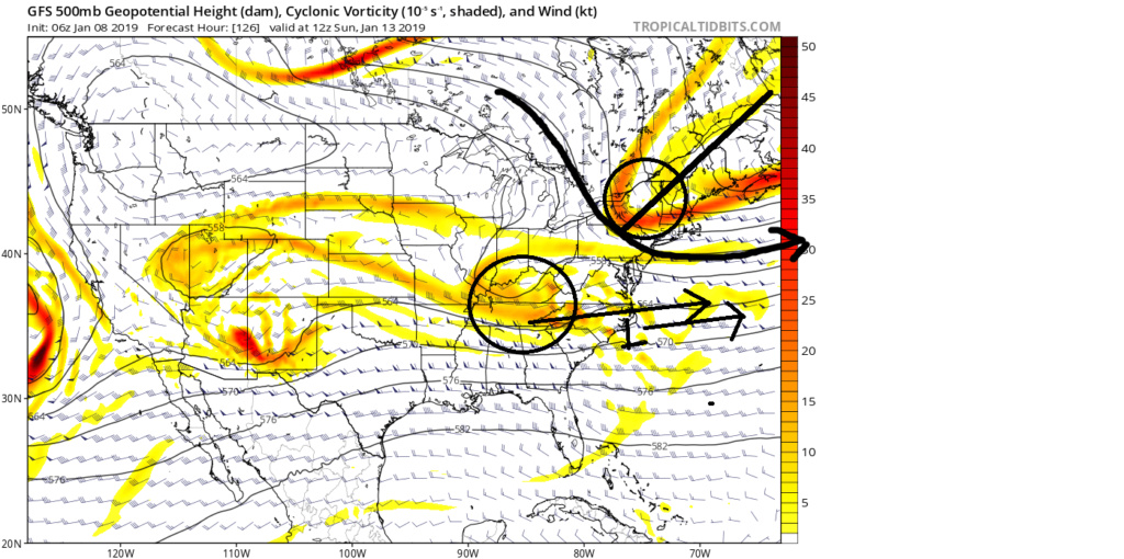
Update: I have to quote myself from the Tuesday morning write up because it summarized fairly well what we had to have happen for things to work out. I have highlighted the key points. Once again the Euro is King and had the right idea overall well before the GFS. This; however, should come as no surprise. For the images in the quote below regarding the GFS we really needed to have the S energy out ahead of the N energy to get a true storm to track far enough N to affect the area in a significant way.
Once it became clear that the N energy would remain ahead of the S energy the focus for me shifted to over running high ratio snow event that would preceded the main LP as has been high lighted over the past few days. With the GFS still jumping around quite a bit with some of he key features at 500mb I used the much more consistent Euro and focused on the more specific location and timing of the N trough, the strength of the S energy( how consolidated or strung out it is), and to a lesser extent the Energy on the N fringe of the PNA ridge(which plays a role in the result of the N trough). Below where the last several runs of the euro high lighting the 3 key components to watch. Up until last nights 00z the euro had slowly been trending slightly slower, and further N&W with the placement of the N trough and the S energy had trended a tad stronger and more consolidated. Remember the changes were subtle but the diff between 0-1" vs 3-5" of a light high ratio snow was apparent. Unfort as you can see by he last image below(00z Jan 10th) we are back to what looks more like 00z Jan 8th(first image) where the N Trough is back S into central VT/NH and no longer back west into the E GL and along the US/Ca border like 12z yesterday. The result is the boundary layer is draped over the LI sound/CT shore rather than up into central Mass area highlighted by the black line, and arrow pointing N just off our coast line.
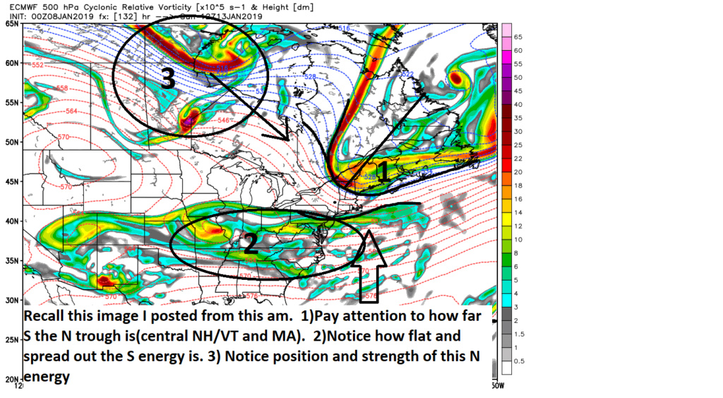
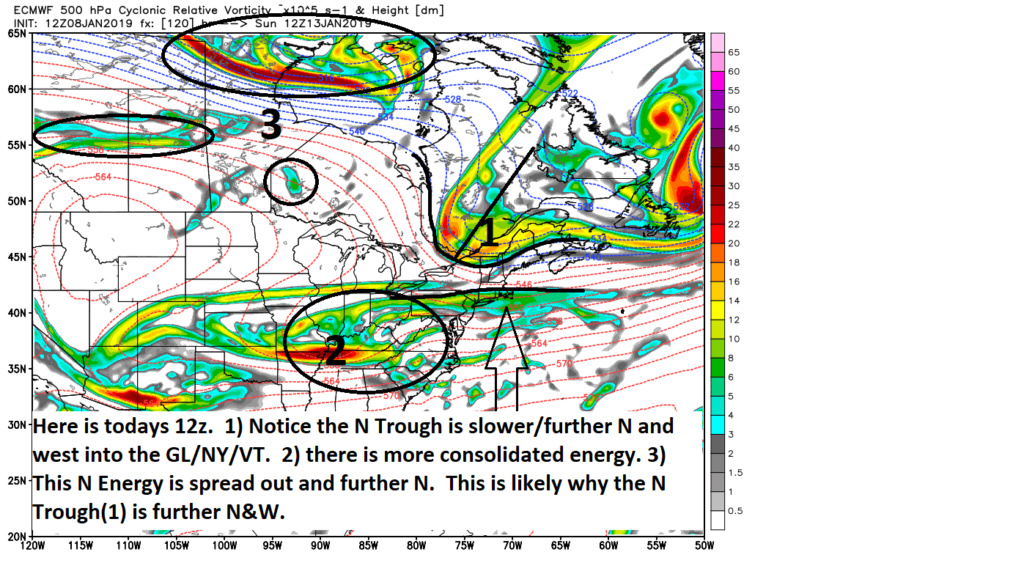
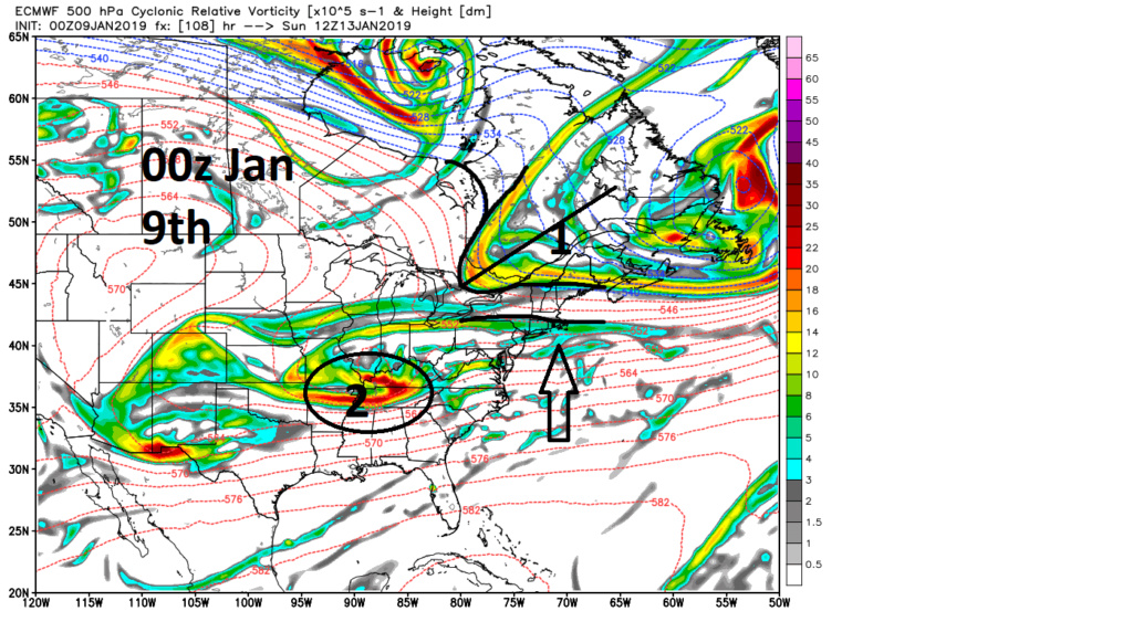
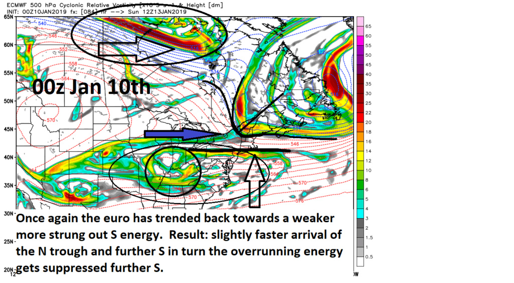
The euro has trended further N with the over running event for several runs in a row while last night it went back in the other direction. We still have 2 days to go so we will see if this is a blip and we tick back to the slightly further N&W with the N trough or if in the final hours we cont even more suppressed, which is possible. The result of this likely dicates how strung out or consolidated the S energy is. Low expectations leads to smaller disappointments.
A few more clicks in a similar fashion 1) even more consolidation of S energy 2) even slower and further N&W the N Trough and additional large positive changes at the surface are in order. HOWEVER, the same amount of tiny changes back in the other direction at 500mb and you get what the 00z Euro showed.
Final quote below: Tue Jan 08, 2019 7:17 am
sroc4 wrote:GFS 00z (still showing decent storm affecting coastal plain) vs 06z storm system OTS and suppressed.
Two main features to watch if you going to look at models. Surface is useless. 500 tells the story.
00z:
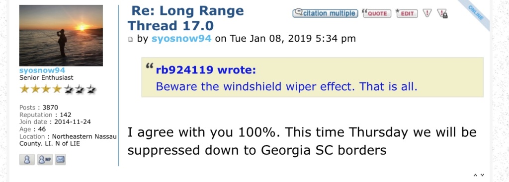
VS the 06z:
The Euro has been more consistent showing the N energy out ahead of the S energy AND has been more consistently showing the S energy more strung out vs consolidated when compared to the GFS. In Ray's write up he mentioned this as well. The strung out nature of the energy, if this is being modeled correctly by the euro, will make it very diff for the heights to raise out ahead of the system because it generates a weaker system overall. This combined with the N energy ahead of the S energy does not lend me to believe that we end up with a true snow storm...this time because the 500mb flow along the coast remains too progressive to bring the storm track N enough. While I certainly have not written anything off, esp some light snow possibly making it into parts of the area, a suppressed soln is def where I am leaning until I see the euro shift towards a more consolidated S energy and/or a slower N energy.
Once it became clear that the N energy would remain ahead of the S energy the focus for me shifted to over running high ratio snow event that would preceded the main LP as has been high lighted over the past few days. With the GFS still jumping around quite a bit with some of he key features at 500mb I used the much more consistent Euro and focused on the more specific location and timing of the N trough, the strength of the S energy( how consolidated or strung out it is), and to a lesser extent the Energy on the N fringe of the PNA ridge(which plays a role in the result of the N trough). Below where the last several runs of the euro high lighting the 3 key components to watch. Up until last nights 00z the euro had slowly been trending slightly slower, and further N&W with the placement of the N trough and the S energy had trended a tad stronger and more consolidated. Remember the changes were subtle but the diff between 0-1" vs 3-5" of a light high ratio snow was apparent. Unfort as you can see by he last image below(00z Jan 10th) we are back to what looks more like 00z Jan 8th(first image) where the N Trough is back S into central VT/NH and no longer back west into the E GL and along the US/Ca border like 12z yesterday. The result is the boundary layer is draped over the LI sound/CT shore rather than up into central Mass area highlighted by the black line, and arrow pointing N just off our coast line.


The euro has trended further N with the over running event for several runs in a row while last night it went back in the other direction. We still have 2 days to go so we will see if this is a blip and we tick back to the slightly further N&W with the N trough or if in the final hours we cont even more suppressed, which is possible. The result of this likely dicates how strung out or consolidated the S energy is. Low expectations leads to smaller disappointments.
A few more clicks in a similar fashion 1) even more consolidation of S energy 2) even slower and further N&W the N Trough and additional large positive changes at the surface are in order. HOWEVER, the same amount of tiny changes back in the other direction at 500mb and you get what the 00z Euro showed.
Final quote below: Tue Jan 08, 2019 7:17 am
sroc4 wrote:Do not get discouraged by the 13th system being suppressed. While it’s not entirely dead yet, IMHO it almost always looked to be a suppressed system so for me there wasn’t anything to get too worked up over nor disappointed over. While this set up and likely ultimate soln has very similar tendencies to the suppressed Dec 9th/10th storm, unlike that system behind it the pattern becomes ripe for the picking rather than headed to the above normal temp/cutter pattern that followed the Dec system.
I still firmly believe that when this winter is said and done many will grade it around a B. That means a big time come back given the last month. If you don’t want to buy it fine but keep it in the playpen thread. Any garbage in here will be deleted.
Last edited by sroc4 on Thu Jan 10, 2019 7:21 am; edited 1 time in total
sroc4- Admin

- Posts : 8354
Join date : 2013-01-07
 Re: JAN 12th-13th 2019 Snow threat
This storm is shaping up just as I started to suspect yesterday morning: A DC to AC Special. I still think we see some snow here but very light with SNJ getting accumulations. I remember as a kid walking to school one day in flurries with light snow coating the ground while the news reported on the 12-18” of snow falling heavily in Atlantic City. Not sure the South Jersey coast will do THAT well but it is the best place to be Sunday night to see something significant from this. I’ll keep hoping for that last minute shift north in the next 24-48 hours but for now looks like there will be shoveling at my shorehouse and sweeping at mine.
billg315- Advanced Forecaster - Mod

- Posts : 4483
Join date : 2015-01-24
 Re: JAN 12th-13th 2019 Snow threat
billg315 wrote:This storm is shaping up just as I started to suspect yesterday morning: A DC to AC Special. I still think we see some snow here but very light with SNJ getting accumulations. I remember as a kid walking to school one day in flurries with light snow coating the ground while the news reported on the 12-18” of snow falling heavily in Atlantic City. Not sure the South Jersey coast will do THAT well but it is the best place to be Sunday night to see something significant from this. I’ll keep hoping for that last minute shift north in the next 24-48 hours but for now looks like there will be shoveling at my shorehouse and sweeping at mine.
Bill keep hoping for that Sunday shift north, and also keep hoping for that Sunday night visit from Marissa Miller, and that Sunday night call from Sophia Vegara, and the Sunday afternoon visit from publishers clearinghouse to hand you your six foot long check for 10 million dollars, they all have about an equal chance of actually happening.

CPcantmeasuresnow- Wx Statistician Guru

- Posts : 7274
Reputation : 230
Join date : 2013-01-07
Age : 103
Location : Eastern Orange County, NY
 Re: JAN 12th-13th 2019 Snow threat
We have seen storms either suppressed or cut to our west. Its been that type of winter.
I thought this storm had a real chance - by far of all storms this winter at least - but it is not going to work out. Central NJ could still see a coating to 1 inch of high ratio snow, and parts of SNJ, including the shore, could see an inch or more depending on what happens with the coastal developing late Sunday.
But this will not be a widespread significant snowfall. Kudos to Ray for recognizing the pattern and calling for a suppressed storm.
_________________
_______________________________________________________________________________________________________
CLICK HERE to view NJ Strong Snowstorm Classifications
 Re: JAN 12th-13th 2019 Snow threat
CPcantmeasuresnow wrote:billg315 wrote:This storm is shaping up just as I started to suspect yesterday morning: A DC to AC Special. I still think we see some snow here but very light with SNJ getting accumulations. I remember as a kid walking to school one day in flurries with light snow coating the ground while the news reported on the 12-18” of snow falling heavily in Atlantic City. Not sure the South Jersey coast will do THAT well but it is the best place to be Sunday night to see something significant from this. I’ll keep hoping for that last minute shift north in the next 24-48 hours but for now looks like there will be shoveling at my shorehouse and sweeping at mine.
Bill keep hoping for that Sunday shift north, and also keep hoping for that Sunday night visit from Marissa Miller, and that Sunday night call from Sophia Vegara, and the Sunday afternoon visit from publishers clearinghouse to hand you your six foot long check for 10 million dollars, they all have about an equal chance of actually happening.
CP, while I agree those things are equally unlikely to happen . . . these ideas in my head will now make for a very exciting Saturday night sleep.

billg315- Advanced Forecaster - Mod

- Posts : 4483
Reputation : 185
Join date : 2015-01-24
Age : 50
Location : Flemington, NJ
 Re: JAN 12th-13th 2019 Snow threat
Frank_Wx wrote:We have seen storms either suppressed or cut to our west. Its been that type of winter.
I thought this storm had a real chance - by far of all storms this winter at least - but it is not going to work out. Central NJ could still see a coating to 1 inch of high ratio snow, and parts of SNJ, including the shore, could see an inch or more depending on what happens with the coastal developing late Sunday.
But this will not be a widespread significant snowfall. Kudos to Ray for recognizing the pattern and calling for a suppressed storm.
I didn't think it had a snowballs chance in hell, its that kind of year. I am over it. I look forward to the epic warmth that February has been bringing us lately.

mikeypizano- Pro Enthusiast

- Posts : 1118
Reputation : 66
Join date : 2017-01-05
Age : 35
Location : Wilkes-Barre/Scranton, PA
 Re: JAN 12th-13th 2019 Snow threat
Fact is, latest runs still looking good from about I-195 on south. Last runs verbatim approach Godzilla levels for some members of this board (big IF ratios are 15-25:1).
00z gfs run started...i'm still curious.
00z gfs run started...i'm still curious.
SENJsnowman- Senior Enthusiast

- Posts : 1189
Reputation : 61
Join date : 2017-01-06
Age : 51
Location : Bayville, NJ
 Re: JAN 12th-13th 2019 Snow threat
Actually, the facts according to the 12z GFS are what you'd expect. Not happening. The atmosphere just does not want to snow.
This run takes the totals away from MD and VA. Only above 4-5 inches at elevations.
This run takes the totals away from MD and VA. Only above 4-5 inches at elevations.
SENJsnowman- Senior Enthusiast

- Posts : 1189
Reputation : 61
Join date : 2017-01-06
Age : 51
Location : Bayville, NJ
 Re: JAN 12th-13th 2019 Snow threat
On second thought, we're still 4 full days away (Sun pm into Monday)...not even in the sr range yet, really. I'll stick it out for another day I guess. The wiper effect has been going crazy from C NJ on south and the good runs still have 8-10" easy (at 15:1) north thru Ocean Co.
SENJsnowman- Senior Enthusiast

- Posts : 1189
Reputation : 61
Join date : 2017-01-06
Age : 51
Location : Bayville, NJ
 Re: JAN 12th-13th 2019 Snow threat
SENJsnowman...I could see us Ocean County guys with 2 or 3 inches we should have a better idea by tomorrow am.
larryrock72- Posts : 140
Reputation : 5
Join date : 2017-01-03
Age : 52
Location : Barnegat, NJ
 Re: JAN 12th-13th 2019 Snow threat
larryrock72 wrote:SENJsnowman...I could see us Ocean County guys with 2 or 3 inches we should have a better idea by tomorrow am.
I hope the S and E crew does get that! At least somebody in our region will get some accumulating snow.Good luck guys and gals!

docstox12- Wx Statistician Guru

- Posts : 8530
Reputation : 222
Join date : 2013-01-07
Age : 73
Location : Monroe NY
 Re: JAN 12th-13th 2019 Snow threat
docstox12 wrote:larryrock72 wrote:SENJsnowman...I could see us Ocean County guys with 2 or 3 inches we should have a better idea by tomorrow am.
I hope the S and E crew does get that! At least somebody in our region will get some accumulating snow.Good luck guys and gals!
Classy statement. I agree. Hope they get something good out of it!!

Grselig- Senior Enthusiast

- Posts : 1408
Reputation : 140
Join date : 2013-03-04
Age : 54
Location : Wayne NJ
 Re: JAN 12th-13th 2019 Snow threat
That’s just doc being doc. And we have a shot down here for a mothra hit. GFS and CMC both showed 4-6” at 10:1 as recently as 00z. That’s a legitimate cause for at least a glimmer of hope.
My own personal SCI for Ocean county at 1-2”: 50%. At >3-4”: 20%
My own personal SCI for Ocean county at 1-2”: 50%. At >3-4”: 20%
SENJsnowman- Senior Enthusiast

- Posts : 1189
Reputation : 61
Join date : 2017-01-06
Age : 51
Location : Bayville, NJ
 Re: JAN 12th-13th 2019 Snow threat
SENJsnowman wrote:That’s just doc being doc. And we have a shot down here for a mothra hit. GFS and CMC both showed 4-6” at 10:1 as recently as 00z. That’s a legitimate cause for at least a glimmer of hope.
My own personal SCI for Ocean county at 1-2”: 50%. At >3-4”: 20%
I'm rooting for you. Good things do happen. I don't think I'm in the game, but hopefully you get a win this weekend and maybe next week we can manage something substantial.

Grselig- Senior Enthusiast

- Posts : 1408
Reputation : 140
Join date : 2013-03-04
Age : 54
Location : Wayne NJ
 Re: JAN 12th-13th 2019 Snow threat
I would love to have an area wide, from the S and E crew and LI crew, out to west to Aresian and rb, and up north to Hyde 20 incher plus so this board lights up like a Christmas tree with fun snowstorm posts.

docstox12- Wx Statistician Guru

- Posts : 8530
Reputation : 222
Join date : 2013-01-07
Age : 73
Location : Monroe NY
 Re: JAN 12th-13th 2019 Snow threat
docstox12 wrote:I would love to have an area wide, from the S and E crew and LI crew, out to west to Aresian and rb, and up north to Hyde 20 incher plus so this board lights up like a Christmas tree with fun snowstorm posts.
That would be great indeed - March is when these occur.
Shut the board down until then and close this threat its done - the PV Lobe shreds out the system and then presses hard rb nailed it

_________________
Mugs
AKA:King: Snow Weenie
Self Proclaimed
WINTER 2014-15 : 55.12" +.02 for 6 coatings (avg. 35")
WINTER 2015-16 Total - 29.8" (Avg 35")
WINTER 2016-17 : 39.5" so far

amugs- Advanced Forecaster - Mod

- Posts : 15095
Reputation : 213
Join date : 2013-01-07
Age : 54
Location : Hillsdale,NJ
 Re: JAN 12th-13th 2019 Snow threat
Heard that Mugs! Time to go ‘bleed’ a while...
SENJsnowman- Senior Enthusiast

- Posts : 1189
Reputation : 61
Join date : 2017-01-06
Age : 51
Location : Bayville, NJ
 Re: JAN 12th-13th 2019 Snow threat
amugs wrote:docstox12 wrote:I would love to have an area wide, from the S and E crew and LI crew, out to west to Aresian and rb, and up north to Hyde 20 incher plus so this board lights up like a Christmas tree with fun snowstorm posts.
That would be great indeed - March is when these occur.
Shut the board down until then and close this threat its done - the PV Lobe shreds out the system and then presses hard rb nailed it
Credit is due rb he was steadfast in downplaying this one days ago.

docstox12- Wx Statistician Guru

- Posts : 8530
Reputation : 222
Join date : 2013-01-07
Age : 73
Location : Monroe NY
 Re: JAN 12th-13th 2019 Snow threat
Would we have had yet another cutter and 40+ degree temperatures w/out the Northern stream interference? Not sure I could have taken another 1" rain and 42 degrees.
heehaw453- Advanced Forecaster

- Posts : 3906
Reputation : 86
Join date : 2014-01-20
Location : Bedminster Township, PA Elevation 600' ASL
 Re: JAN 12th-13th 2019 Snow threat
Yea doc Rb was on this! But lets hope he is right on what's to come, he has been very high and very confident, so hope is there.
jimv45- Senior Enthusiast

- Posts : 1168
Reputation : 36
Join date : 2013-09-20
Location : Hopewell jct.
 Re: JAN 12th-13th 2019 Snow threat
What a surprise kudos to rb but I don't even really check in much anymore cuz we aren't going to see another snowstorm I'm pretty sure. Nov. Was it. See you all in the spring. Which by the way after this next warm up will be less than 2 months away. Really I consider march to be when spring usually starts.

jmanley32- Senior Enthusiast

- Posts : 20535
Reputation : 108
Join date : 2013-12-12
Age : 43
Location : Yonkers, NY
 Re: JAN 12th-13th 2019 Snow threat
Hilarious local weather actually saying possibly a inch or two NYC area. What are they on?

jmanley32- Senior Enthusiast

- Posts : 20535
Reputation : 108
Join date : 2013-12-12
Age : 43
Location : Yonkers, NY
 Re: JAN 12th-13th 2019 Snow threat
jmanley32 wrote:What a surprise kudos to rb but I don't even really check in much anymore cuz we aren't going to see another snowstorm I'm pretty sure. Nov. Was it. See you all in the spring. Which by the way after this next warm up will be less than 2 months away. Really I consider march to be when spring usually starts.
3 of the last 4 years there's been more snow in NYC in March than in any of the other winter months.
You consider that spring?

CPcantmeasuresnow- Wx Statistician Guru

- Posts : 7274
Reputation : 230
Join date : 2013-01-07
Age : 103
Location : Eastern Orange County, NY
 Re: JAN 12th-13th 2019 Snow threat
I think the GFS shows several hours of over-running snow ahead of the wave getting to and moving off the coast. They’re probably counting on that and with the very cold temps this weekend a high-ratio snow. I’m skeptical and still think a coating to an inch is the best we’ll do. But that’s got to be what they’re looking at.jmanley32 wrote:Hilarious local weather actually saying possibly a inch or two NYC area. What are they on?

billg315- Advanced Forecaster - Mod

- Posts : 4483
Reputation : 185
Join date : 2015-01-24
Age : 50
Location : Flemington, NJ
 Re: JAN 12th-13th 2019 Snow threat
The silence is deafening, and sums up everything.

CPcantmeasuresnow- Wx Statistician Guru

- Posts : 7274
Reputation : 230
Join date : 2013-01-07
Age : 103
Location : Eastern Orange County, NY
 Re: JAN 12th-13th 2019 Snow threat
My best guess for this system is anywhere north of approximately D.C./Baltimore latiude will see a dusting to 2". See the Long Range Thread for better news 
rb924119- Meteorologist

- Posts : 6931
Reputation : 194
Join date : 2013-02-06
Age : 32
Location : Greentown, Pa
Page 4 of 4 •  1, 2, 3, 4
Permissions in this forum:
You cannot reply to topics in this forum|
|
|

 Home
Home


