JANUARY 19TH-20TH STORM THREAT
+44
gigs68
ndionyssiou
docstox12
Taffy
HectorO
SENJsnowman
jake732
SoulSingMG
Smitty623
GreyBeard
jimv45
mmanisca
DAYBLAZER
emokid51783
Irish
Grselig
lglickman1
oldtimer
Dunnzoo
Radz
CPcantmeasuresnow
Joe Snow
Frank_Wx
Sanchize06
dkodgis
Vinnydula
snowlover 12345
Scullybutcher
nutleyblizzard
billg315
aiannone
heehaw453
mwilli5783
weatherwatchermom
jmanley32
skinsfan1177
algae888
hyde345
Carvin
frank 638
rb924119
bobjohnsonforthehall
amugs
sroc4
48 posters
Page 9 of 21
Page 9 of 21 •  1 ... 6 ... 8, 9, 10 ... 15 ... 21
 Re: JANUARY 19TH-20TH STORM THREAT
hyde345 wrote:rb924119 wrote:I actually think the 15:1 map is more representative of the overall distribution. Whomever is immediately on the cold side of the thermal gradient aloft is going to be absolutely RIPPING, relative to those further north and west. Also, ratios will still be approximately 15:1 there, if not even a bit higher based on my earlier analysis. Secondly, the incredible vertical motion is undoubtedly going to work to offset the northward protrusion of the warm tongue for seemingly borderline locations. For example, anywhere the current thermal profile suggests a particular point reaches 0-1C aloft, I think will actually end up below 0C and snowing via intense dynamics. This also why I like one more southward correction from the consensus, but time will tell. I will say, though, that having the Euro, UK, and NAM seemingly aligned and still trending favorable is a tremendous positive (knocks on wood).
Ray, things are looking pretty good north of 84 in Dutchess. Im 10 miles north of Poughkeepsie and hoping freezing rain stays south. I just hate the ice. Are you in Fishkill?
I will very likely be going home to PA for this one, so no, I won’t be in Fishkill this time
rb924119- Meteorologist

- Posts : 6889
Join date : 2013-02-06
 Re: JANUARY 19TH-20TH STORM THREAT
Anyone know for the city if we going to have snow to rain then back to snow or snow and sleet and freezing rain situation thanks
frank 638- Senior Enthusiast

- Posts : 2824
Join date : 2016-01-01
 Re: JANUARY 19TH-20TH STORM THREAT
TheAresian wrote:I mean 12" is a reasonable total, but with the cold temps forecasted for my area the ratio bump jumps the total up to 18-24". That would make it the biggest or 2nd biggest snowfall since the Superstorm of 93. Does this system really have that much potential?
I think you end up more in the 10-16/12-18” range personally (see my next post), but yes, it does. This storm, wherever it snows, and ESPECIALLY just north of the mix line, will produce some pretty awesome PROLONGED snowfall rates. Sure, it will be in and out in 12-16 hours, but you’ll average anywhere from 1-3”/hour for probably 75% of the storm’s duration. Given the ratios, and even more importantly, crystal formation habits favoring dendrites and stellar plates, which rapidly accumulate, this is actually well within reason. I just think that maximum band is further southeast of you, again, see my next post
rb924119- Meteorologist

- Posts : 6889
Reputation : 194
Join date : 2013-02-06
Age : 32
Location : Greentown, Pa
 Re: JANUARY 19TH-20TH STORM THREAT

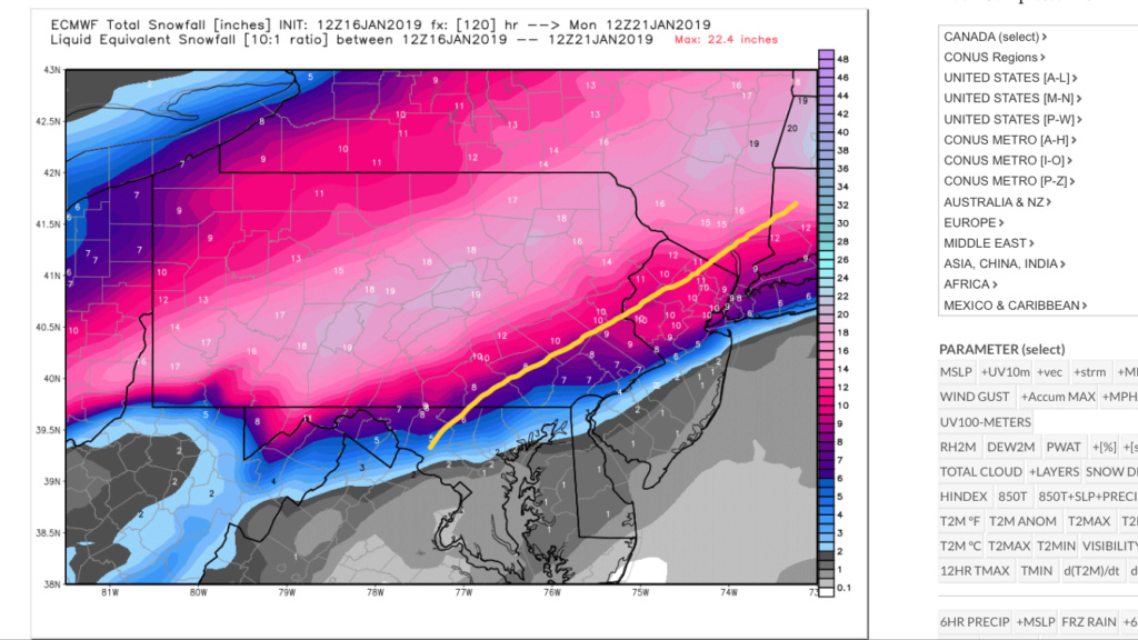
Anywhere south of the yellow line (as an approximation), I think the 10:1 map (which is annotated) looks quite reasonable for numbers. North of there, I much prefer the look of the 15:1 distribution, although this whole thing shifted another 25-40 miles south. Again, this is just a general idea of what I think seems most reasonable right now.
rb924119- Meteorologist

- Posts : 6889
Reputation : 194
Join date : 2013-02-06
Age : 32
Location : Greentown, Pa
 Re: JANUARY 19TH-20TH STORM THREAT
algae888 wrote:New York City on the Euro never gets above 32 degrees for the entire storm in the twenties anywhere north of there. Newark highest temperature is 30 during the storm. We still have to remember the mid-levels are going to warm because this is a southern stream system so even though temps will be cold enough to support snow it will not be an all-out snowfall for many of us probably a 30 mile radius north and west of the city. you have to get into CP and Doc land for it to have a chance to stay all snow even there can mix. Verbatim on the euro is five to seven in for New York City followed by 1.8 in of either sleet or freezing rain followed by 1 to 3 in of snow on the back end I don't ever recall a storm like this if this were to happen
WELCOME TO THE NEW SOLAR MINIMUM!!!!!
_________________
Mugs
AKA:King: Snow Weenie
Self Proclaimed
WINTER 2014-15 : 55.12" +.02 for 6 coatings (avg. 35")
WINTER 2015-16 Total - 29.8" (Avg 35")
WINTER 2016-17 : 39.5" so far

amugs- Advanced Forecaster - Mod

- Posts : 15093
Reputation : 213
Join date : 2013-01-07
Age : 54
Location : Hillsdale,NJ
 Re: JANUARY 19TH-20TH STORM THREAT
amugs wrote:rb924119 wrote:I actually think the 15:1 map is more representative of the overall distribution. Whomever is immediately on the cold side of the thermal gradient aloft is going to be absolutely RIPPING, relative to those further north and west. Also, ratios will still be approximately 15:1 there, if not even a bit higher based on my earlier analysis. Secondly, the incredible vertical motion is undoubtedly going to work to offset the northward protrusion of the warm tongue for seemingly borderline locations. For example, anywhere the current thermal profile suggests a particular point reaches 0-1C aloft, I think will actually end up below 0C and snowing via intense dynamics. This also why I like one more southward correction from the consensus, but time will tell. I will say, though, that having the Euro, UK, and NAM seemingly aligned and still trending favorable is a tremendous positive (knocks on wood).
No kidding aside you made these lat two storms call after the Nov debacle LOL! - Great come back kid!
Alex you beat me to the punch on the ice maps - I had to teach a few kids a few things about ................C........A.................D......


Crippling scenario. Need a few more ticks over teh next 24 hours and then..............HOLD!!
Thanks, mugsy, but I’m not counting any chickens yet lol
rb924119- Meteorologist

- Posts : 6889
Reputation : 194
Join date : 2013-02-06
Age : 32
Location : Greentown, Pa
 Re: JANUARY 19TH-20TH STORM THREAT
Lawd have mercery EPS
_________________
"In weather and in life, there's no winning and losing; there's only winning and learning."
WINTER 2012/2013 TOTALS 43.65"WINTER 2017/2018 TOTALS 62.85" WINTER 2022/2023 TOTALS 4.9"
WINTER 2013/2014 TOTALS 64.85"WINTER 2018/2019 TOTALS 14.25" WINTER 2023/2024 TOTALS 13.1"
WINTER 2014/2015 TOTALS 71.20"WINTER 2019/2020 TOTALS 6.35"
WINTER 2015/2016 TOTALS 35.00"WINTER 2020/2021 TOTALS 37.75"
WINTER 2016/2017 TOTALS 42.25"WINTER 2021/2022 TOTALS 31.65"

sroc4- Admin

- Posts : 8331
Reputation : 301
Join date : 2013-01-07
Location : Wading River, LI
 Re: JANUARY 19TH-20TH STORM THREAT
_________________
"In weather and in life, there's no winning and losing; there's only winning and learning."
WINTER 2012/2013 TOTALS 43.65"WINTER 2017/2018 TOTALS 62.85" WINTER 2022/2023 TOTALS 4.9"
WINTER 2013/2014 TOTALS 64.85"WINTER 2018/2019 TOTALS 14.25" WINTER 2023/2024 TOTALS 13.1"
WINTER 2014/2015 TOTALS 71.20"WINTER 2019/2020 TOTALS 6.35"
WINTER 2015/2016 TOTALS 35.00"WINTER 2020/2021 TOTALS 37.75"
WINTER 2016/2017 TOTALS 42.25"WINTER 2021/2022 TOTALS 31.65"

sroc4- Admin

- Posts : 8331
Reputation : 301
Join date : 2013-01-07
Location : Wading River, LI
 Re: JANUARY 19TH-20TH STORM THREAT
I'm not excited at all for this storm in my area looks like rain ugh

skinsfan1177- Senior Enthusiast

- Posts : 4485
Reputation : 35
Join date : 2013-01-07
Age : 46
Location : Point Pleasant Boro
 Re: JANUARY 19TH-20TH STORM THREAT
rb924119 wrote:
Anywhere south of the yellow line (as an approximation), I think the 10:1 map (which is annotated) looks quite reasonable for numbers. North of there, I much prefer the look of the 15:1 distribution, although this whole thing shifted another 25-40 miles south. Again, this is just a general idea of what I think seems most reasonable right now.
What about if you are directly UNDER the line?
I kid, I know it's an approximation as you said. But you literally drew the line right over my backyard here in Southern Sussex NJ.

DAYBLAZER- Posts : 228
Reputation : 20
Join date : 2017-03-12
Location : Hopatcong, NJ Sussex County
 Re: JANUARY 19TH-20TH STORM THREAT
_________________
Mugs
AKA:King: Snow Weenie
Self Proclaimed
WINTER 2014-15 : 55.12" +.02 for 6 coatings (avg. 35")
WINTER 2015-16 Total - 29.8" (Avg 35")
WINTER 2016-17 : 39.5" so far

amugs- Advanced Forecaster - Mod

- Posts : 15093
Reputation : 213
Join date : 2013-01-07
Age : 54
Location : Hillsdale,NJ
 Re: JANUARY 19TH-20TH STORM THREAT
_________________
Mugs
AKA:King: Snow Weenie
Self Proclaimed
WINTER 2014-15 : 55.12" +.02 for 6 coatings (avg. 35")
WINTER 2015-16 Total - 29.8" (Avg 35")
WINTER 2016-17 : 39.5" so far

amugs- Advanced Forecaster - Mod

- Posts : 15093
Reputation : 213
Join date : 2013-01-07
Age : 54
Location : Hillsdale,NJ
 Re: JANUARY 19TH-20TH STORM THREAT
DAYBLAZER wrote:rb924119 wrote:
Anywhere south of the yellow line (as an approximation), I think the 10:1 map (which is annotated) looks quite reasonable for numbers. North of there, I much prefer the look of the 15:1 distribution, although this whole thing shifted another 25-40 miles south. Again, this is just a general idea of what I think seems most reasonable right now.
What about if you are directly UNDER the line?
I kid, I know it's an approximation as you said. But you literally drew the line right over my backyard here in Southern Sussex NJ.
Lmao oops
You have to blend the two (feather them together, like a haircut haha), splice them. Verbatim, you’d be between the two, so 10-15”. REMEMBER THATS AN APPROXIMATION. Also, if we get the final shift, you’d be closer to the 15” than the 10”, again, if taken verbatim. Proceed with caution, as this is not an official forecast haha
rb924119- Meteorologist

- Posts : 6889
Reputation : 194
Join date : 2013-02-06
Age : 32
Location : Greentown, Pa
 Re: JANUARY 19TH-20TH STORM THREAT
Last edited by jmanley32 on Wed Jan 16, 2019 2:51 pm; edited 1 time in total

jmanley32- Senior Enthusiast

- Posts : 20513
Reputation : 108
Join date : 2013-12-12
Age : 42
Location : Yonkers, NY
 Re: JANUARY 19TH-20TH STORM THREAT
SROC - lots of S leaners on that good to see.
Lots of time still peeps so we need a few more corrections in the next 24-36 hours and then we can hone in on this but the team is marching down teh field and the goal line is about 35 yards away at this point!
Lots of time still peeps so we need a few more corrections in the next 24-36 hours and then we can hone in on this but the team is marching down teh field and the goal line is about 35 yards away at this point!
_________________
Mugs
AKA:King: Snow Weenie
Self Proclaimed
WINTER 2014-15 : 55.12" +.02 for 6 coatings (avg. 35")
WINTER 2015-16 Total - 29.8" (Avg 35")
WINTER 2016-17 : 39.5" so far

amugs- Advanced Forecaster - Mod

- Posts : 15093
Reputation : 213
Join date : 2013-01-07
Age : 54
Location : Hillsdale,NJ
 Re: JANUARY 19TH-20TH STORM THREAT
amugs wrote:SROC - lots of S leaners on that good to see.
Lots of time still peeps so we need a few more corrections in the next 24-36 hours and then we can hone in on this but the team is marching down teh field and the goal line is about 35 yards away at this point!
Just hope we're not the NY Giants where Eli throws a pick six on the next play.

bobjohnsonforthehall- Posts : 311
Reputation : 19
Join date : 2016-10-02
Location : Flemington NJ
 Re: JANUARY 19TH-20TH STORM THREAT
They are most likely but as yuo dais its an ensemble for gods sake not an OP - 6" is a good amount and I don't see EPS having Ice accretion maps. Better than what you had the last 8 weeks & last weekend right? Take it and run to the bank there are more in the pipeline to come.
_________________
Mugs
AKA:King: Snow Weenie
Self Proclaimed
WINTER 2014-15 : 55.12" +.02 for 6 coatings (avg. 35")
WINTER 2015-16 Total - 29.8" (Avg 35")
WINTER 2016-17 : 39.5" so far

amugs- Advanced Forecaster - Mod

- Posts : 15093
Reputation : 213
Join date : 2013-01-07
Age : 54
Location : Hillsdale,NJ
 Re: JANUARY 19TH-20TH STORM THREAT
bobjohnsonforthehall wrote:amugs wrote:SROC - lots of S leaners on that good to see.
Lots of time still peeps so we need a few more corrections in the next 24-36 hours and then we can hone in on this but the team is marching down teh field and the goal line is about 35 yards away at this point!
Just hope we're not the NY Giants where Eli throws a pick six on the next play.
This statement (and worry) is truer than words can express ahahahahahahaha literally lmao right now ahahaha
rb924119- Meteorologist

- Posts : 6889
Reputation : 194
Join date : 2013-02-06
Age : 32
Location : Greentown, Pa
 Re: JANUARY 19TH-20TH STORM THREAT
barkley is moving the system down the field,even obj is blocking..lol
mwilli5783- Posts : 146
Reputation : 9
Join date : 2013-01-23
Age : 69
Location : hempstead n.y
 Re: JANUARY 19TH-20TH STORM THREAT
Voice of Reason coming:
Honestly I would not take any of today verbatim in any way shape or form. We still have to first nail down storm track which is still not a consensus yet. The basic trends have been further S&E, but the GFS has remained on the NW side of the consensus. It would not be unheard of to see the models shift back NW a little before settling onto the final track.
Once the track is better understood then we can focus our attention to the thermal profiles. This could be the hardest part of the forecast as there will be a very tight gradient. You may not have to travel all that far as the crow flies to see the difference between Godzilla and oogatz. Keep in mind lower res models like the GFS will have a tough time with some of the thermal detailks as this will be a dynamic system as it approaches so models like euro and the sr hi res models will likely do better in guiding the forecast going forward. Even then there will still be busted forecasts both on the high end and the low end with this type of dynamic system. It happens every time and is unavoidable.
So buckle up folks because the next 2days is going to be a wild ride.


_________________
"In weather and in life, there's no winning and losing; there's only winning and learning."
WINTER 2012/2013 TOTALS 43.65"WINTER 2017/2018 TOTALS 62.85" WINTER 2022/2023 TOTALS 4.9"
WINTER 2013/2014 TOTALS 64.85"WINTER 2018/2019 TOTALS 14.25" WINTER 2023/2024 TOTALS 13.1"
WINTER 2014/2015 TOTALS 71.20"WINTER 2019/2020 TOTALS 6.35"
WINTER 2015/2016 TOTALS 35.00"WINTER 2020/2021 TOTALS 37.75"
WINTER 2016/2017 TOTALS 42.25"WINTER 2021/2022 TOTALS 31.65"

sroc4- Admin

- Posts : 8331
Reputation : 301
Join date : 2013-01-07
Location : Wading River, LI
 Re: JANUARY 19TH-20TH STORM THREAT
amugs wrote:
They are most likely but as yuo dais its an ensemble for gods sake not an OP - 6" is a good amount and I don't see EPS having Ice accretion maps. Better than what you had the last 8 weeks & last weekend right? Take it and run to the bank there are more in the pipeline to come.
ABSOLUTELY ZERO CHANCE that if these EPS lp placements verified that the coast would only be 4-8” with this kind of cold. No way.
Guest- Guest
 Re: JANUARY 19TH-20TH STORM THREAT
sroc4 wrote:Voice of Reason coming:
Honestly I would not take any of today verbatim in any way shape or form. We still have to first nail down storm track which is still not a consensus yet. The basic trends have been further S&E, but the GFS has remained on the NW side of the consensus. It would not be unheard of to see the models shift back NW a little before settling onto the final track.
Once the track is better understood then we can focus our attention to the thermal profiles. This could be the hardest part of the forecast as there will be a very tight gradient. You may not have to travel all that far as the crow flies to see the difference between Godzilla and oogatz. Keep in mind lower res models like the GFS will have a tough time with some of the thermal detailks as this will be a dynamic system as it approaches so models like euro and the sr hi res models will likely do better in guiding the forecast going forward. Even then there will still be busted forecasts both on the high end and the low end with this type of dynamic system. It happens every time and is unavoidable.
So buckle up folks because the next 2days is going to be a wild ride.
Ok..........daddddddd
rb924119- Meteorologist

- Posts : 6889
Reputation : 194
Join date : 2013-02-06
Age : 32
Location : Greentown, Pa
 Re: JANUARY 19TH-20TH STORM THREAT
Sroc Thank you for your Voice of Reason
oldtimer- Senior Enthusiast

- Posts : 1103
Reputation : 14
Join date : 2013-01-16
Age : 78
Location : Port Jefferson Station Suffolk County
 Re: JANUARY 19TH-20TH STORM THREAT
bobjohnsonforthehall wrote:amugs wrote:SROC - lots of S leaners on that good to see.
Lots of time still peeps so we need a few more corrections in the next 24-36 hours and then we can hone in on this but the team is marching down teh field and the goal line is about 35 yards away at this point!
Just hope we're not the NY Giants where Eli throws a pick six on the next play.
The man has also produced 2 Super Bowls and some clutch 2 minute victories. I’m hoping it’s Eli with a Line in his prime!

Grselig- Senior Enthusiast

- Posts : 1408
Reputation : 140
Join date : 2013-03-04
Age : 54
Location : Wayne NJ
 Re: JANUARY 19TH-20TH STORM THREAT
So Ocean County can really only see 1-2”? With it going to be that cold is 1-2” really all we see?
Sent from Topic'it App
Sent from Topic'it App
Smitty623- Posts : 22
Reputation : 4
Join date : 2018-01-02
 Re: JANUARY 19TH-20TH STORM THREAT
FWIW the latest SREFs look like the UKMET/Euro/NAM. That’s a good sign at this range. VERY GOOD SIGN.
rb924119- Meteorologist

- Posts : 6889
Reputation : 194
Join date : 2013-02-06
Age : 32
Location : Greentown, Pa
Page 9 of 21 •  1 ... 6 ... 8, 9, 10 ... 15 ... 21
Page 9 of 21
Permissions in this forum:
You cannot reply to topics in this forum|
|
|

 Home
Home

