JANUARY 19TH-20TH STORM THREAT
+44
gigs68
ndionyssiou
docstox12
Taffy
HectorO
SENJsnowman
jake732
SoulSingMG
Smitty623
GreyBeard
jimv45
mmanisca
DAYBLAZER
emokid51783
Irish
Grselig
lglickman1
oldtimer
Dunnzoo
Radz
CPcantmeasuresnow
Joe Snow
Frank_Wx
Sanchize06
dkodgis
Vinnydula
snowlover 12345
Scullybutcher
nutleyblizzard
billg315
aiannone
heehaw453
mwilli5783
weatherwatchermom
jmanley32
skinsfan1177
algae888
hyde345
Carvin
frank 638
rb924119
bobjohnsonforthehall
amugs
sroc4
48 posters
Page 1 of 21
Page 1 of 21 • 1, 2, 3 ... 11 ... 21 
 JANUARY 19TH-20TH STORM THREAT
First image is showing where the N energy is as well as the southern energy. As you can see our system is still way out over the Pac Ocean, the energy of which doesn't come ashore for about 36-48hrs or so. Notice where the N energy is located. It still has to journey even further N before rounding the N aspect of the TPV before beginning its journey into central Canada by hr 84 indicated by the yellow x's over the black line.

Next Id like to point out that we are still 4 days away and we currently still have changes occurring at H5 from model to model as well as within individual models meaning there is still plenty of time for a trend to cont both favorably as well as unfavorably. Below is simply the diff between 00z Euro and the most recent 12z. I will say three things. First, one run does not make a trend; however, the Ukie, while likely over correcting S&E might be onto something. Second, I do not believe that what I saw at H5 on the 12z Euro matches the surface at all so while we are seeing shifts at H5 you must take the surface with a large grain of salt as they often take time to catch onto the changes aloft. The third point I will make below, so look at the image comparisons Ive illustrated below until you come to my third point.
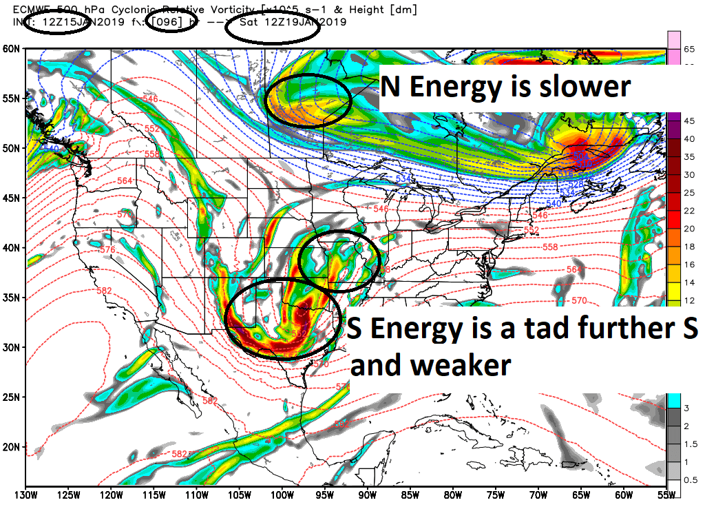
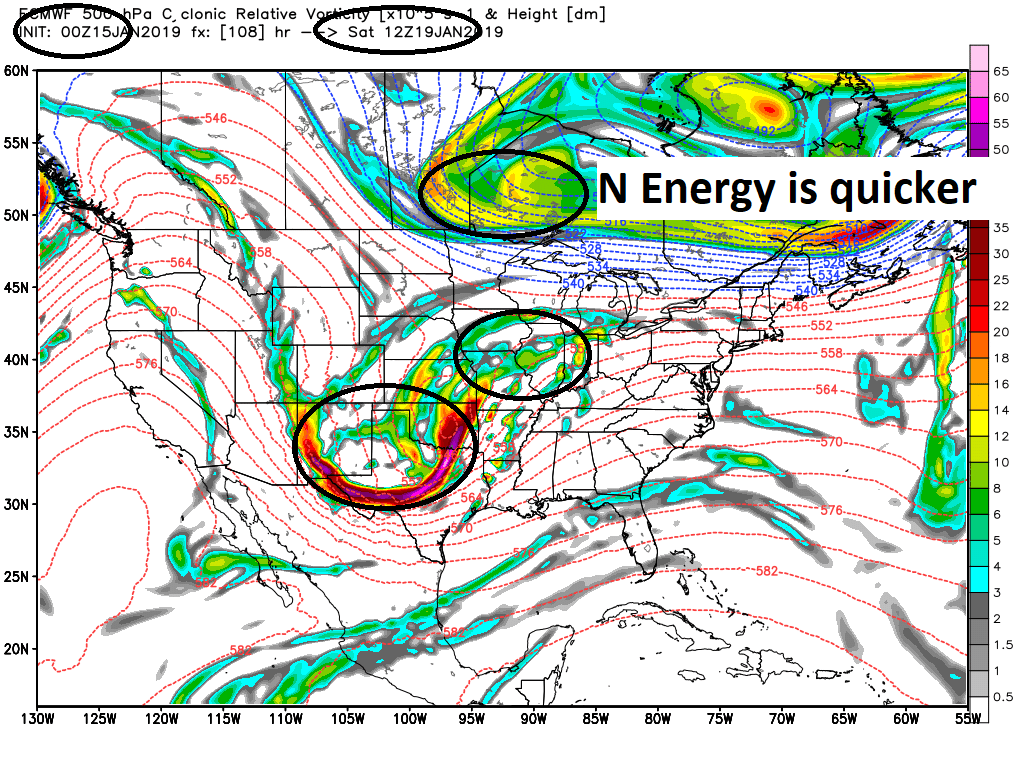
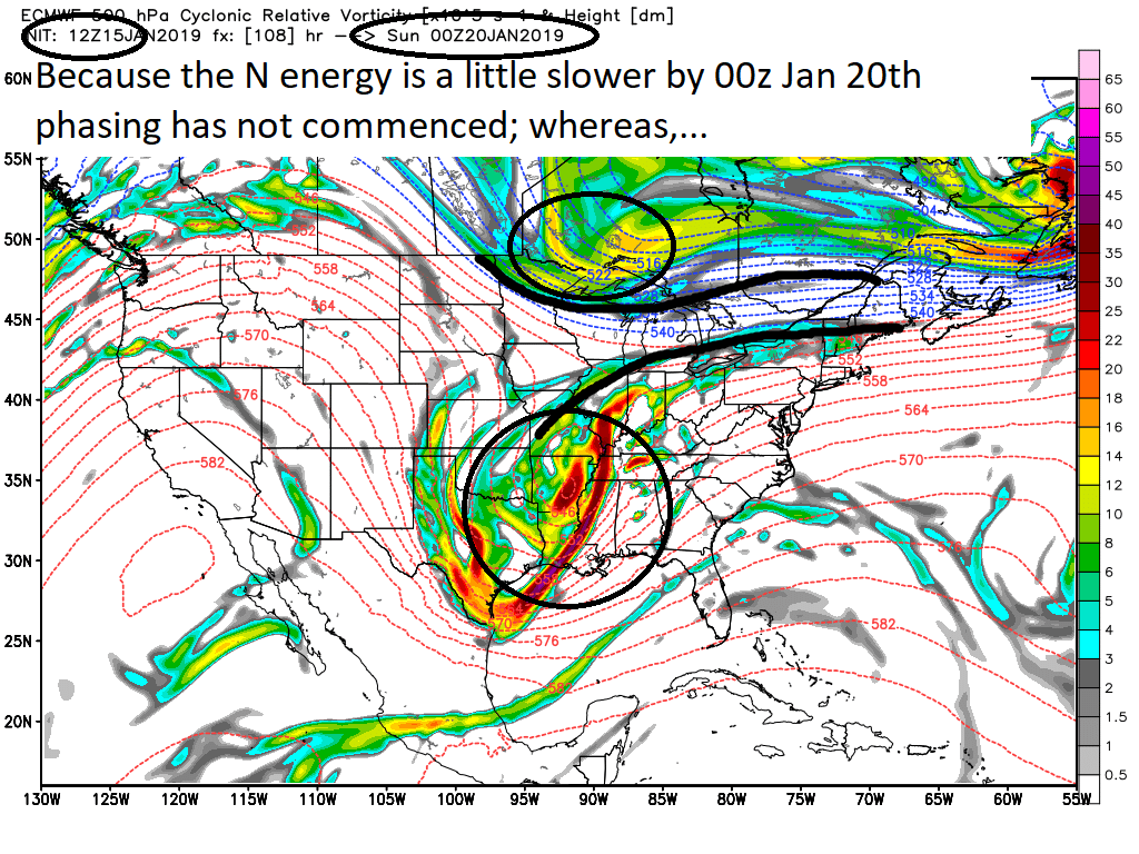
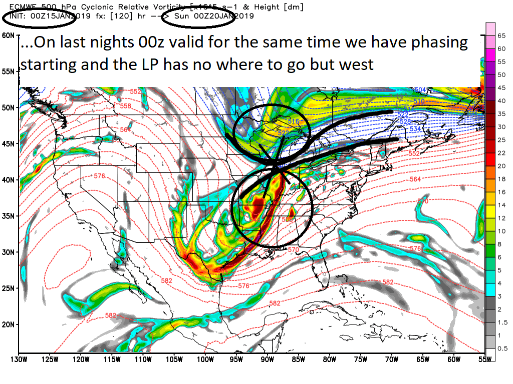
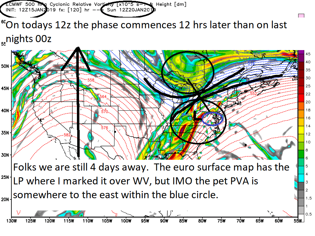
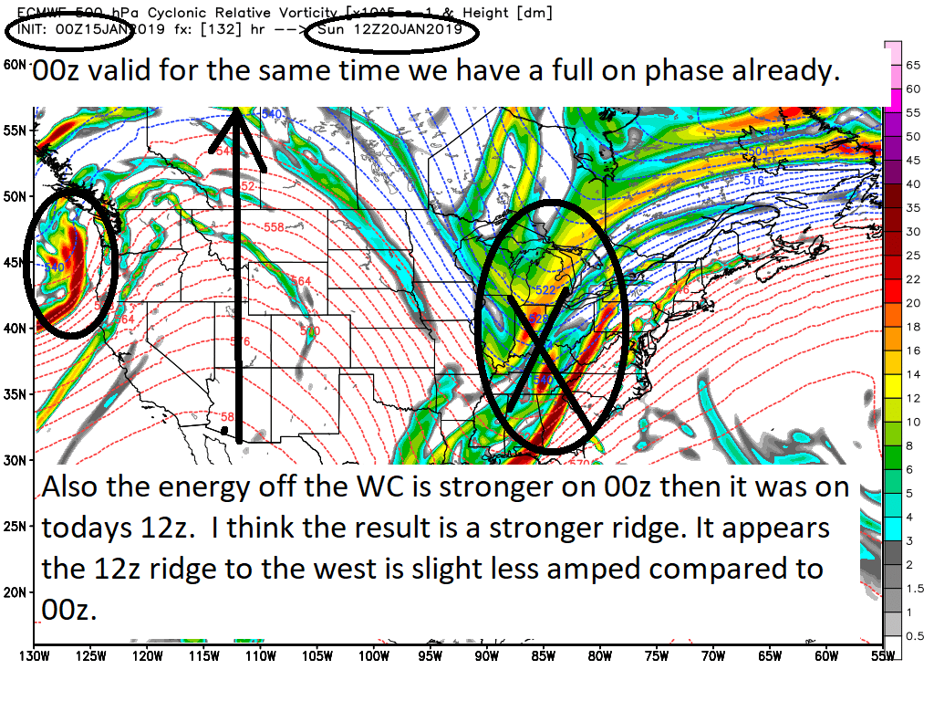
So my third point is that the changes aloft are a diff of only 12hrs in the timing/arrival of the N energy. IF we cont to see a mere 12 hr delay in the arrival of the N vort(esp this), and/or weaker S energy, and/or a further S track to the S energy; even the coastal plain COULD be in the game for moderate to significant snowfall, both front end and back end. Again one run does not make a trend, but there is some support from Ukie, and GEFS and there is still 4days away. I am not giving up just yet and you shouldn't either. The back end snow possibility for the coastal plain is real. As Rb has mentioned there is a very steep temp gradient such that if the wave of LP passes far enough S&E (likely needs to be S of LI somewhere) while we may start as snow and change to rain, if the phase is right and the track is right there could be a very quick burst of heavy snowfall on the back end.
Could it be a trend weaker with the PNA ridge might actually help us and be what we want?? It slows the speed of the northern vort into the conus; therefore, delays the phase for us. Syo/Jimmy I just read your last comment on the LR thread and I think your hitting the nail on the head.

Next Id like to point out that we are still 4 days away and we currently still have changes occurring at H5 from model to model as well as within individual models meaning there is still plenty of time for a trend to cont both favorably as well as unfavorably. Below is simply the diff between 00z Euro and the most recent 12z. I will say three things. First, one run does not make a trend; however, the Ukie, while likely over correcting S&E might be onto something. Second, I do not believe that what I saw at H5 on the 12z Euro matches the surface at all so while we are seeing shifts at H5 you must take the surface with a large grain of salt as they often take time to catch onto the changes aloft. The third point I will make below, so look at the image comparisons Ive illustrated below until you come to my third point.


So my third point is that the changes aloft are a diff of only 12hrs in the timing/arrival of the N energy. IF we cont to see a mere 12 hr delay in the arrival of the N vort(esp this), and/or weaker S energy, and/or a further S track to the S energy; even the coastal plain COULD be in the game for moderate to significant snowfall, both front end and back end. Again one run does not make a trend, but there is some support from Ukie, and GEFS and there is still 4days away. I am not giving up just yet and you shouldn't either. The back end snow possibility for the coastal plain is real. As Rb has mentioned there is a very steep temp gradient such that if the wave of LP passes far enough S&E (likely needs to be S of LI somewhere) while we may start as snow and change to rain, if the phase is right and the track is right there could be a very quick burst of heavy snowfall on the back end.
Could it be a trend weaker with the PNA ridge might actually help us and be what we want?? It slows the speed of the northern vort into the conus; therefore, delays the phase for us. Syo/Jimmy I just read your last comment on the LR thread and I think your hitting the nail on the head.
_________________
"In weather and in life, there's no winning and losing; there's only winning and learning."
WINTER 2012/2013 TOTALS 43.65"WINTER 2017/2018 TOTALS 62.85" WINTER 2022/2023 TOTALS 4.9"
WINTER 2013/2014 TOTALS 64.85"WINTER 2018/2019 TOTALS 14.25" WINTER 2023/2024 TOTALS 13.1"
WINTER 2014/2015 TOTALS 71.20"WINTER 2019/2020 TOTALS 6.35"
WINTER 2015/2016 TOTALS 35.00"WINTER 2020/2021 TOTALS 37.75"
WINTER 2016/2017 TOTALS 42.25"WINTER 2021/2022 TOTALS 31.65"

sroc4- Admin

- Posts : 8354
Reputation : 302
Join date : 2013-01-07
Location : Wading River, LI
 Re: JANUARY 19TH-20TH STORM THREAT
Excellent write up and analysis here.
Sroc 1994 MLK storm type set up in the works with that very cold arctic air pressing in or rushing as this storm is ending.
Fun Tracking times ahead no doubt!!
Sroc 1994 MLK storm type set up in the works with that very cold arctic air pressing in or rushing as this storm is ending.
Fun Tracking times ahead no doubt!!
_________________
Mugs
AKA:King: Snow Weenie
Self Proclaimed
WINTER 2014-15 : 55.12" +.02 for 6 coatings (avg. 35")
WINTER 2015-16 Total - 29.8" (Avg 35")
WINTER 2016-17 : 39.5" so far

amugs- Advanced Forecaster - Mod

- Posts : 15095
Reputation : 213
Join date : 2013-01-07
Age : 54
Location : Hillsdale,NJ
 Re: JANUARY 19TH-20TH STORM THREAT
How is Deep Thunder in terms of accuracy? Sounds impressive (and maybe a bit dirty) but haven't heard from it in a while. I ask because I hear that the Deep Thunder 12z buries NYC at 12-18 inches and is all snow.

bobjohnsonforthehall- Posts : 311
Reputation : 19
Join date : 2016-10-02
Location : Flemington NJ
 Re: JANUARY 19TH-20TH STORM THREAT
bobjohnsonforthehall wrote:How is Deep Thunder in terms of accuracy? Sounds impressive (and maybe a bit dirty) but haven't heard from it in a while. I ask because I hear that the Deep Thunder 12z buries NYC at 12-18 inches and is all snow.
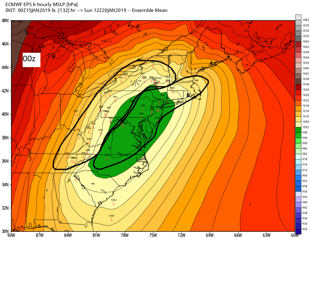
It seemed to catch onto a few systems first last year. Id love to see it if someone has images to post. Hree is the EPS. 00z vs 12z

_________________
"In weather and in life, there's no winning and losing; there's only winning and learning."
WINTER 2012/2013 TOTALS 43.65"WINTER 2017/2018 TOTALS 62.85" WINTER 2022/2023 TOTALS 4.9"
WINTER 2013/2014 TOTALS 64.85"WINTER 2018/2019 TOTALS 14.25" WINTER 2023/2024 TOTALS 13.1"
WINTER 2014/2015 TOTALS 71.20"WINTER 2019/2020 TOTALS 6.35"
WINTER 2015/2016 TOTALS 35.00"WINTER 2020/2021 TOTALS 37.75"
WINTER 2016/2017 TOTALS 42.25"WINTER 2021/2022 TOTALS 31.65"

sroc4- Admin

- Posts : 8354
Reputation : 302
Join date : 2013-01-07
Location : Wading River, LI
 Re: JANUARY 19TH-20TH STORM THREAT
HERE IS THE SEPARATION WE ARE TALKING ABOUT A FEW MORE LIKE THIS AND BOOM WE GO!!
EPS showing the separation - we may have something working here now peeps - look at the blue blobs in mid section pull apart - From Allen Weather pro met
.gif.473495fedc56f94faf94efab41194856.gif)
EPS showing the separation - we may have something working here now peeps - look at the blue blobs in mid section pull apart - From Allen Weather pro met
.gif.473495fedc56f94faf94efab41194856.gif)
_________________
Mugs
AKA:King: Snow Weenie
Self Proclaimed
WINTER 2014-15 : 55.12" +.02 for 6 coatings (avg. 35")
WINTER 2015-16 Total - 29.8" (Avg 35")
WINTER 2016-17 : 39.5" so far

amugs- Advanced Forecaster - Mod

- Posts : 15095
Reputation : 213
Join date : 2013-01-07
Age : 54
Location : Hillsdale,NJ
 Re: JANUARY 19TH-20TH STORM THREAT
Nice, Scott!!
rb924119- Meteorologist

- Posts : 6928
Reputation : 194
Join date : 2013-02-06
Age : 32
Location : Greentown, Pa
 Re: JANUARY 19TH-20TH STORM THREAT
I hope so my fingers are crossed I just want a freaking blizzard lolamugs wrote:HERE IS THE SEPARATION WE ARE TALKING ABOUT A FEW MORE LIKE THIS AND BOOM WE GO!!
EPS showing the separation - we may have something working here now peeps - look at the blue blobs in mid section pull apart - From Allen Weather pro met
frank 638- Senior Enthusiast

- Posts : 2843
Reputation : 37
Join date : 2016-01-01
Age : 40
Location : bronx ny
 Re: JANUARY 19TH-20TH STORM THREAT
Some other takeaways -amugs wrote:HERE IS THE SEPARATION WE ARE TALKING ABOUT A FEW MORE LIKE THIS AND BOOM WE GO!!
EPS showing the separation - we may have something working here now peeps - look at the blue blobs in mid section pull apart - From Allen Weather pro met
1. N EPO Stronger, sharper domain region
2. Heights/flow dampened on EC
3. A pseudo NAO press up in Greenland, that press the whole field down as well and acts as a pendulum to the 50/50 region
_________________
Mugs
AKA:King: Snow Weenie
Self Proclaimed
WINTER 2014-15 : 55.12" +.02 for 6 coatings (avg. 35")
WINTER 2015-16 Total - 29.8" (Avg 35")
WINTER 2016-17 : 39.5" so far

amugs- Advanced Forecaster - Mod

- Posts : 15095
Reputation : 213
Join date : 2013-01-07
Age : 54
Location : Hillsdale,NJ
 Re: JANUARY 19TH-20TH STORM THREAT
https://www.facebook.com/groups/304744922905296/permalink/2083483801698057/ deep thunder
Carvin- Posts : 44
Reputation : 2
Join date : 2019-01-09
 Re: JANUARY 19TH-20TH STORM THREAT
Map of DT - deep thunder - thanks Carvin


_________________
Mugs
AKA:King: Snow Weenie
Self Proclaimed
WINTER 2014-15 : 55.12" +.02 for 6 coatings (avg. 35")
WINTER 2015-16 Total - 29.8" (Avg 35")
WINTER 2016-17 : 39.5" so far

amugs- Advanced Forecaster - Mod

- Posts : 15095
Reputation : 213
Join date : 2013-01-07
Age : 54
Location : Hillsdale,NJ
 Re: JANUARY 19TH-20TH STORM THREAT
Carvin wrote:https://www.facebook.com/groups/304744922905296/permalink/2083483801698057/ deep thunder
Perfect! Thank you.
_________________
"In weather and in life, there's no winning and losing; there's only winning and learning."
WINTER 2012/2013 TOTALS 43.65"WINTER 2017/2018 TOTALS 62.85" WINTER 2022/2023 TOTALS 4.9"
WINTER 2013/2014 TOTALS 64.85"WINTER 2018/2019 TOTALS 14.25" WINTER 2023/2024 TOTALS 13.1"
WINTER 2014/2015 TOTALS 71.20"WINTER 2019/2020 TOTALS 6.35"
WINTER 2015/2016 TOTALS 35.00"WINTER 2020/2021 TOTALS 37.75"
WINTER 2016/2017 TOTALS 42.25"WINTER 2021/2022 TOTALS 31.65"

sroc4- Admin

- Posts : 8354
Reputation : 302
Join date : 2013-01-07
Location : Wading River, LI
 Re: JANUARY 19TH-20TH STORM THREAT
Great analysis guys. I'm hoping subtle changes aloft continue and are reflected in upcoming runs. I'm still looking at a good thump on the front end but I want more, lol. We need this 75-100 miles south and everybody will be happy.

hyde345- Pro Enthusiast

- Posts : 1082
Reputation : 48
Join date : 2013-01-08
Location : Hyde Park, NY
 Re: JANUARY 19TH-20TH STORM THREAT
It looks like National Weather Service is going with the colder and snowier forecast for the weekend discussion not out yet but point-and-click forecast are very snowy or icy

algae888- Advanced Forecaster

- Posts : 5311
Reputation : 46
Join date : 2013-02-05
Age : 62
Location : mt. vernon, new york
 Re: JANUARY 19TH-20TH STORM THREAT
I have a strong feeling that the cad is going to be under modeled and get stronger as we get closer to this event obviously a flip two other than snow for the coastal areas is definitely a concern but we should get a good front end thump for most areas

algae888- Advanced Forecaster

- Posts : 5311
Reputation : 46
Join date : 2013-02-05
Age : 62
Location : mt. vernon, new york
 Re: JANUARY 19TH-20TH STORM THREAT

_________________
"In weather and in life, there's no winning and losing; there's only winning and learning."
WINTER 2012/2013 TOTALS 43.65"WINTER 2017/2018 TOTALS 62.85" WINTER 2022/2023 TOTALS 4.9"
WINTER 2013/2014 TOTALS 64.85"WINTER 2018/2019 TOTALS 14.25" WINTER 2023/2024 TOTALS 13.1"
WINTER 2014/2015 TOTALS 71.20"WINTER 2019/2020 TOTALS 6.35"
WINTER 2015/2016 TOTALS 35.00"WINTER 2020/2021 TOTALS 37.75"
WINTER 2016/2017 TOTALS 42.25"WINTER 2021/2022 TOTALS 31.65"

sroc4- Admin

- Posts : 8354
Reputation : 302
Join date : 2013-01-07
Location : Wading River, LI
 Re: JANUARY 19TH-20TH STORM THREAT
algae888 wrote:I have a strong feeling that the cad is going to be under modeled and get stronger as we get closer to this event obviously a flip two other than snow for the coastal areas is definitely a concern but we should get a good front end thump for most areas
I believe the south and east trend continue and we will start seeing at the surface on model runs to come.

skinsfan1177- Senior Enthusiast

- Posts : 4485
Reputation : 35
Join date : 2013-01-07
Age : 46
Location : Point Pleasant Boro
 Re: JANUARY 19TH-20TH STORM THREAT
We’re going snow 2-4” for all then to rain on the coast mix north and all snow way north Sunday am then back to heavy snow nw to se Sunday afternoon evening. 6-18” SE TO NW. I’ve seen this game before.
Guest- Guest
 Re: JANUARY 19TH-20TH STORM THREAT
18z GFS more of the same. Amped and too far north and west.

hyde345- Pro Enthusiast

- Posts : 1082
Reputation : 48
Join date : 2013-01-08
Location : Hyde Park, NY
 Re: JANUARY 19TH-20TH STORM THREAT
I'm just go sit back and see what happens. I'm not adding weather to my stress bucket its just not worth it. I am hoping for the best and just reading what you guys are saying and try make my own opinions but I won't say them cuz I honestly will prolly sound dumb. On that note keep us up to date fruquently if possible. So far I feel mixed which way it might go.

jmanley32- Senior Enthusiast

- Posts : 20535
Reputation : 108
Join date : 2013-12-12
Age : 43
Location : Yonkers, NY
 Re: JANUARY 19TH-20TH STORM THREAT
jmanley32 wrote:I'm just go sit back and see what happens. I'm not adding weather to my stress bucket its just not worth it. I am hoping for the best and just reading what you guys are saying and try make my own opinions but I won't say them cuz I honestly will prolly sound dumb. On that note keep us up to date fruquently if possible. So far I feel mixed which way it might go.
Please share!! That’s what this forum is for! Judgement-free zone........but we’re better than Planet Fitness
rb924119- Meteorologist

- Posts : 6928
Reputation : 194
Join date : 2013-02-06
Age : 32
Location : Greentown, Pa
 Re: JANUARY 19TH-20TH STORM THREAT
rb924119 wrote:jmanley32 wrote:I'm just go sit back and see what happens. I'm not adding weather to my stress bucket its just not worth it. I am hoping for the best and just reading what you guys are saying and try make my own opinions but I won't say them cuz I honestly will prolly sound dumb. On that note keep us up to date fruquently if possible. So far I feel mixed which way it might go.
Please share!! That’s what this forum is for! Judgement-free zone........but we’re better than Planet Fitness
Do we have a Lunk alarm like planet fitness

skinsfan1177- Senior Enthusiast

- Posts : 4485
Reputation : 35
Join date : 2013-01-07
Age : 46
Location : Point Pleasant Boro
 Re: JANUARY 19TH-20TH STORM THREAT
rb924119 wrote:jmanley32 wrote:I'm just go sit back and see what happens. I'm not adding weather to my stress bucket its just not worth it. I am hoping for the best and just reading what you guys are saying and try make my own opinions but I won't say them cuz I honestly will prolly sound dumb. On that note keep us up to date fruquently if possible. So far I feel mixed which way it might go.
Please share!! That’s what this forum is for! Judgement-free zone........but we’re better than Planet Fitness
rb..just watched bernie rayno..do you have time to look at it and give your opinion? I am usually a half glass full kinda gal..but not feeling good about any of this...

weatherwatchermom- Senior Enthusiast

- Posts : 3793
Reputation : 78
Join date : 2014-11-25
Location : Hazlet Township, NJ
 Re: JANUARY 19TH-20TH STORM THREAT
i still think when all is said and done nyc/5 boros and l.i were gonna get hit big time weekend or 1/23
mwilli5783- Posts : 146
Reputation : 9
Join date : 2013-01-23
Age : 69
Location : hempstead n.y
 Re: JANUARY 19TH-20TH STORM THREAT
I hope this thing slides at least a little southeast. I'm starting to feel guilty about my excitement.
Guest- Guest
 Re: JANUARY 19TH-20TH STORM THREAT
LOL don't we are all greedy snow moungrals, "gimmi it its mine!!" LOL, I do however hope it can somehow clobber everyone.TheAresian wrote:I hope this thing slides at least a little southeast. I'm starting to feel guilty about my excitement.

jmanley32- Senior Enthusiast

- Posts : 20535
Reputation : 108
Join date : 2013-12-12
Age : 43
Location : Yonkers, NY
Page 1 of 21 • 1, 2, 3 ... 11 ... 21 
Page 1 of 21
Permissions in this forum:
You cannot reply to topics in this forum|
|
|

 Home
Home