JANUARY 19TH-20TH STORM THREAT
+44
gigs68
ndionyssiou
docstox12
Taffy
HectorO
SENJsnowman
jake732
SoulSingMG
Smitty623
GreyBeard
jimv45
mmanisca
DAYBLAZER
emokid51783
Irish
Grselig
lglickman1
oldtimer
Dunnzoo
Radz
CPcantmeasuresnow
Joe Snow
Frank_Wx
Sanchize06
dkodgis
Vinnydula
snowlover 12345
Scullybutcher
nutleyblizzard
billg315
aiannone
heehaw453
mwilli5783
weatherwatchermom
jmanley32
skinsfan1177
algae888
hyde345
Carvin
frank 638
rb924119
bobjohnsonforthehall
amugs
sroc4
48 posters
Page 15 of 21
Page 15 of 21 •  1 ... 9 ... 14, 15, 16 ... 21
 Re: JANUARY 19TH-20TH STORM THREAT
rb924119 wrote:Biggest red flag to me, and people can make fun of me all they want, but seeing how far south and COLD the SREFs are at this range (when they are normally the most amplified ensemble) is a tremendous signal that further corrections south on other guidance (most notably the EURO, GFS, and GEM suites) are more likely than not in future runs.
rb here is uptons disco. they are not using gfs and are siding with colder solutions.
"arctic high pressure will be located across southeast Canada and
ridge down into New England on Saturday. At the same time, a
southern stream shortwave spawns low pressure across the southeast.
The southern stream is progged to remain progressive and positively
tilted with little phasing from the polar jet to the north. It
appears that the influence of the northern stream will not come into
play until the southern stream wave is near the east coast. This has
led to a consensus of a colder solution and a track of the low
further south and east than the previous forecast package. Dprog/dt
on the recent deterministic runs shows this general trend well
except the GFS/GEFS which appear to be an outlier solution and
remain much warmer than the rest of the guidance. The main energy
with the southern stream wave will be coming onshore today. There is
also sensitivity as noted above with the how much the polar jet
interacts and phases with the southern stream, so changes in track
forecast are still possible in subsequent forecast packages."
algae888- Advanced Forecaster

- Posts : 5311
Join date : 2013-02-05
 Re: JANUARY 19TH-20TH STORM THREAT
National weather service has issued winter storm watch for North and west of the city and east of the city hopefully today we will have a better idea of what's going on.i hope we all get a decent amount of snow not ice or sleet
frank 638- Senior Enthusiast

- Posts : 2824
Join date : 2016-01-01
 Re: JANUARY 19TH-20TH STORM THREAT
docstox12 wrote:NWS this morning has me in the LHV at 5 to 9 for the event with sleet and FR on Sunday.Hope rb's SREF analysis pans out and this shifts S and E .
Trust the process
rb924119- Meteorologist

- Posts : 6889
Reputation : 194
Join date : 2013-02-06
Age : 32
Location : Greentown, Pa
 Re: JANUARY 19TH-20TH STORM THREAT
Thanks, Al. Yeah, even the overnight EPS is colder and snowier than the Op Euro, and actually is in the UKMET/SREF camp.
rb924119- Meteorologist

- Posts : 6889
Reputation : 194
Join date : 2013-02-06
Age : 32
Location : Greentown, Pa
 Re: JANUARY 19TH-20TH STORM THREAT
Winter storm watces are up for North West of the city and east of the city I wonder why they don't of the city in a watch yet
frank 638- Senior Enthusiast

- Posts : 2824
Reputation : 37
Join date : 2016-01-01
Age : 40
Location : bronx ny
 Re: JANUARY 19TH-20TH STORM THREAT
frank 638 wrote:Winter storm watces are up for North West of the city and east of the city I wonder why they don't of the city in a watch yet
Too much uncertainty. I’m shocked they’re putting advisories out anywhere at this point. Still do much time. This is when crap usually goes wrong for everybody, to be honest. They get everybody hyped up and it either misses completely or turns out to be a dud lol this is bad mojo and I don’t like it ahaha
rb924119- Meteorologist

- Posts : 6889
Reputation : 194
Join date : 2013-02-06
Age : 32
Location : Greentown, Pa

jmanley32- Senior Enthusiast

- Posts : 20513
Reputation : 108
Join date : 2013-12-12
Age : 42
Location : Yonkers, NY
 Re: JANUARY 19TH-20TH STORM THREAT
Wsw 3 days ahead of time we didn't even get a wwa for tonight yet lol they must really be worried about this storm. Imo its the ice potential cuz usually snow watches are about 36 hrs out not 72 or more.

jmanley32- Senior Enthusiast

- Posts : 20513
Reputation : 108
Join date : 2013-12-12
Age : 42
Location : Yonkers, NY
 Re: JANUARY 19TH-20TH STORM THREAT
This is going to be a lot of fun watching the little jogs this models will pick up on the next few days!The area is so close to a major snowstorm!

docstox12- Wx Statistician Guru

- Posts : 8502
Reputation : 222
Join date : 2013-01-07
Age : 73
Location : Monroe NY
 Re: JANUARY 19TH-20TH STORM THREAT
So Red Sox Suck getting a Godzilla and NYC a slip fest. Hopefully we can tick South and get into the goods. Not happy
Guest- Guest
 Re: JANUARY 19TH-20TH STORM THREAT
I hear ya especially since beabtown us prolly go see closer to a roudzilla. I just wanna see snow and syo I think this does go in our favor last minute but the waiting is what's so hard.syosnow94 wrote:So Red Sox Suck getting a Godzilla and NYC a slip fest. Hopefully we can tick South and get into the goods. Not happy

jmanley32- Senior Enthusiast

- Posts : 20513
Reputation : 108
Join date : 2013-12-12
Age : 42
Location : Yonkers, NY
 Re: JANUARY 19TH-20TH STORM THREAT
6z Nam is way south and much colder. Low exits the Delaware coast.

nutleyblizzard- Senior Enthusiast

- Posts : 1952
Reputation : 41
Join date : 2014-01-30
Age : 58
Location : Nutley, new jersey
 Re: JANUARY 19TH-20TH STORM THREAT
Interesting the NAM doesn’t go over to rain for much of Central and North NJ; but only snow the first few hours then it is a long duration of freezing rain, sleet, mix before ending Sunday afternoon.

billg315- Advanced Forecaster - Mod

- Posts : 4462
Reputation : 185
Join date : 2015-01-24
Age : 50
Location : Flemington, NJ
 Re: JANUARY 19TH-20TH STORM THREAT
What are the implications of a low popping off coast like Srefs and other models show

skinsfan1177- Senior Enthusiast

- Posts : 4485
Reputation : 35
Join date : 2013-01-07
Age : 46
Location : Point Pleasant Boro
 Re: JANUARY 19TH-20TH STORM THREAT
Is this similar to the bomb cyclone from last Jan? Remember the liw then?

dkodgis- Senior Enthusiast

- Posts : 2496
Reputation : 98
Join date : 2013-12-29
 Re: JANUARY 19TH-20TH STORM THREAT
Brining back this map here from Tuesday:
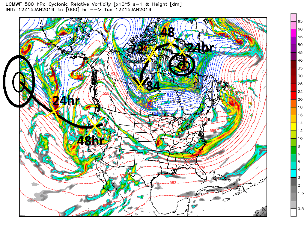
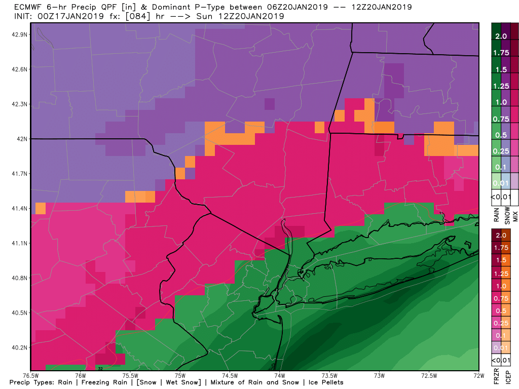
You can see that our main S energy will be coming onshore today. Our S energy and N energy is approx where the 48hr yellow X is. Therefore the final push to track consensus should occur with 12z and 00z today and tonight. But notice our N energy is still way N of good sampling. Already we are looking at a track that appears to take the surface low off the S jersey to Delmarva region and track it south of NYC and LI. GFS is the N&W outlier but even there both 00z and 6z track the surface low right over NYC. In reality the track between the euro and GFS MSLP are not that far apart; however their R/S line appears to be.
Next up is the 850mb level. There is a closed 850mb level low that seems to track right over NYC on the euro whereas the GFS takes its center N&W. Below are the 850mb maps from last nights euro. I have outlined the center of the closed 850mb low. You can see the dividing line of above and below freezing temps pretty clearly
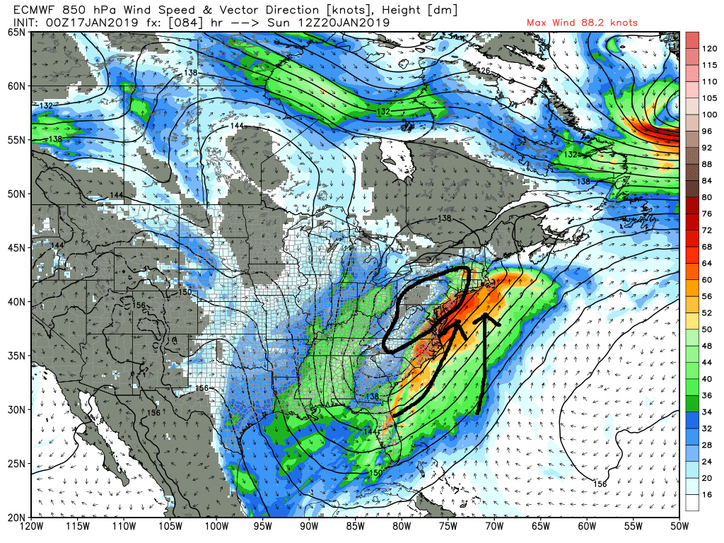
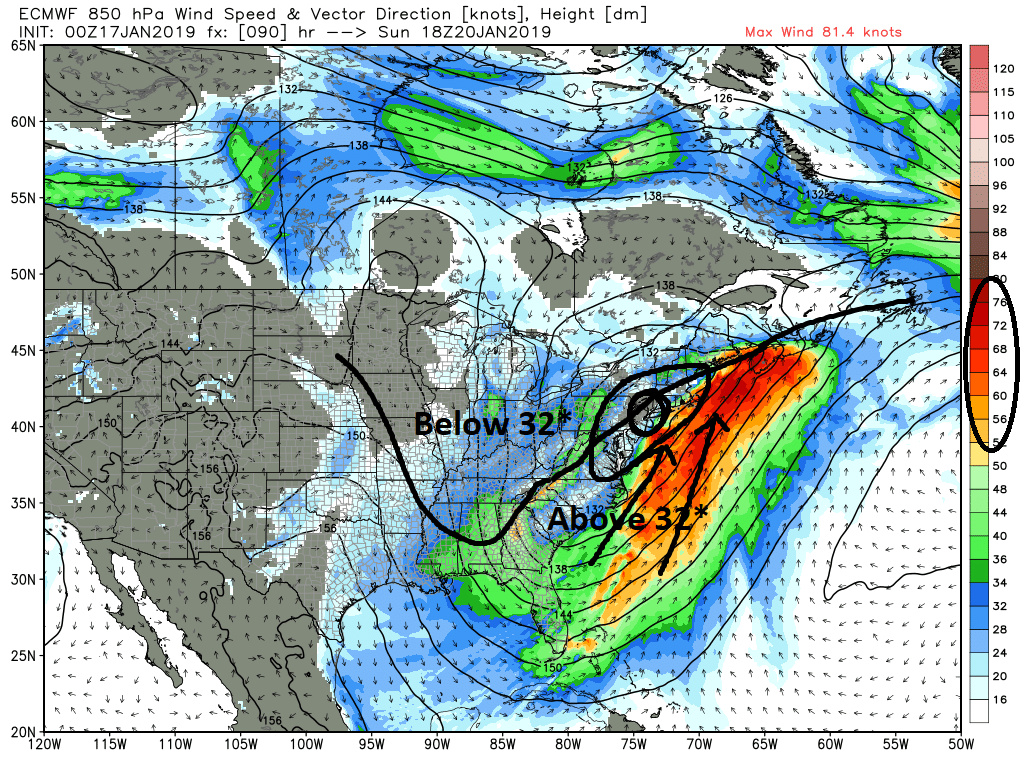
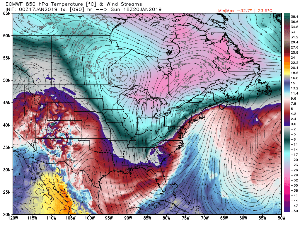
As you can see highlighted by the black arrows on the SE side of the low there is an intense 850mb jet streak brining in the dreaded "warm nose". You can also see by the 700mb relative humidity map below the moisture feed and source region out ahead of the storm originates from deep within the subtropics and tropics and SE Atlantic.
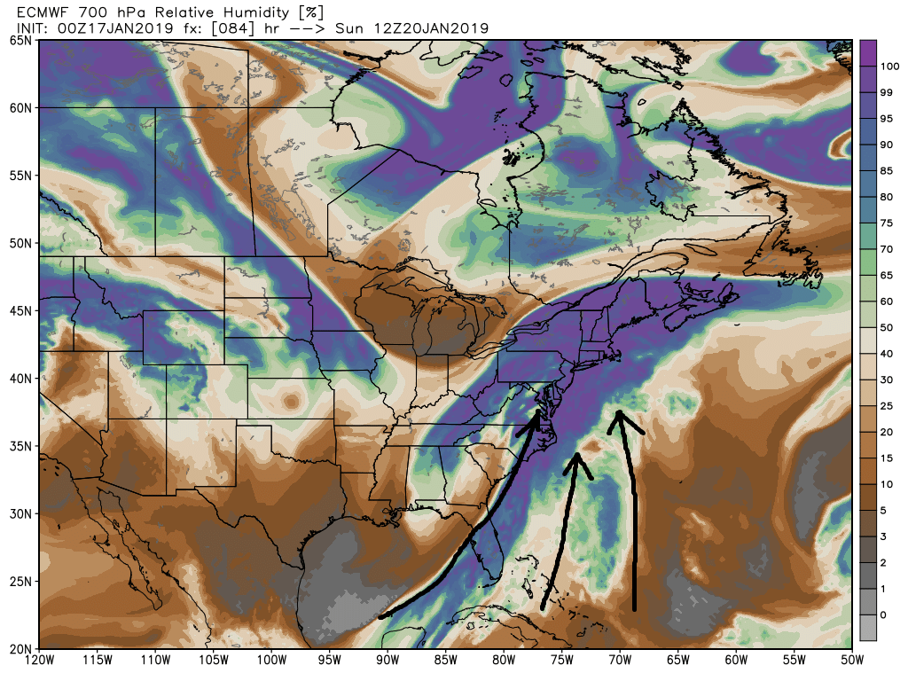
So whats my point? Well with the surface low beginning to come into focus, although there is still changes possible as our energy is only today beginning better sampling, the 850mb low if it is closed as it approaches will dictate just how far N&W the warm nose can push. While the surface low has trended S&E over the last 2 days so has the 850mb low as well. See below
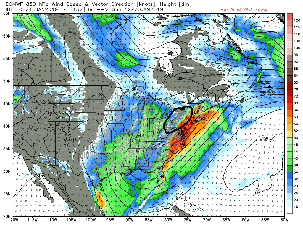
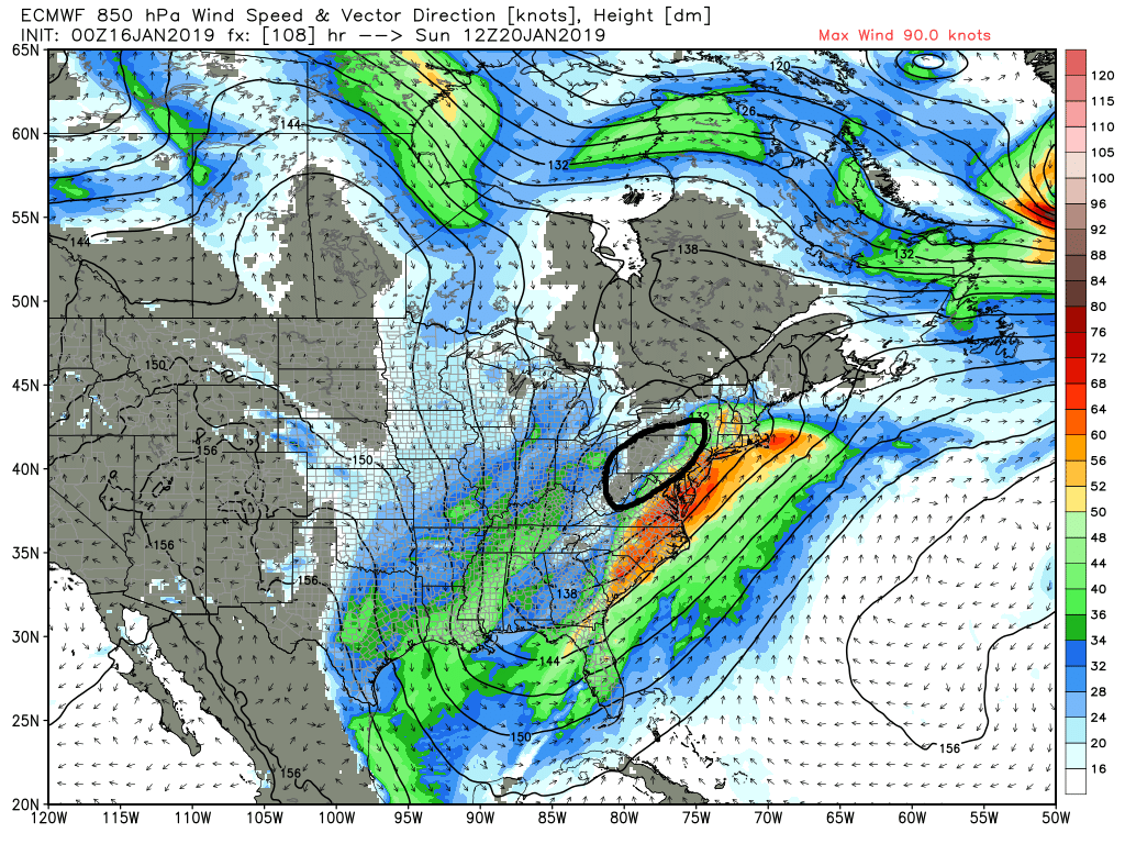
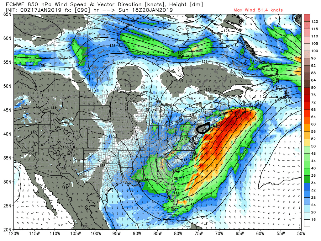
Again the next 24hrs will be telling in my opinion. I would really like to see that850mb low also trend further S&E. IF we see that 850mb low slide south of LI as well even the coast will see surpises. And I cant believe im going to reference Steve D here but I agree with his statement Alex posted overnight. That is to never underestimate the power of an arctic high, which is exactly what we have in place to the N as the system approaches. I said it yesterday we will likely see last minute surprises right down to the wire...aka nowcasting will be important.

You can see that our main S energy will be coming onshore today. Our S energy and N energy is approx where the 48hr yellow X is. Therefore the final push to track consensus should occur with 12z and 00z today and tonight. But notice our N energy is still way N of good sampling. Already we are looking at a track that appears to take the surface low off the S jersey to Delmarva region and track it south of NYC and LI. GFS is the N&W outlier but even there both 00z and 6z track the surface low right over NYC. In reality the track between the euro and GFS MSLP are not that far apart; however their R/S line appears to be.
Next up is the 850mb level. There is a closed 850mb level low that seems to track right over NYC on the euro whereas the GFS takes its center N&W. Below are the 850mb maps from last nights euro. I have outlined the center of the closed 850mb low. You can see the dividing line of above and below freezing temps pretty clearly


As you can see highlighted by the black arrows on the SE side of the low there is an intense 850mb jet streak brining in the dreaded "warm nose". You can also see by the 700mb relative humidity map below the moisture feed and source region out ahead of the storm originates from deep within the subtropics and tropics and SE Atlantic.

So whats my point? Well with the surface low beginning to come into focus, although there is still changes possible as our energy is only today beginning better sampling, the 850mb low if it is closed as it approaches will dictate just how far N&W the warm nose can push. While the surface low has trended S&E over the last 2 days so has the 850mb low as well. See below


Again the next 24hrs will be telling in my opinion. I would really like to see that850mb low also trend further S&E. IF we see that 850mb low slide south of LI as well even the coast will see surpises. And I cant believe im going to reference Steve D here but I agree with his statement Alex posted overnight. That is to never underestimate the power of an arctic high, which is exactly what we have in place to the N as the system approaches. I said it yesterday we will likely see last minute surprises right down to the wire...aka nowcasting will be important.
_________________
"In weather and in life, there's no winning and losing; there's only winning and learning."
WINTER 2012/2013 TOTALS 43.65"WINTER 2017/2018 TOTALS 62.85" WINTER 2022/2023 TOTALS 4.9"
WINTER 2013/2014 TOTALS 64.85"WINTER 2018/2019 TOTALS 14.25" WINTER 2023/2024 TOTALS 13.1"
WINTER 2014/2015 TOTALS 71.20"WINTER 2019/2020 TOTALS 6.35"
WINTER 2015/2016 TOTALS 35.00"WINTER 2020/2021 TOTALS 37.75"
WINTER 2016/2017 TOTALS 42.25"WINTER 2021/2022 TOTALS 31.65"

sroc4- Admin

- Posts : 8331
Reputation : 301
Join date : 2013-01-07
Location : Wading River, LI
 Re: JANUARY 19TH-20TH STORM THREAT
On all news channels the temperature is showing lower numbers for sunday nyc
Carvin- Posts : 44
Reputation : 2
Join date : 2019-01-09
 Re: JANUARY 19TH-20TH STORM THREAT
The GFS/EURO OP models are fairly warm for the area.
The UKMET, SREFS, NAM and NAVGEM are very cold.
We do not have a solution but I'm beginning to get an idea in my head on who will see what.
The UKMET, SREFS, NAM and NAVGEM are very cold.
We do not have a solution but I'm beginning to get an idea in my head on who will see what.
_________________
_______________________________________________________________________________________________________
CLICK HERE to view NJ Strong Snowstorm Classifications
 Re: JANUARY 19TH-20TH STORM THREAT
Take into consideration that the GEFS and EPS are south and east of the GFS/EURO OPS. Last nights UKIE trended even more SE from the 12z run.Frank_Wx wrote:The GFS/EURO OP models are fairly warm for the area.
The UKMET, SREFS, NAM and NAVGEM are very cold.
We do not have a solution but I'm beginning to get an idea in my head on who will see what.

nutleyblizzard- Senior Enthusiast

- Posts : 1952
Reputation : 41
Join date : 2014-01-30
Age : 58
Location : Nutley, new jersey
 Re: JANUARY 19TH-20TH STORM THREAT
jmanley32 wrote:I hear ya especially since beabtown us prolly go see closer to a roudzilla. I just wanna see snow and syo I think this does go in our favor last minute but the waiting is what's so hard.syosnow94 wrote:So Red Sox Suck getting a Godzilla and NYC a slip fest. Hopefully we can tick South and get into the goods. Not happy
You guys are really B oston obsessed.
You do realize they have had 0.2 inches of snow so far this whole season, and during the November 15th storm they had all rain except the 0.2 inches of snow at the end when most in our area had 6-12 inches of snow.
Being east hurts them as much as it sometimes helps. The storm could go either way for them and has just as much a chance of being rain and slop there because of how far east they are as here. 30 miles N&W of NYC has a better chance to do well in this storm than Red Sox Suck IMO. WTS both sections may very well be screwed by Freezing rain.

CPcantmeasuresnow- Wx Statistician Guru

- Posts : 7274
Reputation : 230
Join date : 2013-01-07
Age : 103
Location : Eastern Orange County, NY
 Re: JANUARY 19TH-20TH STORM THREAT
Frank_Wx wrote:The GFS/EURO OP models are fairly warm for the area.
The UKMET, SREFS, NAM and NAVGEM are very cold.
We do not have a solution but I'm beginning to get an idea in my head on who will see what.
When Frank says this I’m pretty sure after all these years I know how he is leaning. Plus the Brutally cold high tonthe north WILL NOT allow the 850 LP to track too far north. Lets start following the short range high res models for thermal profiles
I predict he makes a map of a mithrazilla with mixing issues coast (6-12”) and a Godzilla from the Tappan Zee bridge northh. Just sayin.
Guest- Guest
 Re: JANUARY 19TH-20TH STORM THREAT
CPcantmeasuresnow wrote:jmanley32 wrote:I hear ya especially since beabtown us prolly go see closer to a roudzilla. I just wanna see snow and syo I think this does go in our favor last minute but the waiting is what's so hard.syosnow94 wrote:So Red Sox Suck getting a Godzilla and NYC a slip fest. Hopefully we can tick South and get into the goods. Not happy
You guys are really B oston obsessed.
You do realize they have had 0.2 inches of snow so far this whole season, and during the November 15th storm they had all rain except the 0.2 inches of snow at the end when most in our area had 6-12 inches of snow.
Being east hurts them as much as it sometimes helps. The storm could go either way for them and has just as much a chance of being rain and slop there because of how far east they are as here. 30 miles N&W of NYC has a better chance to do well in this storm than Red Sox Suck IMO. WTS both sections may very well be screwed by Freezing rain.
And it has become evident that you my good friend are a closeted Red Sox Suck Defender. Any time someone mentions Red Sox Suck you pop up within a second with a defense. It’s like someone’s picking on your mom ?
Guest- Guest
 Re: JANUARY 19TH-20TH STORM THREAT
Who’s going to be the first to take a crack at a map?
Scullybutcher- Pro Enthusiast

- Posts : 543
Reputation : 16
Join date : 2013-02-06
Location : North Smithtown, western Suffolk county, long island
 Re: JANUARY 19TH-20TH STORM THREAT
Scullybutcher wrote:Who’s going to be the first to take a crack at a map?
come on Syos...I love your maps!!!

weatherwatchermom- Senior Enthusiast

- Posts : 3735
Reputation : 77
Join date : 2014-11-25
Age : 60
Location : Hazlet Township, NJ
 Re: JANUARY 19TH-20TH STORM THREAT
Scullybutcher wrote:Who’s going to be the first to take a crack at a map?
I’m your huckleberry Skully

YELLOW. 1-2” snow then rain
GREEN 2-5” snow then mix then rain then backend 1-2” snow
BLUE 5-10” snow then mix then backend 2-3” snow
RED all snow all the time 12-20” highest north
BLACK. All rain all the time. Ha
Last edited by syosnow94 on Thu Jan 17, 2019 8:54 am; edited 2 times in total
Guest- Guest
 Re: JANUARY 19TH-20TH STORM THREAT
The watch issued for the western front is calling for 12-20". I know I'm being greedy at this point, but if this storm isn't bigger than November's then I am going to be seriously disappointed.
Guest- Guest

weatherwatchermom- Senior Enthusiast

- Posts : 3735
Reputation : 77
Join date : 2014-11-25
Age : 60
Location : Hazlet Township, NJ
Page 15 of 21 •  1 ... 9 ... 14, 15, 16 ... 21
Page 15 of 21
Permissions in this forum:
You cannot reply to topics in this forum|
|
|

 Home
Home