JANUARY 19TH-20TH STORM THREAT
+44
gigs68
ndionyssiou
docstox12
Taffy
HectorO
SENJsnowman
jake732
SoulSingMG
Smitty623
GreyBeard
jimv45
mmanisca
DAYBLAZER
emokid51783
Irish
Grselig
lglickman1
oldtimer
Dunnzoo
Radz
CPcantmeasuresnow
Joe Snow
Frank_Wx
Sanchize06
dkodgis
Vinnydula
snowlover 12345
Scullybutcher
nutleyblizzard
billg315
aiannone
heehaw453
mwilli5783
weatherwatchermom
jmanley32
skinsfan1177
algae888
hyde345
Carvin
frank 638
rb924119
bobjohnsonforthehall
amugs
sroc4
48 posters
Page 3 of 21
Page 3 of 21 •  1, 2, 3, 4 ... 12 ... 21
 Re: JANUARY 19TH-20TH STORM THREAT
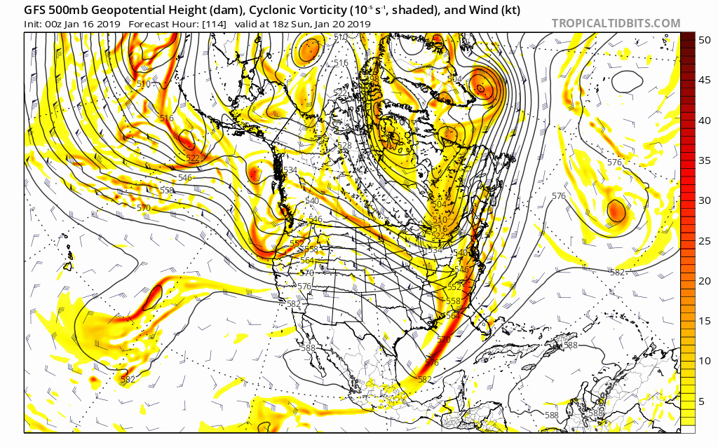
PNA ridge breaks down, High further south and boom that is why we see this way south jog on the 0z GFS
aiannone- Senior Enthusiast - Mod

- Posts : 4815
Join date : 2013-01-07
 Re: JANUARY 19TH-20TH STORM THREAT
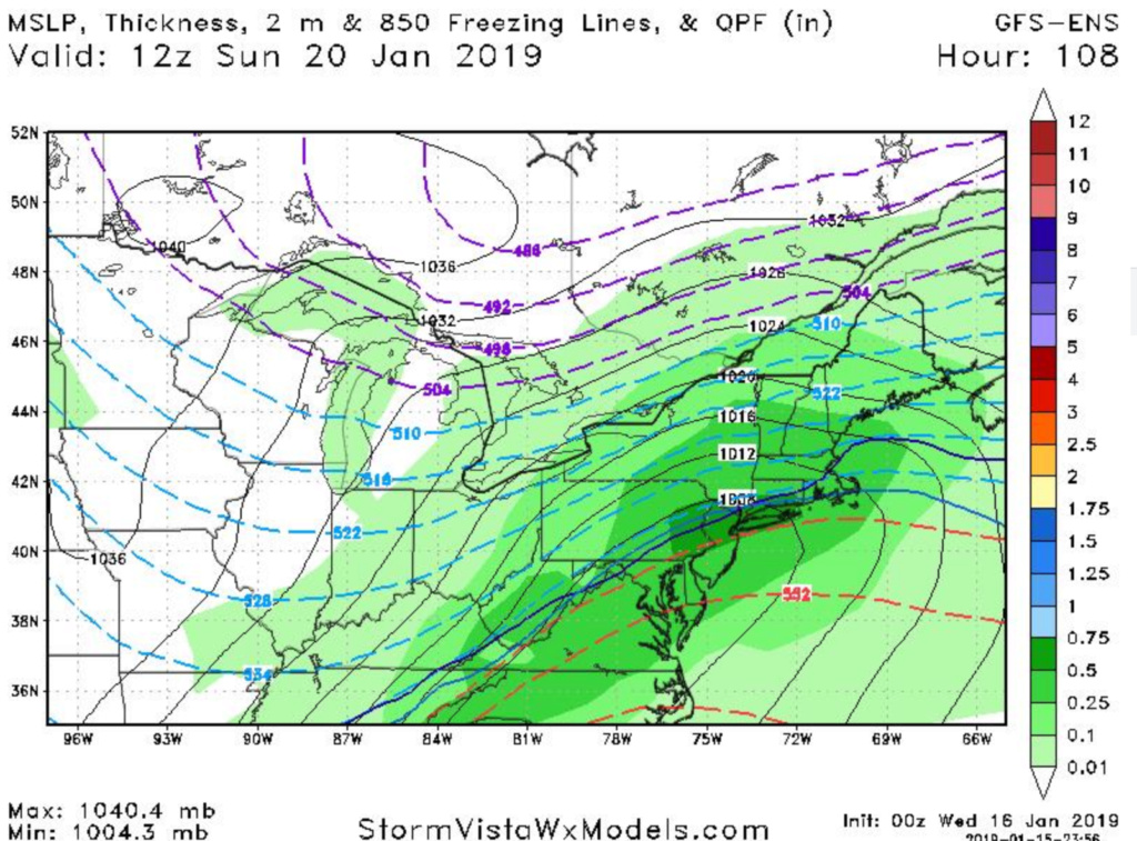
Huge shift south on 00z GFS surface map!!
jmanley32- Senior Enthusiast

- Posts : 20535
Join date : 2013-12-12
 Re: JANUARY 19TH-20TH STORM THREAT
Definitely a nice improvement. If we can keep trending in that direction, we'll be in good shape
Sanchize06- Senior Enthusiast

- Posts : 1041
Reputation : 21
Join date : 2013-02-05
Location : Union Beach, NJ
 Re: JANUARY 19TH-20TH STORM THREAT
Sets up for another ice storm senarion for coast, but one more push south and we are all golden white.

jmanley32- Senior Enthusiast

- Posts : 20535
Reputation : 108
Join date : 2013-12-12
Age : 43
Location : Yonkers, NY
 Re: JANUARY 19TH-20TH STORM THREAT
_________________
Mugs
AKA:King: Snow Weenie
Self Proclaimed
WINTER 2014-15 : 55.12" +.02 for 6 coatings (avg. 35")
WINTER 2015-16 Total - 29.8" (Avg 35")
WINTER 2016-17 : 39.5" so far

amugs- Advanced Forecaster - Mod

- Posts : 15095
Reputation : 213
Join date : 2013-01-07
Age : 54
Location : Hillsdale,NJ
 Re: JANUARY 19TH-20TH STORM THREAT
aiannone wrote:PNA ridge breaks down, High further south and boom that is why we see this way south jog on the 0z GFS
I just posted this is what we need
Guest- Guest

jmanley32- Senior Enthusiast

- Posts : 20535
Reputation : 108
Join date : 2013-12-12
Age : 43
Location : Yonkers, NY
 Re: JANUARY 19TH-20TH STORM THREAT
0z CMC still mostly rain. Low rides over DC moves NE and then exits of the NJ coast south of LI. Brief changeover at the end. But also a jog south and east
_________________
-Alex Iannone-

aiannone- Senior Enthusiast - Mod

- Posts : 4815
Reputation : 92
Join date : 2013-01-07
Location : Saint James, LI (Northwest Suffolk Co.)

hyde345- Pro Enthusiast

- Posts : 1082
Reputation : 48
Join date : 2013-01-08
Location : Hyde Park, NY
 Re: JANUARY 19TH-20TH STORM THREAT
UKIE holds and serve .....GN peeos. Very positive trends so far. Let's see what that PITA DR. No has to say come morning.
_________________
Mugs
AKA:King: Snow Weenie
Self Proclaimed
WINTER 2014-15 : 55.12" +.02 for 6 coatings (avg. 35")
WINTER 2015-16 Total - 29.8" (Avg 35")
WINTER 2016-17 : 39.5" so far

amugs- Advanced Forecaster - Mod

- Posts : 15095
Reputation : 213
Join date : 2013-01-07
Age : 54
Location : Hillsdale,NJ
 Re: JANUARY 19TH-20TH STORM THREAT
The shift at 500mb on the 00z GFS could be the saving grace we needed in this dreadful winter. The GFS just trended to the UKIE, and the 00z UKIE run tonight STILL shows a major snowstorm for our area.
The PNA ridge broke down, the southern stream energy was more fierce, and the northern stream energy outpaced it. There was hardly any phasing. Exactly what we needed.
One more positive step with models tomorrow and it could be game on. Or, a step backwards means this will turn out to be a snow to rain event. Although I remain in favor of that scenario, I am absolutely loving the GFS and UKIE runs tonight.
Madonne!
_________________
_______________________________________________________________________________________________________
CLICK HERE to view NJ Strong Snowstorm Classifications
 Re: JANUARY 19TH-20TH STORM THREAT
jmanley32 wrote:For one run, it still has me on edge as this is 4 to 5 days out and plenty can shift back the other way, I really hope this trending continues just a bit further south to get us all in and then it stays there. I am staying very cautious, with hope in my heart.
It will waffle back and forth till she settles in, I am still thinking we cash in on the White Gold on Sunday. The trend is your friend.

Joe Snow- Pro Enthusiast

- Posts : 924
Reputation : 7
Join date : 2014-02-12
Age : 62
Location : Sanford Florida, Fmrly Kings Park, NY
 Re: JANUARY 19TH-20TH STORM THREAT
Weather repeats folks. The pna ridge broke down last week and is looking like it may again. Usually this is bad for us but this winter is so effed up thatvwhats usually bad may be good!
Guest- Guest
 Re: JANUARY 19TH-20TH STORM THREAT
Frank_Wx wrote:The shift at 500mb on the 00z GFS could be the saving grace we needed in this dreadful winter. The GFS just trended to the UKIE, and the 00z UKIE run tonight STILL shows a major snowstorm for our area.
The PNA ridge broke down, the southern stream energy was more fierce, and the northern stream energy outpaced it. There was hardly any phasing. Exactly what we needed.
One more positive step with models tomorrow and it could be game on. Or, a step backwards means this will turn out to be a snow to rain event. Although I remain in favor of that scenario, I am absolutely loving the GFS and UKIE runs tonight.
Madonne!


CPcantmeasuresnow- Wx Statistician Guru

- Posts : 7274
Reputation : 230
Join date : 2013-01-07
Age : 103
Location : Eastern Orange County, NY

aiannone- Senior Enthusiast - Mod

- Posts : 4815
Reputation : 92
Join date : 2013-01-07
Location : Saint James, LI (Northwest Suffolk Co.)

CPcantmeasuresnow- Wx Statistician Guru

- Posts : 7274
Reputation : 230
Join date : 2013-01-07
Age : 103
Location : Eastern Orange County, NY
 Re: JANUARY 19TH-20TH STORM THREAT
Well you can add the Euro to the list of great model trends for tonight 6 to 12 in of snow for the area followed by sleet freezing rain and plain rain along the coast then back to snow before it ends great Trends tonight

algae888- Advanced Forecaster

- Posts : 5311
Reputation : 46
Join date : 2013-02-05
Age : 62
Location : mt. vernon, new york
 Re: JANUARY 19TH-20TH STORM THREAT
One thing that I need to ask the more knowledgable in here is is see all positive signs in model runs last night the things we need for snowier solutions but it seems not to reflect the surface in my area. Will the maps eventually show snowier solutions here on CNJ coast?

skinsfan1177- Senior Enthusiast

- Posts : 4485
Reputation : 35
Join date : 2013-01-07
Age : 46
Location : Point Pleasant Boro
 Re: JANUARY 19TH-20TH STORM THREAT
Love what I see this am euro followed and now all models have pushed south
Check out deep thunder lol 43 inches bullseye for beabtown and Easter ma lol. 17 for NYC. Font care doubt that's true but I'd take 17 in a heartbeat! Even 6 to 12 sounds awesome but come on guys lets get the beast hoisted in a few days! Frank said the M word!
Check out deep thunder lol 43 inches bullseye for beabtown and Easter ma lol. 17 for NYC. Font care doubt that's true but I'd take 17 in a heartbeat! Even 6 to 12 sounds awesome but come on guys lets get the beast hoisted in a few days! Frank said the M word!

jmanley32- Senior Enthusiast

- Posts : 20535
Reputation : 108
Join date : 2013-12-12
Age : 43
Location : Yonkers, NY
 Re: JANUARY 19TH-20TH STORM THREAT
I know I hate off-hour runs, ESPECIALLY the FV3 (which has been horrible), but positive changes so far on 06z run are phenomenal  good night all lol
rb924119- Meteorologist

- Posts : 6928
Reputation : 194
Join date : 2013-02-06
Age : 32
Location : Greentown, Pa
 Re: JANUARY 19TH-20TH STORM THREAT
ALL IM GONNA SAY IS HOLY 06Z GEFS
rb924119- Meteorologist

- Posts : 6928
Reputation : 194
Join date : 2013-02-06
Age : 32
Location : Greentown, Pa
 Re: JANUARY 19TH-20TH STORM THREAT
rb924119 wrote:ALL IM GONNA SAY IS HOLY 06Z GEFS
Very nice!
heehaw453- Advanced Forecaster

- Posts : 3906
Reputation : 86
Join date : 2014-01-20
Location : Bedminster Township, PA Elevation 600' ASL
 Re: JANUARY 19TH-20TH STORM THREAT
skinsfan1177 wrote:One thing that I need to ask the more knowledgable in here is is see all positive signs in model runs last night the things we need for snowier solutions but it seems not to reflect the surface in my area. Will the maps eventually show snowier solutions here on CNJ coast?
With less phasing you don't get the arctic air in as quick. That would be my guess.
_________________
"In weather and in life, there's no winning and losing; there's only winning and learning."
WINTER 2012/2013 TOTALS 43.65"WINTER 2017/2018 TOTALS 62.85" WINTER 2022/2023 TOTALS 4.9"
WINTER 2013/2014 TOTALS 64.85"WINTER 2018/2019 TOTALS 14.25" WINTER 2023/2024 TOTALS 13.1"
WINTER 2014/2015 TOTALS 71.20"WINTER 2019/2020 TOTALS 6.35"
WINTER 2015/2016 TOTALS 35.00"WINTER 2020/2021 TOTALS 37.75"
WINTER 2016/2017 TOTALS 42.25"WINTER 2021/2022 TOTALS 31.65"

sroc4- Admin

- Posts : 8354
Reputation : 302
Join date : 2013-01-07
Location : Wading River, LI
 Re: JANUARY 19TH-20TH STORM THREAT
WOW. NWS going all ALL RAIN except for far nw areas where there could be a mix and then brutal cold followed by a quick warm up and more rain Wednesday. JUST WOW IF THIS VERIFIES. Even with the overnight trends they went this way. VERY SURPRISING AND UNSETTLING
Guest- Guest
 Re: JANUARY 19TH-20TH STORM THREAT
sroc4 wrote:skinsfan1177 wrote:One thing that I need to ask the more knowledgable in here is is see all positive signs in model runs last night the things we need for snowier solutions but it seems not to reflect the surface in my area. Will the maps eventually show snowier solutions here on CNJ coast?
With less phasing you don't get the arctic air in as quick. That would be my guess.
Again with less phasing you get less cold air to work with. This could allow the warm nose at 925 and/or 850 an easier time to push into the area. As per usual timing is everything and us coasties may have to be careful for what we wish for. A LP track over the area with little phasing will likely keep the coastal plain rain during the brunt of the storm, but front end snow comes into play more and more.
BTW The Aresian if your out there on your far N&W island know that yes I am rooting for my own back yard which typically means you take some kind of hit, but know I still think you will do well with this one.
_________________
"In weather and in life, there's no winning and losing; there's only winning and learning."
WINTER 2012/2013 TOTALS 43.65"WINTER 2017/2018 TOTALS 62.85" WINTER 2022/2023 TOTALS 4.9"
WINTER 2013/2014 TOTALS 64.85"WINTER 2018/2019 TOTALS 14.25" WINTER 2023/2024 TOTALS 13.1"
WINTER 2014/2015 TOTALS 71.20"WINTER 2019/2020 TOTALS 6.35"
WINTER 2015/2016 TOTALS 35.00"WINTER 2020/2021 TOTALS 37.75"
WINTER 2016/2017 TOTALS 42.25"WINTER 2021/2022 TOTALS 31.65"

sroc4- Admin

- Posts : 8354
Reputation : 302
Join date : 2013-01-07
Location : Wading River, LI
 Re: JANUARY 19TH-20TH STORM THREAT
It is the cold air, right? It is sll snow then. If the cold air and warm air meet up for tea, ice. Generator time

dkodgis- Senior Enthusiast

- Posts : 2560
Reputation : 98
Join date : 2013-12-29
 Re: JANUARY 19TH-20TH STORM THREAT
rb924119 wrote:ALL IM GONNA SAY IS HOLY 06Z GEFS
Why do you do this and not attach pictures?
It's like looking at Playboy (aging myself) and the centerfold pulls out to block letters that say "WOW, take our word for it the photo we were going to post is really hot".

CPcantmeasuresnow- Wx Statistician Guru

- Posts : 7274
Reputation : 230
Join date : 2013-01-07
Age : 103
Location : Eastern Orange County, NY
Page 3 of 21 •  1, 2, 3, 4 ... 12 ... 21
Page 3 of 21
Permissions in this forum:
You cannot reply to topics in this forum|
|
|

 Home
Home

