Sun/Monday March 3rd-4th 2019 Storm
+53
justdrew
ak926
Smarnold
Snow88
sabamfa
crippo84
SoulSingMG
snowlover78
oldtimer
Artechmetals
essexcountypete
GreyBeard
marin1804
aiannone
lglickman1
Vinnydula
Artingerb
brownie
kalleg
DAYBLAZER
Dunnzoo
Fededle22
Grselig
Dtone
Math23x7
Scullybutcher
bobjohnsonforthehall
Radz
docstox12
Brookster
larryrock72
Zhukov1945
SENJsnowman
dkodgis
Joe Snow
WeatherBob
RJB8525
Frank_Wx
CPcantmeasuresnow
skinsfan1177
sroc4
Irish
mwilli
hyde345
jmanley32
algae888
nutleyblizzard
Sanchize06
frank 638
weatherwatchermom
billg315
heehaw453
amugs
57 posters
Page 2 of 22
Page 2 of 22 •  1, 2, 3 ... 12 ... 22
 Re: Sun/Monday March 3rd-4th 2019 Storm
we gotta get frank in here to get his take on this..hey amugs..that "m" word might be heard tonight or tomorrow i hope
mwilli- Posts : 132
Join date : 2019-02-11
 Re: Sun/Monday March 3rd-4th 2019 Storm
jmanley32 wrote:Looks like a few inches on top of tomorrow for monday at most per snow maps ( a few places may see 4-6) on both euro and GFS, where are people getting this could be a decent storm?
Jman, the only thing keeping totals low in some projections is the mixing with/change to rain. In areas where this is all or mostly snow I think 10” or more isn’t out of the question. So the idea of this being a decent storm is if you get into the area where it’s mainly snow. That will depend on track for most people.
billg315- Advanced Forecaster - Mod

- Posts : 4483
Join date : 2015-01-24
 Re: Sun/Monday March 3rd-4th 2019 Storm
I would need about 14 inches to double, alot small events have added up to about 7 inches estimated from Dec to today LOL (so sad). I would prefer it all on monday more chance of school closing and a 3 day weekend for me : ) But yes the map is good but dshos more like 8 for me 5 of which are shown to fall tomorrow. 3 inches won't even get a delay. We had almost 2 today, it was still snowing and no delay.hyde345 wrote:jmanley32 wrote:Looks like a few inches on top of tomorrow for monday at most per snow maps ( a few places may see 4-6) on both euro and GFS, where are people getting this could be a decent storm?
That map shows about 10 inches in your neck of the woods and you're complaining? Wouldn't that double what you have seen this year? So what if its' from 2 storms.

jmanley32- Senior Enthusiast

- Posts : 20535
Reputation : 108
Join date : 2013-12-12
Age : 43
Location : Yonkers, NY
 Re: Sun/Monday March 3rd-4th 2019 Storm
So far through hr 39, NAM looks pretty good. South of 18z so far
Sanchize06- Senior Enthusiast

- Posts : 1041
Reputation : 21
Join date : 2013-02-05
Location : Union Beach, NJ
 Re: Sun/Monday March 3rd-4th 2019 Storm
Nam coming in colder.

nutleyblizzard- Senior Enthusiast

- Posts : 1954
Reputation : 41
Join date : 2014-01-30
Age : 58
Location : Nutley, new jersey
 Re: Sun/Monday March 3rd-4th 2019 Storm
Damn it ends late Sunday night per 3km nam though it snows entire time even for NYC!, plenty time for morning commute so probably schools will be open. Won't even get to enjoy it.
Last edited by jmanley32 on Fri Mar 01, 2019 9:58 pm; edited 1 time in total

jmanley32- Senior Enthusiast

- Posts : 20535
Reputation : 108
Join date : 2013-12-12
Age : 43
Location : Yonkers, NY
 Re: Sun/Monday March 3rd-4th 2019 Storm
I just don't get it, my area is showing less than an inch for sunday's event and mostly rain.

Irish- Pro Enthusiast

- Posts : 788
Reputation : 19
Join date : 2019-01-16
Age : 45
Location : Old Bridge, NJ
 Re: Sun/Monday March 3rd-4th 2019 Storm
This is a central NJ north event, are you central to southern NJ? If so looks like rain there.Irish wrote:I just don't get it, my area is showing less than an inch for sunday's event and mostly rain.

jmanley32- Senior Enthusiast

- Posts : 20535
Reputation : 108
Join date : 2013-12-12
Age : 43
Location : Yonkers, NY
 Re: Sun/Monday March 3rd-4th 2019 Storm
I'm from Middlesex county, central, but bordering Monmouth. I'm from Old Bridge.

Irish- Pro Enthusiast

- Posts : 788
Reputation : 19
Join date : 2019-01-16
Age : 45
Location : Old Bridge, NJ
 Re: Sun/Monday March 3rd-4th 2019 Storm
Where does one sign!!!!!


_________________
Mugs
AKA:King: Snow Weenie
Self Proclaimed
WINTER 2014-15 : 55.12" +.02 for 6 coatings (avg. 35")
WINTER 2015-16 Total - 29.8" (Avg 35")
WINTER 2016-17 : 39.5" so far

amugs- Advanced Forecaster - Mod

- Posts : 15095
Reputation : 213
Join date : 2013-01-07
Age : 54
Location : Hillsdale,NJ
 Re: Sun/Monday March 3rd-4th 2019 Storm
I'm less than an inch on that map, so i wouldn't be signing.

Irish- Pro Enthusiast

- Posts : 788
Reputation : 19
Join date : 2019-01-16
Age : 45
Location : Old Bridge, NJ
 Re: Sun/Monday March 3rd-4th 2019 Storm
Jman and Irish please take the whining, negative convo over to the playpen. Thanks.
_________________
"In weather and in life, there's no winning and losing; there's only winning and learning."
WINTER 2012/2013 TOTALS 43.65"WINTER 2017/2018 TOTALS 62.85" WINTER 2022/2023 TOTALS 4.9"
WINTER 2013/2014 TOTALS 64.85"WINTER 2018/2019 TOTALS 14.25" WINTER 2023/2024 TOTALS 13.1"
WINTER 2014/2015 TOTALS 71.20"WINTER 2019/2020 TOTALS 6.35"
WINTER 2015/2016 TOTALS 35.00"WINTER 2020/2021 TOTALS 37.75"
WINTER 2016/2017 TOTALS 42.25"WINTER 2021/2022 TOTALS 31.65"

sroc4- Admin

- Posts : 8354
Reputation : 302
Join date : 2013-01-07
Location : Wading River, LI
 Re: Sun/Monday March 3rd-4th 2019 Storm
I am not whining, I am happy about the storm just the timing is i wanted it to coincide with school thats all.sroc4 wrote:Jman and Irish please take the whining, negative convo over to the playpen. Thanks.

jmanley32- Senior Enthusiast

- Posts : 20535
Reputation : 108
Join date : 2013-12-12
Age : 43
Location : Yonkers, NY
 Re: Sun/Monday March 3rd-4th 2019 Storm
I will sign def, but can we move the ending up by like 4 or 5 hrs? I love how New York is so big I cannot see if I am in blue or yellow LOL, where is this from?amugs wrote:Where does one sign!!!!!
Last edited by jmanley32 on Fri Mar 01, 2019 10:15 pm; edited 1 time in total

jmanley32- Senior Enthusiast

- Posts : 20535
Reputation : 108
Join date : 2013-12-12
Age : 43
Location : Yonkers, NY
 Re: Sun/Monday March 3rd-4th 2019 Storm
0z Icon continues to be a pretty good hit
Sanchize06- Senior Enthusiast

- Posts : 1041
Reputation : 21
Join date : 2013-02-05
Location : Union Beach, NJ
 Re: Sun/Monday March 3rd-4th 2019 Storm
Chillax dude - this isn't the case - one model run doesn't mean this ends at 12AM and it showing 4amish stopping as the storm pulls outjmanley32 wrote:Damn it ends late Sunday night per 3km nam though it snows entire time even for NYC!, plenty time for morning commute so probably schools will be open. Won't even get to enjoy it.
Any way from Isotherm:
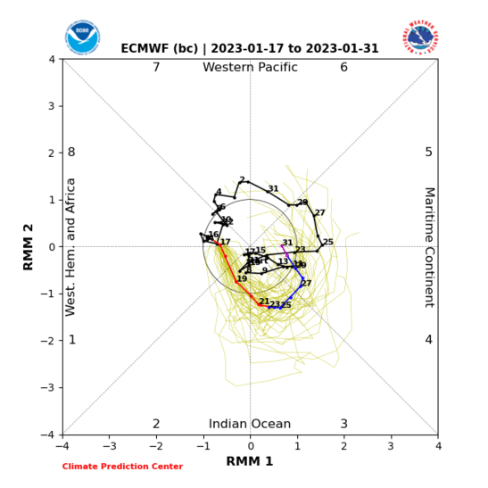
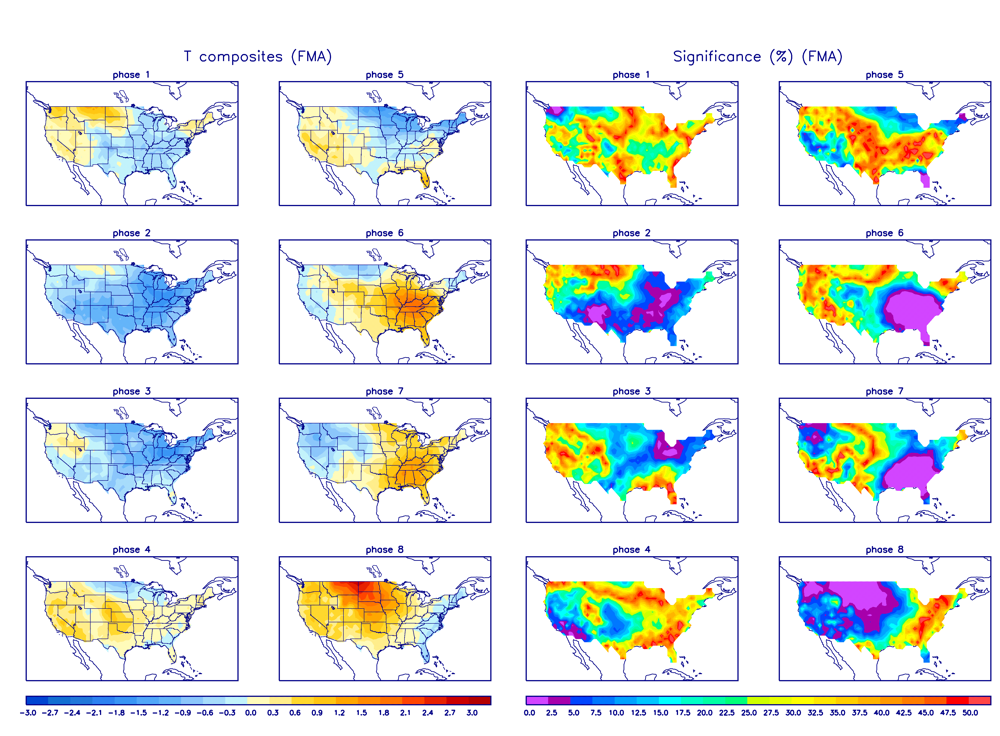
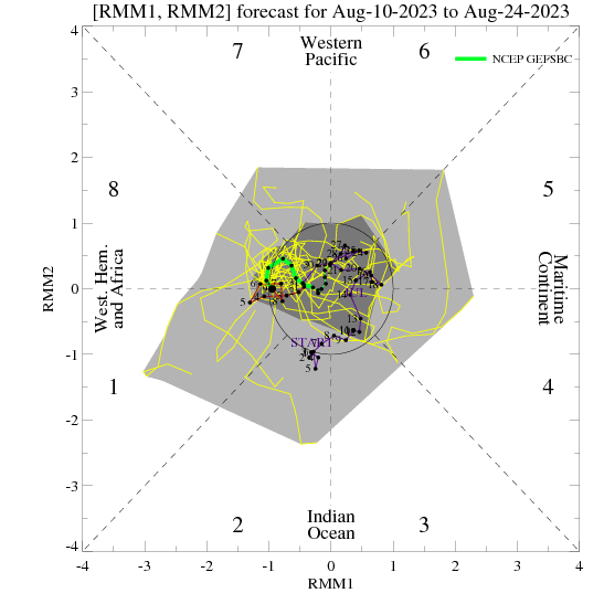
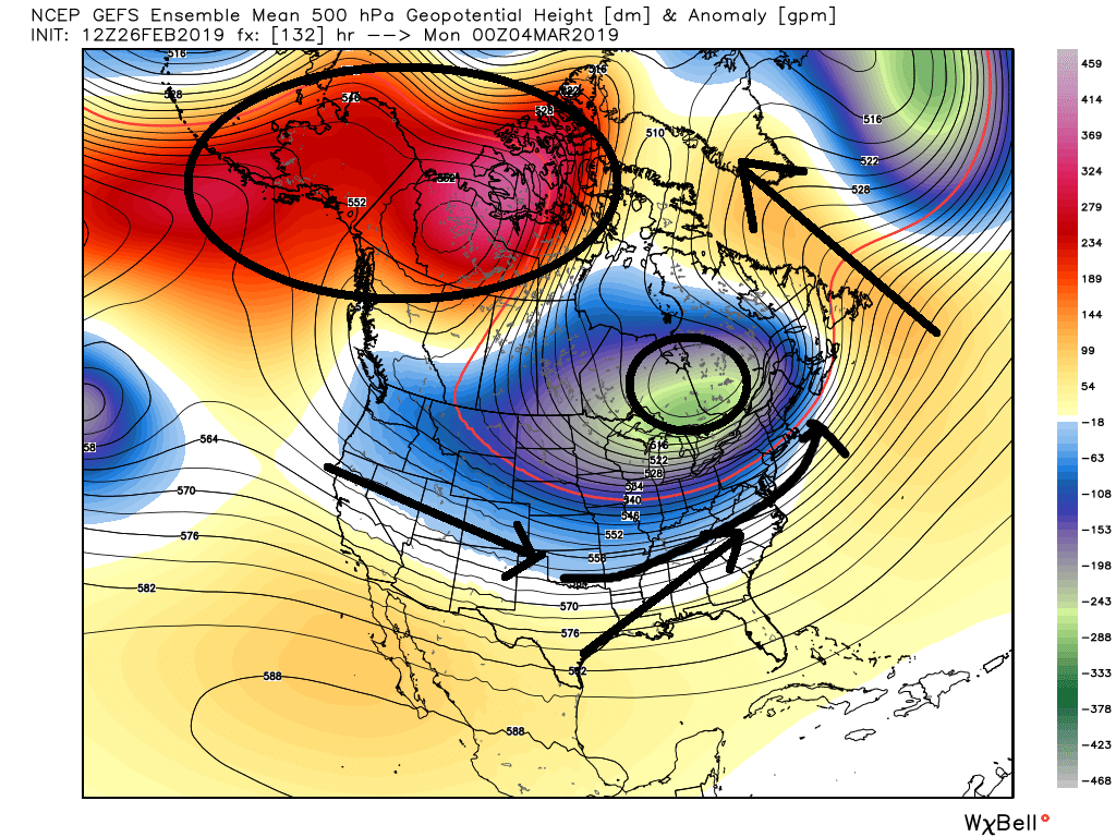
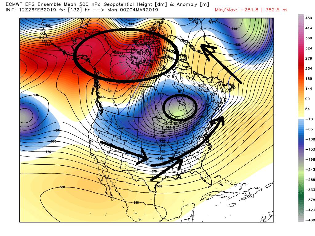
The chain of causality for this event is quite interesting, and ultimately, the tertiary cause of the improvements in track denoted in modelling is a slight/subtle correction toward more geopotential height extension into Greenland downstream, which acts to force the TPV slightly farther south, near the southern tip of Hudson's Bay. Consequently, the short wave itself must follow a pendulum curve farther south than it otherwise would have. The secondary cause is the zonal wind increase in the sub-tropics of the ATL which have aided in this ephemeral pulse of high-latitude blocking; non-canonical, certainly, but it's sufficient and it works. The corrections toward more snowy are not coincidental or luck based for that matter. Of course, the provenance of the sub-tropical zonal wind increase in the Atlantic is the amelioration in tropical forcing, most notably the 7-8 day MJO phase 1 lag which induces these very effects. Concordantly, the chain of causality makes sense meteorologically, and the resultant impact will be the most optimal winter storm scenario of the season to date for much of the I-95 corridor. The MJO will remain conducive for the next 10 days at least as well. Beyond that, the picture becomes more nebulous, but I don't see a blowtorch pattern coming at this juncture, in fact, the Pacific may ameliorate again after a transient interlude, so there may be another final threat (probably minor) in the second half of March.
Nonetheless, short term, I think this event looks quite good for NYC and immediate surroundings.
_________________
Mugs
AKA:King: Snow Weenie
Self Proclaimed
WINTER 2014-15 : 55.12" +.02 for 6 coatings (avg. 35")
WINTER 2015-16 Total - 29.8" (Avg 35")
WINTER 2016-17 : 39.5" so far

amugs- Advanced Forecaster - Mod

- Posts : 15095
Reputation : 213
Join date : 2013-01-07
Age : 54
Location : Hillsdale,NJ
 Re: Sun/Monday March 3rd-4th 2019 Storm
0Z NAM MONEY SHOT


_________________
Mugs
AKA:King: Snow Weenie
Self Proclaimed
WINTER 2014-15 : 55.12" +.02 for 6 coatings (avg. 35")
WINTER 2015-16 Total - 29.8" (Avg 35")
WINTER 2016-17 : 39.5" so far

amugs- Advanced Forecaster - Mod

- Posts : 15095
Reputation : 213
Join date : 2013-01-07
Age : 54
Location : Hillsdale,NJ
 Re: Sun/Monday March 3rd-4th 2019 Storm
Sroc, can you explain to me where i'm whining? I asked a question, gave clarification to my location and then said i wouldn't sign based on projections on the map for my area.
Look forward to your response...
Look forward to your response...

Irish- Pro Enthusiast

- Posts : 788
Reputation : 19
Join date : 2019-01-16
Age : 45
Location : Old Bridge, NJ
 Re: Sun/Monday March 3rd-4th 2019 Storm
amugs wrote:Chillax dude - this isn't the case - one model run doesn't mean this ends at 12AM and it showing 4amish stopping as the storm pulls outjmanley32 wrote:Damn it ends late Sunday night per 3km nam though it snows entire time even for NYC!, plenty time for morning commute so probably schools will be open. Won't even get to enjoy it.
Any way from Isotherm:
The chain of causality for this event is quite interesting, and ultimately, the tertiary cause of the improvements in track denoted in modelling is a slight/subtle correction toward more geopotential height extension into Greenland downstream, which acts to force the TPV slightly farther south, near the southern tip of Hudson's Bay. Consequently, the short wave itself must follow a pendulum curve farther south than it otherwise would have. The secondary cause is the zonal wind increase in the sub-tropics of the ATL which have aided in this ephemeral pulse of high-latitude blocking; non-canonical, certainly, but it's sufficient and it works. The corrections toward more snowy are not coincidental or luck based for that matter. Of course, the provenance of the sub-tropical zonal wind increase in the Atlantic is the amelioration in tropical forcing, most notably the 7-8 day MJO phase 1 lag which induces these very effects. Concordantly, the chain of causality makes sense meteorologically, and the resultant impact will be the most optimal winter storm scenario of the season to date for much of the I-95 corridor. The MJO will remain conducive for the next 10 days at least as well. Beyond that, the picture becomes more nebulous, but I don't see a blowtorch pattern coming at this juncture, in fact, the Pacific may ameliorate again after a transient interlude, so there may be another final threat (probably minor) in the second half of March.
Nonetheless, short term, I think this event looks quite good for NYC and immediate surroundings.
If only Tom had read my write up from Tuesday
sroc4 wrote:crippo84 wrote:sroc4 wrote:crippo84 wrote:One day we hear March will warm up after the first week. The next we hear it's expected to be cold. As this winter has shown, the long range can't really be trusted. Probably best not to speculate too much at this point.
With the MJO doing what its doing expect the next 10-14 days to avg below normal. Confidence level = moderate to high with that statement
And early next week the potential for a significant snowfall exists
Thanks Scott. Always appreciate and trust your guidance. I know many have given up and thrown in the towel, but I can't get over going through winter without one significant snow chance to track. Hoping for the best next week.
You bet and thanks. I myself have thrown in the towel a long time ago, but that doesnt mean we still cant get something to come through. Regardless of how the past has gone one always has to remain objective about the present and future. MJO rounding through cold phases for this time of year(see below). Both GEFS and EURO ens are for the first time in a long time in agreement regarding this. SOI is cooperating.
Side note. I really have not done much in depth analysis of the overall pattern so while I am pretty confident in the BN temps coming up Im not nearly as confident yet about the significant snow threats. That said the look to the pattern on the GFS and Euro ensemble mean makes me think that the blocking into Alaska, but also into NW Canada will force the TPV far enough into SE Canada to prevent anything coming out of the south from cutting. There also seems to be just enough higher heights in the N Atlantic to potentially allow the N and southern streams to phase leading to an actual Nor Eatser type set up here for early next week with this look. I "like" the look, but dont love the look. As per usual timing is everything. Fingers crossed, ice cubes in toilet.
_________________
"In weather and in life, there's no winning and losing; there's only winning and learning."
WINTER 2012/2013 TOTALS 43.65"WINTER 2017/2018 TOTALS 62.85" WINTER 2022/2023 TOTALS 4.9"
WINTER 2013/2014 TOTALS 64.85"WINTER 2018/2019 TOTALS 14.25" WINTER 2023/2024 TOTALS 13.1"
WINTER 2014/2015 TOTALS 71.20"WINTER 2019/2020 TOTALS 6.35"
WINTER 2015/2016 TOTALS 35.00"WINTER 2020/2021 TOTALS 37.75"
WINTER 2016/2017 TOTALS 42.25"WINTER 2021/2022 TOTALS 31.65"

sroc4- Admin

- Posts : 8354
Reputation : 302
Join date : 2013-01-07
Location : Wading River, LI
 Re: Sun/Monday March 3rd-4th 2019 Storm
Irish wrote:Sroc, can you explain to me where i'm whining? I asked a question, gave clarification to my location and then said i wouldn't sign based on projections on the map for my area.
Look forward to your response...
See the Play Pen thread
_________________
"In weather and in life, there's no winning and losing; there's only winning and learning."
WINTER 2012/2013 TOTALS 43.65"WINTER 2017/2018 TOTALS 62.85" WINTER 2022/2023 TOTALS 4.9"
WINTER 2013/2014 TOTALS 64.85"WINTER 2018/2019 TOTALS 14.25" WINTER 2023/2024 TOTALS 13.1"
WINTER 2014/2015 TOTALS 71.20"WINTER 2019/2020 TOTALS 6.35"
WINTER 2015/2016 TOTALS 35.00"WINTER 2020/2021 TOTALS 37.75"
WINTER 2016/2017 TOTALS 42.25"WINTER 2021/2022 TOTALS 31.65"

sroc4- Admin

- Posts : 8354
Reputation : 302
Join date : 2013-01-07
Location : Wading River, LI
 Re: Sun/Monday March 3rd-4th 2019 Storm
Ladies and gentlemen the Euro still continues to correct itself. Latest 0Z is now another tic S&E and my guess is it's not quite done yet. It has not handled this storm properly at all.
heehaw453- Advanced Forecaster

- Posts : 3906
Reputation : 86
Join date : 2014-01-20
Location : Bedminster Township, PA Elevation 600' ASL
 Re: Sun/Monday March 3rd-4th 2019 Storm
So, i gather with the moves s and e, heehaw, that that's great news for a solid snow event?

Irish- Pro Enthusiast

- Posts : 788
Reputation : 19
Join date : 2019-01-16
Age : 45
Location : Old Bridge, NJ
 Re: Sun/Monday March 3rd-4th 2019 Storm
We need to let this current storm get by to get a better handle of exact track. There is not doubt it has shifted SE which bodes well for those close to the I95.
heehaw453- Advanced Forecaster

- Posts : 3906
Reputation : 86
Join date : 2014-01-20
Location : Bedminster Township, PA Elevation 600' ASL
 Re: Sun/Monday March 3rd-4th 2019 Storm
It seems to be coming in line with other models that have had a colder/more SE track all along. I also think tonight’s event (which is giving me heavy snow right now) bodes well for tomorrow nights track.

billg315- Advanced Forecaster - Mod

- Posts : 4483
Reputation : 185
Join date : 2015-01-24
Age : 50
Location : Flemington, NJ
 Re: Sun/Monday March 3rd-4th 2019 Storm
NWS is on board with colder snowier solution. Winter Storm Watch just issued for my area of Central NJ for 4-9” Sunday night into Monday:
WINTER STORM WATCH...Additional snow is anticipated from late Sunday into Monday morning. Snowfall amounts of 4 to 9 inches are possible at that time. Travel may become hazardous. The snow is forecast to impact the Monday morning commute.
PRECAUTIONARY/PREPAREDNESS ACTIONS
This Winter Weather Advisory means that snow will cause travel difficulties. Expect snow covered roads and limited visibility. Use extra caution if driving.
This Winter Storm Watch means that there is potential for
significant snow that may impact travel. Continue to monitor the forecast over the weekend.

billg315- Advanced Forecaster - Mod

- Posts : 4483
Reputation : 185
Join date : 2015-01-24
Age : 50
Location : Flemington, NJ
 Re: Sun/Monday March 3rd-4th 2019 Storm
6z NAMhas good low placement. Keeps everywhere from I-95 corridor and N&W mainly snow. Good 4-10” storm for most folks on here except the Jersey shore and eastern LI. Need a tick S &E to help those folks out here.

billg315- Advanced Forecaster - Mod

- Posts : 4483
Reputation : 185
Join date : 2015-01-24
Age : 50
Location : Flemington, NJ
 Re: Sun/Monday March 3rd-4th 2019 Storm
Gfs models are a bit too far SE imo. I think BM to slightly inside. But we’ll probably know more this evening.
heehaw453- Advanced Forecaster

- Posts : 3906
Reputation : 86
Join date : 2014-01-20
Location : Bedminster Township, PA Elevation 600' ASL
Page 2 of 22 •  1, 2, 3 ... 12 ... 22
Page 2 of 22
Permissions in this forum:
You cannot reply to topics in this forum|
|
|

 Home
Home