
 Search
Sun/Monday March 3rd-4th 2019 Storm
Page 3 of 22 •  1, 2, 3, 4 ... 12 ... 22
 ![]()
Re: Sun/Monday March 3rd-4th 2019 Storm
![]() by billg315 Sat Mar 02, 2019 4:03 am
by billg315 Sat Mar 02, 2019 4:03 am
billg315- Advanced Forecaster - Mod

- Posts : 4483
Join date : 2015-01-24
Re: Sun/Monday March 3rd-4th 2019 Storm
![]() by heehaw453 Sat Mar 02, 2019 5:12 am
by heehaw453 Sat Mar 02, 2019 5:12 am
heehaw453- Advanced Forecaster

- Posts : 3906
Join date : 2014-01-20
Re: Sun/Monday March 3rd-4th 2019 Storm
![]() by skinsfan1177 Sat Mar 02, 2019 6:03 am
by skinsfan1177 Sat Mar 02, 2019 6:03 am


skinsfan1177- Senior Enthusiast

- Posts : 4485
Reputation : 35
Join date : 2013-01-07
Age : 46
Location : Point Pleasant Boro


skinsfan1177- Senior Enthusiast
- Posts : 4485
Reputation : 35
Join date : 2013-01-07
Age : 46
Location : Point Pleasant Boro
Re: Sun/Monday March 3rd-4th 2019 Storm
![]() by jmanley32 Sat Mar 02, 2019 6:45 am
by jmanley32 Sat Mar 02, 2019 6:45 am

jmanley32- Senior Enthusiast
- Posts : 20535
Reputation : 108
Join date : 2013-12-12
Age : 43
Location : Yonkers, NY
Re: Sun/Monday March 3rd-4th 2019 Storm
![]() by CPcantmeasuresnow Sat Mar 02, 2019 6:50 am
by CPcantmeasuresnow Sat Mar 02, 2019 6:50 am
jmanley32 wrote:NAM please!! WSW up for almost everyone, here in NYC metro and CT and westchester 6=8 on sunday into monday! That would put me at about normal for the year believe it or not if you include Nov. if I got 8 I would have roughly 25 inches including all the nickle and dimers and 3 today and 2 yesterday.
If you use the current posted 30 year averages 1981-2010 in NYC it's 25.8 inches. The 150 year average is 28.8 inches and the average since 1991 which will be the starting period for the new 30 year averages is 30.5 inches.
It's most likely an inch or two more in Yonkers, so your normal would be in the 30-32 inch range.

CPcantmeasuresnow- Wx Statistician Guru

- Posts : 7274
Reputation : 230
Join date : 2013-01-07
Age : 103
Location : Eastern Orange County, NY
Re: Sun/Monday March 3rd-4th 2019 Storm
![]() by jmanley32 Sat Mar 02, 2019 7:02 am
by jmanley32 Sat Mar 02, 2019 7:02 am
/O.NEW.KOKX.WS.A.0003.190303T1800Z-190304T1200Z/
/O.CON.KOKX.WW.Y.0010.000000T0000Z-190302T1700Z/
Northern Fairfield-Northern New Haven-Northern Middlesex-
Northern New London-Southern Fairfield-Southern New Haven-
Western Passaic-Eastern Passaic-Western Bergen-Eastern Bergen-
Orange-Putnam-Rockland-Northern Westchester-Southern Westchester-
341 AM EST Sat Mar 2 2019
...WINTER WEATHER ADVISORY REMAINS IN EFFECT UNTIL NOON EST
TODAY...
...WINTER STORM WATCH IN EFFECT FROM SUNDAY AFTERNOON THROUGH
MONDAY MORNING...
* WHAT...Snow today with additional snow accumulations of 2 to 4
inches. Moderate snow Sunday afternoon into Monday morning with
snow accumulations of 5 to 8 inches possible.
* WHERE...Portions of northeastern New Jersey, most of southern
Connecticut and portions of southeastern New York.
* WHEN...For the Winter Weather Advisory, until noon EST today.
For the Winter Storm Watch, from Sunday afternoon through
Monday morning.
jmanley32- Senior Enthusiast
- Posts : 20535
Reputation : 108
Join date : 2013-12-12
Age : 43
Location : Yonkers, NY
Re: Sun/Monday March 3rd-4th 2019 Storm
![]() by jmanley32 Sat Mar 02, 2019 7:03 am
by jmanley32 Sat Mar 02, 2019 7:03 am
Well alot closer than I had imagined, I ended past few years around 30 so been below average then but it's not a lot below.CPcantmeasuresnow wrote:jmanley32 wrote:NAM please!! WSW up for almost everyone, here in NYC metro and CT and westchester 6=8 on sunday into monday! That would put me at about normal for the year believe it or not if you include Nov. if I got 8 I would have roughly 25 inches including all the nickle and dimers and 3 today and 2 yesterday.
If you use the current posted 30 year averages 1981-2010 in NYC it's 25.8 inches. The 150 year average is 28.8 inches and the average since 1991 which will be the starting period for the new 30 year averages is 30.5 inches.
It's most likely an inch or two more in Yonkers, so your normal would be in the 30-32 inch range.
jmanley32- Senior Enthusiast
- Posts : 20535
Reputation : 108
Join date : 2013-12-12
Age : 43
Location : Yonkers, NY
Re: Sun/Monday March 3rd-4th 2019 Storm
![]() by sroc4 Sat Mar 02, 2019 8:43 am
by sroc4 Sat Mar 02, 2019 8:43 am

For those who don't know why Im focused on the jet streak: The 250mb level is approx 34,000ft above sea level. In the image above I intentionally drew a line though the center of the jet streak from SW to NE. Now image the SW side being point A and NE side point B. At point A the air at the level of the atmosphere begins to speed up. As you travel along the line towards point B the speed conts to increase until some center point and then slows again as it approaches point B. So image point A and B separately for a moment. At point B the air is piling up because from the center point of the jet streak to point B the air is going from fast to slow. However, At point A the air molecules are accelerating and racing away towards the center point and point B. SO, when you have a jet streak where you have that air racing away you create an area of "divergence" in a horizontal plane. The air from the lower levels rises up the column vertically in attempt to replace the air molecules that are racing away horizontally(Point A to point B) within the JS. This vertical motion in the atmosphere is where we get "Low Pressure". As we know rising air enhances precipitation. Now where the best vertical motion takes place relative to the position of the jet streak will ALWAYS be found in the right rear quadrant and the Left front Quadrant of a jet streak. To roughly examine where to expect the best lift draw a perpendicular line to the orientation of the JS through the approx. center point of the fastest part of the jet streak. Look at the image above to see the approx. best lift at the surface relative to the euro models positioning the JS
Now back to our forecast. I believe that the S&E trends are truly real here. Why? Several factors. Watching the trends at where the TPV is trying to center itself over the N James bay region instead into the Hudson Bay is one reson. The reason for this has been the trends to our -EPO ridge and the subtle higher heights reaching into the SW Greenland area that appear to be associated with the ULL that forms out over the NA which I outlined in prev discussion(BTW that ULL is compliments of the energy producing the snow we are seeing this morning) The combo is "trapping" the TPV far enough S&E to keep our system far enough S&E. Again subtle differences here over the next 24hrs can have huge implications for specific back yards.

However; At least with respect to our JS both euro GFS and some of the other modeling have been consistent with a JS to our N. That tells me where the track of our system may want to follow as the JS enhances LP development futher S&E relative to where the track of the euro has had the system going(hugging the coast) the last few days. LP tends to want to follolw the path of least resistance. Keep in mind its the energy at 500mb(vorticity) that makes the storm(LP) at the surface, but the JS is an enhancer to the overall rising motion. All this said nothing is set in stone right now, but I truley think the colder soln has legs. Keep in mind the further S&E we go the worse it becomes for N&W. Also if the JS is too far south then the precip shield can only expand so far N&W before you lose the rising motion on the NW flank and enter the dreaded subsidnece zone, again on the NW flank. Anyway that's all for now. Lets see what the models do today.
Guess what???
WE TRACK!!!!!!!!!!!!!!!!!!

Last edited by sroc4 on Sat Mar 02, 2019 9:06 am; edited 3 times in total
_________________
"In weather and in life, there's no winning and losing; there's only winning and learning."
WINTER 2012/2013 TOTALS 43.65"WINTER 2017/2018 TOTALS 62.85" WINTER 2022/2023 TOTALS 4.9"
WINTER 2013/2014 TOTALS 64.85"WINTER 2018/2019 TOTALS 14.25" WINTER 2023/2024 TOTALS 13.1"
WINTER 2014/2015 TOTALS 71.20"WINTER 2019/2020 TOTALS 6.35"
WINTER 2015/2016 TOTALS 35.00"WINTER 2020/2021 TOTALS 37.75"
WINTER 2016/2017 TOTALS 42.25"WINTER 2021/2022 TOTALS 31.65"

sroc4- Admin

- Posts : 8354
Reputation : 302
Join date : 2013-01-07
Location : Wading River, LI
Re: Sun/Monday March 3rd-4th 2019 Storm
![]() by mwilli Sat Mar 02, 2019 8:54 am
by mwilli Sat Mar 02, 2019 8:54 am
mwilli- Posts : 132
Reputation : 3
Join date : 2019-02-11
Re: Sun/Monday March 3rd-4th 2019 Storm
![]() by heehaw453 Sat Mar 02, 2019 8:56 am
by heehaw453 Sat Mar 02, 2019 8:56 am
But let's see how things look when the energy is sampled today.
heehaw453- Advanced Forecaster
- Posts : 3906
Reputation : 86
Join date : 2014-01-20
Location : Bedminster Township, PA Elevation 600' ASL
Re: Sun/Monday March 3rd-4th 2019 Storm
![]() by amugs Sat Mar 02, 2019 9:03 am
by amugs Sat Mar 02, 2019 9:03 am
SE bias in the suite.heehaw453 wrote:Gfs models are a bit too far SE imo. I think BM to slightly inside. But we’ll probably know more this evening.
6Z Euro caved things are looking good for a trifecta of storms. Big Momma balancing things out.
Scott yes great work as usual.
_________________
Mugs
AKA:King: Snow Weenie
Self Proclaimed
WINTER 2014-15 : 55.12" +.02 for 6 coatings (avg. 35")
WINTER 2015-16 Total - 29.8" (Avg 35")
WINTER 2016-17 : 39.5" so far

amugs- Advanced Forecaster - Mod
- Posts : 15095
Reputation : 213
Join date : 2013-01-07
Age : 54
Location : Hillsdale,NJ
Re: Sun/Monday March 3rd-4th 2019 Storm
![]() by amugs Sat Mar 02, 2019 9:07 am
by amugs Sat Mar 02, 2019 9:07 am
Last edited by amugs on Sat Mar 02, 2019 9:08 am; edited 1 time in total
_________________
Mugs
AKA:King: Snow Weenie
Self Proclaimed
WINTER 2014-15 : 55.12" +.02 for 6 coatings (avg. 35")
WINTER 2015-16 Total - 29.8" (Avg 35")
WINTER 2016-17 : 39.5" so far
amugs- Advanced Forecaster - Mod
- Posts : 15095
Reputation : 213
Join date : 2013-01-07
Age : 54
Location : Hillsdale,NJ
Re: Sun/Monday March 3rd-4th 2019 Storm
![]() by sroc4 Sat Mar 02, 2019 9:08 am
by sroc4 Sat Mar 02, 2019 9:08 am
sroc4 wrote:So a quick update for Sunday into Monday system. I want to focus on the jet streak at approx 250mb
For those who don't know why Im focused on the jet streak: The 250mb level is approx 34,000ft above sea level. In the image above I intentionally drew a line though the center of the jet streak from SW to NE. Now image the SW side being point A and NE side point B. At point A the air at the level of the atmosphere begins to speed up. As you travel along the line towards point B the speed conts to increase until some center point and then slows again as it approaches point B. So image point A and B separately for a moment. At point B the air is piling up because from the center point of the jet streak to point B the air is going from fast to slow. However, At point A the air molecules are accelerating and racing away towards the center point and point B. SO, when you have a jet streak where you have that air racing away you create an area of "divergence" in a horizontal plane. The air from the lower levels rises up the column vertically in attempt to replace the air molecules that are racing away horizontally(Point A to point B) within the JS. This vertical motion in the atmosphere is where we get "Low Pressure". As we know rising air enhances precipitation. Now where the best vertical motion takes place relative to the position of the jet streak will ALWAYS be found in the right rear quadrant and the Left front Quadrant of a jet streak. To roughly examine where to expect the best lift draw a perpendicular line to the orientation of the JS through the approx. center point of the fastest part of the jet streak. Look at the image above to see the approx. best lift at the surface relative to the euro models positioning the JS
Now back to our forecast. I believe that the S&E trends are truly real here. Why? Several factors. Watching the trends at where the TPV is trying to center itself over the N James bay region instead into the Hudson Bay is one reson. The reason for this has been the trends to our -EPO ridge and the subtle higher heights reaching into the SW Greenland area that appear to be associated with the ULL that forms out over the NA which I outlined in prev discussion(BTW that ULL is compliments of the energy producing the snow we are seeing this morning) The combo is "trapping" the TPV far enough S&E to keep our system far enough S&E. Again subtle differences here over the next 24hrs can have huge implications for specific back yards.
However; At least with respect to our JS both euro GFS and some of the other modeling have been consistent with a JS to our N. That tells me where the track of our system may want to follow as the JS enhances LP development futher S&E relative to where the track of the euro has had the system going(hugging the coast) the last few days. LP tends to want to follolw the path of least resistance. Keep in mind its the energy at 500mb(vorticity) that makes the storm(LP) at the surface, but the JS is an enhancer to the overall rising motion. All this said nothing is set in stone right now, but I truley think the colder soln has legs. Keep in mind the further S&E we go the worse it becomes for N&W. Also if the JS is too far south then the precip shield can only expand so far N&W before you lose the rising motion on the NW flank and enter the dreaded subsidnece zone, again on the NW flank. Anyway that's all for now. Lets see what the models do today.
Guess what???
WE TRACK!!!!!!!!!!!!!!!!!!
BTW for those who have read this already I edited it because I realized that the prev discussion regarding the Jet Streak was involving todays snow enhancement; however it still applies for Sunday/Monday. I added an additional map and some discussion from what I posted a little while ago. Sorry for the confusion.
_________________
"In weather and in life, there's no winning and losing; there's only winning and learning."
WINTER 2012/2013 TOTALS 43.65"WINTER 2017/2018 TOTALS 62.85" WINTER 2022/2023 TOTALS 4.9"
WINTER 2013/2014 TOTALS 64.85"WINTER 2018/2019 TOTALS 14.25" WINTER 2023/2024 TOTALS 13.1"
WINTER 2014/2015 TOTALS 71.20"WINTER 2019/2020 TOTALS 6.35"
WINTER 2015/2016 TOTALS 35.00"WINTER 2020/2021 TOTALS 37.75"
WINTER 2016/2017 TOTALS 42.25"WINTER 2021/2022 TOTALS 31.65"
sroc4- Admin
- Posts : 8354
Reputation : 302
Join date : 2013-01-07
Location : Wading River, LI
Re: Sun/Monday March 3rd-4th 2019 Storm
![]() by sroc4 Sat Mar 02, 2019 9:12 am
by sroc4 Sat Mar 02, 2019 9:12 am
amugs wrote:Today's storm is key to how the next storm.plays out Channel 7 goes Ballas to walls this morning with their snowfall forecast. Bit surprised but can see this potential if things align.
What did they say? Last night I was rolling my eyes a bit at Lee Goldberg when he said without hesitation or without a CYA that only N&W of the I-95 was going to see snow. The coast would see wintry mix and or rain and little to no accumulation. I usually trust Lee but last night by the 11pm broadcast I know he saw the trends and didn't say boo. I would have thought he would have at least said models have trended a little colder and further S&E so the morning/eekend team may have updates if the trneds cont. He usually does that.
_________________
"In weather and in life, there's no winning and losing; there's only winning and learning."
WINTER 2012/2013 TOTALS 43.65"WINTER 2017/2018 TOTALS 62.85" WINTER 2022/2023 TOTALS 4.9"
WINTER 2013/2014 TOTALS 64.85"WINTER 2018/2019 TOTALS 14.25" WINTER 2023/2024 TOTALS 13.1"
WINTER 2014/2015 TOTALS 71.20"WINTER 2019/2020 TOTALS 6.35"
WINTER 2015/2016 TOTALS 35.00"WINTER 2020/2021 TOTALS 37.75"
WINTER 2016/2017 TOTALS 42.25"WINTER 2021/2022 TOTALS 31.65"
sroc4- Admin
- Posts : 8354
Reputation : 302
Join date : 2013-01-07
Location : Wading River, LI
Re: Sun/Monday March 3rd-4th 2019 Storm
![]() by amugs Sat Mar 02, 2019 9:30 am
by amugs Sat Mar 02, 2019 9:30 am
sroc4 wrote:amugs wrote:Today's storm is key to how the next storm.plays out Channel 7 goes Ballas to walls this morning with their snowfall forecast. Bit surprised but can see this potential if things align.
What did they say? Last night I was rolling my eyes a bit at Lee Goldberg when he said without hesitation or without a CYA that only N&W of the I-95 was going to see snow. The coast would see wintry mix and or rain and little to no accumulation. I usually trust Lee but last night by the 11pm broadcast I know he saw the trends and didn't say boo. I would have thought he would have at least said models have trended a little colder and further S&E so the morning/eekend team may have updates if the trneds cont. He usually does that. [/quote
Amy just bitch slapped Lee and said snap out of it and went with this WOWZA!!
_________________
Mugs
AKA:King: Snow Weenie
Self Proclaimed
WINTER 2014-15 : 55.12" +.02 for 6 coatings (avg. 35")
WINTER 2015-16 Total - 29.8" (Avg 35")
WINTER 2016-17 : 39.5" so far
amugs- Advanced Forecaster - Mod
- Posts : 15095
Reputation : 213
Join date : 2013-01-07
Age : 54
Location : Hillsdale,NJ
Re: Sun/Monday March 3rd-4th 2019 Storm
![]() by heehaw453 Sat Mar 02, 2019 9:35 am
by heehaw453 Sat Mar 02, 2019 9:35 am
heehaw453- Advanced Forecaster
- Posts : 3906
Reputation : 86
Join date : 2014-01-20
Location : Bedminster Township, PA Elevation 600' ASL
Re: Sun/Monday March 3rd-4th 2019 Storm
![]() by nutleyblizzard Sat Mar 02, 2019 9:37 am
by nutleyblizzard Sat Mar 02, 2019 9:37 am
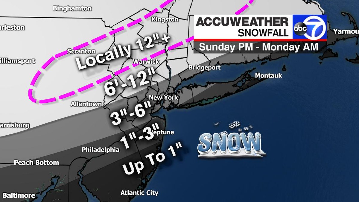
That snow map is incorrect. With all the models trending colder that 6-12 zone needs to be shifted 50 miles SE to cover the city / northern and central Jersey.amugs wrote:sroc4 wrote:amugs wrote:Today's storm is key to how the next storm.plays out Channel 7 goes Ballas to walls this morning with their snowfall forecast. Bit surprised but can see this potential if things align.
What did they say? Last night I was rolling my eyes a bit at Lee Goldberg when he said without hesitation or without a CYA that only N&W of the I-95 was going to see snow. The coast would see wintry mix and or rain and little to no accumulation. I usually trust Lee but last night by the 11pm broadcast I know he saw the trends and didn't say boo. I would have thought he would have at least said models have trended a little colder and further S&E so the morning/eekend team may have updates if the trneds cont. He usually does that. [/quote
Amy just bitch slapped Lee and said snap out of it and went with this WOWZA!!

nutleyblizzard- Senior Enthusiast
- Posts : 1954
Reputation : 41
Join date : 2014-01-30
Age : 58
Location : Nutley, new jersey
Re: Sun/Monday March 3rd-4th 2019 Storm
![]() by jmanley32 Sat Mar 02, 2019 9:42 am
by jmanley32 Sat Mar 02, 2019 9:42 am
anyway that 6 to 12 gets down to city?amugs wrote:sroc4 wrote:amugs wrote:Today's storm is key to how the next storm.plays out Channel 7 goes Ballas to walls this morning with their snowfall forecast. Bit surprised but can see this potential if things align.
What did they say? Last night I was rolling my eyes a bit at Lee Goldberg when he said without hesitation or without a CYA that only N&W of the I-95 was going to see snow. The coast would see wintry mix and or rain and little to no accumulation. I usually trust Lee but last night by the 11pm broadcast I know he saw the trends and didn't say boo. I would have thought he would have at least said models have trended a little colder and further S&E so the morning/eekend team may have updates if the trneds cont. He usually does that. [/quote
Amy just bitch slapped Lee and said snap out of it and went with this WOWZA!!
jmanley32- Senior Enthusiast
- Posts : 20535
Reputation : 108
Join date : 2013-12-12
Age : 43
Location : Yonkers, NY
Re: Sun/Monday March 3rd-4th 2019 Storm
![]() by jmanley32 Sat Mar 02, 2019 9:43 am
by jmanley32 Sat Mar 02, 2019 9:43 am
dang u answered me while I was asking lolnutleyblizzard wrote:That snow map is incorrect. With all the models trending colder that 6-12 zone needs to be shifted 50 miles SE to cover the city / northern and central Jersey.amugs wrote:sroc4 wrote:amugs wrote:Today's storm is key to how the next storm.plays out Channel 7 goes Ballas to walls this morning with their snowfall forecast. Bit surprised but can see this potential if things align.
What did they say? Last night I was rolling my eyes a bit at Lee Goldberg when he said without hesitation or without a CYA that only N&W of the I-95 was going to see snow. The coast would see wintry mix and or rain and little to no accumulation. I usually trust Lee but last night by the 11pm broadcast I know he saw the trends and didn't say boo. I would have thought he would have at least said models have trended a little colder and further S&E so the morning/eekend team may have updates if the trneds cont. He usually does that. [/quote
Amy just bitch slapped Lee and said snap out of it and went with this WOWZA!!
jmanley32- Senior Enthusiast
- Posts : 20535
Reputation : 108
Join date : 2013-12-12
Age : 43
Location : Yonkers, NY
Re: Sun/Monday March 3rd-4th 2019 Storm
![]() by Frank_Wx Sat Mar 02, 2019 9:47 am
by Frank_Wx Sat Mar 02, 2019 9:47 am
Unfortunately, I do think those south of CNJ and parts of the Jersey Shore will flip to rain at some point. I'm having a tough time figuring out how FAR south though. Maybe just the Cape May area, or as far north as Point Pleasant? My preliminary snow map (Figure 3.0) shown below tries to take that into consideration. What you will also see in the images below are the temperatures. The 850mb/925mb are expected to be cold for this system. However, the surface temps look like they will be above freezing for some. You can see how the surface temps are in the upper 30's to low 40's for parts of the area which is why I'm hesitant of higher snow amounts there.
By looking at the 500mb set-up it's easy to see where the dynamics will come from. The coastal low associated with the southern stream is riding the SE Ridge (Figure 4.0), while the PV lobe sits just north of the Great Lakes pressing the trough S&E. The trough and confluent energy at 500mb is preventing this coastal storm from cutting to our west. However, there will not be a phase with northern stream energy. Its purely southern stream driven. This is the main reason why an organized coastal storm with a well defined center will not form. Nevertheless, it will be a fun event because of the dynamics.
Because of this 500mb set-up, upward motion (measured at 700mb) should be impressive. The VV (vertical velocity) maps prove it indeed is depending on the model you look at. The GFS (Figure 5.0) has +2 to +10 VV's throughout the area. Snowfall rates will not be too crazy but moderate enough. Meanwhile, the NAM (Figures 6.0 & 7.0), shows very impressive VV's that could result in 1"+/hour snowfall rates. But notice how the VV's are more concentrated here than they are widespread like the GFS. The greatest VV's tend to be closer to the baroclinic zone.
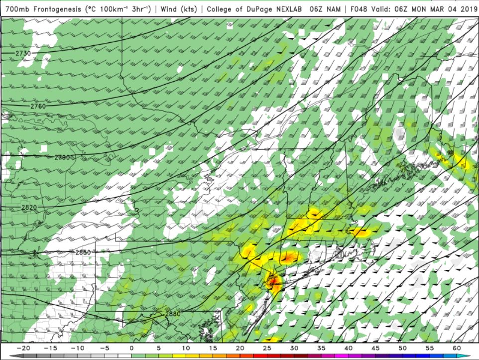
700mb frontogenesis is where you'll find a deformation band try to set-up. Your best lift and snow growth, often where best snowfall rates occur also, is found here. The NAM (Figure 8.0) does show some moderate frontogenesis for NYC and N&W. There could be a period of very heavy snow that falls overnight Sunday or early Monday morning, easily dropping a few inches in just a couple of hours.
Figure 3.0
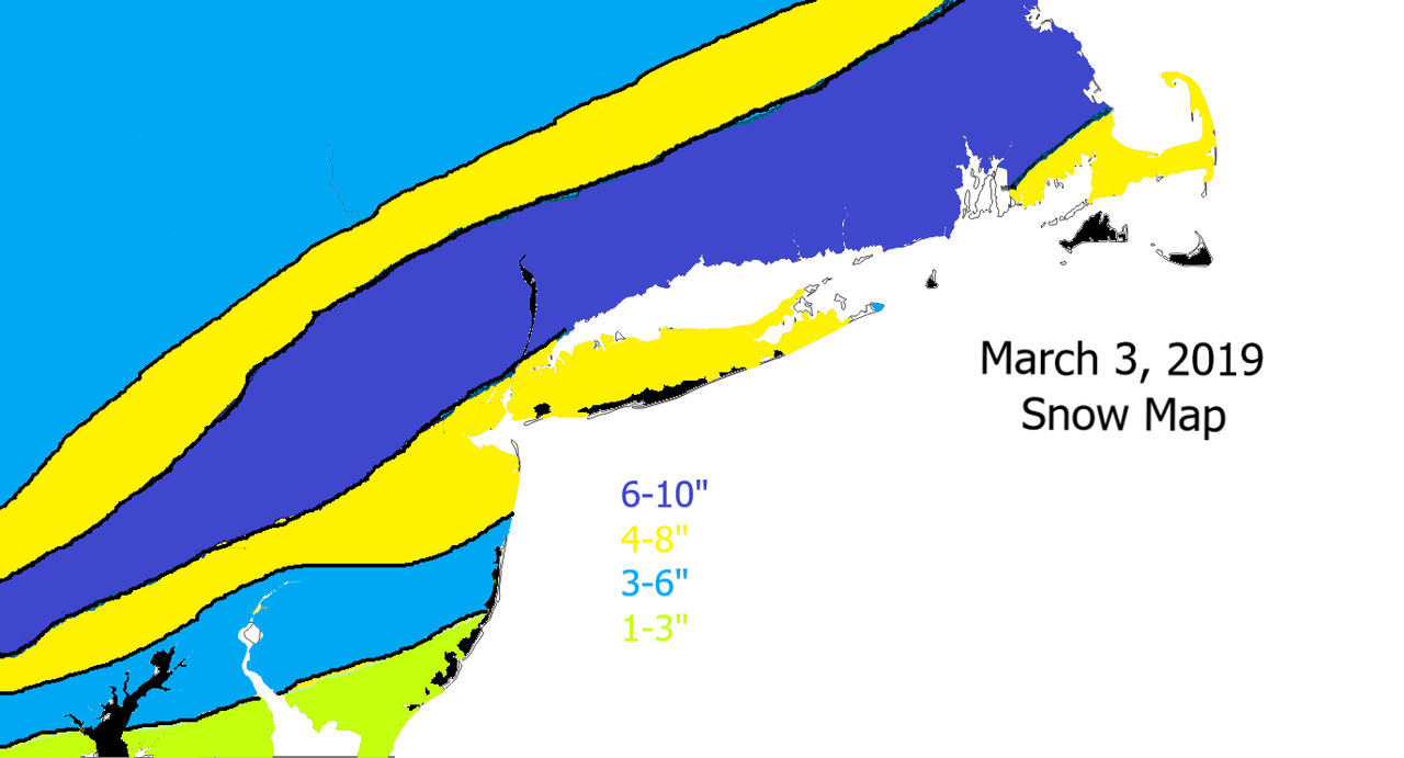
Figure 4.0

Figure 5.0
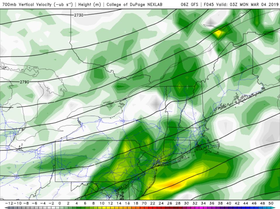
Figure 6.0 & 7.0
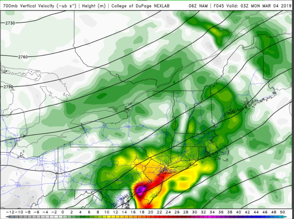
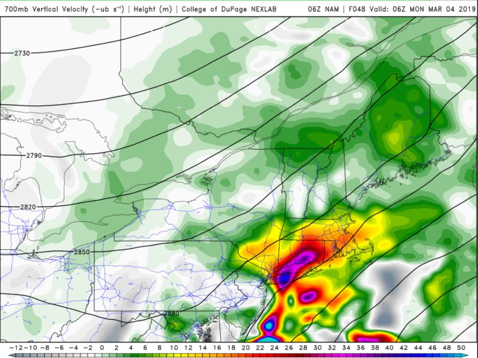
Figure 8.0
_________________
_______________________________________________________________________________________________________
CLICK HERE to view NJ Strong Snowstorm Classifications

Frank_Wx- Godzilla Seeker
- Posts : 21305
Reputation : 328
Join date : 2013-01-05
Age : 32
Location : Jersey City, NJ -

Re: Sun/Monday March 3rd-4th 2019 Storm
![]() by nutleyblizzard Sat Mar 02, 2019 9:51 am
by nutleyblizzard Sat Mar 02, 2019 9:51 am
The latest Nam has Philadelphia getting 6+ inches. That map only shows 1-3??? I would think that map will be updated accordingly later on if the rest of the 12z suite follows suit.jmanley32 wrote:anyway that 6 to 12 gets down to city?amugs wrote:sroc4 wrote:amugs wrote:Today's storm is key to how the next storm.plays out Channel 7 goes Ballas to walls this morning with their snowfall forecast. Bit surprised but can see this potential if things align.
What did they say? Last night I was rolling my eyes a bit at Lee Goldberg when he said without hesitation or without a CYA that only N&W of the I-95 was going to see snow. The coast would see wintry mix and or rain and little to no accumulation. I usually trust Lee but last night by the 11pm broadcast I know he saw the trends and didn't say boo. I would have thought he would have at least said models have trended a little colder and further S&E so the morning/eekend team may have updates if the trneds cont. He usually does that. [/quote
Amy just bitch slapped Lee and said snap out of it and went with this WOWZA!!
nutleyblizzard- Senior Enthusiast
- Posts : 1954
Reputation : 41
Join date : 2014-01-30
Age : 58
Location : Nutley, new jersey
Re: Sun/Monday March 3rd-4th 2019 Storm
![]() by amugs Sat Mar 02, 2019 9:56 am
by amugs Sat Mar 02, 2019 9:56 am
Take this map to the bank................
Thanks Frank and yes I believe the 6-10" is the ceiling of this storm since there is no well defined center and true Nor'easter element
_________________
Mugs
AKA:King: Snow Weenie
Self Proclaimed
WINTER 2014-15 : 55.12" +.02 for 6 coatings (avg. 35")
WINTER 2015-16 Total - 29.8" (Avg 35")
WINTER 2016-17 : 39.5" so far
amugs- Advanced Forecaster - Mod
- Posts : 15095
Reputation : 213
Join date : 2013-01-07
Age : 54
Location : Hillsdale,NJ
Re: Sun/Monday March 3rd-4th 2019 Storm
![]() by billg315 Sat Mar 02, 2019 9:57 am
by billg315 Sat Mar 02, 2019 9:57 am

billg315- Advanced Forecaster - Mod
- Posts : 4483
Reputation : 185
Join date : 2015-01-24
Age : 50
Location : Flemington, NJ
Re: Sun/Monday March 3rd-4th 2019 Storm
![]() by billg315 Sat Mar 02, 2019 10:00 am
by billg315 Sat Mar 02, 2019 10:00 am
billg315- Advanced Forecaster - Mod
- Posts : 4483
Reputation : 185
Join date : 2015-01-24
Age : 50
Location : Flemington, NJ
Re: Sun/Monday March 3rd-4th 2019 Storm
![]() by jmanley32 Sat Mar 02, 2019 10:02 am
by jmanley32 Sat Mar 02, 2019 10:02 am
jmanley32- Senior Enthusiast
- Posts : 20535
Reputation : 108
Join date : 2013-12-12
Age : 43
Location : Yonkers, NY
Re: Sun/Monday March 3rd-4th 2019 Storm
![]() by jmanley32 Sat Mar 02, 2019 10:03 am
by jmanley32 Sat Mar 02, 2019 10:03 am
Last edited by jmanley32 on Sat Mar 02, 2019 10:05 am; edited 1 time in total
jmanley32- Senior Enthusiast
- Posts : 20535
Reputation : 108
Join date : 2013-12-12
Age : 43
Location : Yonkers, NY
Page 3 of 22 • 1, 2, 3, 4 ... 12 ... 22 ![]()
|
|
|