Sun/Monday March 3rd-4th 2019 Storm
+53
justdrew
ak926
Smarnold
Snow88
sabamfa
crippo84
SoulSingMG
snowlover78
oldtimer
Artechmetals
essexcountypete
GreyBeard
marin1804
aiannone
lglickman1
Vinnydula
Artingerb
brownie
kalleg
DAYBLAZER
Dunnzoo
Fededle22
Grselig
Dtone
Math23x7
Scullybutcher
bobjohnsonforthehall
Radz
docstox12
Brookster
larryrock72
Zhukov1945
SENJsnowman
dkodgis
Joe Snow
WeatherBob
RJB8525
Frank_Wx
CPcantmeasuresnow
skinsfan1177
sroc4
Irish
mwilli
hyde345
jmanley32
algae888
nutleyblizzard
Sanchize06
frank 638
weatherwatchermom
billg315
heehaw453
amugs
57 posters
Page 1 of 22
Page 1 of 22 • 1, 2, 3 ... 11 ... 22 
 Sun/Monday March 3rd-4th 2019 Storm
GO!!
_________________
Mugs
AKA:King: Snow Weenie
Self Proclaimed
WINTER 2014-15 : 55.12" +.02 for 6 coatings (avg. 35")
WINTER 2015-16 Total - 29.8" (Avg 35")
WINTER 2016-17 : 39.5" so far

amugs- Advanced Forecaster - Mod

- Posts : 15095
Reputation : 213
Join date : 2013-01-07
Age : 54
Location : Hillsdale,NJ
 Re: Sun/Monday March 3rd-4th 2019 Storm
I'll move this over here.
Rayno had a good explanation on the differences in track for Sunday's storm. It comes down to where the models show the storm energy. Euro is farther west and GFS is farther east off OBX. The TPV is honestly close in position for both models.
How tonight's storm dampens heights on the EC will play a part in the exact track. I have said i like NW of 95 for best snows and continue to do so. My guess is the track will be somewhere between GFS and Euro ultimately and i think that plays well for 95. The other thing i believe is there is a lot of arctic air feeding the back side of this storm. I think that will also help with temperatures.
If someone is lucky enough to stay all snow for this, then 1' amounts are possible. There is enough precip to support it.
heehaw453- Advanced Forecaster

- Posts : 3906
Reputation : 86
Join date : 2014-01-20
Location : Bedminster Township, PA Elevation 600' ASL
 Re: Sun/Monday March 3rd-4th 2019 Storm
DEEP THUNDER SAYS BOOM to I 78 N
NYC Close Call
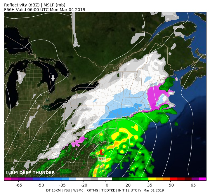
NYC Close Call

_________________
Mugs
AKA:King: Snow Weenie
Self Proclaimed
WINTER 2014-15 : 55.12" +.02 for 6 coatings (avg. 35")
WINTER 2015-16 Total - 29.8" (Avg 35")
WINTER 2016-17 : 39.5" so far

amugs- Advanced Forecaster - Mod

- Posts : 15095
Reputation : 213
Join date : 2013-01-07
Age : 54
Location : Hillsdale,NJ
 Re: Sun/Monday March 3rd-4th 2019 Storm
EPS - tucked look here coast would mix and become a slop storm - possible and we have to see what Saturday storm does. Lots of time for adjustments and the slightest ones have big implications.


_________________
Mugs
AKA:King: Snow Weenie
Self Proclaimed
WINTER 2014-15 : 55.12" +.02 for 6 coatings (avg. 35")
WINTER 2015-16 Total - 29.8" (Avg 35")
WINTER 2016-17 : 39.5" so far

amugs- Advanced Forecaster - Mod

- Posts : 15095
Reputation : 213
Join date : 2013-01-07
Age : 54
Location : Hillsdale,NJ
 Re: Sun/Monday March 3rd-4th 2019 Storm
I may be a fool to believe. But I really think this is more snow than rain for most people from I-95 north and west, including the immediate NYC area and close N&W burbs. I do think the Jersey Shore and southern/eastern Long Island could see a fair amount of rain/sleet mixed in.
I think this has the hallmarks of a storm that starts as snow, maybe briefly mixes with sleet and rain mid-storm, but then quickly goes back to all snow before pulling away to the northeast. I think there will be plenty of cold air pouring in on the backside, I think we will remain on the backside as it stays off the coast.
I think this has the hallmarks of a storm that starts as snow, maybe briefly mixes with sleet and rain mid-storm, but then quickly goes back to all snow before pulling away to the northeast. I think there will be plenty of cold air pouring in on the backside, I think we will remain on the backside as it stays off the coast.

billg315- Advanced Forecaster - Mod

- Posts : 4483
Reputation : 185
Join date : 2015-01-24
Age : 50
Location : Flemington, NJ
 Re: Sun/Monday March 3rd-4th 2019 Storm
18Z 12K NAM track. I track like this with rapid intensification gives mostly snow to 95 and points NW IMO. The more immediate coast would have issues for sure with taint. I believe this may be accurate when all is said and done. This is about 50 miles east of Euro I think, but it's that kind thing here. Exact track is critical, but our storm tonight may just save us with lowering the heights ahead of the storm. Otherwise, I think it'd track much closer if not on top of us.
BTW this is a crushing for 95 points NW.
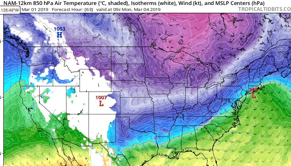
BTW this is a crushing for 95 points NW.

heehaw453- Advanced Forecaster

- Posts : 3906
Reputation : 86
Join date : 2014-01-20
Location : Bedminster Township, PA Elevation 600' ASL
 Re: Sun/Monday March 3rd-4th 2019 Storm
right..we need it to track slightly more east and not on top of us to all have snow right??...and that darn rain snow line is right thru my town..arrrrrr..heehaw453 wrote:18Z 12K NAM track. I track like this with rapid intensification gives mostly snow to 95 and points NW IMO. The more immediate coast would have issues for sure with taint. I believe this may be accurate when all is said and done. This is about 50 miles east of Euro I think, but it's that kind thing here. Exact track is critical, but our storm tonight may just save us with lowering the heights ahead of the storm. Otherwise, I think it'd track much closer if not on top of us.
BTW this is a crushing for 95 points NW.

weatherwatchermom- Senior Enthusiast

- Posts : 3793
Reputation : 78
Join date : 2014-11-25
Location : Hazlet Township, NJ
 Re: Sun/Monday March 3rd-4th 2019 Storm
So far Lee Goldberg has three 6 in of snow with afoot north and west of the city hopefully the foot of snow will come down city and coast
frank 638- Senior Enthusiast

- Posts : 2843
Reputation : 37
Join date : 2016-01-01
Age : 40
Location : bronx ny
 Re: Sun/Monday March 3rd-4th 2019 Storm
18z GFS slightly east of 12z. Looks good for those along the coast as far as mixing goes
Sanchize06- Senior Enthusiast

- Posts : 1041
Reputation : 21
Join date : 2013-02-05
Location : Union Beach, NJ
 Re: Sun/Monday March 3rd-4th 2019 Storm
Scenario #1 by EURO
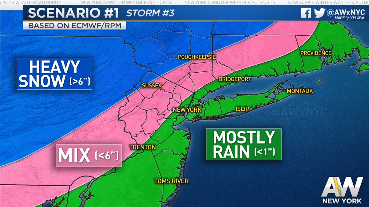
GFS - be friggin right you .. and I will sacrifice my ...........
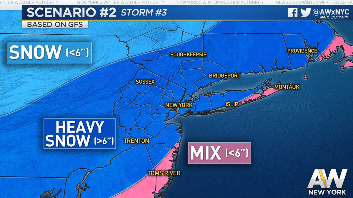

GFS - be friggin right you .. and I will sacrifice my ...........


_________________
Mugs
AKA:King: Snow Weenie
Self Proclaimed
WINTER 2014-15 : 55.12" +.02 for 6 coatings (avg. 35")
WINTER 2015-16 Total - 29.8" (Avg 35")
WINTER 2016-17 : 39.5" so far

amugs- Advanced Forecaster - Mod

- Posts : 15095
Reputation : 213
Join date : 2013-01-07
Age : 54
Location : Hillsdale,NJ
 Re: Sun/Monday March 3rd-4th 2019 Storm
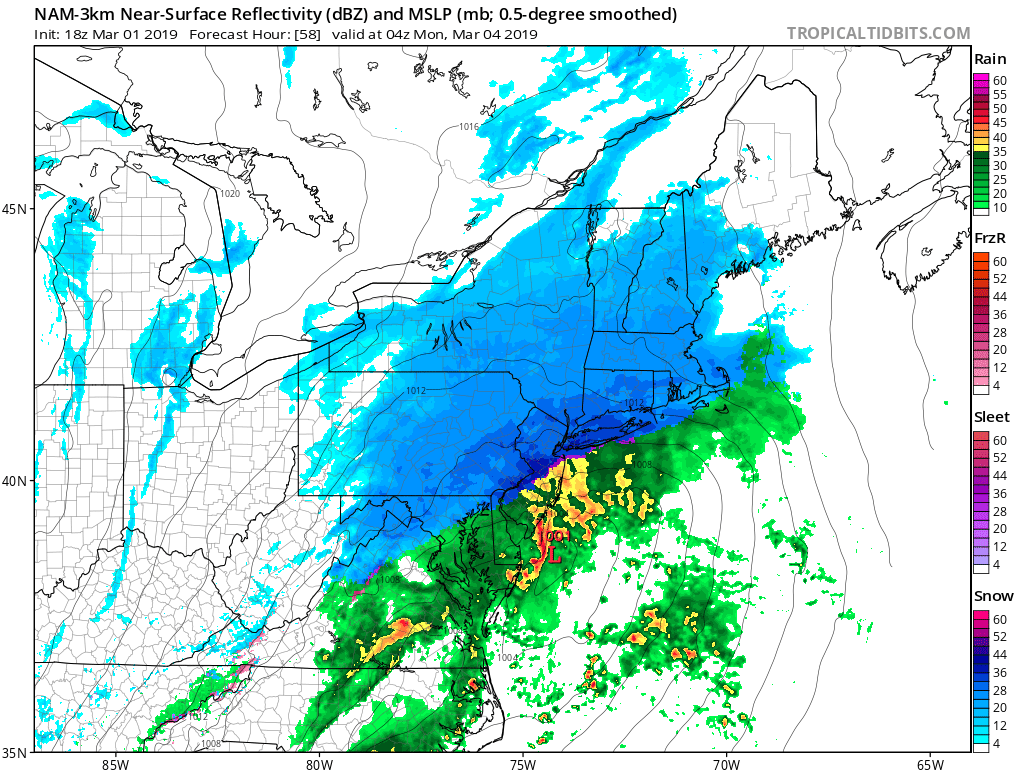
BING IT HI RES NAM

_________________
Mugs
AKA:King: Snow Weenie
Self Proclaimed
WINTER 2014-15 : 55.12" +.02 for 6 coatings (avg. 35")
WINTER 2015-16 Total - 29.8" (Avg 35")
WINTER 2016-17 : 39.5" so far

amugs- Advanced Forecaster - Mod

- Posts : 15095
Reputation : 213
Join date : 2013-01-07
Age : 54
Location : Hillsdale,NJ
 Re: Sun/Monday March 3rd-4th 2019 Storm
18z GEFS remain east, slightly more than 12z


Sanchize06- Senior Enthusiast

- Posts : 1041
Reputation : 21
Join date : 2013-02-05
Location : Union Beach, NJ
 Re: Sun/Monday March 3rd-4th 2019 Storm
Benchmark track. I'd be surprised if the EURO doesn't cave tonight. Progressive flow argues against a hugger track.Sanchize06 wrote:18z GEFS remain east, slightly more than 12z

nutleyblizzard- Senior Enthusiast

- Posts : 1954
Reputation : 41
Join date : 2014-01-30
Age : 58
Location : Nutley, new jersey
 Re: Sun/Monday March 3rd-4th 2019 Storm
The Euro has already caved at 18z 4 millibars weaker low-pressure east of Nantucket instead of over the cape and mugs the Euro solution was never an all rain solution. 4 in of snow before the flip to rain for New York City metro on the 12z 1 don't have the details to the 18z yetnutleyblizzard wrote:Benchmark track. I'd be surprised if the EURO doesn't cave tonight. Progressive flow argues against a hugger track.Sanchize06 wrote:18z GEFS remain east, slightly more than 12z

algae888- Advanced Forecaster

- Posts : 5311
Reputation : 46
Join date : 2013-02-05
Age : 62
Location : mt. vernon, new york
 Re: Sun/Monday March 3rd-4th 2019 Storm
EURO takes the low from off of Cape May to off the Del Marva - BM track and more SE and colder run with lots of STJ moisture to pullalgae888 wrote:The Euro has already caved at 18z 4 millibars weaker low-pressure east of Nantucket instead of over the cape and mugs the Euro solution was never an all rain solution. 4 in of snow before the flip to rain for New York City metro on the 12z 1 don't have the details to the 18z yetnutleyblizzard wrote:Benchmark track. I'd be surprised if the EURO doesn't cave tonight. Progressive flow argues against a hugger track.Sanchize06 wrote:18z GEFS remain east, slightly more than 12z
From 33& Rain look at12Z to 18Z NICE!!!

_________________
Mugs
AKA:King: Snow Weenie
Self Proclaimed
WINTER 2014-15 : 55.12" +.02 for 6 coatings (avg. 35")
WINTER 2015-16 Total - 29.8" (Avg 35")
WINTER 2016-17 : 39.5" so far

amugs- Advanced Forecaster - Mod

- Posts : 15095
Reputation : 213
Join date : 2013-01-07
Age : 54
Location : Hillsdale,NJ
 Re: Sun/Monday March 3rd-4th 2019 Storm
It seems to me the bulk of the modeling is off the coast and colder right now.

billg315- Advanced Forecaster - Mod

- Posts : 4483
Reputation : 185
Join date : 2015-01-24
Age : 50
Location : Flemington, NJ

nutleyblizzard- Senior Enthusiast

- Posts : 1954
Reputation : 41
Join date : 2014-01-30
Age : 58
Location : Nutley, new jersey
 Re: Sun/Monday March 3rd-4th 2019 Storm
Is this the M word yet? I mean for the sake of this year if it played out could be even bigger than Nov.

jmanley32- Senior Enthusiast

- Posts : 20535
Reputation : 108
Join date : 2013-12-12
Age : 43
Location : Yonkers, NY

jmanley32- Senior Enthusiast

- Posts : 20535
Reputation : 108
Join date : 2013-12-12
Age : 43
Location : Yonkers, NY
 Re: Sun/Monday March 3rd-4th 2019 Storm
Looks like a few inches on top of tomorrow for monday at most per snow maps ( a few places may see 4-6) on both euro and GFS, where are people getting this could be a decent storm?

jmanley32- Senior Enthusiast

- Posts : 20535
Reputation : 108
Join date : 2013-12-12
Age : 43
Location : Yonkers, NY
 Re: Sun/Monday March 3rd-4th 2019 Storm
When I refer to clown map its meant for the different colors not do I believe in the outcome or not. As of right now I'm cautiously optimistic of a moderate to major event occurring later Sunday into Monday morning. We won't nail down the exact track till tonights event passes through and the heights along the coast sets up afterwards.

nutleyblizzard- Senior Enthusiast

- Posts : 1954
Reputation : 41
Join date : 2014-01-30
Age : 58
Location : Nutley, new jersey
 Re: Sun/Monday March 3rd-4th 2019 Storm
This is the only model right now that looks like a sig storm, two inches for tomorrow and at hr 60 already 10 total for NYC area and plenty to go, please be true : )amugs wrote:BING IT HI RES NAM

jmanley32- Senior Enthusiast

- Posts : 20535
Reputation : 108
Join date : 2013-12-12
Age : 43
Location : Yonkers, NY
 Re: Sun/Monday March 3rd-4th 2019 Storm
jmanley32 wrote:Looks like a few inches on top of tomorrow for monday at most per snow maps ( a few places may see 4-6) on both euro and GFS, where are people getting this could be a decent storm?
That map shows about 10 inches in your neck of the woods and you're complaining? Wouldn't that double what you have seen this year? So what if its' from 2 storms.

hyde345- Pro Enthusiast

- Posts : 1082
Reputation : 48
Join date : 2013-01-08
Location : Hyde Park, NY
 Re: Sun/Monday March 3rd-4th 2019 Storm
we gotta get frank in here to get his take on this..hey amugs..that "m" word might be heard tonight or tomorrow i hope
mwilli- Posts : 132
Reputation : 3
Join date : 2019-02-11
 Re: Sun/Monday March 3rd-4th 2019 Storm
jmanley32 wrote:Looks like a few inches on top of tomorrow for monday at most per snow maps ( a few places may see 4-6) on both euro and GFS, where are people getting this could be a decent storm?
Jman, the only thing keeping totals low in some projections is the mixing with/change to rain. In areas where this is all or mostly snow I think 10” or more isn’t out of the question. So the idea of this being a decent storm is if you get into the area where it’s mainly snow. That will depend on track for most people.

billg315- Advanced Forecaster - Mod

- Posts : 4483
Reputation : 185
Join date : 2015-01-24
Age : 50
Location : Flemington, NJ
Page 1 of 22 • 1, 2, 3 ... 11 ... 22 
Page 1 of 22
Permissions in this forum:
You cannot reply to topics in this forum|
|
|

 Home
Home