
 Search
Long Range Thread 19.0
Page 17 of 28 •  1 ... 10 ... 16, 17, 18 ... 22 ... 28
 ![]()
Re: Long Range Thread 19.0
![]() by bobjohnsonforthehall Mon Jan 20, 2020 10:47 am
by bobjohnsonforthehall Mon Jan 20, 2020 10:47 am
bobjohnsonforthehall- Posts : 311
Join date : 2016-10-02
Re: Long Range Thread 19.0
![]() by amugs Mon Jan 20, 2020 11:15 am
by amugs Mon Jan 20, 2020 11:15 am

amugs- Advanced Forecaster - Mod

- Posts : 15093
Join date : 2013-01-07
Re: Long Range Thread 19.0
![]() by docstox12 Mon Jan 20, 2020 11:24 am
by docstox12 Mon Jan 20, 2020 11:24 am
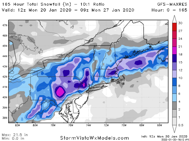
amugs wrote:GFS again here 12Z has a pretty well placed ULL about 50-75 miles more S would be optimum
Hoping for that S shift as NWS right now is saying a slop storm in my area which I would hate to see.

docstox12- Wx Statistician Guru

- Posts : 8504
Reputation : 222
Join date : 2013-01-07
Age : 73
Location : Monroe NY
Re: Long Range Thread 19.0
![]() by heehaw453 Mon Jan 20, 2020 11:30 am
by heehaw453 Mon Jan 20, 2020 11:30 am
docstox12 wrote:amugs wrote:GFS again here 12Z has a pretty well placed ULL about 50-75 miles more S would be optimum
Hoping for that S shift as NWS right now is saying a slop storm in my area which I would hate to see.
Unless that ULL is much further to the north, HV is in a good spot for this IMO. I don't believe this is going to be overly complex. If you are north of the ULL, then you will do well. IMO 2 more days are needed before getting too excited.
heehaw453- Advanced Forecaster

- Posts : 3906
Reputation : 86
Join date : 2014-01-20
Location : Bedminster Township, PA Elevation 600' ASL
Re: Long Range Thread 19.0
![]() by Frank_Wx Mon Jan 20, 2020 11:37 am
by Frank_Wx Mon Jan 20, 2020 11:37 am
_________________
_______________________________________________________________________________________________________
CLICK HERE to view NJ Strong Snowstorm Classifications

Frank_Wx- Godzilla Seeker

- Posts : 21305
Reputation : 328
Join date : 2013-01-05
Age : 31
Location : Jersey City, NJ -

Re: Long Range Thread 19.0
![]() by CPcantmeasuresnow Mon Jan 20, 2020 11:38 am
by CPcantmeasuresnow Mon Jan 20, 2020 11:38 am
Good for the HV and NWNJ not so good for most others on the forum. This far out pretty meaningless for all just posting for fun. I would take nothing from this at this early stage, other than the potential next weekend for someone to have a nice long duration storm rain, snow, mix, or both.


CPcantmeasuresnow- Wx Statistician Guru
- Posts : 7274
Reputation : 230
Join date : 2013-01-07
Age : 103
Location : Eastern Orange County, NY
Re: Long Range Thread 19.0
![]() by heehaw453 Mon Jan 20, 2020 11:51 am
by heehaw453 Mon Jan 20, 2020 11:51 am
What CP says is accurate though, in that we all may get skunked in the end, just less likely further north you go.

heehaw453- Advanced Forecaster
- Posts : 3906
Reputation : 86
Join date : 2014-01-20
Location : Bedminster Township, PA Elevation 600' ASL
Re: Long Range Thread 19.0
![]() by heehaw453 Mon Jan 20, 2020 2:06 pm
by heehaw453 Mon Jan 20, 2020 2:06 pm

Then ridge breaks down and ULL lift sharply NE. Mid levels then get flooded with warm air. The upshot this becomes a non event except for maybe elevations over 1200' feet NEPA northward.
The ULL actually is at a very good latitude for most of ride. It just the cut at the very end that does us in. Regardless though it's close enough to be of interest ATTM.

heehaw453- Advanced Forecaster
- Posts : 3906
Reputation : 86
Join date : 2014-01-20
Location : Bedminster Township, PA Elevation 600' ASL
Re: Long Range Thread 19.0
![]() by docstox12 Mon Jan 20, 2020 3:54 pm
by docstox12 Mon Jan 20, 2020 3:54 pm
docstox12- Wx Statistician Guru
- Posts : 8504
Reputation : 222
Join date : 2013-01-07
Age : 73
Location : Monroe NY
Re: Long Range Thread 19.0
![]() by frank 638 Mon Jan 20, 2020 3:59 pm
by frank 638 Mon Jan 20, 2020 3:59 pm

frank 638- Senior Enthusiast

- Posts : 2825
Reputation : 37
Join date : 2016-01-01
Age : 40
Location : bronx ny
Re: Long Range Thread 19.0
![]() by dkodgis Mon Jan 20, 2020 5:32 pm
by dkodgis Mon Jan 20, 2020 5:32 pm

dkodgis- Senior Enthusiast
- Posts : 2503
Reputation : 98
Join date : 2013-12-29
Re: Long Range Thread 19.0
![]() by jmanley32 Mon Jan 20, 2020 6:22 pm
by jmanley32 Mon Jan 20, 2020 6:22 pm

jmanley32- Senior Enthusiast
- Posts : 20516
Reputation : 108
Join date : 2013-12-12
Age : 42
Location : Yonkers, NY
Re: Long Range Thread 19.0
![]() by heehaw453 Mon Jan 20, 2020 6:30 pm
by heehaw453 Mon Jan 20, 2020 6:30 pm
Margin of error with ULL placement and trajectory at this range is probably few hundred miles or so. However, any more trending showing a failure of the trough to dig more and having sharp NE movement, then i'd be very skeptical of this event.

heehaw453- Advanced Forecaster
- Posts : 3906
Reputation : 86
Join date : 2014-01-20
Location : Bedminster Township, PA Elevation 600' ASL
Re: Long Range Thread 19.0
![]() by heehaw453 Tue Jan 21, 2020 6:39 am
by heehaw453 Tue Jan 21, 2020 6:39 am
Tomorrow after 12Z should really narrow the goal posts for the ULL.


12 hour later. A complete stall of the ULL

heehaw453- Advanced Forecaster
- Posts : 3906
Reputation : 86
Join date : 2014-01-20
Location : Bedminster Township, PA Elevation 600' ASL
Re: Long Range Thread 19.0
![]() by docstox12 Tue Jan 21, 2020 6:44 am
by docstox12 Tue Jan 21, 2020 6:44 am
docstox12- Wx Statistician Guru
- Posts : 8504
Reputation : 222
Join date : 2013-01-07
Age : 73
Location : Monroe NY
Re: Long Range Thread 19.0
![]() by heehaw453 Tue Jan 21, 2020 6:49 am
by heehaw453 Tue Jan 21, 2020 6:49 am
docstox12 wrote:Heehaw453, NWS must be seeing this as my forecast keeps getting snowier and less rainy.Very interesting analysis of the ULL.Seems to be trending a bit better the last 24 hours.It will be fun to watch the runs up to Friday morning.
Yes Doc your area is workable. You guys up there are savvy and know the bust potential. But I'm rooting for you!
heehaw453- Advanced Forecaster
- Posts : 3906
Reputation : 86
Join date : 2014-01-20
Location : Bedminster Township, PA Elevation 600' ASL
Re: Long Range Thread 19.0
![]() by Frank_Wx Tue Jan 21, 2020 6:49 am
by Frank_Wx Tue Jan 21, 2020 6:49 am
_________________
_______________________________________________________________________________________________________
CLICK HERE to view NJ Strong Snowstorm Classifications
Frank_Wx- Godzilla Seeker
- Posts : 21305
Reputation : 328
Join date : 2013-01-05
Age : 31
Location : Jersey City, NJ -
Re: Long Range Thread 19.0
![]() by Frank_Wx Tue Jan 21, 2020 7:58 pm
by Frank_Wx Tue Jan 21, 2020 7:58 pm
The bad news: it will struggle to go full latitude because the EPO region looks to remain positive. Further, the AO/NAO look to stay positive. To have these 3 indices positive with just 1 signal on our side is not ideal. This sounds like a very above normal pattern but the ridging over central Canada will continue and we likely stay normal to below normal. There will be snow chances but I am not particularly excited about much right now.
_________________
_______________________________________________________________________________________________________
CLICK HERE to view NJ Strong Snowstorm Classifications
Frank_Wx- Godzilla Seeker
- Posts : 21305
Reputation : 328
Join date : 2013-01-05
Age : 31
Location : Jersey City, NJ -
Re: Long Range Thread 19.0
![]() by weatherwatchermom Tue Jan 21, 2020 8:03 pm
by weatherwatchermom Tue Jan 21, 2020 8:03 pm
Frank_Wx wrote:The good news: the tropical Pacific will help the PNA stay neutral or slightly positive as we head into February.
The bad news: it will struggle to go full latitude because the EPO region looks to remain positive. Further, the AO/NAO look to stay positive. To have these 3 indices positive with just 1 signal on our side is not ideal. This sounds like a very above normal pattern but the ridging over central Canada will continue and we likely stay normal to below normal. There will be snow chances but I am not particularly excited about much right now.
thanks Frank for the update......we had such high hopes for this winter...I have adjusted my hopes to at least getting more than the 11 inches than we got last year down in my neck of the woods...I am usually a glass half full type of gal..but am feeling down about this weather.not ready to throw in any towel..but just a little sad...we had swarms of birds around the last week..are they coming back already? cold and dry wet and warm...

weatherwatchermom- Senior Enthusiast
- Posts : 3744
Reputation : 77
Join date : 2014-11-25
Age : 60
Location : Hazlet Township, NJ
Re: Long Range Thread 19.0
![]() by heehaw453 Wed Jan 22, 2020 6:37 am
by heehaw453 Wed Jan 22, 2020 6:37 am
heehaw453- Advanced Forecaster
- Posts : 3906
Reputation : 86
Join date : 2014-01-20
Location : Bedminster Township, PA Elevation 600' ASL
Re: Long Range Thread 19.0
![]() by Frank_Wx Wed Jan 22, 2020 8:32 am
by Frank_Wx Wed Jan 22, 2020 8:32 am
weatherwatchermom wrote:Frank_Wx wrote:The good news: the tropical Pacific will help the PNA stay neutral or slightly positive as we head into February.
The bad news: it will struggle to go full latitude because the EPO region looks to remain positive. Further, the AO/NAO look to stay positive. To have these 3 indices positive with just 1 signal on our side is not ideal. This sounds like a very above normal pattern but the ridging over central Canada will continue and we likely stay normal to below normal. There will be snow chances but I am not particularly excited about much right now.
thanks Frank for the update......we had such high hopes for this winter...I have adjusted my hopes to at least getting more than the 11 inches than we got last year down in my neck of the woods...I am usually a glass half full type of gal..but am feeling down about this weather.not ready to throw in any towel..but just a little sad...we had swarms of birds around the last week..are they coming back already? cold and dry wet and warm...
I give a lot of credit to Isotherm, aka Tom, who was one of the few forecasting a below normal snowfall this year for our area. I believe he is one of the best long range forecasters in our time. Many believed Modoki El Nino. low solar, east based QBO, etc. etc. would deliver an active snowy winter. It is not working out.
This is why I no longer issue winter outlooks. I do not have enough knowledge of the science to put out something like that with high confidence. In my opinion, many other people, some professional, should give up issuing them too.
heehaw453 wrote:Another cutter seems possible towards the end of January. I believe for most in terms of January snow totals what you have received to date is what you will wind up with. Maybe February renders better fortunes.
You have been a fantastic contributor by the way. Thank you.
_________________
_______________________________________________________________________________________________________
CLICK HERE to view NJ Strong Snowstorm Classifications
Frank_Wx- Godzilla Seeker
- Posts : 21305
Reputation : 328
Join date : 2013-01-05
Age : 31
Location : Jersey City, NJ -
Re: Long Range Thread 19.0
![]() by docstox12 Wed Jan 22, 2020 8:58 am
by docstox12 Wed Jan 22, 2020 8:58 am
docstox12- Wx Statistician Guru
- Posts : 8504
Reputation : 222
Join date : 2013-01-07
Age : 73
Location : Monroe NY
Re: Long Range Thread 19.0
![]() by heehaw453 Wed Jan 22, 2020 9:30 am
by heehaw453 Wed Jan 22, 2020 9:30 am
Frank_Wx wrote:weatherwatchermom wrote:Frank_Wx wrote:The good news: the tropical Pacific will help the PNA stay neutral or slightly positive as we head into February.
The bad news: it will struggle to go full latitude because the EPO region looks to remain positive. Further, the AO/NAO look to stay positive. To have these 3 indices positive with just 1 signal on our side is not ideal. This sounds like a very above normal pattern but the ridging over central Canada will continue and we likely stay normal to below normal. There will be snow chances but I am not particularly excited about much right now.
thanks Frank for the update......we had such high hopes for this winter...I have adjusted my hopes to at least getting more than the 11 inches than we got last year down in my neck of the woods...I am usually a glass half full type of gal..but am feeling down about this weather.not ready to throw in any towel..but just a little sad...we had swarms of birds around the last week..are they coming back already? cold and dry wet and warm...
I give a lot of credit to Isotherm, aka Tom, who was one of the few forecasting a below normal snowfall this year for our area. I believe he is one of the best long range forecasters in our time. Many believed Modoki El Nino. low solar, east based QBO, etc. etc. would deliver an active snowy winter. It is not working out.
This is why I no longer issue winter outlooks. I do not have enough knowledge of the science to put out something like that with high confidence. In my opinion, many other people, some professional, should give up issuing them too.heehaw453 wrote:Another cutter seems possible towards the end of January. I believe for most in terms of January snow totals what you have received to date is what you will wind up with. Maybe February renders better fortunes.
You have been a fantastic contributor by the way. Thank you.
Thanks Frank. I want to echo what you said about Isotherm. He took quite a bit of criticism last year due to his snowfall projections for the big cities. His long range forecast this year has been exceptionally accurate. He has stood steadfast to his forecast even for New England where in December one could have easily second guessed oneself and started to waffle. Places like Worcester had over 27" in December. Pattern went hostile henceforth from mid December for the majority of the time. Minimal high latitude blocking and a pacific fire hose, I believe pretty much on par with his projections.
I will say though that my latest readings from him it doesn't sound like he's too keen on anything before latter part of February. And even that is not confident. Moral of the story is don't expect much.
heehaw453- Advanced Forecaster
- Posts : 3906
Reputation : 86
Join date : 2014-01-20
Location : Bedminster Township, PA Elevation 600' ASL
Re: Long Range Thread 19.0
![]() by amugs Wed Jan 22, 2020 11:30 am
by amugs Wed Jan 22, 2020 11:30 am
Tom (Isotherm) is a phenomenal forecaster - he got scorned last year by his call and vowed to learn and not let that happen again and boy is he good.
The analogs were there with the weak nino, NE Pac Blob of warmer waters, a descending E QBO, blocking over the NAO region persisting with teh SST waters up there, low solar etc. BUT the IO Dipole, GWO along with the GLAAM I believe did us in. Watch we have a tremendous reversal in late February to delay spring,
_________________
Mugs
AKA:King: Snow Weenie
Self Proclaimed
WINTER 2014-15 : 55.12" +.02 for 6 coatings (avg. 35")
WINTER 2015-16 Total - 29.8" (Avg 35")
WINTER 2016-17 : 39.5" so far

amugs- Advanced Forecaster - Mod
- Posts : 15093
Reputation : 213
Join date : 2013-01-07
Age : 54
Location : Hillsdale,NJ
Re: Long Range Thread 19.0
![]() by docstox12 Wed Jan 22, 2020 11:37 am
by docstox12 Wed Jan 22, 2020 11:37 am
docstox12- Wx Statistician Guru
- Posts : 8504
Reputation : 222
Join date : 2013-01-07
Age : 73
Location : Monroe NY
Re: Long Range Thread 19.0
![]() by phil155 Wed Jan 22, 2020 11:46 am
by phil155 Wed Jan 22, 2020 11:46 am
phil155- Pro Enthusiast

- Posts : 475
Reputation : 4
Join date : 2019-12-16
Re: Long Range Thread 19.0
![]() by Frank_Wx Wed Jan 22, 2020 1:16 pm
by Frank_Wx Wed Jan 22, 2020 1:16 pm
phil155 wrote:Would be nice to get 1 system to truly thread the needle this year and give the region a good solid snowfall. Not expecting anything earth shattering this year as the pattern is not good for us but 1 good one would be nice
Agree! Maybe February or March holds surprises.
_________________
_______________________________________________________________________________________________________
CLICK HERE to view NJ Strong Snowstorm Classifications
Frank_Wx- Godzilla Seeker
- Posts : 21305
Reputation : 328
Join date : 2013-01-05
Age : 31
Location : Jersey City, NJ -
Page 17 of 28 • 1 ... 10 ... 16, 17, 18 ... 22 ... 28 ![]()
|
|
|