Long Range Thread 19.0
+38
essexcountypete
SoulSingMG
Scullybutcher
phil155
bobjohnsonforthehall
Zhukov1945
dsix85
Radz
lja
Grselig
devsman
DAYBLAZER
Irish
Dunnzoo
jimv45
sabamfa
SENJsnowman
frank 638
heehaw453
skinsfan1177
sroc4
hyde345
CPcantmeasuresnow
Math23x7
nutleyblizzard
rb924119
weatherwatchermom
aiannone
jmanley32
billg315
dkodgis
Snow88
algae888
docstox12
HectorO
mwilli
amugs
Frank_Wx
42 posters
Page 18 of 28
Page 18 of 28 •  1 ... 10 ... 17, 18, 19 ... 23 ... 28
 Re: Long Range Thread 19.0
Would be nice to get 1 system to truly thread the needle this year and give the region a good solid snowfall. Not expecting anything earth shattering this year as the pattern is not good for us but 1 good one would be nice
phil155- Pro Enthusiast

- Posts : 475
Join date : 2019-12-16
 Re: Long Range Thread 19.0
phil155 wrote:Would be nice to get 1 system to truly thread the needle this year and give the region a good solid snowfall. Not expecting anything earth shattering this year as the pattern is not good for us but 1 good one would be nice
Agree! Maybe February or March holds surprises.
 Re: Long Range Thread 19.0
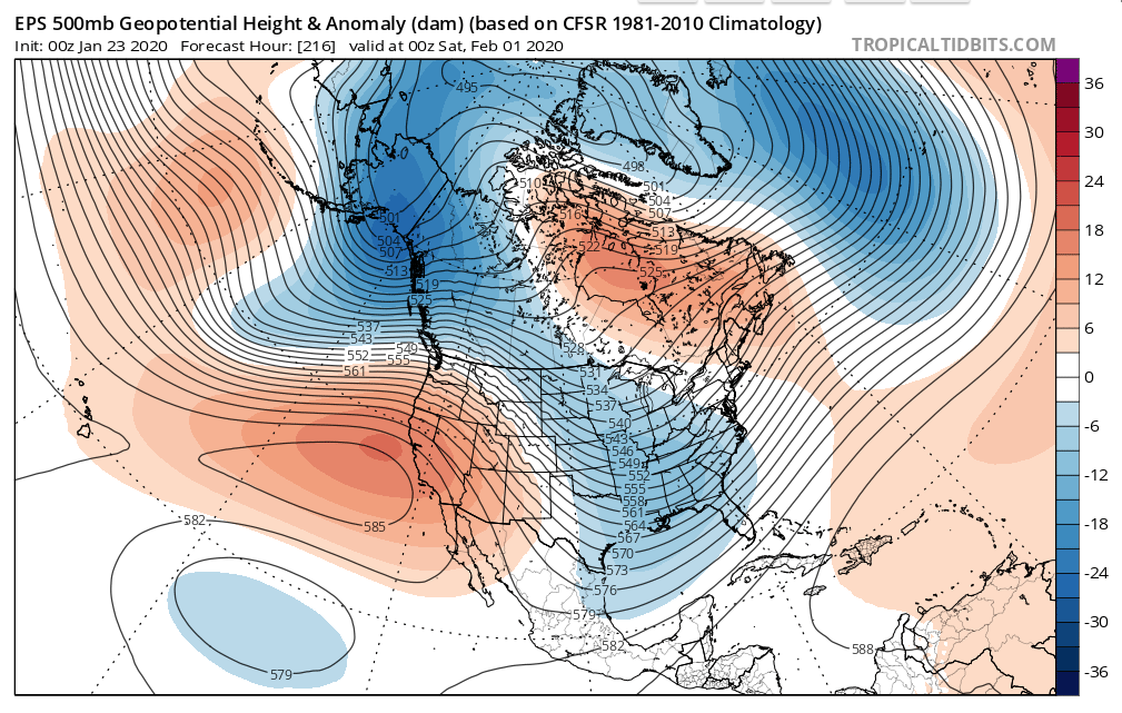
This is a somewhat workable look for day 9 as shown on the Euro Ensembles. The Pacific actually looks decent and the Atlantic ridge is far enough away that this most likely dare I say won't be a cutter. No Atlantic blocking or -EPO (Alaska has trough), but in prime climatology this could work. You can't have every teleconnection look great and even when you do that doesn't guarantee a snowstorm IYBY believe you me. Let's see how this looks in a few days.

heehaw453- Advanced Forecaster

- Posts : 3906
Reputation : 86
Join date : 2014-01-20
Location : Bedminster Township, PA Elevation 600' ASL
 Re: Long Range Thread 19.0
Stupid question but what does IYBY mean?...i see it in here a lot.....sorry
mwilli- Posts : 132
Reputation : 3
Join date : 2019-02-11
 Re: Long Range Thread 19.0
mwilli wrote:Stupid question but what does IYBY mean?...i see it in here a lot.....sorry
In Your Back Yard
IMBY = In My Back Yard
_________________
"In weather and in life, there's no winning and losing; there's only winning and learning."
WINTER 2012/2013 TOTALS 43.65"WINTER 2017/2018 TOTALS 62.85" WINTER 2022/2023 TOTALS 4.9"
WINTER 2013/2014 TOTALS 64.85"WINTER 2018/2019 TOTALS 14.25" WINTER 2023/2024 TOTALS 13.1"
WINTER 2014/2015 TOTALS 71.20"WINTER 2019/2020 TOTALS 6.35"
WINTER 2015/2016 TOTALS 35.00"WINTER 2020/2021 TOTALS 37.75"
WINTER 2016/2017 TOTALS 42.25"WINTER 2021/2022 TOTALS 31.65"

sroc4- Admin

- Posts : 8331
Reputation : 301
Join date : 2013-01-07
Location : Wading River, LI
 Re: Long Range Thread 19.0
Thank you.......now let's get back to weather and hopefully 2/1 snowstorm
mwilli- Posts : 132
Reputation : 3
Join date : 2019-02-11
 Re: Long Range Thread 19.0
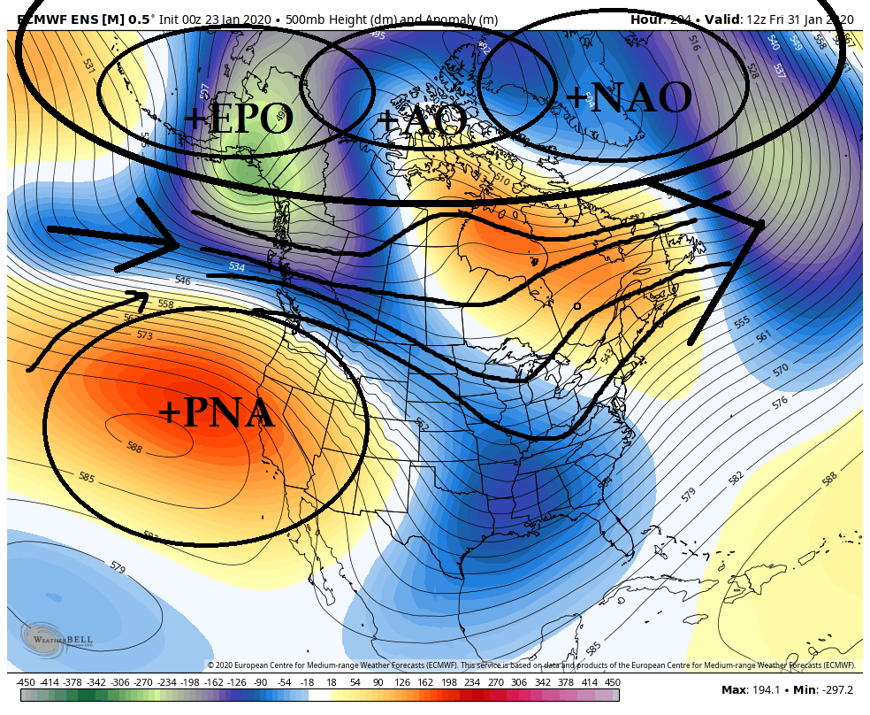
So here is your 500mb ensemble mean look headed into the Feb 1st (+/-24-36hrs). What do we have?
1) +EPO
2) +AO
3) +NAO
4) +PNA
Now that's a lot of positives, but unfort 3 of 4 of the above positive states are not typically favorable for cold air outbreaks and snow in the NE. The EPO/AO/NAO all in the positive state typically locks the coldest of air way up in N Canada and the Arctic, which means the air in most of Canada including out source region is modified Pac air.
The +PNA is really the only teleconnection that is favorable for snow into the NE. Frank pointed this very thing out the other day, and Heehaws thoughts from earlier also echo my thoughts below. As you can see the ridge out west forces the jet stream to become a little more meridonial in the western half of the CONUS.
So here is the thing. On paper this pattern is absolutely awful if you want cold and or snow in the north east. Probabilities say if you were to bet money here you either stay away from this bet, or bet wet not white, esp the closer to the coast you live. But here is the thing. We have all been a part of this board long enough to have lived long enough to know that even horrible patterns produces snow, as well as the favorable pattern not produce.
Entering from the left now is the cliche its a "thread the needle set up".
Look we cant avoid it. Everything has to be perfect. As you can see from this image below the coldest of air is locked up way far north, but even though modified Pac air is flooding most of Canada and they are experiencing above normal temps for the time frame in question, if the storm track is right it is "cold enough" to still support snow in Mid Jan IYBY(for mwillie), again IF the storm track is right.
The strength and the position if the +PNA ridge axis is absolutely vital. With 200+ hours though until this plays out nothing more than hey in a shitty pattern here is a potential way to produce. Keep your expectations low, and dont over over think what could or couldnt happen until we are inside 3-5 days. Right now last nights euro op surface run is nothing but noise. Over the next few days Ill be looking for trends to the west coast ridge in strength and position. Nothing more, nothing less. Even looking at the 500mb vorticity maps this far out is futile. Again there is always a chance.

Last edited by sroc4 on Thu Jan 23, 2020 11:52 am; edited 1 time in total
_________________
"In weather and in life, there's no winning and losing; there's only winning and learning."
WINTER 2012/2013 TOTALS 43.65"WINTER 2017/2018 TOTALS 62.85" WINTER 2022/2023 TOTALS 4.9"
WINTER 2013/2014 TOTALS 64.85"WINTER 2018/2019 TOTALS 14.25" WINTER 2023/2024 TOTALS 13.1"
WINTER 2014/2015 TOTALS 71.20"WINTER 2019/2020 TOTALS 6.35"
WINTER 2015/2016 TOTALS 35.00"WINTER 2020/2021 TOTALS 37.75"
WINTER 2016/2017 TOTALS 42.25"WINTER 2021/2022 TOTALS 31.65"

sroc4- Admin

- Posts : 8331
Reputation : 301
Join date : 2013-01-07
Location : Wading River, LI
 Re: Long Range Thread 19.0
Scott - echoes my thoughts from the other day!
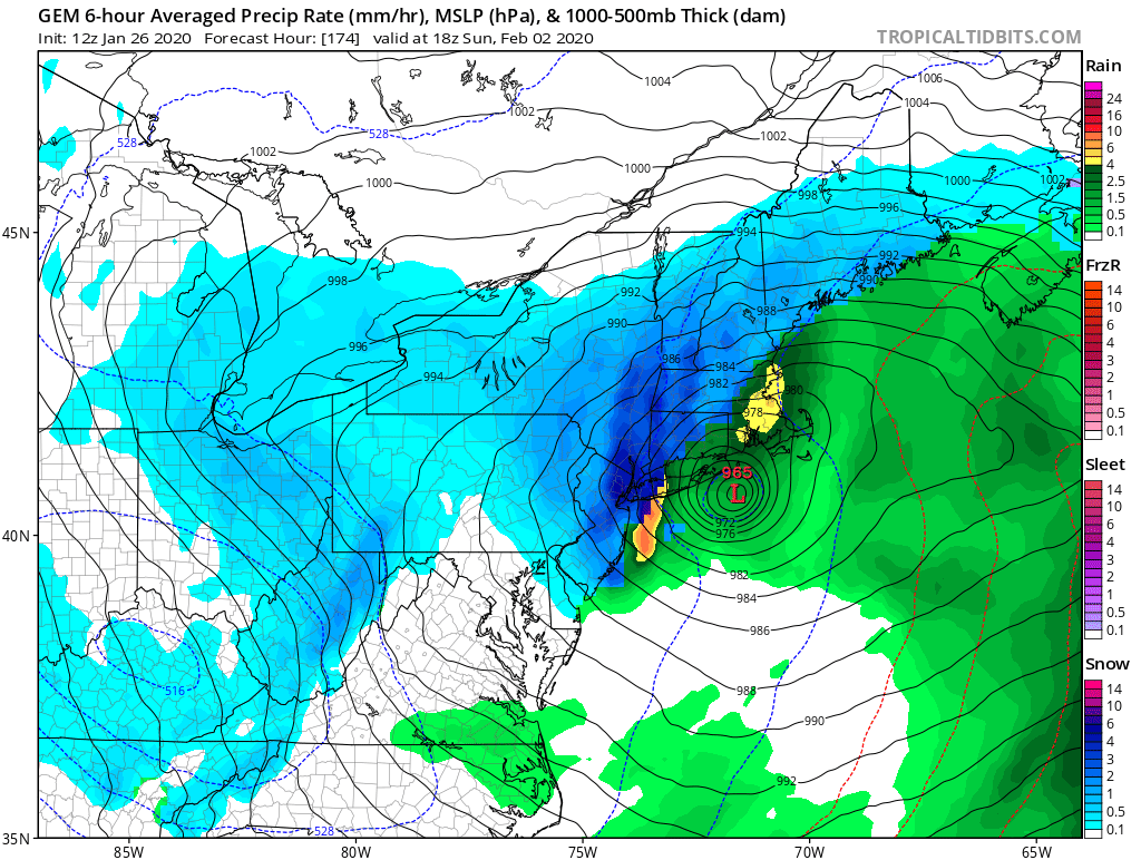
Today's models show a really big storm on the coast February 2nd. If that keeps showing up through this weekend consider me excited!
Today's models show a really big storm on the coast February 2nd. If that keeps showing up through this weekend consider me excited!
_________________
_______________________________________________________________________________________________________
CLICK HERE to view NJ Strong Snowstorm Classifications
 Re: Long Range Thread 19.0
Frank_Wx wrote:Scott - echoes my thoughts from the other day!
Today's models show a really big storm on the coast February 2nd. If that keeps showing up through this weekend consider me excited!
Totally Frank...and I went back and added a little credit because you 100% did. I also credited Heehaw as well. Eventually if mother nature attempts to thread the needle enough times she will eventually thread the needle. Lets hope Old mother nature is wearing her reading glasses for this upcoming time frame.
_________________
"In weather and in life, there's no winning and losing; there's only winning and learning."
WINTER 2012/2013 TOTALS 43.65"WINTER 2017/2018 TOTALS 62.85" WINTER 2022/2023 TOTALS 4.9"
WINTER 2013/2014 TOTALS 64.85"WINTER 2018/2019 TOTALS 14.25" WINTER 2023/2024 TOTALS 13.1"
WINTER 2014/2015 TOTALS 71.20"WINTER 2019/2020 TOTALS 6.35"
WINTER 2015/2016 TOTALS 35.00"WINTER 2020/2021 TOTALS 37.75"
WINTER 2016/2017 TOTALS 42.25"WINTER 2021/2022 TOTALS 31.65"

sroc4- Admin

- Posts : 8331
Reputation : 301
Join date : 2013-01-07
Location : Wading River, LI
 Re: Long Range Thread 19.0
I shouldn't be making a stink about a day 10 surface depiction, but a 954mb low at the BM would be a Godzilla/Roidzilla for all.Frank_Wx wrote:Scott - echoes my thoughts from the other day!
Today's models show a really big storm on the coast February 2nd. If that keeps showing up through this weekend consider me excited!

nutleyblizzard- Senior Enthusiast

- Posts : 1952
Reputation : 41
Join date : 2014-01-30
Age : 58
Location : Nutley, new jersey
 Re: Long Range Thread 19.0
Just watched lee Goldberg 7 day forecast he did say there is a pattern change starting next week to a colder and stormy pattern and he did say we have to watch for next Sunday.i don’t know what to believe anymore
frank 638- Senior Enthusiast

- Posts : 2825
Reputation : 37
Join date : 2016-01-01
Age : 40
Location : bronx ny
 Re: Long Range Thread 19.0
frank 638 wrote:Just watched lee Goldberg 7 day forecast he did say there is a pattern change starting next week to a colder and stormy pattern and he did say we have to watch for next Sunday.i don’t know what to believe anymore
Don't believe anything at this early stage.
FYI- Todays 12Z GFS had 32 inches of snow for next weekends storm in extreme NWNJ, 6 hours later the 18Z GFS shows 2 inches over NWNJ.
Lots and lots and lots of time for this one,anythings on the table.

CPcantmeasuresnow- Wx Statistician Guru

- Posts : 7274
Reputation : 230
Join date : 2013-01-07
Age : 103
Location : Eastern Orange County, NY
 Re: Long Range Thread 19.0
That 12z GFS run had everything I could want a ton of snow and 60+ mph winds, heck they could be over hurricane force at 954mb jeeze. But yeah I highly doubt it, but who knows?!

jmanley32- Senior Enthusiast

- Posts : 20516
Reputation : 108
Join date : 2013-12-12
Age : 42
Location : Yonkers, NY
 Re: Long Range Thread 19.0
frank 638 wrote:Just watched lee Goldberg 7 day forecast he did say there is a pattern change starting next week to a colder and stormy pattern and he did say we have to watch for next Sunday.i don’t know what to believe anymore
For those of God anothwr PMDF = pro.met death forecast , they do this and they kill a storm. When they call for 2-4 we get 4-6.
The pattern is juicy, the sub tropical jet is flowing, there will be chances, we need things, plural to align. We have snowed in crappy patterns before and will again its winter not Nov or early Dec. 2016 Blizzard ring a bell?? Not to that level boy this would incredible but just saying it is possible.
_________________
Mugs
AKA:King: Snow Weenie
Self Proclaimed
WINTER 2014-15 : 55.12" +.02 for 6 coatings (avg. 35")
WINTER 2015-16 Total - 29.8" (Avg 35")
WINTER 2016-17 : 39.5" so far

amugs- Advanced Forecaster - Mod

- Posts : 15093
Reputation : 213
Join date : 2013-01-07
Age : 54
Location : Hillsdale,NJ
 Re: Long Range Thread 19.0
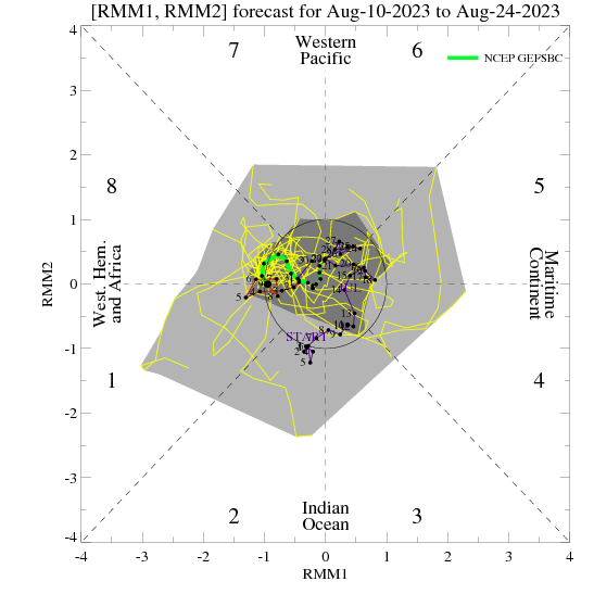
ENS models are showing a possible pattern change next weekend as the MJO heads into the null phase and we have a warming from a + EAMT (East Asian Mountain Torque) Time will tell
Dr Cohen shows this in tweet here
https://twitter.com/judah47/status/1220792465529212929?s=20


Dr Cohen shows this in tweet here
https://twitter.com/judah47/status/1220792465529212929?s=20


_________________
Mugs
AKA:King: Snow Weenie
Self Proclaimed
WINTER 2014-15 : 55.12" +.02 for 6 coatings (avg. 35")
WINTER 2015-16 Total - 29.8" (Avg 35")
WINTER 2016-17 : 39.5" so far

amugs- Advanced Forecaster - Mod

- Posts : 15093
Reputation : 213
Join date : 2013-01-07
Age : 54
Location : Hillsdale,NJ
 Re: Long Range Thread 19.0
This elongation of the PV will hopefully affects our pattern toward the mid Feb period & forward.


_________________
Mugs
AKA:King: Snow Weenie
Self Proclaimed
WINTER 2014-15 : 55.12" +.02 for 6 coatings (avg. 35")
WINTER 2015-16 Total - 29.8" (Avg 35")
WINTER 2016-17 : 39.5" so far

amugs- Advanced Forecaster - Mod

- Posts : 15093
Reputation : 213
Join date : 2013-01-07
Age : 54
Location : Hillsdale,NJ
 Re: Long Range Thread 19.0
Sorry to complain but winter needs to end in Feb. Spring needs start in march. If we keep on this path June will be our new winter in 10 years lol

jmanley32- Senior Enthusiast

- Posts : 20516
Reputation : 108
Join date : 2013-12-12
Age : 42
Location : Yonkers, NY
 Re: Long Range Thread 19.0
jmanley32 wrote:Sorry to complain but winter needs to end in Feb. Spring needs start in march. If we keep on this path June will be our new winter in 10 years lol
I agree. It seems like the cold is holding on later and later and it stays warm longer into fall.
Scullybutcher- Pro Enthusiast

- Posts : 543
Reputation : 16
Join date : 2013-02-06
Location : North Smithtown, western Suffolk county, long island
 Re: Long Range Thread 19.0
Regarding next Saturday's threat.
So you can see a favorable storm track on 06Z GFS. But what don't we have? Deep cold and HP to the north to keep the flow more northerly than south westerly. That would cause enough warming to kill the coast chances for white. Even interior would struggle with this setup IMO.
Note the wind barbs coming from south west. Ooy. Have to see if there is something else that can help with this in next two days. Some models are hinting at more northerly stream and not much southerly stream. That would keep things colder, but less QPF of course. The other possibility is the storm moves off the coast faster and bombs which switches the flow more quickly. T
Again folks it's these windows that i keep referring to. In the bleakest of setups I've seen snow, so we'll see.

heehaw453- Advanced Forecaster

- Posts : 3906
Reputation : 86
Join date : 2014-01-20
Location : Bedminster Township, PA Elevation 600' ASL
 Re: Long Range Thread 19.0
jmanley32 wrote:Sorry to complain but winter needs to end in Feb. Spring needs start in march. If we keep on this path June will be our new winter in 10 years lol
March has never been a Spring month in the NE and climate wise never should be or we've really messed things up worse than even I thought. The end of April at best is when you can start looking for consistently nice weather around here (HV), which to me means mid to high 60's consistently during the day and 40's at night) and most of the time not until May.
Even in NYC the average high temp doesn't hit 70 until May 11. To ask for Spring in March is unnatural, and yes I know you ask for it out of frustration with the winter that isn't.

CPcantmeasuresnow- Wx Statistician Guru

- Posts : 7274
Reputation : 230
Join date : 2013-01-07
Age : 103
Location : Eastern Orange County, NY
 Re: Long Range Thread 19.0
Today's models are in agreement on a pattern change taking place next week. As is the case with our last pattern change in early January, will this one be permanent or temporary like the last one? That depends on what occurs in the Stratosphere.
GFS depicts a Wave 1 warming event that displaces the Strat PV into Siberia by February 5th (but the major warming begins around February 1st). This is 10 hPa, the middle region of the Stratosphere.

The EURO in the same time frame shows a much different looks. It depicts at Strat PV SPLT - with the PV being squeezed from Wave 2 warming and one lobe going into Canada and the other into Siberia. This scenario would benefit our area the most in terms of setting up a snowier pattern.
Over the next few days it will be interesting to see which model is right. Either way, whether it is a Wave 1 or Wave 2 warming event, this sudden stratospheric warming event should change our pattern. But permanently?

10 hPa winds are in a strong easterly state but are forecasted to get very close to reversing westerly. But, very close is not good enough because in my opinion it means there is a chance the Strat PV can re-gain its strength. We want to see a full reversal to westerly winds (the red line shown to go below 0 line).
Summary:
SSWE coming but Wave 1 or 2?
Temporary or permanent pattern change?
Big coastal storms are showing up more and more on the models...
GFS depicts a Wave 1 warming event that displaces the Strat PV into Siberia by February 5th (but the major warming begins around February 1st). This is 10 hPa, the middle region of the Stratosphere.

The EURO in the same time frame shows a much different looks. It depicts at Strat PV SPLT - with the PV being squeezed from Wave 2 warming and one lobe going into Canada and the other into Siberia. This scenario would benefit our area the most in terms of setting up a snowier pattern.
Over the next few days it will be interesting to see which model is right. Either way, whether it is a Wave 1 or Wave 2 warming event, this sudden stratospheric warming event should change our pattern. But permanently?

10 hPa winds are in a strong easterly state but are forecasted to get very close to reversing westerly. But, very close is not good enough because in my opinion it means there is a chance the Strat PV can re-gain its strength. We want to see a full reversal to westerly winds (the red line shown to go below 0 line).
Summary:
SSWE coming but Wave 1 or 2?
Temporary or permanent pattern change?
Big coastal storms are showing up more and more on the models...
_________________
_______________________________________________________________________________________________________
CLICK HERE to view NJ Strong Snowstorm Classifications
 Re: Long Range Thread 19.0
CPcantmeasuresnow wrote:jmanley32 wrote:Sorry to complain but winter needs to end in Feb. Spring needs start in march. If we keep on this path June will be our new winter in 10 years lol
March has never been a Spring month in the NE and climate wise never should be or we've really messed things up worse than even I thought. The end of April at best is when you can start looking for consistently nice weather around here (HV), which to me means mid to high 60's consistently during the day and 40's at night) and most of the time not until May.
Even in NYC the average high temp doesn't hit 70 until May 11. To ask for Spring in March is unnatural, and yes I know you ask for it out of frustration with the winter that isn't.
Just going to go ahead and agree with Jman, bring on spring. Even when things do get cold a couple days later we have a washout of rain anyways.

HectorO- Pro Enthusiast

- Posts : 959
Reputation : 27
Join date : 2013-01-11
 Re: Long Range Thread 19.0
Edited:
Getting more confidence in not having a cutter for the weekend...
FWIW GFS was really close to a big dog event @ 12Z. A little sloppy phase is all that prevented CCB from ripping here.
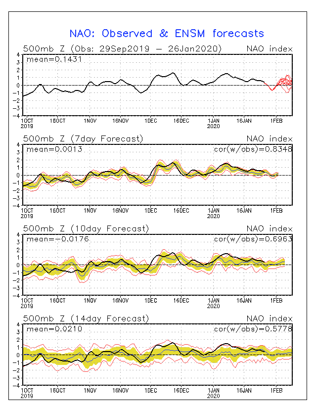
The window for the weekend has two key 500mb weather patterns that are decent. Once again, not a good chance ATTM. But a chance nonetheless.
NAO in a dip currently. Look how high it was in January and hence the snowfall output. Also notice the early December snowstorm how it dipped right before the event.
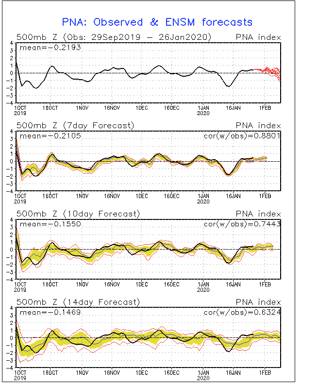
PNA in a rising phase. Look how bad it has been in January and hence the snowfall output.
Getting more confidence in not having a cutter for the weekend...
FWIW GFS was really close to a big dog event @ 12Z. A little sloppy phase is all that prevented CCB from ripping here.
The window for the weekend has two key 500mb weather patterns that are decent. Once again, not a good chance ATTM. But a chance nonetheless.
NAO in a dip currently. Look how high it was in January and hence the snowfall output. Also notice the early December snowstorm how it dipped right before the event.

PNA in a rising phase. Look how bad it has been in January and hence the snowfall output.

heehaw453- Advanced Forecaster

- Posts : 3906
Reputation : 86
Join date : 2014-01-20
Location : Bedminster Township, PA Elevation 600' ASL
 Re: Long Range Thread 19.0
As of now on the 10 day, most highs are mid 40s on average and lows in most cases barely hit freezing. Several storms on the horizon but with the looks of these temps, they won't be white for my area.

Irish- Pro Enthusiast

- Posts : 788
Reputation : 19
Join date : 2019-01-16
Age : 45
Location : Old Bridge, NJ
 Re: Long Range Thread 19.0
The 12z GGEM just went bonkers for next weekend. 

SoulSingMG- Senior Enthusiast

- Posts : 2853
Reputation : 74
Join date : 2013-12-11
Location : Long Island City, NY
 Re: Long Range Thread 19.0
Irish wrote:As of now on the 10 day, most highs are mid 40s on average and lows in most cases barely hit freezing. Several storms on the horizon but with the looks of these temps, they won't be white for my area.
Current guidance suggests next shot of more sustained cold air is after 2/5. Before that your expectations sound very reasonable IYBY for wet in lieu of white. We need a lot to go right for this weekend that's for sure.
heehaw453- Advanced Forecaster

- Posts : 3906
Reputation : 86
Join date : 2014-01-20
Location : Bedminster Township, PA Elevation 600' ASL

nutleyblizzard- Senior Enthusiast

- Posts : 1952
Reputation : 41
Join date : 2014-01-30
Age : 58
Location : Nutley, new jersey
Page 18 of 28 •  1 ... 10 ... 17, 18, 19 ... 23 ... 28
Page 18 of 28
Permissions in this forum:
You cannot reply to topics in this forum|
|
|

 Home
Home