Long Range Thread 19.0
+38
essexcountypete
SoulSingMG
Scullybutcher
phil155
bobjohnsonforthehall
Zhukov1945
dsix85
Radz
lja
Grselig
devsman
DAYBLAZER
Irish
Dunnzoo
jimv45
sabamfa
SENJsnowman
frank 638
heehaw453
skinsfan1177
sroc4
hyde345
CPcantmeasuresnow
Math23x7
nutleyblizzard
rb924119
weatherwatchermom
aiannone
jmanley32
billg315
dkodgis
Snow88
algae888
docstox12
HectorO
mwilli
amugs
Frank_Wx
42 posters
Page 28 of 28
Page 28 of 28 •  1 ... 15 ... 26, 27, 28
 Re: Long Range Thread 19.0
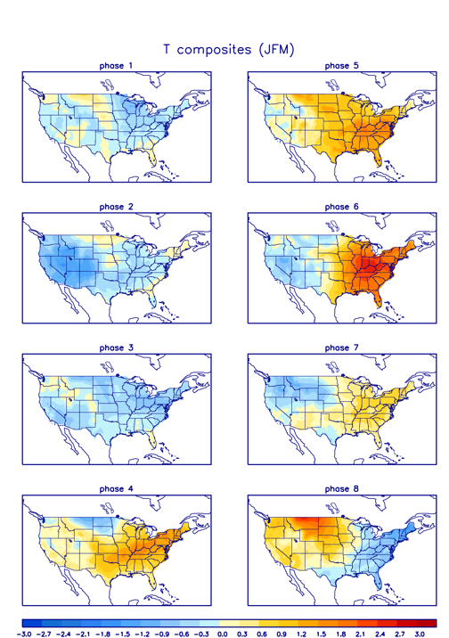
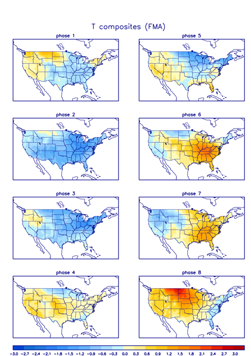
algae888 wrote:Scott I believe phase 4 mjo in March is a cold signalsroc4 wrote:That Western Ridge will be key. Let’s see if it can stay amplified. MJO signal is questionable.
Here are the temp composites for Jan/Feb/March, Feb/March/Apr, and March/Apr/May respectively. As you can see phase 4 is a transition phase with the composite being a mostly warmer phase until March April May. At least through these composites def not cold. We shall see.

sroc4- Admin

- Posts : 8354
Join date : 2013-01-07
 Re: Long Range Thread 19.0
So chance of some snow this Friday, which at this point I'll take what I can get even if this looks like one of those snows that melts as it falls. But that GFS run this morning for next Thursday (3/12) looks real nice. lol. I know, I know, 9 days off, but at least it was something to get excited about. And truthfully, that March 10-15 time-frame has produced some big snowstorms for this region in the past so it would fit with that tradition.
billg315- Advanced Forecaster - Mod

- Posts : 4483
Join date : 2015-01-24
 Re: Long Range Thread 19.0
How many times have we seen our crocuses and daffodils and forsythia covered with snow? We all know this can happen. I was thinking the other day that the stock market is for long-term investments but we seem to pay too much attention to the market all the time (Doc, I bet you are falling off your chair, laughing!); I am starting to feel that way about the weather. I am paying too much attention to it, trying to get wish snow into my life for the inner kid in me. Next Thursday's weather is like horses off on the race; as we get closer, our fortunes rise and fall. Which will it be?

dkodgis- Senior Enthusiast

- Posts : 2560
Reputation : 98
Join date : 2013-12-29
 Re: Long Range Thread 19.0
That offshore shortwave energy on 12Z GFS is very close to interacting with the northern stream in a decent spot for us. We are not getting an ideal phase here due to lack of blocking (+AO/+NAO), but I could definitely see this blowing up a bit closer to us before it tries to lift out. This is like tantalizing close.
I see path to good snow two ways (both rather low probability ATTM IMO):
1. Get the western ridge a hair sharper to force the northern stream down faster.
2. A bit more influence from the departing transient low to slow the atmosphere down.
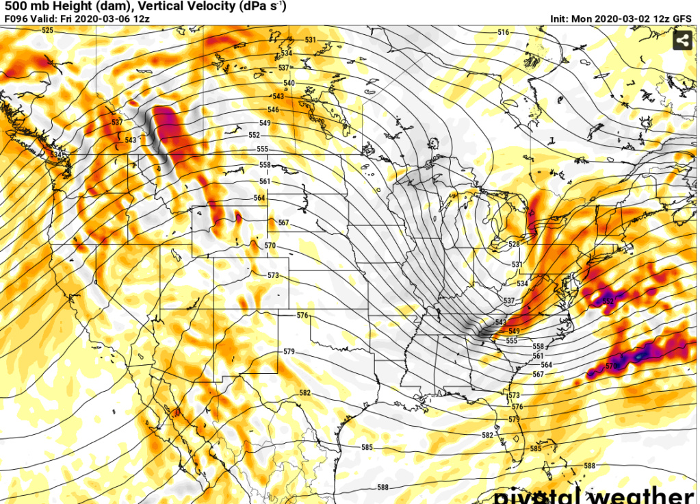
I see path to good snow two ways (both rather low probability ATTM IMO):
1. Get the western ridge a hair sharper to force the northern stream down faster.
2. A bit more influence from the departing transient low to slow the atmosphere down.

heehaw453- Advanced Forecaster

- Posts : 3906
Reputation : 86
Join date : 2014-01-20
Location : Bedminster Township, PA Elevation 600' ASL
 Re: Long Range Thread 19.0
Thinking some white rain is very possible for Friday evening. Hopefully the March flow acts in our favor, but I just don't see the departing low slowing things down that much or the ridge becoming sharp enough to make a difference. I anticipate mood flakes on Friday night, which is better than nothing I suppose.

bobjohnsonforthehall- Posts : 311
Reputation : 19
Join date : 2016-10-02
Location : Flemington NJ
 Re: Long Range Thread 19.0
Definitely. We'd be well below freezing above 2000 feet, but the surface temps well above 32 for white rain. For now I think you are spot on unless we see some changes at the 500mb. Won't take drastic changes, but changes nonetheless.bobjohnsonforthehall wrote:Thinking some white rain is very possible for Friday evening. Hopefully the March flow acts in our favor, but I just don't see the departing low slowing things down that much or the ridge becoming sharp enough to make a difference. I anticipate mood flakes on Friday night, which is better than nothing I suppose.
heehaw453- Advanced Forecaster

- Posts : 3906
Reputation : 86
Join date : 2014-01-20
Location : Bedminster Township, PA Elevation 600' ASL
 Re: Long Range Thread 19.0
Euro ensembles have quite a few with significant hits. Maybe 20-25% of them. That is more than I would have thought. Plus still four days out. Not holding my breath but certainly bears continued watching until the proverbial Lucy with the football action begins.

bobjohnsonforthehall- Posts : 311
Reputation : 19
Join date : 2016-10-02
Location : Flemington NJ
 Re: Long Range Thread 19.0
Most likely this will be minimal if any impact to us.
No cold antecedent air mass means this storm is going to have to crank to allow for dynamic cooling right down to the surface which will be most difficult to cool. We also are battling a +AO/+NAO (albeit somewhat relaxed) which means slowing the atmosphere isn't coming easy and no real cold press. But we keep seeing a decent amount (~50%) of EPS split out significant impacts (>= 4") because synoptically this isn't a bad setup. That transient low (slow atmosphere a tad) and that western ridge (PNA) may make it work, albeit not likely. IMO this would be damn near a slam dunk with even moderately negative NAO. But alas...
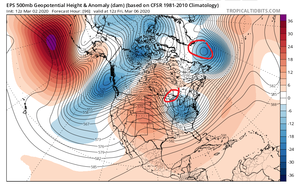
No cold antecedent air mass means this storm is going to have to crank to allow for dynamic cooling right down to the surface which will be most difficult to cool. We also are battling a +AO/+NAO (albeit somewhat relaxed) which means slowing the atmosphere isn't coming easy and no real cold press. But we keep seeing a decent amount (~50%) of EPS split out significant impacts (>= 4") because synoptically this isn't a bad setup. That transient low (slow atmosphere a tad) and that western ridge (PNA) may make it work, albeit not likely. IMO this would be damn near a slam dunk with even moderately negative NAO. But alas...

heehaw453- Advanced Forecaster

- Posts : 3906
Reputation : 86
Join date : 2014-01-20
Location : Bedminster Township, PA Elevation 600' ASL
 Re: Long Range Thread 19.0
A glimmer of hope perhaps. 
http://www.msn.com/en-us/weather/topstories/could-a-big-storm-end-snow-drought-in-the-northeast-this-winter/ar-BB10DZg6?li=BBnbfcL&ocid=SK2HDHP
http://www.msn.com/en-us/weather/topstories/could-a-big-storm-end-snow-drought-in-the-northeast-this-winter/ar-BB10DZg6?li=BBnbfcL&ocid=SK2HDHP
GreyBeard- Senior Enthusiast

- Posts : 725
Reputation : 34
Join date : 2014-02-12
Location : eastern nassau county
 Re: Long Range Thread 19.0
GreyBeard wrote:A glimmer of hope perhaps.
http://www.msn.com/en-us/weather/topstories/could-a-big-storm-end-snow-drought-in-the-northeast-this-winter/ar-BB10DZg6?li=BBnbfcL&ocid=SK2HDHP
I would say barely a glimmer. The way things have been this year, I can for sure see scenario #1, snow to the north and south, nada here. Of course, the meet-up is Saturday, and we had to cancel the last one due to a weather event, what are the odds?
_________________
Janet
Snowfall winter of 2023-2024 17.5"
Snowfall winter of 2022-2023 6.0"
Snowfall winter of 2021-2022 17.6" 1" sleet 2/25/22
Snowfall winter of 2020-2021 51.1"
Snowfall winter of 2019-2020 8.5"
Snowfall winter of 2018-2019 25.1"
Snowfall winter of 2017-2018 51.9"
Snowfall winter of 2016-2017 45.6"
Snowfall winter of 2015-2016 29.5"
Snowfall winter of 2014-2015 50.55"
Snowfall winter of 2013-2014 66.5"
Dunnzoo- Senior Enthusiast - Mod

- Posts : 4905
Reputation : 68
Join date : 2013-01-11
Age : 62
Location : Westwood, NJ
 Re: Long Range Thread 19.0
Hear ye, hear ye stick the fork in ye threat.
The spacing of the northern stream and southern stream shortwave energy isn't going to allow for any meaningful impact to our area. The atmospheric flow is just too fast to overcome compliments of our perpetual +NAM state.
A long shot it was and the same impact it becomes la garbage in the winter as such.
GEFS tries to show some mild -NAO towards March 18. Just think it'll be too little too late around here and ye old snow books are getting ready to close.
heehaw453- Advanced Forecaster

- Posts : 3906
Reputation : 86
Join date : 2014-01-20
Location : Bedminster Township, PA Elevation 600' ASL
 Re: Long Range Thread 19.0
heehaw453 wrote:Hear ye, hear ye stick the fork in ye threat.
The spacing of the northern stream and southern stream shortwave energy isn't going to allow for any meaningful impact to our area. The atmospheric flow is just too fast to overcome compliments of our perpetual +NAM state.
A long shot it was and the same impact it becomes la garbage in the winter as such.
GEFS tries to show some mild -NAO towards March 18. Just think it'll be too little too late around here and ye old snow books are getting ready to close.
Its over

skinsfan1177- Senior Enthusiast

- Posts : 4485
Reputation : 35
Join date : 2013-01-07
Age : 46
Location : Point Pleasant Boro
 Re: Long Range Thread 19.0
skinsfan1177 wrote:heehaw453 wrote:Hear ye, hear ye stick the fork in ye threat.
The spacing of the northern stream and southern stream shortwave energy isn't going to allow for any meaningful impact to our area. The atmospheric flow is just too fast to overcome compliments of our perpetual +NAM state.
A long shot it was and the same impact it becomes la garbage in the winter as such.
GEFS tries to show some mild -NAO towards March 18. Just think it'll be too little too late around here and ye old snow books are getting ready to close.
Its over
Yes. Hibernation is coming early this year.
heehaw453- Advanced Forecaster

- Posts : 3906
Reputation : 86
Join date : 2014-01-20
Location : Bedminster Township, PA Elevation 600' ASL
 Re: Long Range Thread 19.0
I've always been a bit contrarian, even if only to be proven wrong for it. As much as I want to say "it's over" because frankly I'm sick of this (lack of) winter and ready to move onto Spring . . . I am still watching March 12. There is definitely a system consistently showing up just off or on the Mid-Atlantic coast on that date. The exact location has bounced back and forth but just north and west of it, it is consistently showing cold and frankly lots of snow and frozen precip. If the positioning of such a system were just right, it could be that sneaky "one storm in a bad pattern" we've been looking for. Is it likely the way this winter has gone? No. But I won't write it off yet. Because without hope, what have we?

billg315- Advanced Forecaster - Mod

- Posts : 4483
Reputation : 185
Join date : 2015-01-24
Age : 50
Location : Flemington, NJ
 Re: Long Range Thread 19.0
billg315 wrote:I've always been a bit contrarian, even if only to be proven wrong for it. As much as I want to say "it's over" because frankly I'm sick of this (lack of) winter and ready to move onto Spring . . . I am still watching March 12. There is definitely a system consistently showing up just off or on the Mid-Atlantic coast on that date. The exact location has bounced back and forth but just north and west of it, it is consistently showing cold and frankly lots of snow and frozen precip. If the positioning of such a system were just right, it could be that sneaky "one storm in a bad pattern" we've been looking for. Is it likely the way this winter has gone? No. But I won't write it off yet. Because without hope, what have we?
I’m right there with you Bill. And even those who have written it off likely haven’t written it off.
_________________
"In weather and in life, there's no winning and losing; there's only winning and learning."
WINTER 2012/2013 TOTALS 43.65"WINTER 2017/2018 TOTALS 62.85" WINTER 2022/2023 TOTALS 4.9"
WINTER 2013/2014 TOTALS 64.85"WINTER 2018/2019 TOTALS 14.25" WINTER 2023/2024 TOTALS 13.1"
WINTER 2014/2015 TOTALS 71.20"WINTER 2019/2020 TOTALS 6.35"
WINTER 2015/2016 TOTALS 35.00"WINTER 2020/2021 TOTALS 37.75"
WINTER 2016/2017 TOTALS 42.25"WINTER 2021/2022 TOTALS 31.65"

sroc4- Admin

- Posts : 8354
Reputation : 302
Join date : 2013-01-07
Location : Wading River, LI
 Re: Long Range Thread 19.0
Still a chance for mood flakes for Frid/Sat
_________________
"In weather and in life, there's no winning and losing; there's only winning and learning."
WINTER 2012/2013 TOTALS 43.65"WINTER 2017/2018 TOTALS 62.85" WINTER 2022/2023 TOTALS 4.9"
WINTER 2013/2014 TOTALS 64.85"WINTER 2018/2019 TOTALS 14.25" WINTER 2023/2024 TOTALS 13.1"
WINTER 2014/2015 TOTALS 71.20"WINTER 2019/2020 TOTALS 6.35"
WINTER 2015/2016 TOTALS 35.00"WINTER 2020/2021 TOTALS 37.75"
WINTER 2016/2017 TOTALS 42.25"WINTER 2021/2022 TOTALS 31.65"

sroc4- Admin

- Posts : 8354
Reputation : 302
Join date : 2013-01-07
Location : Wading River, LI
 Re: Long Range Thread 19.0
Definitely Bill always a chance that Mother Nature will surprise us especially in March. GEFS definitely has some support for a storm during that 3/12 time frame and so does EPS to some extent, but based on climatology, the 500mb NAM state and what model ensembles are showing currently I'm thinking more wet than white.
The GFS operational has a nasty habit of showing a cold and snowy solution at this range.
The GFS operational has a nasty habit of showing a cold and snowy solution at this range.
heehaw453- Advanced Forecaster

- Posts : 3906
Reputation : 86
Join date : 2014-01-20
Location : Bedminster Township, PA Elevation 600' ASL
 Re: Long Range Thread 19.0
Yeah I'm far from betting the house on it. But, I can't keep my eyes off those seductive GFS runs.

billg315- Advanced Forecaster - Mod

- Posts : 4483
Reputation : 185
Join date : 2015-01-24
Age : 50
Location : Flemington, NJ
 Re: Long Range Thread 19.0
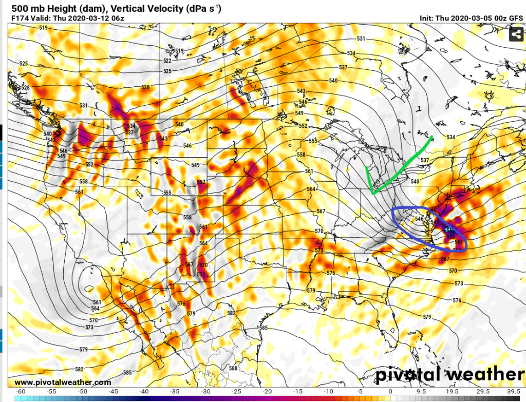
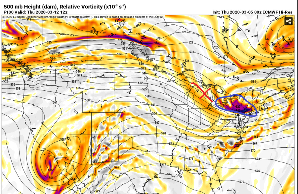
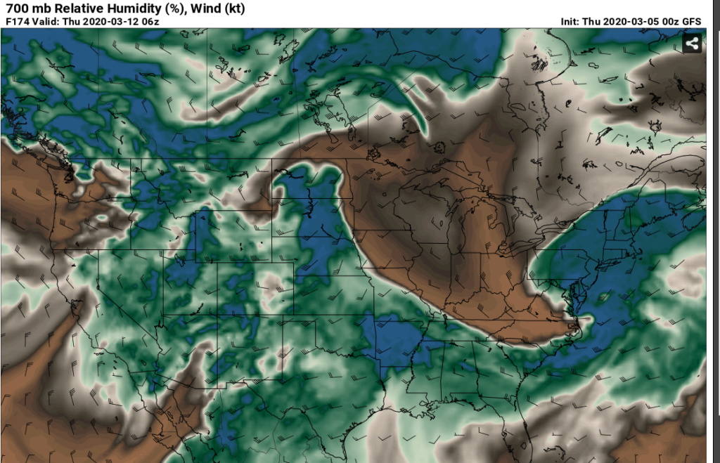
FWIW and it's probably way too early for any op analysis, but season is coming to an end, so why not? The Euro has definitely trended more towards the GFS w.r.t. to 3/12 threat window. Just a few days ago it didn't have the storm. Then it had it, but the short wave energy was way NW of us. Now the short wave energy is "pretty close" (at this range) to where the GFS has it. GFS has been steadfast that it cuts underneath us.
The surface difference between the two is rain (Euro) versus significant snow (GFS).
The differences at this point is the ridge as shown in pictures. GFS has a sharp one allowing for digging trough, while Euro is flat allowing for more northerly trajectory of the short wave. Also noted in both cases the short wave is robust and there is a good connected moisture supply. So ATTM watch it and wait for trends.
GFS
Euro
Moisture supply 700mb
The surface difference between the two is rain (Euro) versus significant snow (GFS).
The differences at this point is the ridge as shown in pictures. GFS has a sharp one allowing for digging trough, while Euro is flat allowing for more northerly trajectory of the short wave. Also noted in both cases the short wave is robust and there is a good connected moisture supply. So ATTM watch it and wait for trends.
GFS

Euro

Moisture supply 700mb

heehaw453- Advanced Forecaster

- Posts : 3906
Reputation : 86
Join date : 2014-01-20
Location : Bedminster Township, PA Elevation 600' ASL
 Re: Long Range Thread 19.0
Speaking of trends, high temps look lovely for the next 10 days

dkodgis- Senior Enthusiast

- Posts : 2560
Reputation : 98
Join date : 2013-12-29
 Re: Long Range Thread 19.0
Where in the great of land of Noah was this this winter?? Snow in April for some, good possibility! Once this breaks down the SE ridge will flex its muscle and we will warm...rapidly. Go from winterish to summer when the breakdown is over.


_________________
Mugs
AKA:King: Snow Weenie
Self Proclaimed
WINTER 2014-15 : 55.12" +.02 for 6 coatings (avg. 35")
WINTER 2015-16 Total - 29.8" (Avg 35")
WINTER 2016-17 : 39.5" so far

amugs- Advanced Forecaster - Mod

- Posts : 15095
Reputation : 213
Join date : 2013-01-07
Age : 54
Location : Hillsdale,NJ
 Re: Long Range Thread 19.0
Hello All
I hope all are staying safe and healthy. Over the past few weeks throughout all of this crisis, I have continued to come back to this site to see how everyone is doing but also to get insight as to when we can expect to get warmer temperatures. Over the past few years, April has been very unstable with cool temperatures and a lot of rain. I was hoping this year would be different but it doesn't look like the trend will change. Anyone out there willing to hazard a guess as to when we will consistently get into the 60s and not raining 4-5 days of the week?
I hope all are staying safe and healthy. Over the past few weeks throughout all of this crisis, I have continued to come back to this site to see how everyone is doing but also to get insight as to when we can expect to get warmer temperatures. Over the past few years, April has been very unstable with cool temperatures and a lot of rain. I was hoping this year would be different but it doesn't look like the trend will change. Anyone out there willing to hazard a guess as to when we will consistently get into the 60s and not raining 4-5 days of the week?

Fededle22- Posts : 169
Reputation : 2
Join date : 2013-03-08
Location : West Orange, NJ
 Re: Long Range Thread 19.0
Freddie looks like the second half of April as of now to latter part.
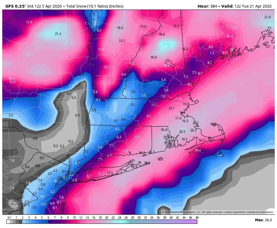
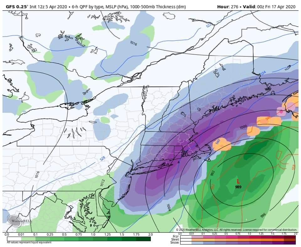
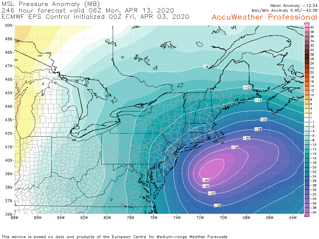
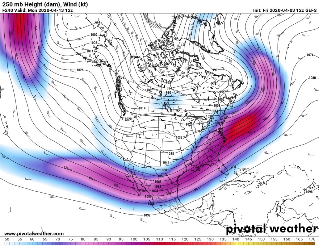
Tjis would be incredible if it were to occur and just might due to the block that is holding in Davis Straights during this time frame. The deep purple map show the jet which would be on roads for this time of year with the polar vortex still hanging about. Where the heck was this in Jan or Feb!!
An intense Nor that is only ...10 days away!!


_________________
Mugs
AKA:King: Snow Weenie
Self Proclaimed
WINTER 2014-15 : 55.12" +.02 for 6 coatings (avg. 35")
WINTER 2015-16 Total - 29.8" (Avg 35")
WINTER 2016-17 : 39.5" so far

amugs- Advanced Forecaster - Mod

- Posts : 15095
Reputation : 213
Join date : 2013-01-07
Age : 54
Location : Hillsdale,NJ
 Re: Long Range Thread 19.0
Here comes the last blast of spring cold
https://twitter.com/jhomenuk/status/1246521780635869186?s=19
https://twitter.com/jhomenuk/status/1246521780635869186?s=19
_________________
Mugs
AKA:King: Snow Weenie
Self Proclaimed
WINTER 2014-15 : 55.12" +.02 for 6 coatings (avg. 35")
WINTER 2015-16 Total - 29.8" (Avg 35")
WINTER 2016-17 : 39.5" so far

amugs- Advanced Forecaster - Mod

- Posts : 15095
Reputation : 213
Join date : 2013-01-07
Age : 54
Location : Hillsdale,NJ

SoulSingMG- Senior Enthusiast

- Posts : 2853
Reputation : 74
Join date : 2013-12-11
Location : Long Island City, NY
 Re: Long Range Thread 19.0
Tomorrow, a lot of rain and wind, wind, wind. Red alert on the wind I think

dkodgis- Senior Enthusiast

- Posts : 2560
Reputation : 98
Join date : 2013-12-29
Page 28 of 28 •  1 ... 15 ... 26, 27, 28
Page 28 of 28
Permissions in this forum:
You cannot reply to topics in this forum|
|
|

 Home
Home
