
 Search
Current date/time is Fri Apr 26, 2024 6:18 pm
Search found 22 matches for polarvortex
Long Range Thread 25.0
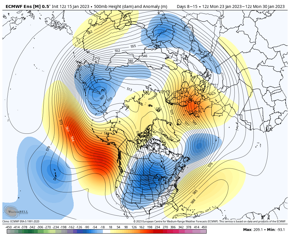
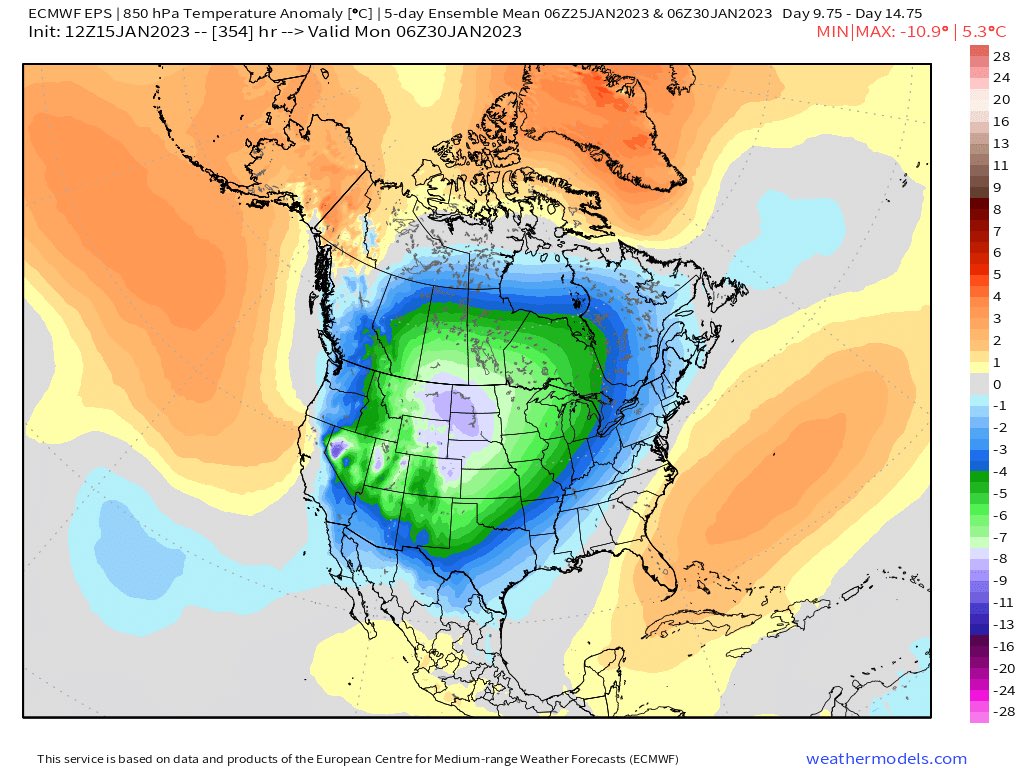
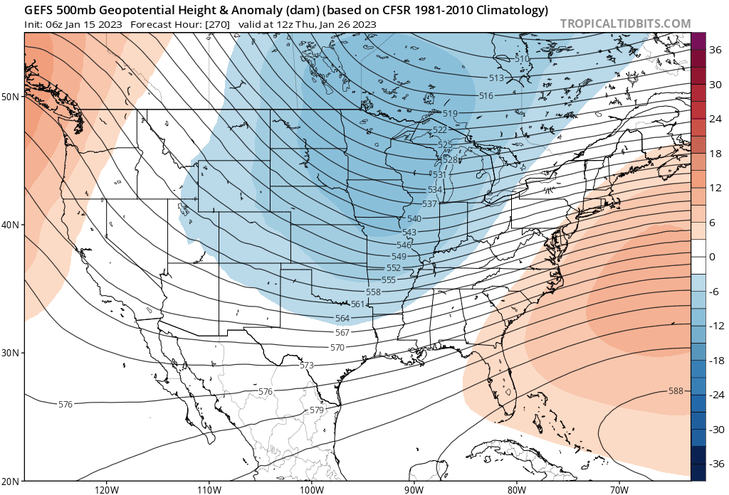
"Houston,...The Eagle has landed." Well maybe not the distance from the earth to the moon but the GFS is predicting that impacts from #PolarVortex disruption currently at 70,000 feet in the atmosphere will reach the surface in two weeks. Blog goes public with update later today. pic.twitter.com/UmEUfMizKq
— Judah Cohen (@judah47) February 15, 2023
End of February and 1st weesk of March we can see these effects - how much remains to be seen. It tries to recover but can't and may take us through April with these effects if it does stabilize and then get destroyed.
- on Wed Feb 15, 2023 12:19 pm
- Search in: Official Weather Talk Thread
- Topic: Long Range Thread 25.0
- Replies: 985
- Views: 83066
Long Range Thread 25.0
If this happens March could be fun. I know the sentiment here and in tjis recoed breaking winter, extreme yes and I have harpes on this for sometime about our weather. It's gonna ramp up. And it's not just IMBY, there is a massive picture of record being broken for everything weather wise.This would be fun.
Wow! The 12z GFS does a double split of the #PolarVortex with 2 waves of #SSW @judah47 @PvForecast #wxtwitter That would be absolutely wild! pic.twitter.com/dkMbaYYxfh
— Mark Margavage (@MeteoMark) February 11, 2023
- on Sat Feb 11, 2023 10:25 pm
- Search in: Official Weather Talk Thread
- Topic: Long Range Thread 25.0
- Replies: 985
- Views: 83066
Long Range Thread 25.0
I hope for an Major Warming. Chance 60-90%!
— Marcel (@Marcel_FFF) February 6, 2023
ECMWF looks good! If it doesn't Work this time, I'll never Trust the Models again for such a period of time.#MajorWarming #ssw #Winter #PolarVortex@judah47 @PvForecast pic.twitter.com/raWsPDZrim

Mom it means that it could majorly disrupt or split the Polar Vortex like it did in Dec but more so 2018 that could bring cold and wintry precipitation conditions to our area for a short ot extended period of time.
- on Mon Feb 06, 2023 10:36 pm
- Search in: Official Weather Talk Thread
- Topic: Long Range Thread 25.0
- Replies: 985
- Views: 83066
Long Range Thread 25.0
For the #PolarVortex (PV) the hits keep coming with the best yet to come from upwelling wave energy from the troposphere. What does this mean for the PV & the impact on our weather? It's serious when I dust off the six-step snow model. The blog now public: https://t.co/Gg8N2KIjJS pic.twitter.com/KBya32hZrn
— Judah Cohen (@judah47) January 18, 2023
This is along that Frank and I have been posting here for a while now. Dr. Lee and Butler are on this as well.
Cohen said, "I am not predicting a split just ....yet"!! That would be interesting if it happens for midish for late Feb.
Time will tell
- on Wed Jan 18, 2023 7:47 pm
- Search in: Official Weather Talk Thread
- Topic: Long Range Thread 25.0
- Replies: 985
- Views: 83066
Long Range Thread 25.0
amugs wrote:All the gloom and doom. Your EPS and GEFS are correcting to squashing the SE Ridge and the PV gets stretched.
1-25ish timeframe to watch.
Good trends since yesterday IMO.Rule of thumb when it gets hot, hot, hot in stratosphere 6-20km above Earth’s surface, right over the North Pole. It can get cold, cold, cold in troposphere, lowest layer of atmosphere where weather happens & where humans live. :flag_us: model really raising eyebrows now. #PolarVortex pic.twitter.com/hBhMc92nDZ
— London & Southeast
(@TheSnowDreamer) January 15, 2023
Yeah Mugs the difference between December's pattern and upcoming one maybe the TPV stretching. If it sets up shop Hudson Bay or a bit to the east then we are in good shape. The NAO won't be able to link up easily with the SER as the TPV trough will pinch it off. Then we get an active winter pattern maybe
- on Mon Jan 16, 2023 8:30 am
- Search in: Official Weather Talk Thread
- Topic: Long Range Thread 25.0
- Replies: 985
- Views: 83066
Long Range Thread 25.0
All the gloom and doom. Your EPS and GEFS are correcting to squashing the SE Ridge and the PV gets stretched.1-25ish timeframe to watch.
Good trends since yesterday IMO.


Rule of thumb when it gets hot, hot, hot in stratosphere 6-20km above Earth’s surface, right over the North Pole. It can get cold, cold, cold in troposphere, lowest layer of atmosphere where weather happens & where humans live. :flag_us: model really raising eyebrows now. #PolarVortex pic.twitter.com/hBhMc92nDZ
— London & Southeast
- on Sun Jan 15, 2023 9:53 pm
- Search in: Official Weather Talk Thread
- Topic: Long Range Thread 25.0
- Replies: 985
- Views: 83066
Long Range Thread 25.0
Here si an ol' adage in the weather world - Thunderstorms today, snow within ten days!! Time will tell but this is promising ....so far. Let's get this to within 100 hours and we'll ramp up excitment!!Geek alert! Polar cap diagnostics more robust on weakening of the #PolarVortex (PV). Geopotential height anomaly forecast predicting full column warming & strong heat flux convergence in the polar stratosphere for next week. Explains accelerating model forecast of a weakening PV. pic.twitter.com/uzvxvAK67K
— Judah Cohen (@judah47) January 13, 2023
Even Dr Cohen is starting to beat the drum, a bit more than a little now.
- on Fri Jan 13, 2023 1:56 pm
- Search in: Official Weather Talk Thread
- Topic: Long Range Thread 25.0
- Replies: 985
- Views: 83066
Long Range Thread 25.0
"If it walks like a duck, quacks like a duck, it's a duck." Models reversing & now showing a stretched #PolarVortex/wave reflection that brings colder weather to eastern North America. #MachineLearning model (has some timing issues) but has trended colder in East US for late Jan. pic.twitter.com/WMeVpJm6kv
— Judah Cohen (@judah47) January 8, 2023
- on Sun Jan 08, 2023 10:33 pm
- Search in: Official Weather Talk Thread
- Topic: Long Range Thread 25.0
- Replies: 985
- Views: 83066
Long Range Thread 25.0
"To reflect/stretch or absorb/SSW that is the question" for the #polarvortex (PV). I've been dumbfounded for weeks but I think I finally figured it out. I discuss what to expect for the PV & the weather impacts possibly thru end of winter. Blog now public: https://t.co/Gg8N2KIjJS pic.twitter.com/Xdmk6HXnlb
— Judah Cohen (@judah47) January 4, 2023
- on Wed Jan 04, 2023 7:28 pm
- Search in: Official Weather Talk Thread
- Topic: Long Range Thread 25.0
- Replies: 985
- Views: 83066
Banter Thread 8.0
The Northern Hemisphere #polarvortex currently has near record low temperatures, but the #GFS at least is showing signs of a large wave-1 event in the coming weeks, accompanied by up to a 30 m/s slowdown and 10-20K warmup. No #SSW predicted yet but something to keep an eye on. pic.twitter.com/Ztp1RiyUce
— Dr. Amy H Butler (@DrAHButler) December 27, 2022
- on Wed Dec 28, 2022 2:44 pm
- Search in: Official Weather Talk Thread
- Topic: Banter Thread 8.0
- Replies: 982
- Views: 49593
Long Range Thread 25.0
Here is your top down SSWE (Sudden Stratospheric Warming event)of the Polar Vortext in motion as perdicted by the GFS. Correlation to the HT (Hunga Tonga)Volcanic WV and particulates from that explosion? Maybe but thisis interesting and exciting to watch unfold.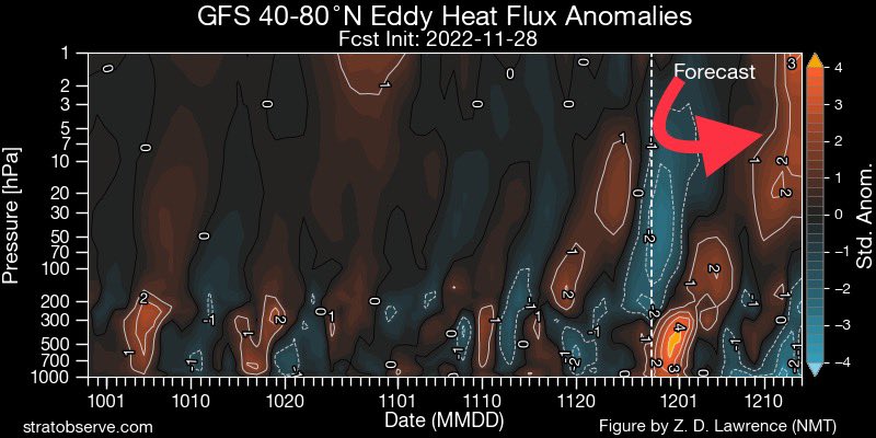
Big change in the European Ensemble forecast for the strength of the #PolarVortex from the 24th to today. On the 24th the ensemble mean was stronger than normal right through. Today it’s weaker than normal with a clustering near record weakness mid-December. #wxtwitter pic.twitter.com/d31qaD3sI2
— Mark Margavage (@MeteoMark) November 28, 2022
Yes you wil hear me harp ALL winter long on this BECAUSE it is again the greatest volcanic event of our modern history dating back to Tambora of 1815.
- on Tue Nov 29, 2022 9:52 am
- Search in: Official Weather Talk Thread
- Topic: Long Range Thread 25.0
- Replies: 985
- Views: 83066
Long Range Thread 25.0
The Stratospheric water vapor injected by the eruption of the Hunga-Tonga Hunga Volcano in Dec 2021 has now made it past 45N. I continue to monitor this as part of ongoing research related to how this anomalously high H2O concentration might impact the #PolarVortex #wxtwitter pic.twitter.com/gQVdDmFmG6
— Mark Margavage (@MeteoMark) November 28, 2022
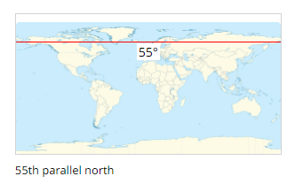
This is moving quite quickly as it was at 20N (Florida the end of August) so it moved 25 degrees lattitude in 2.5 months. By end of December we should be up at the 55 degree lattitudewith this Wv in the atmosphere which is :
This could promote more cold outbreaks and this encircles the globe with its heavy concnertration of water vapor WV which is massive amounts of hear and moisture. As I put in banter that Damien remarked on quite hilariously the amount in gallons is astronomical - rivaling the great flood of Noah's Ark (?) - maybe Doc reemebre this LOL! Also, disrupting the jet structure even further in more of a wavy response to all this is part of the equation. As the warmth rises into the atmosphere it forces the cold downwards just like if you warm the poles the cold air moves away and pshed, floods south. Something to keep an eye on.
- on Mon Nov 28, 2022 10:35 am
- Search in: Official Weather Talk Thread
- Topic: Long Range Thread 25.0
- Replies: 985
- Views: 83066
Long Range Thread 25.0
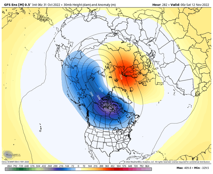
BAMWX
@bamwxcom
(1/3) The stretching the #PolarVortex could certainly make things interesting late November if Greenland blocking signals can verify. Would provide a nice pathway for cold air to dive into CONUS.
- on Mon Oct 31, 2022 4:23 pm
- Search in: Official Weather Talk Thread
- Topic: Long Range Thread 25.0
- Replies: 985
- Views: 83066
Rocktober Obs & Discussions
Okay we may need the LR thread sooner than later this year, we have snow growth, PV, ENSO, PDO, IO Dipole, AMOC, Volcanic effects, signs are abound!!This is interesting to see this early.
"Yo PV let's kick it; stretch, stretch baby; stretch, stretch baby." Can't believe on October 2 we are already up to our second stretched #polarvortex of the season! Responsible for colder weather in Eastern US starting next weekend but does it portend about the upcoming #winter? pic.twitter.com/lG37YmYWRL
— Judah Cohen (@judah47) October 2, 2022
- on Sun Oct 02, 2022 4:24 pm
- Search in: Official Weather Talk Thread
- Topic: Rocktober Obs & Discussions
- Replies: 156
- Views: 6894
Long Range Thread 24.0
"If it looks like a duck, swims like a duck and quacks like a duck, it is probably a duck." Yesterday's ECMWF forecast resembled a reflective event (aka stretched #polarvortex) & today's GFS confirmed it with all the trimmings. Details in the blog: https://t.co/Gg8N2KHLUk pic.twitter.com/SXPOXsZaE2
— Judah Cohen (@judah47) March 16, 2022
Back to winter ??? Possibly as the PV breaks down
- on Wed Mar 16, 2022 4:02 pm
- Search in: Official Weather Talk Thread
- Topic: Long Range Thread 24.0
- Replies: 503
- Views: 21409
Long Range Discussion 23.0
amugs wrote:Was the focus of this week's blog but latest #PolarVortex (PV) animation suggestive of yet another stretched PV in early February that favors #cold/#snow in eastern N America possibly followed by a bigger PV disruption as troposphere becomes more favorable to exciting wave energy pic.twitter.com/8qGuHYPUUU
— Judah Cohen (@judah47) January 25, 2022
Right on cue, baby! Trust the process - all proceeding according to plan
- on Tue Jan 25, 2022 11:15 am
- Search in: Official Weather Talk Thread
- Topic: Long Range Discussion 23.0
- Replies: 641
- Views: 23350
Long Range Discussion 23.0
Was the focus of this week's blog but latest #PolarVortex (PV) animation suggestive of yet another stretched PV in early February that favors #cold/#snow in eastern N America possibly followed by a bigger PV disruption as troposphere becomes more favorable to exciting wave energy pic.twitter.com/8qGuHYPUUU
— Judah Cohen (@judah47) January 25, 2022
- on Tue Jan 25, 2022 11:02 am
- Search in: Official Weather Talk Thread
- Topic: Long Range Discussion 23.0
- Replies: 641
- Views: 23350
Long Range Discussion 22.0
I have found predicting this #winter to be challenging so why should February be any different? GFS has been suggesting a bit more confidently yet another stretched #PolarVortex as we approach February. Would certainly bias #colder East US but cold polar cap heights keep me wary pic.twitter.com/avGQsN7foE
— Judah Cohen (@judah47) January 14, 2022
- on Fri Jan 14, 2022 1:29 pm
- Search in: Official Weather Talk Thread
- Topic: Long Range Discussion 22.0
- Replies: 756
- Views: 31253
Long Range Discussion 22.0
The blog is public. I've been conflicted about the evolution of the pattern across the Northern Hemisphere but I am growing more confident about a stretched #polarvortex, & include a new diagnostic just for this purpose. What are the weather implications? https://t.co/Gg8N2KHLUk pic.twitter.com/jOchkBPdGK
— Judah Cohen (@judah47) December 30, 2021
- on Wed Dec 29, 2021 8:07 pm
- Search in: Official Weather Talk Thread
- Topic: Long Range Discussion 22.0
- Replies: 756
- Views: 31253
Long Range Discussion 22.0
A little early to be sharing the #polarvortex (PV) animation but this morning's GFS predicting an impressive looking PV disruption, especially for so early in the season. To me could potentially favor colder temperatures for northern Eurasia. pic.twitter.com/WpSPPqmsxO
— Judah Cohen (@judah47) October 6, 2021
Mid Month we have blueish colors running across the NE - we shall see how this plays out.
- on Wed Oct 06, 2021 9:16 am
- Search in: Official Weather Talk Thread
- Topic: Long Range Discussion 22.0
- Replies: 756
- Views: 31253
December 2020 Observations and Discussion
from BAMWxThe new GEFS is starting to see a *potential* sudden stratospheric warming event within the next 10 days. As the North Pacific pattern starts to feature some blocking (-EPO) its going to doing some serious work on the #PolarVortex. This is something to watch closely. #natgas
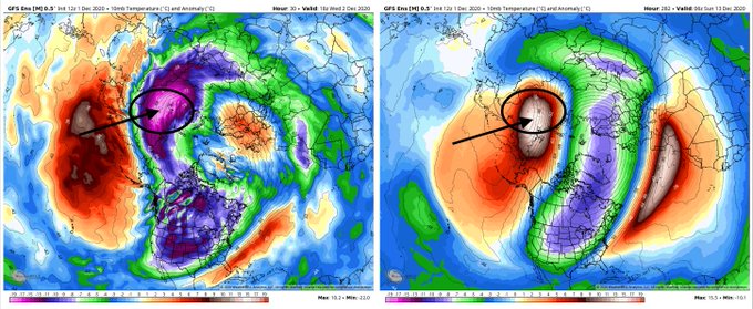
This woudl squeeze the PV and elongate it dropping some cold into the USA as depicted by the above maps. Time will tell for sure but interesting and some good news before the Nina state takes over.
- on Tue Dec 01, 2020 5:51 pm
- Search in: Official Weather Talk Thread
- Topic: December 2020 Observations and Discussion
- Replies: 259
- Views: 12815
Long Range Discussion 20(20) (Ha!)
Morning and Happy Thanksgiving to all a lot of interesting stuff today with regards to the upcoming pattern for December and onwards. It hasn't looked this good for years now and obviously it's still has to verify but there is growing consensus on all guidance of a very favorable pattern change for snow and cold lovers here in the east. Positive PNA signs of a negative AO and negative Nao showing up on guidance through the first half of December. Haven't seen that trifecta in a while which should bring wintry storm chances to our area through the first half of December. Mjo extremely interesting. the Euro basically had it in The Circle of Death for the next month the GFS wants to bring it into 4 5 and 6 today's GFS has it missing 4 heading into 5. The significance of this is if the GFS is correct it will probably cause an Aleutian High Poleward which should disrupt the polar vortex and weaken it as we head towards January as you know it's extremely strong right now also the wave should continue and head through 7/8 and 1 by the time we get to January which could promote very cold and stormy January we'll see how this involves. Also about the polar vortex numerous Mets this morning have stated that long range CVS2 guidance suggest a rapid weakening of the polar vortex late December which would also promote a colder January. If everything holds many Winter forecast will be in jeopardy and this moderate to Strong nina will behave nothing like it interesting times ahead.James Peacock
@peacockreports
(1/2) This surprisingly strong +EAMT has raised my eyebrows for other reasons too: It could set in motion a series of events that perturb the #PolarVortex in the stratosphere, raising potential for a dramatic weakening event (sudden stratospheric warming) some 4-6 weeks from now.
Matt Hugo
@MattHugo81
Plenty of interesting 'goings on': The +EAMT doing its 'thing' now, note the spike in AAM tendancy this likely to be aided by the MJO moving into phases 4-5-6 looking ahead. Decent wave 2 'attack' on the strat as well still forecast. All places emphasis on more blocked patterns.
Simon Lee
@SimonLeeWx
Some continuing suggestions from extended-range models of a weakening trend in the stratospheric vortex mid-December. Today's CFSv2 has 3 members going for a major SSW in January, but more importantly a below-average mean. Eagerly awaiting tonight's ECMWF extended-range!
- on Thu Nov 26, 2020 9:58 am
- Search in: Official Weather Talk Thread
- Topic: Long Range Discussion 20(20) (Ha!)
- Replies: 732
- Views: 31755
