
 Search
March 20th Storm
Page 1 of 4 • 1, 2, 3, 4 ![]()

March 20th Storm
![]() by Frank_Wx Tue Mar 17, 2015 11:26 pm
by Frank_Wx Tue Mar 17, 2015 11:26 pm
I will have a 1st call later tonight but at the moment only thinking a couple of inches on cold surfaces for NYC Metro area. To be honest, minor snow events in March bother me. Useless crap that melts the next day since temps could rebound into the 50's before taking a "dive" again to the 40's next week. That's still below normal this time of year.

00z NAM was about 2-4 inches for the area.
_________________
_______________________________________________________________________________________________________
CLICK HERE to view NJ Strong Snowstorm Classifications

Frank_Wx- Godzilla Seeker

- Posts : 21305
Reputation : 328
Join date : 2013-01-05
Age : 31
Location : Jersey City, NJ -

Re: March 20th Storm
![]() by Guest Tue Mar 17, 2015 11:29 pm
by Guest Tue Mar 17, 2015 11:29 pm
Guest- Guest
oldtimer- Senior Enthusiast

- Posts : 1103
Reputation : 14
Join date : 2013-01-16
Age : 78
Location : Port Jefferson Station Suffolk County
Re: March 20th Storm
![]() by amugs Wed Mar 18, 2015 7:01 am
by amugs Wed Mar 18, 2015 7:01 am


Looks like 4"plus here peeps!
_________________
Mugs
AKA:King: Snow Weenie
Self Proclaimed
WINTER 2014-15 : 55.12" +.02 for 6 coatings (avg. 35")
WINTER 2015-16 Total - 29.8" (Avg 35")
WINTER 2016-17 : 39.5" so far

amugs- Advanced Forecaster - Mod

- Posts : 15093
Reputation : 213
Join date : 2013-01-07
Age : 54
Location : Hillsdale,NJ
Re: March 20th Storm
![]() by sroc4 Wed Mar 18, 2015 7:14 am
by sroc4 Wed Mar 18, 2015 7:14 am
_________________
"In weather and in life, there's no winning and losing; there's only winning and learning."
WINTER 2012/2013 TOTALS 43.65"WINTER 2017/2018 TOTALS 62.85" WINTER 2022/2023 TOTALS 4.9"
WINTER 2013/2014 TOTALS 64.85"WINTER 2018/2019 TOTALS 14.25" WINTER 2023/2024 TOTALS 13.1"
WINTER 2014/2015 TOTALS 71.20"WINTER 2019/2020 TOTALS 6.35"
WINTER 2015/2016 TOTALS 35.00"WINTER 2020/2021 TOTALS 37.75"
WINTER 2016/2017 TOTALS 42.25"WINTER 2021/2022 TOTALS 31.65"

sroc4- Admin
- Posts : 8331
Reputation : 301
Join date : 2013-01-07
Location : Wading River, LI
Re: March 20th Storm
![]() by Frank_Wx Wed Mar 18, 2015 7:34 am
by Frank_Wx Wed Mar 18, 2015 7:34 am

_________________
_______________________________________________________________________________________________________
CLICK HERE to view NJ Strong Snowstorm Classifications
Frank_Wx- Godzilla Seeker
- Posts : 21305
Reputation : 328
Join date : 2013-01-05
Age : 31
Location : Jersey City, NJ -
Re: March 20th Storm
![]() by Frank_Wx Wed Mar 18, 2015 7:36 am
by Frank_Wx Wed Mar 18, 2015 7:36 am

_________________
_______________________________________________________________________________________________________
CLICK HERE to view NJ Strong Snowstorm Classifications
Frank_Wx- Godzilla Seeker
- Posts : 21305
Reputation : 328
Join date : 2013-01-05
Age : 31
Location : Jersey City, NJ -
Re: March 20th Storm
![]() by rb924119 Wed Mar 18, 2015 9:02 am
by rb924119 Wed Mar 18, 2015 9:02 am
Frank_Wx wrote:Jet streak is not in a bad spot, not great either. This could be why precip gets forced into our area despite the track of the surface low
RRRRRRGGGGGGHHHHHHHHHHHHHHH HUMINA HUMINA HUMINA HUMINA HUMINA HUMINA lol
rb924119- Meteorologist

- Posts : 6889
Reputation : 194
Join date : 2013-02-06
Age : 32
Location : Greentown, Pa
Re: March 20th Storm
![]() by sroc4 Wed Mar 18, 2015 9:11 am
by sroc4 Wed Mar 18, 2015 9:11 am
_________________
"In weather and in life, there's no winning and losing; there's only winning and learning."
WINTER 2012/2013 TOTALS 43.65"WINTER 2017/2018 TOTALS 62.85" WINTER 2022/2023 TOTALS 4.9"
WINTER 2013/2014 TOTALS 64.85"WINTER 2018/2019 TOTALS 14.25" WINTER 2023/2024 TOTALS 13.1"
WINTER 2014/2015 TOTALS 71.20"WINTER 2019/2020 TOTALS 6.35"
WINTER 2015/2016 TOTALS 35.00"WINTER 2020/2021 TOTALS 37.75"
WINTER 2016/2017 TOTALS 42.25"WINTER 2021/2022 TOTALS 31.65"
sroc4- Admin
- Posts : 8331
Reputation : 301
Join date : 2013-01-07
Location : Wading River, LI
Re: March 20th Storm
![]() by rb924119 Wed Mar 18, 2015 9:20 am
by rb924119 Wed Mar 18, 2015 9:20 am
sroc4 wrote:Hey rb or whomever. Do you recall where the discussion about the jet streak quadrants that rb wrote up are. If so can seine let me know?
It starts here and then goes through a few more of the following pages. I think there's also another discussion about other synoptic-scale forcing here too. I can't remember, though lol
https://www.njstrongweatherforum.com/t496p50-sunday-monday-snowstorm-2nd-call-snow-map
rb924119- Meteorologist
- Posts : 6889
Reputation : 194
Join date : 2013-02-06
Age : 32
Location : Greentown, Pa
Re: March 20th Storm
![]() by rb924119 Wed Mar 18, 2015 9:23 am
by rb924119 Wed Mar 18, 2015 9:23 am
rb924119 wrote:sroc4 wrote:Hey rb or whomever. Do you recall where the discussion about the jet streak quadrants that rb wrote up are. If so can seine let me know?
It starts here and then goes through a few more of the following pages. I think there's also another discussion about other synoptic-scale forcing here too. I can't remember, though lol
https://www.njstrongweatherforum.com/t496p50-sunday-monday-snowstorm-2nd-call-snow-map
Here's the second discussion:
https://www.njstrongweatherforum.com/t496p150-sunday-monday-snowstorm-2nd-call-snow-map
rb924119- Meteorologist
- Posts : 6889
Reputation : 194
Join date : 2013-02-06
Age : 32
Location : Greentown, Pa
Re: March 20th Storm
![]() by algae888 Wed Mar 18, 2015 11:21 am
by algae888 Wed Mar 18, 2015 11:21 am

algae888- Advanced Forecaster

- Posts : 5311
Reputation : 46
Join date : 2013-02-05
Age : 61
Location : mt. vernon, new york
Re: March 20th Storm
![]() by Frank_Wx Wed Mar 18, 2015 11:55 am
by Frank_Wx Wed Mar 18, 2015 11:55 am
_________________
_______________________________________________________________________________________________________
CLICK HERE to view NJ Strong Snowstorm Classifications
Frank_Wx- Godzilla Seeker
- Posts : 21305
Reputation : 328
Join date : 2013-01-05
Age : 31
Location : Jersey City, NJ -
Re: March 20th Storm
![]() by sroc4 Wed Mar 18, 2015 11:57 am
by sroc4 Wed Mar 18, 2015 11:57 am
Frank_Wx wrote:12z GFS was impressive. 3-6/4-8 ordeal could be in order for us.
The energy at H5 looked much better(more amped) this run. We will see how the rest of the models unfold today.
_________________
"In weather and in life, there's no winning and losing; there's only winning and learning."
WINTER 2012/2013 TOTALS 43.65"WINTER 2017/2018 TOTALS 62.85" WINTER 2022/2023 TOTALS 4.9"
WINTER 2013/2014 TOTALS 64.85"WINTER 2018/2019 TOTALS 14.25" WINTER 2023/2024 TOTALS 13.1"
WINTER 2014/2015 TOTALS 71.20"WINTER 2019/2020 TOTALS 6.35"
WINTER 2015/2016 TOTALS 35.00"WINTER 2020/2021 TOTALS 37.75"
WINTER 2016/2017 TOTALS 42.25"WINTER 2021/2022 TOTALS 31.65"
sroc4- Admin
- Posts : 8331
Reputation : 301
Join date : 2013-01-07
Location : Wading River, LI
Re: March 20th Storm
![]() by algae888 Wed Mar 18, 2015 12:17 pm
by algae888 Wed Mar 18, 2015 12:17 pm
algae888- Advanced Forecaster
- Posts : 5311
Reputation : 46
Join date : 2013-02-05
Age : 61
Location : mt. vernon, new york
Re: March 20th Storm
![]() by amugs Wed Mar 18, 2015 12:18 pm
by amugs Wed Mar 18, 2015 12:18 pm
_________________
Mugs
AKA:King: Snow Weenie
Self Proclaimed
WINTER 2014-15 : 55.12" +.02 for 6 coatings (avg. 35")
WINTER 2015-16 Total - 29.8" (Avg 35")
WINTER 2016-17 : 39.5" so far
amugs- Advanced Forecaster - Mod
- Posts : 15093
Reputation : 213
Join date : 2013-01-07
Age : 54
Location : Hillsdale,NJ
Re: March 20th Storm
![]() by algae888 Wed Mar 18, 2015 12:20 pm
by algae888 Wed Mar 18, 2015 12:20 pm
algae888- Advanced Forecaster
- Posts : 5311
Reputation : 46
Join date : 2013-02-05
Age : 61
Location : mt. vernon, new york
Re: March 20th Storm
![]() by jmanley32 Wed Mar 18, 2015 12:21 pm
by jmanley32 Wed Mar 18, 2015 12:21 pm

jmanley32- Senior Enthusiast
- Posts : 20513
Reputation : 108
Join date : 2013-12-12
Age : 42
Location : Yonkers, NY
Re: March 20th Storm
![]() by algae888 Wed Mar 18, 2015 12:22 pm
by algae888 Wed Mar 18, 2015 12:22 pm
algae888- Advanced Forecaster
- Posts : 5311
Reputation : 46
Join date : 2013-02-05
Age : 61
Location : mt. vernon, new york
Re: March 20th Storm
![]() by amugs Wed Mar 18, 2015 12:26 pm
by amugs Wed Mar 18, 2015 12:26 pm
jmanley32 wrote:Although ground had warmed the muddy areas are freezing over again so it may have a chance to stick, if it stays cold enough maybe even to roads too.
It will jman with this cold air in place.
_________________
Mugs
AKA:King: Snow Weenie
Self Proclaimed
WINTER 2014-15 : 55.12" +.02 for 6 coatings (avg. 35")
WINTER 2015-16 Total - 29.8" (Avg 35")
WINTER 2016-17 : 39.5" so far
amugs- Advanced Forecaster - Mod
- Posts : 15093
Reputation : 213
Join date : 2013-01-07
Age : 54
Location : Hillsdale,NJ
Re: March 20th Storm
![]() by amugs Wed Mar 18, 2015 12:31 pm
by amugs Wed Mar 18, 2015 12:31 pm


_________________
Mugs
AKA:King: Snow Weenie
Self Proclaimed
WINTER 2014-15 : 55.12" +.02 for 6 coatings (avg. 35")
WINTER 2015-16 Total - 29.8" (Avg 35")
WINTER 2016-17 : 39.5" so far
amugs- Advanced Forecaster - Mod
- Posts : 15093
Reputation : 213
Join date : 2013-01-07
Age : 54
Location : Hillsdale,NJ
Re: March 20th Storm
![]() by sroc4 Wed Mar 18, 2015 12:34 pm
by sroc4 Wed Mar 18, 2015 12:34 pm
algae888 wrote:this system is starting to resemble the March 1st and March 5th systems actually it looks like we're back in the same pattern, after seven to ten day break ,which started February 1st.
Check out my post from March 5th. 15days ago!
by sroc4 on Thu Mar 05, 2015 11:28 am
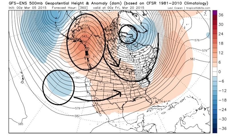
Im sorry I cant help myself, but just look at this for March 20th. Euro, GFS, and Canadian ensembles 500mb height anomalies respectively. I said it before and Ill say it again. The -EPO is rebuilding coupled with the +PNA potentially; all because the warmer than normal SST off the west coast of NA. The negatives (blue colors) out in the pacific off the western CONUS will be shooting energy along the STJ. While the Alaskan Ridging (-EPO signal) will be sending strong Arctic HP south leading to a trough in the east. Now keep in mind that climatology this time of year will moderate the arctic air as it gets further south relative to what we have experienced thus far this winter, but the source region of the air mass is arctic as depicted here. The possibility of a similar set up to what we are seeing now, or the possibility of a true Nor Easter if there is Northern energy that is timed right with southern energy and phases is a possibility from March 19th-24Th. Im just saying
 " />
" /> " />
" /> " />
" />_________________
"In weather and in life, there's no winning and losing; there's only winning and learning."
WINTER 2012/2013 TOTALS 43.65"WINTER 2017/2018 TOTALS 62.85" WINTER 2022/2023 TOTALS 4.9"
WINTER 2013/2014 TOTALS 64.85"WINTER 2018/2019 TOTALS 14.25" WINTER 2023/2024 TOTALS 13.1"
WINTER 2014/2015 TOTALS 71.20"WINTER 2019/2020 TOTALS 6.35"
WINTER 2015/2016 TOTALS 35.00"WINTER 2020/2021 TOTALS 37.75"
WINTER 2016/2017 TOTALS 42.25"WINTER 2021/2022 TOTALS 31.65"
sroc4- Admin
- Posts : 8331
Reputation : 301
Join date : 2013-01-07
Location : Wading River, LI
Re: March 20th Storm
![]() by algae888 Wed Mar 18, 2015 12:44 pm
by algae888 Wed Mar 18, 2015 12:44 pm
algae888- Advanced Forecaster
- Posts : 5311
Reputation : 46
Join date : 2013-02-05
Age : 61
Location : mt. vernon, new york
Re: March 20th Storm
![]() by NjWeatherGuy Wed Mar 18, 2015 1:35 pm
by NjWeatherGuy Wed Mar 18, 2015 1:35 pm

NjWeatherGuy- Advanced Forecaster
- Posts : 4100
Reputation : 28
Join date : 2013-01-06
Location : Belle Mead, NJ
Re: March 20th Storm
![]() by amugs Wed Mar 18, 2015 1:38 pm
by amugs Wed Mar 18, 2015 1:38 pm
AMEN!!!
_________________
Mugs
AKA:King: Snow Weenie
Self Proclaimed
WINTER 2014-15 : 55.12" +.02 for 6 coatings (avg. 35")
WINTER 2015-16 Total - 29.8" (Avg 35")
WINTER 2016-17 : 39.5" so far
amugs- Advanced Forecaster - Mod
- Posts : 15093
Reputation : 213
Join date : 2013-01-07
Age : 54
Location : Hillsdale,NJ
Page 1 of 4 • 1, 2, 3, 4 ![]()
|
|
|