
 Search
2016 Tropical Cyclone Discussions
Page 14 of 33 •  1 ... 8 ... 13, 14, 15 ... 23 ... 33
 ![]()
Re: 2016 Tropical Cyclone Discussions
![]() by Snow88 Fri Aug 26, 2016 1:02 pm
by Snow88 Fri Aug 26, 2016 1:02 pm
Snow88- Senior Enthusiast

- Posts : 2193
Join date : 2013-01-09
Re: 2016 Tropical Cyclone Discussions
![]() by Snow88 Fri Aug 26, 2016 1:03 pm
by Snow88 Fri Aug 26, 2016 1:03 pm
jmanley32 wrote:LR likes to give us a spook (just for entertainment, since as we have seen models have been less than accurate even within the 5 day), well if GFS is right about 99L, will have to wonder about this one as it has been on and off with the models past few days as a large hurricane north of islands and heading north, no quick recurve. This looks like if its going to get marked by the NHC it would be around Tuesday as when it is showing on GFS to come off Africa. Has a decent chance IMO if it comes to fruition, rather than the past few storms.
12z still has it
Snow88- Senior Enthusiast
- Posts : 2193
Join date : 2013-01-09
Re: 2016 Tropical Cyclone Discussions
![]() by jmanley32 Fri Aug 26, 2016 1:23 pm
by jmanley32 Fri Aug 26, 2016 1:23 pm

jmanley32- Senior Enthusiast
- Posts : 20516
Reputation : 108
Join date : 2013-12-12
Age : 42
Location : Yonkers, NY
Re: 2016 Tropical Cyclone Discussions
![]() by jmanley32 Fri Aug 26, 2016 1:27 pm
by jmanley32 Fri Aug 26, 2016 1:27 pm
jmanley32- Senior Enthusiast
- Posts : 20516
Reputation : 108
Join date : 2013-12-12
Age : 42
Location : Yonkers, NY
Re: 2016 Tropical Cyclone Discussions
![]() by Snow88 Fri Aug 26, 2016 1:38 pm
by Snow88 Fri Aug 26, 2016 1:38 pm
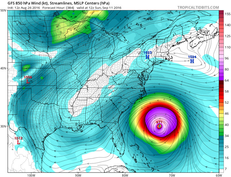
http://www.tropicaltidbits.com/analysis/models/?model=hwrf®ion=99L&pkg=ref&runtime=2016082612&fh=105&xpos=0&ypos=944
Sub 960 low at hour 105 in the gulf
Wow

Snow88- Senior Enthusiast
- Posts : 2193
Reputation : 4
Join date : 2013-01-09
Age : 35
Location : Brooklyn, NY
Re: 2016 Tropical Cyclone Discussions
![]() by Snow88 Fri Aug 26, 2016 1:44 pm
by Snow88 Fri Aug 26, 2016 1:44 pm
949 low
Hour 114
http://www.tropicaltidbits.com/analysis/models/?model=hwrf®ion=99L&pkg=ref&runtime=2016082612&fh=114&xpos=0&ypos=699
Snow88- Senior Enthusiast
- Posts : 2193
Reputation : 4
Join date : 2013-01-09
Age : 35
Location : Brooklyn, NY
Re: 2016 Tropical Cyclone Discussions
![]() by sroc4 Fri Aug 26, 2016 2:12 pm
by sroc4 Fri Aug 26, 2016 2:12 pm


_________________
"In weather and in life, there's no winning and losing; there's only winning and learning."
WINTER 2012/2013 TOTALS 43.65"WINTER 2017/2018 TOTALS 62.85" WINTER 2022/2023 TOTALS 4.9"
WINTER 2013/2014 TOTALS 64.85"WINTER 2018/2019 TOTALS 14.25" WINTER 2023/2024 TOTALS 13.1"
WINTER 2014/2015 TOTALS 71.20"WINTER 2019/2020 TOTALS 6.35"
WINTER 2015/2016 TOTALS 35.00"WINTER 2020/2021 TOTALS 37.75"
WINTER 2016/2017 TOTALS 42.25"WINTER 2021/2022 TOTALS 31.65"

sroc4- Admin

- Posts : 8331
Reputation : 301
Join date : 2013-01-07
Location : Wading River, LI
Re: 2016 Tropical Cyclone Discussions
![]() by jmanley32 Fri Aug 26, 2016 2:36 pm
by jmanley32 Fri Aug 26, 2016 2:36 pm
sroc4 wrote:Just throwing this out there. There is currently a newly formed center of circulation somehwre withing the circle in the still image. You can clearly see it on the loop. But for the first time in a long time there is convection firing up very near or just east to this center. Wind shear has dropped off drastically. Im not jumping any guns here but I said it before and Ill say it again...dont fall asleep on 99L just yet. The last 48hrs of runs "could" be part of the windshield wiper effect.
sroc, I think that's the original circulation with convection firing around it, if you follow the path it took it would be right around there. Oh and my post about the CMC, that's not even 99L that's off EC, that's some other rogue LP it decides to develop, crazy uncle lol
jmanley32- Senior Enthusiast
- Posts : 20516
Reputation : 108
Join date : 2013-12-12
Age : 42
Location : Yonkers, NY
Re: 2016 Tropical Cyclone Discussions
![]() by nutleyblizzard Fri Aug 26, 2016 2:37 pm
by nutleyblizzard Fri Aug 26, 2016 2:37 pm


nutleyblizzard- Senior Enthusiast
- Posts : 1952
Reputation : 41
Join date : 2014-01-30
Age : 58
Location : Nutley, new jersey
Re: 2016 Tropical Cyclone Discussions
![]() by jmanley32 Fri Aug 26, 2016 2:40 pm
by jmanley32 Fri Aug 26, 2016 2:40 pm
jmanley32- Senior Enthusiast
- Posts : 20516
Reputation : 108
Join date : 2013-12-12
Age : 42
Location : Yonkers, NY
Re: 2016 Tropical Cyclone Discussions
![]() by jmanley32 Fri Aug 26, 2016 2:41 pm
by jmanley32 Fri Aug 26, 2016 2:41 pm
nutleyblizzard wrote:
I just got home to check up on the wave myself. Yep Sroc I see what you mean. To my untrained eyes it looks like the convection is just east of the center. I thought early this morning it was done for, but we got a fighter on our hands. It just needs to hang in there a bit longer till it moves into a more favorable area with less shear. Some of the 12z models are hinting at a strong cane. We'll see.
Whatever it does or des not become this has to be the longest invest I have ever tracked that hasn't developed yet
jmanley32- Senior Enthusiast
- Posts : 20516
Reputation : 108
Join date : 2013-12-12
Age : 42
Location : Yonkers, NY
Re: 2016 Tropical Cyclone Discussions
![]() by sroc4 Fri Aug 26, 2016 2:44 pm
by sroc4 Fri Aug 26, 2016 2:44 pm
nutleyblizzard wrote:I just got home to check up on the wave myself. Yep Sroc I see what you mean. To my untrained eyes it looks like the convection is just east of the center. I thought early this morning it was done for, but we got a fighter on our hands. It just needs to hang in there a bit longer till it moves into a more favorable area with less shear. Some of the 12z models are hinting at a strong cane. We'll see.
If you look at the map above there is a mere 5-10kt shear over top. A far cry from the 30-40kts it had been experiencing. Problem I think is in the upper levels. There is only marginal divergence aloft. And I still think there is some mid level dry air mixing in.
_________________
"In weather and in life, there's no winning and losing; there's only winning and learning."
WINTER 2012/2013 TOTALS 43.65"WINTER 2017/2018 TOTALS 62.85" WINTER 2022/2023 TOTALS 4.9"
WINTER 2013/2014 TOTALS 64.85"WINTER 2018/2019 TOTALS 14.25" WINTER 2023/2024 TOTALS 13.1"
WINTER 2014/2015 TOTALS 71.20"WINTER 2019/2020 TOTALS 6.35"
WINTER 2015/2016 TOTALS 35.00"WINTER 2020/2021 TOTALS 37.75"
WINTER 2016/2017 TOTALS 42.25"WINTER 2021/2022 TOTALS 31.65"
sroc4- Admin
- Posts : 8331
Reputation : 301
Join date : 2013-01-07
Location : Wading River, LI
Re: 2016 Tropical Cyclone Discussions
![]() by jmanley32 Fri Aug 26, 2016 7:33 pm
by jmanley32 Fri Aug 26, 2016 7:33 pm

jmanley32- Senior Enthusiast
- Posts : 20516
Reputation : 108
Join date : 2013-12-12
Age : 42
Location : Yonkers, NY
jmanley32- Senior Enthusiast
- Posts : 20516
Reputation : 108
Join date : 2013-12-12
Age : 42
Location : Yonkers, NY
Re: 2016 Tropical Cyclone Discussions
![]() by jmanley32 Fri Aug 26, 2016 7:35 pm
by jmanley32 Fri Aug 26, 2016 7:35 pm
jmanley32- Senior Enthusiast
- Posts : 20516
Reputation : 108
Join date : 2013-12-12
Age : 42
Location : Yonkers, NY
Re: 2016 Tropical Cyclone Discussions
![]() by jmanley32 Fri Aug 26, 2016 7:56 pm
by jmanley32 Fri Aug 26, 2016 7:56 pm
Edit" 91L is ex Fiona!

jmanley32- Senior Enthusiast
- Posts : 20516
Reputation : 108
Join date : 2013-12-12
Age : 42
Location : Yonkers, NY
Re: 2016 Tropical Cyclone Discussions
![]() by Frank_Wx Fri Aug 26, 2016 8:23 pm
by Frank_Wx Fri Aug 26, 2016 8:23 pm
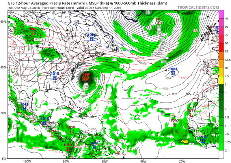
jmanley32 wrote:18z GFS, 12z Euro and ensembles all have what I believe is going to be 90L coming off Africa on or around 30th. It seems to want to take a trek across entire atlantic and up the east coast (just offshore) and on 18z gets down to 979 mb and then on the last frame in fantasyland stalls off cape cod and starts to head west, is that because of the high blocking it in the image below? I also posted 240 hrs, so at least we are not completely in fantasy land, I think THIS one may be one WE need to watch closely, and other forums are talking about it too (of course I only lurk there, you guys are my peeps lol).
GFS H5 actually shows a positive NAO with a ridge pushing into the east. That would call for an OTS track. We won't really have a good idea until this time next week.
_________________
_______________________________________________________________________________________________________
CLICK HERE to view NJ Strong Snowstorm Classifications

Frank_Wx- Godzilla Seeker
- Posts : 21305
Reputation : 328
Join date : 2013-01-05
Age : 31
Location : Jersey City, NJ -

Re: 2016 Tropical Cyclone Discussions
![]() by Joe Snow Sat Aug 27, 2016 1:05 am
by Joe Snow Sat Aug 27, 2016 1:05 am
jmanley32 wrote:Joesnow, I seen your on storm2k, how is it over there, seems like they can get a bit nasty but I like their insight for the tropics. A lot of crazy rules. 160 pages though on 99L models wow.
I love weather and storms. The site is OK tough to break in as a nebie. Crazy rules but it does keep it straight forward. I mostly post here because it's friendly and helpful the detailed expiations etc. great bunch of Weather Weenies here.
They do have some great insight but 160 pages of everyone's interpretation of the latest model runs is a bit over done.

Joe Snow- Pro Enthusiast

- Posts : 924
Reputation : 7
Join date : 2014-02-12
Age : 62
Location : Sanford Florida, Fmrly Kings Park, NY
Re: 2016 Tropical Cyclone Discussions
![]() by NjWeatherGuy Sat Aug 27, 2016 3:06 am
by NjWeatherGuy Sat Aug 27, 2016 3:06 am

NjWeatherGuy- Advanced Forecaster

- Posts : 4100
Reputation : 28
Join date : 2013-01-06
Location : Belle Mead, NJ
Re: 2016 Tropical Cyclone Discussions
![]() by skinsfan1177 Sat Aug 27, 2016 9:40 am
by skinsfan1177 Sat Aug 27, 2016 9:40 am

skinsfan1177- Senior Enthusiast
- Posts : 4485
Reputation : 35
Join date : 2013-01-07
Age : 46
Location : Point Pleasant Boro
Re: 2016 Tropical Cyclone Discussions
![]() by NjWeatherGuy Sat Aug 27, 2016 10:20 am
by NjWeatherGuy Sat Aug 27, 2016 10:20 am
skinsfan1177 wrote:What's with this 91L firing up by Bermuda drifting towards Carolina coast next 3 days
Believe it might be remnants of Fiona that just may rekindle under very warm gulf stream temps and less wind shear and dry air in the future which killed Fiona and is putting a hurt on 99L. Thought the CMC was on crack showing 3 tropical storms in close proximity, 99L in the gulf, this one near the coast around the carolinas, and Gaston bombed out in the central-eastern Atlantic.
NjWeatherGuy- Advanced Forecaster
- Posts : 4100
Reputation : 28
Join date : 2013-01-06
Location : Belle Mead, NJ
Re: 2016 Tropical Cyclone Discussions
![]() by sroc4 Sat Aug 27, 2016 2:37 pm
by sroc4 Sat Aug 27, 2016 2:37 pm
http://www.tropicaltidbits.com/
_________________
"In weather and in life, there's no winning and losing; there's only winning and learning."
WINTER 2012/2013 TOTALS 43.65"WINTER 2017/2018 TOTALS 62.85" WINTER 2022/2023 TOTALS 4.9"
WINTER 2013/2014 TOTALS 64.85"WINTER 2018/2019 TOTALS 14.25" WINTER 2023/2024 TOTALS 13.1"
WINTER 2014/2015 TOTALS 71.20"WINTER 2019/2020 TOTALS 6.35"
WINTER 2015/2016 TOTALS 35.00"WINTER 2020/2021 TOTALS 37.75"
WINTER 2016/2017 TOTALS 42.25"WINTER 2021/2022 TOTALS 31.65"
sroc4- Admin
- Posts : 8331
Reputation : 301
Join date : 2013-01-07
Location : Wading River, LI
Re: 2016 Tropical Cyclone Discussions
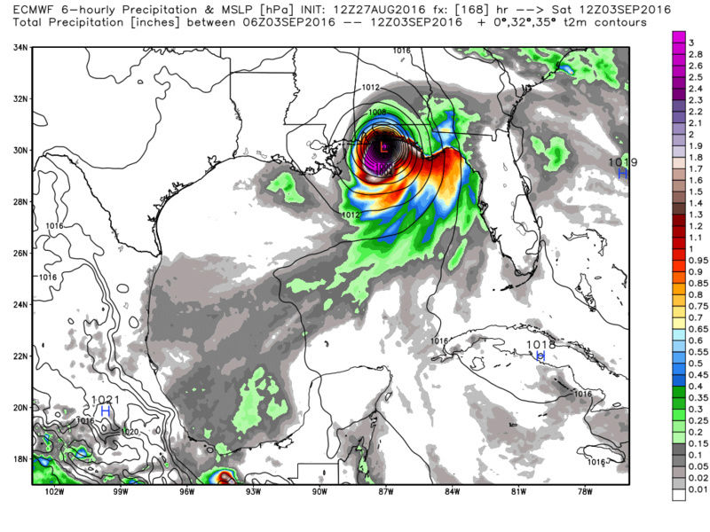
![]() by sroc4 Sat Aug 27, 2016 2:43 pm
by sroc4 Sat Aug 27, 2016 2:43 pm

Last edited by sroc4 on Sat Aug 27, 2016 2:44 pm; edited 1 time in total
_________________
"In weather and in life, there's no winning and losing; there's only winning and learning."
WINTER 2012/2013 TOTALS 43.65"WINTER 2017/2018 TOTALS 62.85" WINTER 2022/2023 TOTALS 4.9"
WINTER 2013/2014 TOTALS 64.85"WINTER 2018/2019 TOTALS 14.25" WINTER 2023/2024 TOTALS 13.1"
WINTER 2014/2015 TOTALS 71.20"WINTER 2019/2020 TOTALS 6.35"
WINTER 2015/2016 TOTALS 35.00"WINTER 2020/2021 TOTALS 37.75"
WINTER 2016/2017 TOTALS 42.25"WINTER 2021/2022 TOTALS 31.65"
sroc4- Admin
- Posts : 8331
Reputation : 301
Join date : 2013-01-07
Location : Wading River, LI
Re: 2016 Tropical Cyclone Discussions
![]() by algae888 Sat Aug 27, 2016 2:43 pm
by algae888 Sat Aug 27, 2016 2:43 pm

algae888- Advanced Forecaster
- Posts : 5311
Reputation : 46
Join date : 2013-02-05
Age : 61
Location : mt. vernon, new york
Re: 2016 Tropical Cyclone Discussions
![]() by sroc4 Sat Aug 27, 2016 2:45 pm
by sroc4 Sat Aug 27, 2016 2:45 pm
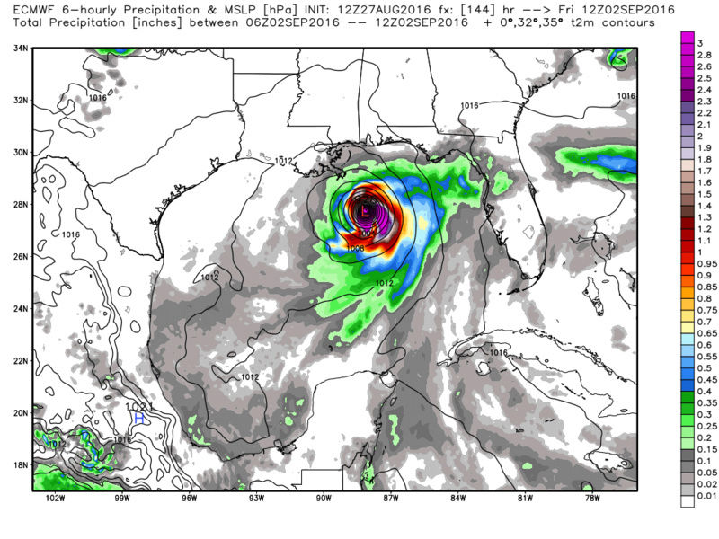
algae888 wrote:Scott also the euro now develops 99 L into a hurricane in hits the panhandle of Florida. I'm assuming that's about a cat 2
Yup see above. Ive been saying it for awhile. Cant fall asleep yet
_________________
"In weather and in life, there's no winning and losing; there's only winning and learning."
WINTER 2012/2013 TOTALS 43.65"WINTER 2017/2018 TOTALS 62.85" WINTER 2022/2023 TOTALS 4.9"
WINTER 2013/2014 TOTALS 64.85"WINTER 2018/2019 TOTALS 14.25" WINTER 2023/2024 TOTALS 13.1"
WINTER 2014/2015 TOTALS 71.20"WINTER 2019/2020 TOTALS 6.35"
WINTER 2015/2016 TOTALS 35.00"WINTER 2020/2021 TOTALS 37.75"
WINTER 2016/2017 TOTALS 42.25"WINTER 2021/2022 TOTALS 31.65"
sroc4- Admin
- Posts : 8331
Reputation : 301
Join date : 2013-01-07
Location : Wading River, LI
Re: 2016 Tropical Cyclone Discussions
![]() by algae888 Sat Aug 27, 2016 2:48 pm
by algae888 Sat Aug 27, 2016 2:48 pm
I agree. Any low pressure in the Gulf or along the Eastern Seaboard has to be watched carefully as models probably won't have a great handle on it until we're under 72 hourssroc4 wrote:algae888 wrote:Scott also the euro now develops 99 L into a hurricane in hits the panhandle of Florida. I'm assuming that's about a cat 2
Yup see above. Ive been saying it for awhile. Cant fall asleep yet
algae888- Advanced Forecaster
- Posts : 5311
Reputation : 46
Join date : 2013-02-05
Age : 61
Location : mt. vernon, new york
Re: 2016 Tropical Cyclone Discussions
![]() by Frank_Wx Sat Aug 27, 2016 2:51 pm
by Frank_Wx Sat Aug 27, 2016 2:51 pm

_________________
_______________________________________________________________________________________________________
CLICK HERE to view NJ Strong Snowstorm Classifications
Frank_Wx- Godzilla Seeker
- Posts : 21305
Reputation : 328
Join date : 2013-01-05
Age : 31
Location : Jersey City, NJ -
Page 14 of 33 • 1 ... 8 ... 13, 14, 15 ... 23 ... 33 ![]()
|
|
|