
 Search
Long Range Thread 12.0
Page 19 of 40 •  1 ... 11 ... 18, 19, 20 ... 29 ... 40
 ![]()
Re: Long Range Thread 12.0
![]() by Frank_Wx Sun Nov 13, 2016 10:58 pm
by Frank_Wx Sun Nov 13, 2016 10:58 pm

Frank_Wx- Godzilla Seeker

- Posts : 21305
Join date : 2013-01-05 -

Re: Long Range Thread 12.0
![]() by Frank_Wx Sun Nov 13, 2016 11:00 pm
by Frank_Wx Sun Nov 13, 2016 11:00 pm
Frank_Wx- Godzilla Seeker
- Posts : 21305
Join date : 2013-01-05 -
Re: Long Range Thread 12.0
![]() by Frank_Wx Sun Nov 13, 2016 11:11 pm
by Frank_Wx Sun Nov 13, 2016 11:11 pm
_________________
_______________________________________________________________________________________________________
CLICK HERE to view NJ Strong Snowstorm Classifications

Frank_Wx- Godzilla Seeker
- Posts : 21305
Reputation : 328
Join date : 2013-01-05
Age : 31
Location : Jersey City, NJ -
Re: Long Range Thread 12.0
![]() by Frank_Wx Sun Nov 13, 2016 11:36 pm
by Frank_Wx Sun Nov 13, 2016 11:36 pm
A lot of concern has been expressed at what's showing in the long range. Ensembles show endless ridging over North America, an active Pacific Jet aiding in +EPO/-PNA conditions, and a robust southeast ridge. La Nina is going to make an impact sooner than later, and that's to be expected since dynamical models had it peaking mid to late November. Although we'll see intrusions of troughs over the northeast this month, even one around Thanksgiving that could bring snow to northern areas, the cold will be moderated since it's not sourced from the Arctic.
Keep in mind what I said about the Stratosphere a couple of days ago. Westerly winds are still projected to reverse easterly around Thanksgiving. That is usually step 2 in advancing toward a SSWE. Step 1 was developing a snowpack over Siberia, of which there is. The EURO shows SSW around Thanksgiving and it's fairly impressive. As long as there is not a lobe that remains over Greenland we have a chance of seeing a decent -AO and possible -NAO pattern developing for the very end of Nov but most likely early December.
So while signals look depressing on the surface of our atmosphere, it's a bit more optimistic a layer above us and hopefully that transcends into good news for an early start to winter. I do have reservations about January / February though. We'll take this a step at a time.
_________________
_______________________________________________________________________________________________________
CLICK HERE to view NJ Strong Snowstorm Classifications
Frank_Wx- Godzilla Seeker
- Posts : 21305
Reputation : 328
Join date : 2013-01-05
Age : 31
Location : Jersey City, NJ -
Re: Long Range Thread 12.0
![]() by sroc4 Mon Nov 14, 2016 7:24 am
by sroc4 Mon Nov 14, 2016 7:24 am
Frank_Wx wrote:Discussion from Facebook
A lot of concern has been expressed at what's showing in the long range. Ensembles show endless ridging over North America, an active Pacific Jet aiding in +EPO/-PNA conditions, and a robust southeast ridge. La Nina is going to make an impact sooner than later, and that's to be expected since dynamical models had it peaking mid to late November. Although we'll see intrusions of troughs over the northeast this month, even one around Thanksgiving that could bring snow to northern areas, the cold will be moderated since it's not sourced from the Arctic.
Keep in mind what I said about the Stratosphere a couple of days ago. Westerly winds are still projected to reverse easterly around Thanksgiving. That is usually step 2 in advancing toward a SSWE. Step 1 was developing a snowpack over Siberia, of which there is. The EURO shows SSW around Thanksgiving and it's fairly impressive. As long as there is not a lobe that remains over Greenland we have a chance of seeing a decent -AO and possible -NAO pattern developing for the very end of Nov but most likely early December.
So while signals look depressing on the surface of our atmosphere, it's a bit more optimistic a layer above us and hopefully that transcends into good news for an early start to winter. I do have reservations about January / February though. We'll take this a step at a time.
Highlighted area is a great point. I still think positioning of the Stat vortex will be a key player with or with out warming or additional wave 1/2 attacks. Although a warming event is showing up in the Md/LR if the axis of an elongated vortex or if a lobe of a split vortex, should that happen again, do not shift from where it has been, then only transient cool shots and below normal temps will likely occur. The positioning of the current warming event was such that it allowed all the cold to stay locked on the other side of the N Hemisphere. Like you said so long as we have the troughing extending into the west coast, -PNA/+EPO, our cool shots will be mixed with the Pac air source region therefore modified and likely transient. We will not get that true cross polar flow until we are rid of west coast troughs, not likely anytime soon given the strat positioning forecasts, trop forcing, and the 500mb forecasts. That said frozen precip chances are not out of the question, but unlikely, with the pattern set up.
_________________
"In weather and in life, there's no winning and losing; there's only winning and learning."
WINTER 2012/2013 TOTALS 43.65"WINTER 2017/2018 TOTALS 62.85" WINTER 2022/2023 TOTALS 4.9"
WINTER 2013/2014 TOTALS 64.85"WINTER 2018/2019 TOTALS 14.25" WINTER 2023/2024 TOTALS 13.1"
WINTER 2014/2015 TOTALS 71.20"WINTER 2019/2020 TOTALS 6.35"
WINTER 2015/2016 TOTALS 35.00"WINTER 2020/2021 TOTALS 37.75"
WINTER 2016/2017 TOTALS 42.25"WINTER 2021/2022 TOTALS 31.65"

sroc4- Admin
- Posts : 8331
Reputation : 301
Join date : 2013-01-07
Location : Wading River, LI
Re: Long Range Thread 12.0
![]() by sroc4 Mon Nov 14, 2016 3:28 pm
by sroc4 Mon Nov 14, 2016 3:28 pm
_________________
"In weather and in life, there's no winning and losing; there's only winning and learning."
WINTER 2012/2013 TOTALS 43.65"WINTER 2017/2018 TOTALS 62.85" WINTER 2022/2023 TOTALS 4.9"
WINTER 2013/2014 TOTALS 64.85"WINTER 2018/2019 TOTALS 14.25" WINTER 2023/2024 TOTALS 13.1"
WINTER 2014/2015 TOTALS 71.20"WINTER 2019/2020 TOTALS 6.35"
WINTER 2015/2016 TOTALS 35.00"WINTER 2020/2021 TOTALS 37.75"
WINTER 2016/2017 TOTALS 42.25"WINTER 2021/2022 TOTALS 31.65"
sroc4- Admin
- Posts : 8331
Reputation : 301
Join date : 2013-01-07
Location : Wading River, LI
Re: Long Range Thread 12.0
![]() by rb924119 Mon Nov 14, 2016 3:50 pm
by rb924119 Mon Nov 14, 2016 3:50 pm
sroc4 wrote:
I was waiting for somebody to comment ahaha I'm thinking we see this unfold as an eastern/northern-eastern New England threat. Probably will do a video either later this evening or tomorrow lol At least we are tracking!!!
rb924119- Meteorologist

- Posts : 6889
Reputation : 194
Join date : 2013-02-06
Age : 32
Location : Greentown, Pa
Re: Long Range Thread 12.0
![]() by HectorO Mon Nov 14, 2016 4:50 pm
by HectorO Mon Nov 14, 2016 4:50 pm
Frank_Wx wrote:Seeing the Stratosphere makes me feel good about my call for an early winter (colder than normal December). But I do have concerns about how the rest of the winter could play out.
What makes you concerned?

HectorO- Pro Enthusiast

- Posts : 959
Reputation : 27
Join date : 2013-01-11
Re: Long Range Thread 12.0
![]() by algae888 Mon Nov 14, 2016 5:03 pm
by algae888 Mon Nov 14, 2016 5:03 pm

algae888- Advanced Forecaster

- Posts : 5311
Reputation : 46
Join date : 2013-02-05
Age : 61
Location : mt. vernon, new york
Re: Long Range Thread 12.0
![]() by algae888 Mon Nov 14, 2016 5:20 pm
by algae888 Mon Nov 14, 2016 5:20 pm
algae888- Advanced Forecaster
- Posts : 5311
Reputation : 46
Join date : 2013-02-05
Age : 61
Location : mt. vernon, new york
Re: Long Range Thread 12.0
![]() by Frank_Wx Mon Nov 14, 2016 5:54 pm
by Frank_Wx Mon Nov 14, 2016 5:54 pm
HectorO wrote:Frank_Wx wrote:Seeing the Stratosphere makes me feel good about my call for an early winter (colder than normal December). But I do have concerns about how the rest of the winter could play out.
What makes you concerned?
I just fear the SSWE that is likely to unfold later this month will only benefit us for December, and La Nina fails to die out and takes over as the main driver. Still too early. It's possible we see a second warming event in the Stratosphere later in the winter. Hard to say at this point.
algae888 wrote:From a met from another board on new euro weeklies. "Weeklies continue with anti-nina. Week 3 and 4 have a decent Hudson Bay ridging with week 4 retrograding GOAK low closer to more of a Aleutian low"
They look good for December.
_________________
_______________________________________________________________________________________________________
CLICK HERE to view NJ Strong Snowstorm Classifications
Frank_Wx- Godzilla Seeker
- Posts : 21305
Reputation : 328
Join date : 2013-01-05
Age : 31
Location : Jersey City, NJ -
Re: Long Range Thread 12.0
![]() by frank 638 Mon Nov 14, 2016 6:15 pm
by frank 638 Mon Nov 14, 2016 6:15 pm
frank 638- Senior Enthusiast

- Posts : 2824
Reputation : 37
Join date : 2016-01-01
Age : 40
Location : bronx ny
Re: Long Range Thread 12.0
![]() by frank 638 Mon Nov 14, 2016 6:18 pm
by frank 638 Mon Nov 14, 2016 6:18 pm
frank 638- Senior Enthusiast
- Posts : 2824
Reputation : 37
Join date : 2016-01-01
Age : 40
Location : bronx ny
Re: Long Range Thread 12.0
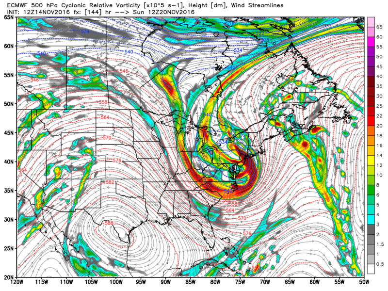
![]() by Frank_Wx Mon Nov 14, 2016 6:25 pm
by Frank_Wx Mon Nov 14, 2016 6:25 pm
Frank_Wx wrote:Must say, I am interesting in a possible wintry event for our area on or near Thanksgiving. I think the pattern by far favors N&W for this one due to the lack of cold air but those details are not important. We'll see how this looks as we get closer. Timing needs to be ironed out first with the wave of interesting ejecting east while cold is still over us.
I figured I won't leave you all hanging with this.
This weekend the upper Midwest is in line to get slammed by this seasons first major snowstorm. As the storms cuts off northwest of Chicago, that's going to allow winds to turn from the south and pump a ridge over our area. Temps may approach 70 degrees later this week and weekend.

As the storm jets into northeast Canada, a cold front sweeps across the Great Lakes and eventually our area bringing little rain. Behind this front will be our first blast of colder than normal air. The GFS is projecting high temps in the low to mid 40s and lows in the upper 20s.
1pm Monday temps

1pm Tuesday temps

What remains unknown is how long this blast of colder than normal weather will last. At the get together I mentioned there will be a 3-5 day period near Thanksgiving. Is it possible the cold lasts beyond 5 days? Yes. However, until we see consistency and get closer in time I'm only comfortable saying it will just be a few days, Reason is I'm not confident how strong or "stay-worthy" this -NAO showing on the models will be. My gut tells me it's a transient ridge since the Pacific continues to look unfavorable. So if we're to take advantage of a potential wintry event let's hope it happens between the 22nd and 27th.
_________________
_______________________________________________________________________________________________________
CLICK HERE to view NJ Strong Snowstorm Classifications
Frank_Wx- Godzilla Seeker
- Posts : 21305
Reputation : 328
Join date : 2013-01-05
Age : 31
Location : Jersey City, NJ -
Re: Long Range Thread 12.0
![]() by Frank_Wx Mon Nov 14, 2016 6:50 pm
by Frank_Wx Mon Nov 14, 2016 6:50 pm

_________________
_______________________________________________________________________________________________________
CLICK HERE to view NJ Strong Snowstorm Classifications
Frank_Wx- Godzilla Seeker
- Posts : 21305
Reputation : 328
Join date : 2013-01-05
Age : 31
Location : Jersey City, NJ -
Re: Long Range Thread 12.0
![]() by Frank_Wx Mon Nov 14, 2016 6:55 pm
by Frank_Wx Mon Nov 14, 2016 6:55 pm

_________________
_______________________________________________________________________________________________________
CLICK HERE to view NJ Strong Snowstorm Classifications
Frank_Wx- Godzilla Seeker
- Posts : 21305
Reputation : 328
Join date : 2013-01-05
Age : 31
Location : Jersey City, NJ -
Re: Long Range Thread 12.0
![]() by amugs Mon Nov 14, 2016 7:41 pm
by amugs Mon Nov 14, 2016 7:41 pm


See the black arrow that is hangover warm waters from NINO that are producing a roaring PAC JET atthis time and teh differnces in teh pressures above and below are enhancing this.
Classic +PDO setting up


_________________
Mugs
AKA:King: Snow Weenie
Self Proclaimed
WINTER 2014-15 : 55.12" +.02 for 6 coatings (avg. 35")
WINTER 2015-16 Total - 29.8" (Avg 35")
WINTER 2016-17 : 39.5" so far

amugs- Advanced Forecaster - Mod

- Posts : 15093
Reputation : 213
Join date : 2013-01-07
Age : 54
Location : Hillsdale,NJ
Re: Long Range Thread 12.0
![]() by Frank_Wx Mon Nov 14, 2016 8:23 pm
by Frank_Wx Mon Nov 14, 2016 8:23 pm
_________________
_______________________________________________________________________________________________________
CLICK HERE to view NJ Strong Snowstorm Classifications
Frank_Wx- Godzilla Seeker
- Posts : 21305
Reputation : 328
Join date : 2013-01-05
Age : 31
Location : Jersey City, NJ -
Re: Long Range Thread 12.0
![]() by amugs Mon Nov 14, 2016 8:33 pm
by amugs Mon Nov 14, 2016 8:33 pm
Good read and gives hope!
https://www.nymetroweather.com/2016/11/07/winterforecast1617/
_________________
Mugs
AKA:King: Snow Weenie
Self Proclaimed
WINTER 2014-15 : 55.12" +.02 for 6 coatings (avg. 35")
WINTER 2015-16 Total - 29.8" (Avg 35")
WINTER 2016-17 : 39.5" so far
amugs- Advanced Forecaster - Mod
- Posts : 15093
Reputation : 213
Join date : 2013-01-07
Age : 54
Location : Hillsdale,NJ
Re: Long Range Thread 12.0
![]() by Math23x7 Mon Nov 14, 2016 8:50 pm
by Math23x7 Mon Nov 14, 2016 8:50 pm
Math23x7- Wx Statistician Guru

- Posts : 2379
Reputation : 68
Join date : 2013-01-08
Re: Long Range Thread 12.0
![]() by amugs Mon Nov 14, 2016 8:55 pm
by amugs Mon Nov 14, 2016 8:55 pm
_________________
Mugs
AKA:King: Snow Weenie
Self Proclaimed
WINTER 2014-15 : 55.12" +.02 for 6 coatings (avg. 35")
WINTER 2015-16 Total - 29.8" (Avg 35")
WINTER 2016-17 : 39.5" so far
amugs- Advanced Forecaster - Mod
- Posts : 15093
Reputation : 213
Join date : 2013-01-07
Age : 54
Location : Hillsdale,NJ
Re: Long Range Thread 12.0
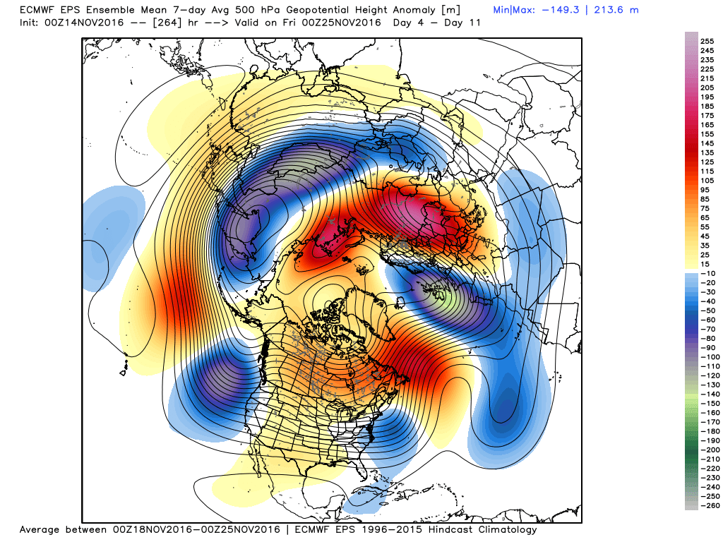
![]() by amugs Mon Nov 14, 2016 9:11 pm
by amugs Mon Nov 14, 2016 9:11 pm

Great Sign on this chart

_________________
Mugs
AKA:King: Snow Weenie
Self Proclaimed
WINTER 2014-15 : 55.12" +.02 for 6 coatings (avg. 35")
WINTER 2015-16 Total - 29.8" (Avg 35")
WINTER 2016-17 : 39.5" so far
amugs- Advanced Forecaster - Mod
- Posts : 15093
Reputation : 213
Join date : 2013-01-07
Age : 54
Location : Hillsdale,NJ
Re: Long Range Thread 12.0
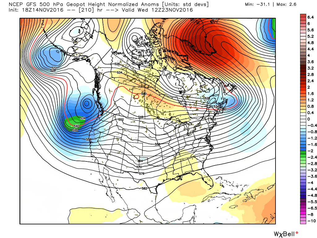
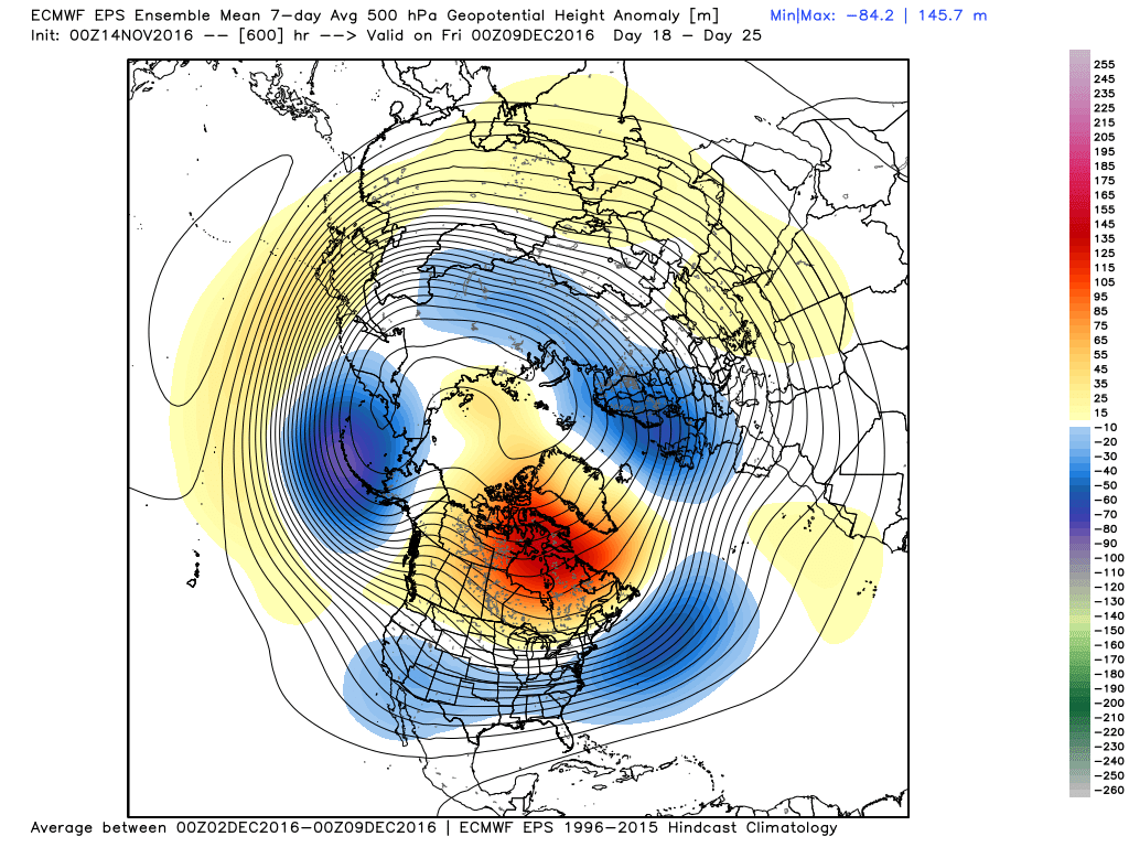
![]() by Frank_Wx Mon Nov 14, 2016 9:27 pm
by Frank_Wx Mon Nov 14, 2016 9:27 pm
Days 4-11
Days 7-11
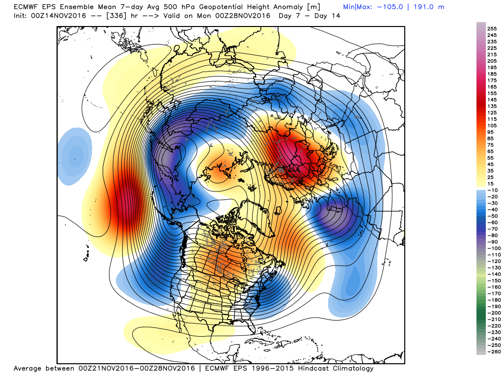
Day 11-18
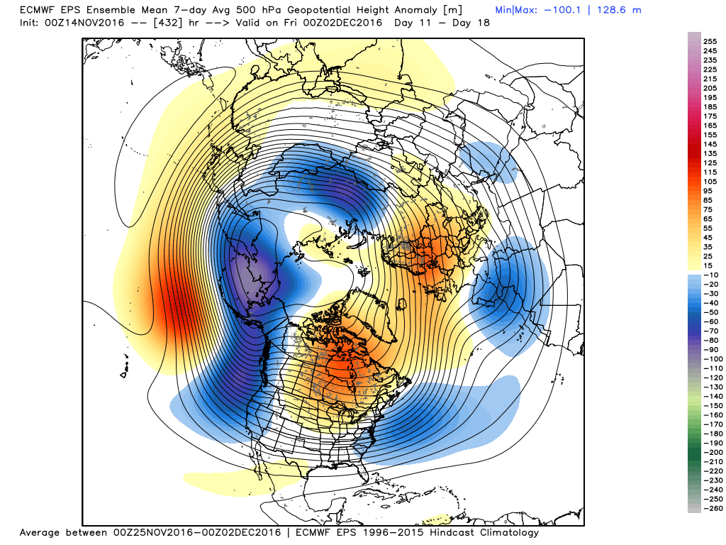
Day 18-25
_________________
_______________________________________________________________________________________________________
CLICK HERE to view NJ Strong Snowstorm Classifications
Frank_Wx- Godzilla Seeker
- Posts : 21305
Reputation : 328
Join date : 2013-01-05
Age : 31
Location : Jersey City, NJ -
Re: Long Range Thread 12.0
![]() by Frank_Wx Mon Nov 14, 2016 9:27 pm
by Frank_Wx Mon Nov 14, 2016 9:27 pm
_________________
_______________________________________________________________________________________________________
CLICK HERE to view NJ Strong Snowstorm Classifications
Frank_Wx- Godzilla Seeker
- Posts : 21305
Reputation : 328
Join date : 2013-01-05
Age : 31
Location : Jersey City, NJ -
Re: Long Range Thread 12.0
![]() by Dunnzoo Mon Nov 14, 2016 11:56 pm
by Dunnzoo Mon Nov 14, 2016 11:56 pm
_________________
Janet
Snowfall winter of 2023-2024 17.5"
Snowfall winter of 2022-2023 6.0"
Snowfall winter of 2021-2022 17.6" 1" sleet 2/25/22
Snowfall winter of 2020-2021 51.1"
Snowfall winter of 2019-2020 8.5"
Snowfall winter of 2018-2019 25.1"
Snowfall winter of 2017-2018 51.9"
Snowfall winter of 2016-2017 45.6"
Snowfall winter of 2015-2016 29.5"
Snowfall winter of 2014-2015 50.55"
Snowfall winter of 2013-2014 66.5"

Dunnzoo- Senior Enthusiast - Mod
- Posts : 4887
Reputation : 68
Join date : 2013-01-11
Age : 62
Location : Westwood, NJ
Re: Long Range Thread 12.0
![]() by algae888 Tue Nov 15, 2016 2:23 am
by algae888 Tue Nov 15, 2016 2:23 am
Dunnzoo wrote:Wow, looks like travel during Thanksgiving week is going to be rough....


algae888- Advanced Forecaster
- Posts : 5311
Reputation : 46
Join date : 2013-02-05
Age : 61
Location : mt. vernon, new york
Re: Long Range Thread 12.0
![]() by algae888 Tue Nov 15, 2016 4:25 am
by algae888 Tue Nov 15, 2016 4:25 am

there are times when a block sets up it's hard to break. really would be great to get winter off to an early start.
algae888- Advanced Forecaster
- Posts : 5311
Reputation : 46
Join date : 2013-02-05
Age : 61
Location : mt. vernon, new york
Page 19 of 40 • 1 ... 11 ... 18, 19, 20 ... 29 ... 40 ![]()
|
|
|