
 Search
2017 General Tropical Cyclone Discussion Thread
Page 34 of 40 •  1 ... 18 ... 33, 34, 35 ... 40
 ![]()
Re: 2017 General Tropical Cyclone Discussion Thread
![]() by Quietace Wed Aug 30, 2017 10:24 pm
by Quietace Wed Aug 30, 2017 10:24 pm
While SST have a direct correlation to TC intensity, a already intense cyclone in a favorable environment with other support factors can retain intensity with lower SST. Though, ~26.5*C isn't too cold. Another note is that a already intense TC that is re-curving with enough forward velocity will prevent up-welling, and also minimize time it has to weaken over the cooler SST before transitioning into a ex-trop cyclone, example: NE Hurricane 1938....EnyapWeather wrote:I thought with the temperature of the waters off the NJ coast it was nearly impossible to have a cat 3 or 4, dare if I say 5. Can someone correct me if I'm wrong? Also I can't imagine what it would look like if a cat 4 or even 5 blew through here? Would houses be torn apart?
Quietace- Meteorologist - Mod

- Posts : 3687
Join date : 2013-01-07
Re: 2017 General Tropical Cyclone Discussion Thread
![]() by Quietace Wed Aug 30, 2017 10:32 pm
by Quietace Wed Aug 30, 2017 10:32 pm

Quietace- Meteorologist - Mod
- Posts : 3687
Join date : 2013-01-07
Re: 2017 General Tropical Cyclone Discussion Thread
![]() by Quietace Wed Aug 30, 2017 10:39 pm
by Quietace Wed Aug 30, 2017 10:39 pm


Quietace- Meteorologist - Mod
- Posts : 3687
Reputation : 33
Join date : 2013-01-07
Age : 27
Location : Point Pleasant, NJ
Re: 2017 General Tropical Cyclone Discussion Thread
![]() by Guest Wed Aug 30, 2017 10:58 pm
by Guest Wed Aug 30, 2017 10:58 pm
RJB8525 wrote:pray, voodoo rituals whatever the hell you want to do in order to keep this damn system away from us
Sign me up right now for a cat 4 direct hit on LI. I'm in. And yes I know the damage that would occur. I just wanna live it. And before anyone complains we live on the coast. It's part of the gamble.
Guest- Guest
Re: 2017 General Tropical Cyclone Discussion Thread
![]() by jmanley32 Wed Aug 30, 2017 11:07 pm
by jmanley32 Wed Aug 30, 2017 11:07 pm

jmanley32- Senior Enthusiast

- Posts : 20517
Reputation : 108
Join date : 2013-12-12
Age : 42
Location : Yonkers, NY
Re: 2017 General Tropical Cyclone Discussion Thread
![]() by Grselig Wed Aug 30, 2017 11:45 pm
by Grselig Wed Aug 30, 2017 11:45 pm

Grselig- Senior Enthusiast
- Posts : 1408
Reputation : 140
Join date : 2013-03-04
Age : 54
Location : Wayne NJ
Re: 2017 General Tropical Cyclone Discussion Thread
![]() by mwilli5783 Thu Aug 31, 2017 12:25 am
by mwilli5783 Thu Aug 31, 2017 12:25 am
mwilli5783- Posts : 146
Reputation : 9
Join date : 2013-01-23
Age : 69
Location : hempstead n.y
Re: 2017 General Tropical Cyclone Discussion Thread
![]() by jmanley32 Thu Aug 31, 2017 5:48 am
by jmanley32 Thu Aug 31, 2017 5:48 am
jmanley32- Senior Enthusiast
- Posts : 20517
Reputation : 108
Join date : 2013-12-12
Age : 42
Location : Yonkers, NY
Re: 2017 General Tropical Cyclone Discussion Thread
![]() by jmanley32 Thu Aug 31, 2017 6:35 am
by jmanley32 Thu Aug 31, 2017 6:35 am
jmanley32- Senior Enthusiast
- Posts : 20517
Reputation : 108
Join date : 2013-12-12
Age : 42
Location : Yonkers, NY
Re: 2017 General Tropical Cyclone Discussion Thread
![]() by nutleyblizzard Thu Aug 31, 2017 6:41 am
by nutleyblizzard Thu Aug 31, 2017 6:41 am
Yea Jman I'm watching the GFS run too. You can clearly see the trough is going to pick up Irma and pull it right up the coast. That was my concern that I mentioned yesterday. Devastating run incoming.jmanley32 wrote:Hmm gfs is west and east coast bound euro operational stays well south while the ensembles are more in line with gfs. Scary 06z run incoming think we see a direct cat 5 landfall from obx or North...

nutleyblizzard- Senior Enthusiast
- Posts : 1952
Reputation : 41
Join date : 2014-01-30
Age : 58
Location : Nutley, new jersey
Re: 2017 General Tropical Cyclone Discussion Thread
![]() by jmanley32 Thu Aug 31, 2017 6:42 am
by jmanley32 Thu Aug 31, 2017 6:42 am
jmanley32- Senior Enthusiast
- Posts : 20517
Reputation : 108
Join date : 2013-12-12
Age : 42
Location : Yonkers, NY
Re: 2017 General Tropical Cyclone Discussion Thread
![]() by jmanley32 Thu Aug 31, 2017 6:44 am
by jmanley32 Thu Aug 31, 2017 6:44 am
jmanley32- Senior Enthusiast
- Posts : 20517
Reputation : 108
Join date : 2013-12-12
Age : 42
Location : Yonkers, NY
Re: 2017 General Tropical Cyclone Discussion Thread
![]() by skinsfan1177 Thu Aug 31, 2017 6:46 am
by skinsfan1177 Thu Aug 31, 2017 6:46 am

skinsfan1177- Senior Enthusiast
- Posts : 4485
Reputation : 35
Join date : 2013-01-07
Age : 46
Location : Point Pleasant Boro
Re: 2017 General Tropical Cyclone Discussion Thread
![]() by jmanley32 Thu Aug 31, 2017 6:49 am
by jmanley32 Thu Aug 31, 2017 6:49 am
jmanley32- Senior Enthusiast
- Posts : 20517
Reputation : 108
Join date : 2013-12-12
Age : 42
Location : Yonkers, NY
Re: 2017 General Tropical Cyclone Discussion Thread
![]() by jmanley32 Thu Aug 31, 2017 6:50 am
by jmanley32 Thu Aug 31, 2017 6:50 am
jmanley32- Senior Enthusiast
- Posts : 20517
Reputation : 108
Join date : 2013-12-12
Age : 42
Location : Yonkers, NY
Re: 2017 General Tropical Cyclone Discussion Thread
![]() by jmanley32 Thu Aug 31, 2017 6:58 am
by jmanley32 Thu Aug 31, 2017 6:58 am
jmanley32- Senior Enthusiast
- Posts : 20517
Reputation : 108
Join date : 2013-12-12
Age : 42
Location : Yonkers, NY
Re: 2017 General Tropical Cyclone Discussion Thread
![]() by Dunnzoo Thu Aug 31, 2017 7:10 am
by Dunnzoo Thu Aug 31, 2017 7:10 am
jmanley32 wrote:People on other boards are say it's trending to the euro in staying more west. I don't think at this juncture can call anything a trend.
At this point can't call anything...too far out and too many variables. Wait til next week, no need to get excited about it now and hyping up a storm that may just be one for the fishes
_________________
Janet
Snowfall winter of 2023-2024 17.5"
Snowfall winter of 2022-2023 6.0"
Snowfall winter of 2021-2022 17.6" 1" sleet 2/25/22
Snowfall winter of 2020-2021 51.1"
Snowfall winter of 2019-2020 8.5"
Snowfall winter of 2018-2019 25.1"
Snowfall winter of 2017-2018 51.9"
Snowfall winter of 2016-2017 45.6"
Snowfall winter of 2015-2016 29.5"
Snowfall winter of 2014-2015 50.55"
Snowfall winter of 2013-2014 66.5"

Dunnzoo- Senior Enthusiast - Mod

- Posts : 4892
Reputation : 68
Join date : 2013-01-11
Age : 62
Location : Westwood, NJ
Re: 2017 General Tropical Cyclone Discussion Thread
![]() by sroc4 Thu Aug 31, 2017 7:51 am
by sroc4 Thu Aug 31, 2017 7:51 am
EURO:

GFS:

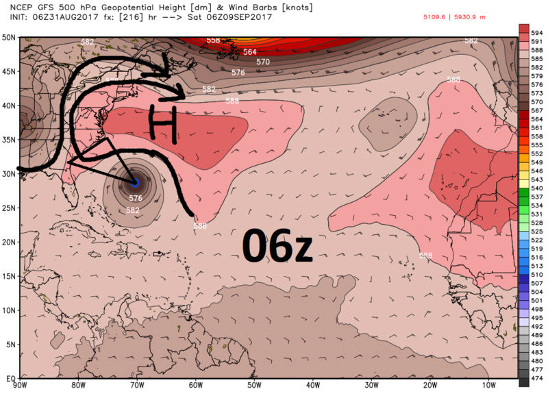
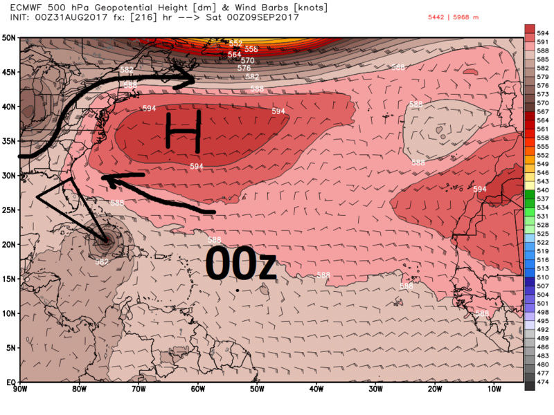
Here are the Euro Ensembles followed by the GFS ensembles. As you will see below both have a wide spread extending from GOM to NE with euro mean currently centered near the GOM or Fla Straits and GFS 1 clustering off the SE coast, and another E of OBX:
EPS:
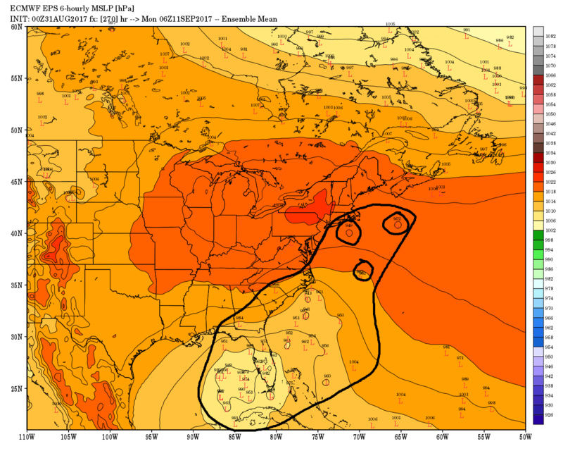
GEFS:
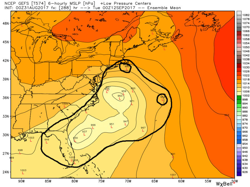
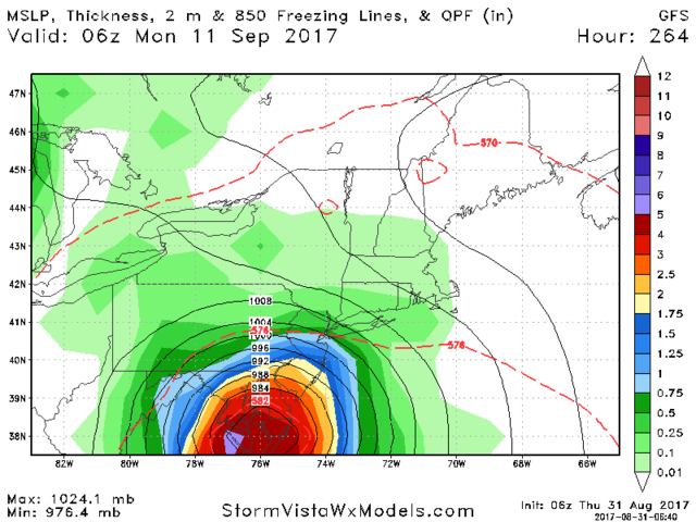
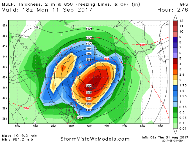
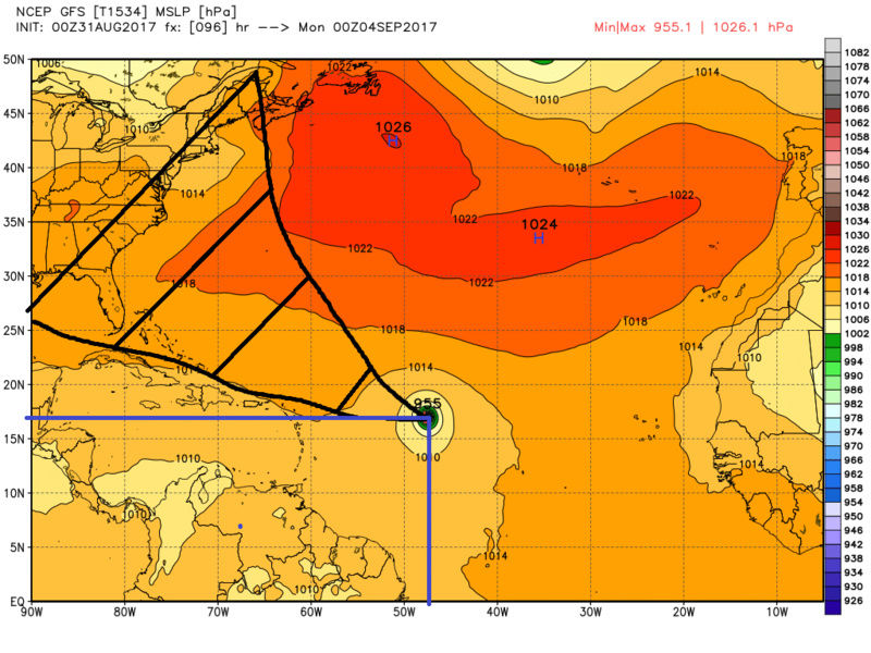
As you can see highly volatile run to run within models at 500mb. Below is where the Euro Op and GFS Op have the MSLP center of Irma located at day 4. Even though both models have the MSLP center close to each other by day 4 you can still see there are differences. From there Euro makes landfall over the northern Lesser Antilles between day 6-7; whereas, the GFS takes Irma well north of the islands between day 6-7. As you can plainly see beyond day four the cone of uncertainty extends from the GOM to Nova Scotia Canada. So again zero consistent trending is seen beyond day 4 at this time.


_________________
"In weather and in life, there's no winning and losing; there's only winning and learning."
WINTER 2012/2013 TOTALS 43.65"WINTER 2017/2018 TOTALS 62.85" WINTER 2022/2023 TOTALS 4.9"
WINTER 2013/2014 TOTALS 64.85"WINTER 2018/2019 TOTALS 14.25" WINTER 2023/2024 TOTALS 13.1"
WINTER 2014/2015 TOTALS 71.20"WINTER 2019/2020 TOTALS 6.35"
WINTER 2015/2016 TOTALS 35.00"WINTER 2020/2021 TOTALS 37.75"
WINTER 2016/2017 TOTALS 42.25"WINTER 2021/2022 TOTALS 31.65"

sroc4- Admin

- Posts : 8331
Reputation : 301
Join date : 2013-01-07
Location : Wading River, LI
Re: 2017 General Tropical Cyclone Discussion Thread
![]() by Snow88 Thu Aug 31, 2017 9:15 am
by Snow88 Thu Aug 31, 2017 9:15 am

Snow88- Senior Enthusiast
- Posts : 2193
Reputation : 4
Join date : 2013-01-09
Age : 35
Location : Brooklyn, NY
Re: 2017 General Tropical Cyclone Discussion Thread
![]() by sroc4 Thu Aug 31, 2017 9:19 am
by sroc4 Thu Aug 31, 2017 9:19 am
_________________
"In weather and in life, there's no winning and losing; there's only winning and learning."
WINTER 2012/2013 TOTALS 43.65"WINTER 2017/2018 TOTALS 62.85" WINTER 2022/2023 TOTALS 4.9"
WINTER 2013/2014 TOTALS 64.85"WINTER 2018/2019 TOTALS 14.25" WINTER 2023/2024 TOTALS 13.1"
WINTER 2014/2015 TOTALS 71.20"WINTER 2019/2020 TOTALS 6.35"
WINTER 2015/2016 TOTALS 35.00"WINTER 2020/2021 TOTALS 37.75"
WINTER 2016/2017 TOTALS 42.25"WINTER 2021/2022 TOTALS 31.65"
sroc4- Admin
- Posts : 8331
Reputation : 301
Join date : 2013-01-07
Location : Wading River, LI
Re: 2017 General Tropical Cyclone Discussion Thread
![]() by Frank_Wx Thu Aug 31, 2017 9:29 am
by Frank_Wx Thu Aug 31, 2017 9:29 am


_________________
_______________________________________________________________________________________________________
CLICK HERE to view NJ Strong Snowstorm Classifications

Frank_Wx- Godzilla Seeker
- Posts : 21305
Reputation : 328
Join date : 2013-01-05
Age : 31
Location : Jersey City, NJ -

Re: 2017 General Tropical Cyclone Discussion Thread
![]() by jmanley32 Thu Aug 31, 2017 9:30 am
by jmanley32 Thu Aug 31, 2017 9:30 am
jmanley32- Senior Enthusiast
- Posts : 20517
Reputation : 108
Join date : 2013-12-12
Age : 42
Location : Yonkers, NY
Re: 2017 General Tropical Cyclone Discussion Thread
![]() by sroc4 Thu Aug 31, 2017 9:42 am
by sroc4 Thu Aug 31, 2017 9:42 am
_________________
"In weather and in life, there's no winning and losing; there's only winning and learning."
WINTER 2012/2013 TOTALS 43.65"WINTER 2017/2018 TOTALS 62.85" WINTER 2022/2023 TOTALS 4.9"
WINTER 2013/2014 TOTALS 64.85"WINTER 2018/2019 TOTALS 14.25" WINTER 2023/2024 TOTALS 13.1"
WINTER 2014/2015 TOTALS 71.20"WINTER 2019/2020 TOTALS 6.35"
WINTER 2015/2016 TOTALS 35.00"WINTER 2020/2021 TOTALS 37.75"
WINTER 2016/2017 TOTALS 42.25"WINTER 2021/2022 TOTALS 31.65"
sroc4- Admin
- Posts : 8331
Reputation : 301
Join date : 2013-01-07
Location : Wading River, LI
Re: 2017 General Tropical Cyclone Discussion Thread
![]() by weatherwatchermom Thu Aug 31, 2017 9:57 am
by weatherwatchermom Thu Aug 31, 2017 9:57 am
Frank_Wx wrote:What's slightly concerning for the East Coast in regards to Irma is the mid-level trough models show swinging through the Great Lakes September 5th-6th. Unfortunately we're all pretty aware what happens when timing between a trough and an Atlantic Hurricane comes together just right. Further, and I'm not sure what other models besides the GFS show this, there is another tropical entity shown to form in the Gulf of Mexico in that 5th-6th time frame which may try to enhance that mid-level trough as it comes through the East Coast. Probably the main player in the set-up is the High Pressure acting as a block possibly preventing the storm from heading out to sea. It has a decent path to move pretty far west. How far west depends on the aforementioned mid-level trough. I won't comment much at this point since I have not had a chance to review other guidance, but Irma needs to be watched for sure.
thanks frank.this is all a little concerning..is mid week next week the point when when we will have a better idea? .on a happier note .glad to see you are back..hope you enjoyed your summer...nice picture!!

weatherwatchermom- Senior Enthusiast
- Posts : 3750
Reputation : 77
Join date : 2014-11-25
Age : 60
Location : Hazlet Township, NJ
Re: 2017 General Tropical Cyclone Discussion Thread
![]() by Frank_Wx Thu Aug 31, 2017 10:02 am
by Frank_Wx Thu Aug 31, 2017 10:02 am
.thumb.png.dc644c7b009c36cf3ab311e44fa5c5da.png)
_________________
_______________________________________________________________________________________________________
CLICK HERE to view NJ Strong Snowstorm Classifications
Frank_Wx- Godzilla Seeker
- Posts : 21305
Reputation : 328
Join date : 2013-01-05
Age : 31
Location : Jersey City, NJ -
Re: 2017 General Tropical Cyclone Discussion Thread
![]() by Frank_Wx Thu Aug 31, 2017 10:04 am
by Frank_Wx Thu Aug 31, 2017 10:04 am
weatherwatchermom wrote:Frank_Wx wrote:What's slightly concerning for the East Coast in regards to Irma is the mid-level trough models show swinging through the Great Lakes September 5th-6th. Unfortunately we're all pretty aware what happens when timing between a trough and an Atlantic Hurricane comes together just right. Further, and I'm not sure what other models besides the GFS show this, there is another tropical entity shown to form in the Gulf of Mexico in that 5th-6th time frame which may try to enhance that mid-level trough as it comes through the East Coast. Probably the main player in the set-up is the High Pressure acting as a block possibly preventing the storm from heading out to sea. It has a decent path to move pretty far west. How far west depends on the aforementioned mid-level trough. I won't comment much at this point since I have not had a chance to review other guidance, but Irma needs to be watched for sure.
thanks frank.this is all a little concerning..is mid week next week the point when when we will have a better idea? .on a happier note .glad to see you are back..hope you enjoyed your summer...nice picture!!
I would say Labor Day we have a decent idea whether she goes out to sea or makes landfall somewhere along the East Coast of the U.S.
_________________
_______________________________________________________________________________________________________
CLICK HERE to view NJ Strong Snowstorm Classifications
Frank_Wx- Godzilla Seeker
- Posts : 21305
Reputation : 328
Join date : 2013-01-05
Age : 31
Location : Jersey City, NJ -
Re: 2017 General Tropical Cyclone Discussion Thread
![]() by Frank_Wx Thu Aug 31, 2017 10:33 am
by Frank_Wx Thu Aug 31, 2017 10:33 am

_________________
_______________________________________________________________________________________________________
CLICK HERE to view NJ Strong Snowstorm Classifications
Frank_Wx- Godzilla Seeker
- Posts : 21305
Reputation : 328
Join date : 2013-01-05
Age : 31
Location : Jersey City, NJ -
Page 34 of 40 • 1 ... 18 ... 33, 34, 35 ... 40 ![]()
|
|
|