
 Search
2017 General Tropical Cyclone Discussion Thread
Page 35 of 40 •  1 ... 19 ... 34, 35, 36 ... 40
 ![]()
Re: 2017 General Tropical Cyclone Discussion Thread
![]() by Frank_Wx Thu Aug 31, 2017 10:04 am
by Frank_Wx Thu Aug 31, 2017 10:04 am
weatherwatchermom wrote:Frank_Wx wrote:What's slightly concerning for the East Coast in regards to Irma is the mid-level trough models show swinging through the Great Lakes September 5th-6th. Unfortunately we're all pretty aware what happens when timing between a trough and an Atlantic Hurricane comes together just right. Further, and I'm not sure what other models besides the GFS show this, there is another tropical entity shown to form in the Gulf of Mexico in that 5th-6th time frame which may try to enhance that mid-level trough as it comes through the East Coast. Probably the main player in the set-up is the High Pressure acting as a block possibly preventing the storm from heading out to sea. It has a decent path to move pretty far west. How far west depends on the aforementioned mid-level trough. I won't comment much at this point since I have not had a chance to review other guidance, but Irma needs to be watched for sure.
thanks frank.this is all a little concerning..is mid week next week the point when when we will have a better idea? .on a happier note .glad to see you are back..hope you enjoyed your summer...nice picture!!


I would say Labor Day we have a decent idea whether she goes out to sea or makes landfall somewhere along the East Coast of the U.S.
Frank_Wx- Godzilla Seeker

- Posts : 21305
Join date : 2013-01-05 -

Re: 2017 General Tropical Cyclone Discussion Thread
![]() by Frank_Wx Thu Aug 31, 2017 10:33 am
by Frank_Wx Thu Aug 31, 2017 10:33 am

Frank_Wx- Godzilla Seeker
- Posts : 21305
Join date : 2013-01-05 -
Re: 2017 General Tropical Cyclone Discussion Thread
![]() by sroc4 Thu Aug 31, 2017 10:37 am
by sroc4 Thu Aug 31, 2017 10:37 am
_________________
"In weather and in life, there's no winning and losing; there's only winning and learning."
WINTER 2012/2013 TOTALS 43.65"WINTER 2017/2018 TOTALS 62.85" WINTER 2022/2023 TOTALS 4.9"
WINTER 2013/2014 TOTALS 64.85"WINTER 2018/2019 TOTALS 14.25" WINTER 2023/2024 TOTALS 13.1"
WINTER 2014/2015 TOTALS 71.20"WINTER 2019/2020 TOTALS 6.35"
WINTER 2015/2016 TOTALS 35.00"WINTER 2020/2021 TOTALS 37.75"
WINTER 2016/2017 TOTALS 42.25"WINTER 2021/2022 TOTALS 31.65"

sroc4- Admin
- Posts : 8331
Reputation : 301
Join date : 2013-01-07
Location : Wading River, LI
Re: 2017 General Tropical Cyclone Discussion Thread
![]() by sroc4 Thu Aug 31, 2017 10:43 am
by sroc4 Thu Aug 31, 2017 10:43 am
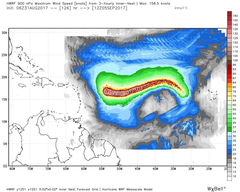
sroc4 wrote:Check out the eye wall structure already. Irma is going to be a beautiful system at her peek which will likely be a Cat 5 at some point.
She is a beauty alright. It is already a hurricane at 75kt winds. Mark my words expect it to be a Cat 2 before days end.
_________________
"In weather and in life, there's no winning and losing; there's only winning and learning."
WINTER 2012/2013 TOTALS 43.65"WINTER 2017/2018 TOTALS 62.85" WINTER 2022/2023 TOTALS 4.9"
WINTER 2013/2014 TOTALS 64.85"WINTER 2018/2019 TOTALS 14.25" WINTER 2023/2024 TOTALS 13.1"
WINTER 2014/2015 TOTALS 71.20"WINTER 2019/2020 TOTALS 6.35"
WINTER 2015/2016 TOTALS 35.00"WINTER 2020/2021 TOTALS 37.75"
WINTER 2016/2017 TOTALS 42.25"WINTER 2021/2022 TOTALS 31.65"
sroc4- Admin
- Posts : 8331
Reputation : 301
Join date : 2013-01-07
Location : Wading River, LI
Re: 2017 General Tropical Cyclone Discussion Thread
![]() by hyde345 Thu Aug 31, 2017 10:56 am
by hyde345 Thu Aug 31, 2017 10:56 am

hyde345- Pro Enthusiast

- Posts : 1082
Reputation : 48
Join date : 2013-01-08
Location : Hyde Park, NY
Re: 2017 General Tropical Cyclone Discussion Thread
![]() by sroc4 Thu Aug 31, 2017 11:10 am
by sroc4 Thu Aug 31, 2017 11:10 am
hyde345 wrote:Irma already Cat 2 with 100 MPH winds and 979MB. Wow.

_________________
"In weather and in life, there's no winning and losing; there's only winning and learning."
WINTER 2012/2013 TOTALS 43.65"WINTER 2017/2018 TOTALS 62.85" WINTER 2022/2023 TOTALS 4.9"
WINTER 2013/2014 TOTALS 64.85"WINTER 2018/2019 TOTALS 14.25" WINTER 2023/2024 TOTALS 13.1"
WINTER 2014/2015 TOTALS 71.20"WINTER 2019/2020 TOTALS 6.35"
WINTER 2015/2016 TOTALS 35.00"WINTER 2020/2021 TOTALS 37.75"
WINTER 2016/2017 TOTALS 42.25"WINTER 2021/2022 TOTALS 31.65"
sroc4- Admin
- Posts : 8331
Reputation : 301
Join date : 2013-01-07
Location : Wading River, LI
Re: 2017 General Tropical Cyclone Discussion Thread
![]() by Frank_Wx Thu Aug 31, 2017 11:38 am
by Frank_Wx Thu Aug 31, 2017 11:38 am
_________________
_______________________________________________________________________________________________________
CLICK HERE to view NJ Strong Snowstorm Classifications

Frank_Wx- Godzilla Seeker
- Posts : 21305
Reputation : 328
Join date : 2013-01-05
Age : 31
Location : Jersey City, NJ -
Re: 2017 General Tropical Cyclone Discussion Thread
![]() by rb924119 Thu Aug 31, 2017 11:38 am
by rb924119 Thu Aug 31, 2017 11:38 am
With the few minutes I looked this morning before work, I think I might have an opinion on the eventual track, and it may excite some of you DUH DUH DUH DUHHHHHHHHHHHHHH
rb924119- Meteorologist

- Posts : 6889
Reputation : 194
Join date : 2013-02-06
Age : 32
Location : Greentown, Pa
Re: 2017 General Tropical Cyclone Discussion Thread
![]() by jmanley32 Thu Aug 31, 2017 11:39 am
by jmanley32 Thu Aug 31, 2017 11:39 am

jmanley32- Senior Enthusiast

- Posts : 20513
Reputation : 108
Join date : 2013-12-12
Age : 42
Location : Yonkers, NY
Re: 2017 General Tropical Cyclone Discussion Thread
![]() by jmanley32 Thu Aug 31, 2017 11:41 am
by jmanley32 Thu Aug 31, 2017 11:41 am
hey Frank good to see ya hope it's was good. Got concerned where u were. Holy hell is right. Not go ask if it's go hit us cuz I know u will slap me lol but I see ur scroll is enough to let me know ur concerned.Frank_Wx wrote:Holy hell
jmanley32- Senior Enthusiast
- Posts : 20513
Reputation : 108
Join date : 2013-12-12
Age : 42
Location : Yonkers, NY
Re: 2017 General Tropical Cyclone Discussion Thread
![]() by jmanley32 Thu Aug 31, 2017 11:43 am
by jmanley32 Thu Aug 31, 2017 11:43 am
stop thinking and post my man! Something tells me this the real deal. And landfall or not it's go b a amazing storm to see at cat 5!rb924119 wrote:So I've been thinking............
With the few minutes I looked this morning before work, I think I might have an opinion on the eventual track, and it may excite some of you DUH DUH DUH DUHHHHHHHHHHHHHH
jmanley32- Senior Enthusiast
- Posts : 20513
Reputation : 108
Join date : 2013-12-12
Age : 42
Location : Yonkers, NY
Re: 2017 General Tropical Cyclone Discussion Thread
![]() by SoulSingMG Thu Aug 31, 2017 11:46 am
by SoulSingMG Thu Aug 31, 2017 11:46 am

SoulSingMG- Senior Enthusiast
- Posts : 2853
Reputation : 74
Join date : 2013-12-11
Location : Long Island City, NY
Re: 2017 General Tropical Cyclone Discussion Thread
![]() by Frank_Wx Thu Aug 31, 2017 11:53 am
by Frank_Wx Thu Aug 31, 2017 11:53 am
Hurricane Hugo
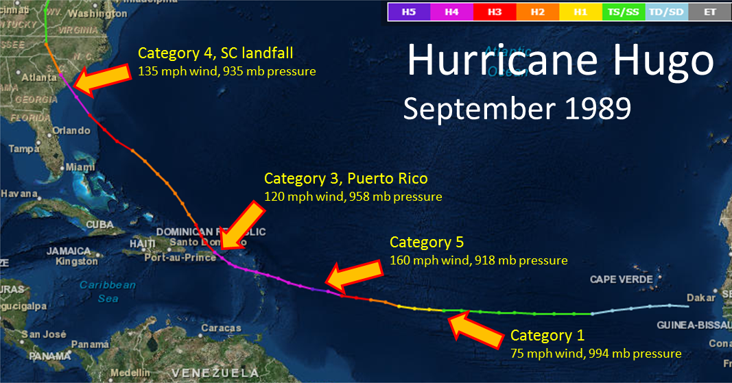
And Hurricane Isabel
_________________
_______________________________________________________________________________________________________
CLICK HERE to view NJ Strong Snowstorm Classifications
Frank_Wx- Godzilla Seeker
- Posts : 21305
Reputation : 328
Join date : 2013-01-05
Age : 31
Location : Jersey City, NJ -
Re: 2017 General Tropical Cyclone Discussion Thread
![]() by Frank_Wx Thu Aug 31, 2017 11:56 am
by Frank_Wx Thu Aug 31, 2017 11:56 am

_________________
_______________________________________________________________________________________________________
CLICK HERE to view NJ Strong Snowstorm Classifications
Frank_Wx- Godzilla Seeker
- Posts : 21305
Reputation : 328
Join date : 2013-01-05
Age : 31
Location : Jersey City, NJ -
Re: 2017 General Tropical Cyclone Discussion Thread
![]() by jmanley32 Thu Aug 31, 2017 11:56 am
by jmanley32 Thu Aug 31, 2017 11:56 am
jmanley32- Senior Enthusiast
- Posts : 20513
Reputation : 108
Join date : 2013-12-12
Age : 42
Location : Yonkers, NY
Re: 2017 General Tropical Cyclone Discussion Thread
![]() by Frank_Wx Thu Aug 31, 2017 11:58 am
by Frank_Wx Thu Aug 31, 2017 11:58 am
_________________
_______________________________________________________________________________________________________
CLICK HERE to view NJ Strong Snowstorm Classifications
Frank_Wx- Godzilla Seeker
- Posts : 21305
Reputation : 328
Join date : 2013-01-05
Age : 31
Location : Jersey City, NJ -
Re: 2017 General Tropical Cyclone Discussion Thread
![]() by jmanley32 Thu Aug 31, 2017 12:28 pm
by jmanley32 Thu Aug 31, 2017 12:28 pm
in what respect looks to be taking same track looks like it'll be close if not a landfall.Frank_Wx wrote:The 12z GFS is running now and there are already major changes at the 500mb level. Not surprising.
jmanley32- Senior Enthusiast
- Posts : 20513
Reputation : 108
Join date : 2013-12-12
Age : 42
Location : Yonkers, NY
Re: 2017 General Tropical Cyclone Discussion Thread
![]() by sroc4 Thu Aug 31, 2017 12:29 pm
by sroc4 Thu Aug 31, 2017 12:29 pm
jmanley32 wrote:in what respect looks to be taking same track looks like it'll be close if not a landfall.Frank_Wx wrote:The 12z GFS is running now and there are already major changes at the 500mb level. Not surprising.
Much less altlantic Ridging off the SE coast by hr 180 and sharper trough....unless trough splits or lifts out this will likely recurve OTS or at least East of past two runs
_________________
"In weather and in life, there's no winning and losing; there's only winning and learning."
WINTER 2012/2013 TOTALS 43.65"WINTER 2017/2018 TOTALS 62.85" WINTER 2022/2023 TOTALS 4.9"
WINTER 2013/2014 TOTALS 64.85"WINTER 2018/2019 TOTALS 14.25" WINTER 2023/2024 TOTALS 13.1"
WINTER 2014/2015 TOTALS 71.20"WINTER 2019/2020 TOTALS 6.35"
WINTER 2015/2016 TOTALS 35.00"WINTER 2020/2021 TOTALS 37.75"
WINTER 2016/2017 TOTALS 42.25"WINTER 2021/2022 TOTALS 31.65"
sroc4- Admin
- Posts : 8331
Reputation : 301
Join date : 2013-01-07
Location : Wading River, LI
Re: 2017 General Tropical Cyclone Discussion Thread
![]() by jmanley32 Thu Aug 31, 2017 12:39 pm
by jmanley32 Thu Aug 31, 2017 12:39 pm
jmanley32- Senior Enthusiast
- Posts : 20513
Reputation : 108
Join date : 2013-12-12
Age : 42
Location : Yonkers, NY
Re: 2017 General Tropical Cyclone Discussion Thread
![]() by jmanley32 Thu Aug 31, 2017 12:40 pm
by jmanley32 Thu Aug 31, 2017 12:40 pm
jmanley32- Senior Enthusiast
- Posts : 20513
Reputation : 108
Join date : 2013-12-12
Age : 42
Location : Yonkers, NY
Re: 2017 General Tropical Cyclone Discussion Thread
![]() by sroc4 Thu Aug 31, 2017 12:43 pm
by sroc4 Thu Aug 31, 2017 12:43 pm


looks like 12 z trys a trough split but too late. Trough centered over Tenn valley on 6 Z is centered over S NE on 12z. Looks like a near miss For LI/CapCod but only out to 235.
Point being...flip flop cont at H5. Take nothing serious yet.
_________________
"In weather and in life, there's no winning and losing; there's only winning and learning."
WINTER 2012/2013 TOTALS 43.65"WINTER 2017/2018 TOTALS 62.85" WINTER 2022/2023 TOTALS 4.9"
WINTER 2013/2014 TOTALS 64.85"WINTER 2018/2019 TOTALS 14.25" WINTER 2023/2024 TOTALS 13.1"
WINTER 2014/2015 TOTALS 71.20"WINTER 2019/2020 TOTALS 6.35"
WINTER 2015/2016 TOTALS 35.00"WINTER 2020/2021 TOTALS 37.75"
WINTER 2016/2017 TOTALS 42.25"WINTER 2021/2022 TOTALS 31.65"
sroc4- Admin
- Posts : 8331
Reputation : 301
Join date : 2013-01-07
Location : Wading River, LI
Re: 2017 General Tropical Cyclone Discussion Thread
![]() by jmanley32 Thu Aug 31, 2017 12:44 pm
by jmanley32 Thu Aug 31, 2017 12:44 pm
jmanley32- Senior Enthusiast
- Posts : 20513
Reputation : 108
Join date : 2013-12-12
Age : 42
Location : Yonkers, NY
Re: 2017 General Tropical Cyclone Discussion Thread
![]() by SoulSingMG Thu Aug 31, 2017 12:48 pm
by SoulSingMG Thu Aug 31, 2017 12:48 pm

SoulSingMG- Senior Enthusiast
- Posts : 2853
Reputation : 74
Join date : 2013-12-11
Location : Long Island City, NY
Re: 2017 General Tropical Cyclone Discussion Thread
![]() by jmanley32 Thu Aug 31, 2017 12:49 pm
by jmanley32 Thu Aug 31, 2017 12:49 pm
jmanley32- Senior Enthusiast
- Posts : 20513
Reputation : 108
Join date : 2013-12-12
Age : 42
Location : Yonkers, NY
Re: 2017 General Tropical Cyclone Discussion Thread
![]() by jmanley32 Thu Aug 31, 2017 12:51 pm
by jmanley32 Thu Aug 31, 2017 12:51 pm
and that's after truncation pressure is prolly far lower. If that's even imaginable. This at least is moving up in time and not back. I'm hoping max we track this is a week to 2 at most. Tropics too long lol. Good good and that one behind it follows similar path in lala land. Can only do one at a time lolSoulSingMG wrote:Man, what a BEAST. (Day 10)
jmanley32- Senior Enthusiast
- Posts : 20513
Reputation : 108
Join date : 2013-12-12
Age : 42
Location : Yonkers, NY
Re: 2017 General Tropical Cyclone Discussion Thread
![]() by jmanley32 Thu Aug 31, 2017 12:55 pm
by jmanley32 Thu Aug 31, 2017 12:55 pm
jmanley32- Senior Enthusiast
- Posts : 20513
Reputation : 108
Join date : 2013-12-12
Age : 42
Location : Yonkers, NY
Re: 2017 General Tropical Cyclone Discussion Thread
![]() by SoulSingMG Thu Aug 31, 2017 12:55 pm
by SoulSingMG Thu Aug 31, 2017 12:55 pm
jmanley32 wrote:and that's after truncation pressure is prolly far lower. If that's even imaginable. This at least is moving up in time and not back. I'm hoping max we track this is a week to 2 at most. Tropics too long lol. Good good and that one behind it follows similar path in lala land. Can only do one at a time lolSoulSingMG wrote:Man, what a BEAST. (Day 10)
I hear ya, Jman. It's daunting to know only a week from now can we actually start to take her track seriously. But hey, the joys of being crazy about meteorology.
SoulSingMG- Senior Enthusiast
- Posts : 2853
Reputation : 74
Join date : 2013-12-11
Location : Long Island City, NY
Page 35 of 40 • 1 ... 19 ... 34, 35, 36 ... 40 ![]()
|
|
|