
 Search
Tracking Hurricane Irma: Part 2
Page 10 of 21 •  1 ... 6 ... 9, 10, 11 ... 15 ... 21
 ![]()
Frank_Wx- Godzilla Seeker

- Posts : 21305
Join date : 2013-01-05 -

Re: Tracking Hurricane Irma: Part 2
![]() by gigs68 Thu Sep 07, 2017 3:52 pm
by gigs68 Thu Sep 07, 2017 3:52 pm
My Aunt and Cousins live in Coral Gables. Their planning on staying. What's your thought?
gigs68- Posts : 142
Join date : 2013-01-16
Re: Tracking Hurricane Irma: Part 2
![]() by Math23x7 Thu Sep 07, 2017 4:04 pm
by Math23x7 Thu Sep 07, 2017 4:04 pm
No water food or gas to buy...hunkering down and business is very slow
Math23x7- Wx Statistician Guru

- Posts : 2379
Reputation : 68
Join date : 2013-01-08
Re: Tracking Hurricane Irma: Part 2
![]() by rb924119 Thu Sep 07, 2017 4:21 pm
by rb924119 Thu Sep 07, 2017 4:21 pm
rb924119- Meteorologist

- Posts : 6890
Reputation : 194
Join date : 2013-02-06
Age : 32
Location : Greentown, Pa
Re: Tracking Hurricane Irma: Part 2
![]() by aiannone Thu Sep 07, 2017 4:33 pm
by aiannone Thu Sep 07, 2017 4:33 pm

_________________
-Alex Iannone-

aiannone- Senior Enthusiast - Mod

- Posts : 4813
Reputation : 92
Join date : 2013-01-07
Location : Saint James, LI (Northwest Suffolk Co.)
Re: Tracking Hurricane Irma: Part 2
![]() by aiannone Thu Sep 07, 2017 4:46 pm
by aiannone Thu Sep 07, 2017 4:46 pm
_________________
-Alex Iannone-
aiannone- Senior Enthusiast - Mod
- Posts : 4813
Reputation : 92
Join date : 2013-01-07
Location : Saint James, LI (Northwest Suffolk Co.)
Re: Tracking Hurricane Irma: Part 2
![]() by Disneyprincess1592 Thu Sep 07, 2017 5:39 pm
by Disneyprincess1592 Thu Sep 07, 2017 5:39 pm
Disneyprincess1592- Posts : 34
Reputation : 0
Join date : 2017-08-31
Re: Tracking Hurricane Irma: Part 2
![]() by jmanley32 Thu Sep 07, 2017 5:52 pm
by jmanley32 Thu Sep 07, 2017 5:52 pm

jmanley32- Senior Enthusiast

- Posts : 20516
Reputation : 108
Join date : 2013-12-12
Age : 42
Location : Yonkers, NY

RJB8525- Senior Enthusiast
- Posts : 1994
Reputation : 28
Join date : 2013-02-06
Age : 38
Location : Hackettstown, NJ
Re: Tracking Hurricane Irma: Part 2
![]() by mikeypizano Thu Sep 07, 2017 6:45 pm
by mikeypizano Thu Sep 07, 2017 6:45 pm

mikeypizano- Pro Enthusiast

- Posts : 1118
Reputation : 66
Join date : 2017-01-05
Age : 35
Location : Wilkes-Barre/Scranton, PA
Re: Tracking Hurricane Irma: Part 2
![]() by algae888 Thu Sep 07, 2017 6:56 pm
by algae888 Thu Sep 07, 2017 6:56 pm
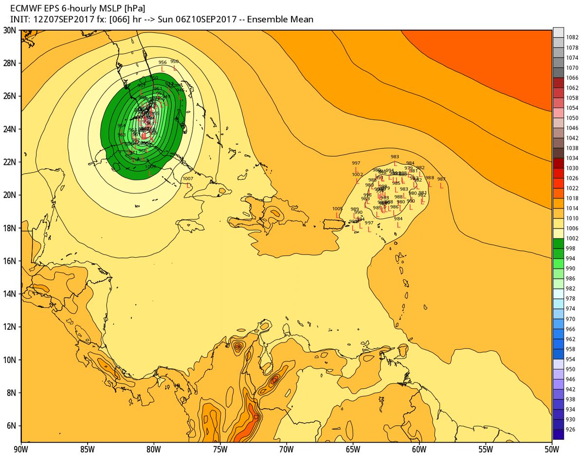
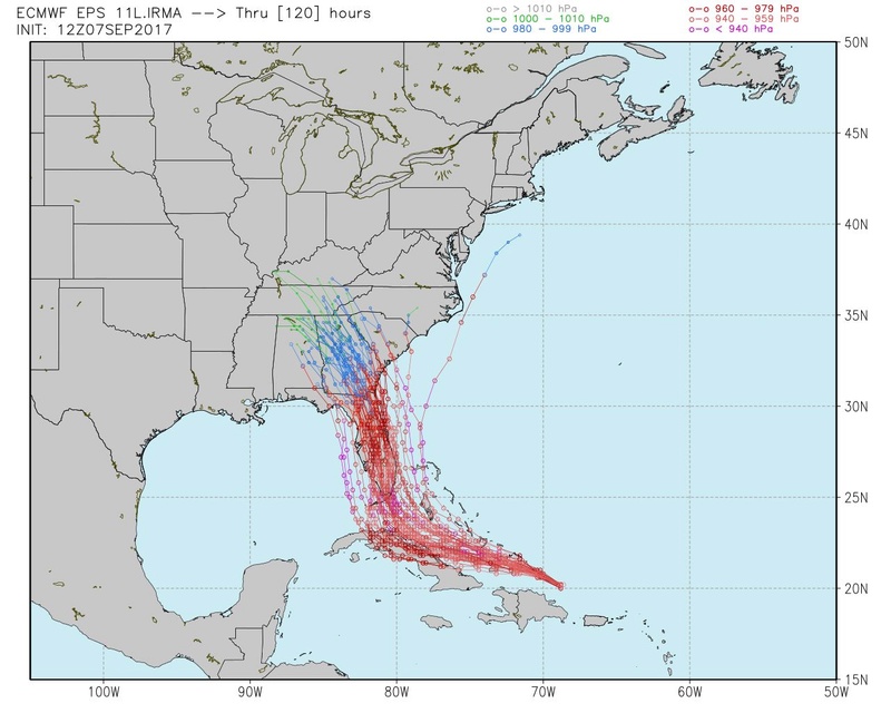
Hurricane Irma continues to have an impressive satellite presentation with a very distinct eye. There is not much more to add about the current intensity except that numerous data from the Air Force reconnaissance plane indicate that the winds remain at 150 kt. The environment along the future track of Irma is favorable for the hurricane to maintain most of its current intensity, although some fluctuations are likely due to eyewall replacement cycles which are difficult to predict. There are no obvious reasons why Irma should not remain a powerful major hurricane for the next 3 days while it is heading for Florida or its adjacent surroundings. Thereafter, an increase in the wind shear and the interaction with land should lead to gradual weakening. The best estimate of the initial motion is toward the west-northwest or 285 degrees at 14 kt. Irma is being steered by the flow around the south side of the subtropical ridge, but in 2 or 3 days the hurricane is expected to be located on the southwestern edge of the aforementioned ridge, and a turn to the northwest and north- northwest should then begin. The forecast track for the first 2 days was adjusted a little bit to the south given that the ridge to the north continues to be strong, and the ECMWF and HFIP corrected consensus (HCCA) models have shifted southward a little bit. These two models have been performing very well during Irma. This adjustment also results in a westward shift of the track near Florida and northward.

algae888- Advanced Forecaster

- Posts : 5311
Reputation : 46
Join date : 2013-02-05
Age : 61
Location : mt. vernon, new york
Re: Tracking Hurricane Irma: Part 2
![]() by SoulSingMG Thu Sep 07, 2017 7:02 pm
by SoulSingMG Thu Sep 07, 2017 7:02 pm

SoulSingMG- Senior Enthusiast
- Posts : 2853
Reputation : 74
Join date : 2013-12-11
Location : Long Island City, NY
Re: Tracking Hurricane Irma: Part 2
![]() by jmanley32 Thu Sep 07, 2017 7:04 pm
by jmanley32 Thu Sep 07, 2017 7:04 pm
It pulls a retrograde after hitting bermuda, what caused that verbatim? Not buying that, I just watched 2 weeks or so of Irma and nothing is prolly go happen, up here. Not to say its not interesting to track for our friends in FL, lets hope somehow this turns out to be a bit better thn shown currently. I will wait till within 5 days to believe if a storm may come up here.SoulSingMG wrote:Ummm no way, JOSE. 18z GFS has it hitting New England?! Lol
Last edited by jmanley32 on Thu Sep 07, 2017 8:27 pm; edited 1 time in total
jmanley32- Senior Enthusiast
- Posts : 20516
Reputation : 108
Join date : 2013-12-12
Age : 42
Location : Yonkers, NY
Re: Tracking Hurricane Irma: Part 2
![]() by WeatherBob Thu Sep 07, 2017 7:29 pm
by WeatherBob Thu Sep 07, 2017 7:29 pm
LEVEE FAILURE POTENTIAL
3 Troubling Lake Okeechobee Levee Facts 1
This entry was posted in Hurricane Analysis and tagged Hurricanes Lake Okeechobee levee protection south florida on February 26, 2013 by Michael Watkins.
Lake Okeechobee levee near Clewiston, FL
Lake Okeechobee levee near Clewiston, FL
Tonight, the Army Corps of Engineers held a public meeting in Clewiston, FL to discuss current “upgrades” to the 143 mile Herbert Hoover Dike, which protects much of south Florida should Lake Okeechobee flood or be pushed out of its banks during a hurricane.
The dike system cannot be counted on to protect against flooding during a significant weather event such as a direct hit from a hurricane or torrential rain event. Although there was little new information tonight, three significant facts remain.
1. The levee is expected to fail. I know that sounds bad, and it is. FEMA is apparently planning to update flood assessments this summer and redraw flood maps for Palm Beach and Martin counties. These flood maps are expected to be drawn as if the levee around Lake Okeechobee didn’t exist. In other words, they are not counting on the levees to protect against flooding.
2. The Herbert Hoover Dike is in the highest failure category of the Army Corps risk scale. Current efforts are being directed at reducing the risk category, but as it stands (and even after millions of dollars worth of improvements) the levee protecting the area still carries the highest risk classification (DSAC 1) of any dam in the United States.
3. There is no emergency spillway, nor is one planned to be built. There is no good, controlled way to drain off excess water from the lake should a large amount of rain fall in a short amount of time. Lake Okeechobee fills six times faster than it can be drained, and a foot of rainfall would result in 3 to 4 feet of water rise in the lake. Current levees will start to fail when the lake rises above 18.5 feet above mean sea level (it’s at roughly 14 feet currently), and significant levee problems are almost certain to occur when the lake reaches 20 feet over MSL.
Efforts to return the levee system to the original level of protection are expected to be completed…in 2017. However, the original design was done in the early 1930’s to 1950’s, hardly state of the art and surely not rated to withstand another hurricane season like 1926, 1928, 1945 or 1947.
I know I am not breaking any news here, but the Herbert Hoover Dike will fail, and significant parts of south Florida will be inundated with Lake Okeechobee flood waters. The question isn’t if, it’s when.

WeatherBob- Meteorologist
- Posts : 683
Reputation : 83
Join date : 2013-12-13
Location : Caldwell, NJ - NW Essex County - Altitude 500 FT
Re: Tracking Hurricane Irma: Part 2
![]() by weatherwatchermom Thu Sep 07, 2017 7:41 pm
by weatherwatchermom Thu Sep 07, 2017 7:41 pm

weatherwatchermom- Senior Enthusiast
- Posts : 3738
Reputation : 77
Join date : 2014-11-25
Age : 60
Location : Hazlet Township, NJ
Re: Tracking Hurricane Irma: Part 2
![]() by hyde345 Thu Sep 07, 2017 8:43 pm
by hyde345 Thu Sep 07, 2017 8:43 pm

hyde345- Pro Enthusiast
- Posts : 1082
Reputation : 48
Join date : 2013-01-08
Location : Hyde Park, NY
Re: Tracking Hurricane Irma: Part 2
![]() by mwilli5783 Thu Sep 07, 2017 8:52 pm
by mwilli5783 Thu Sep 07, 2017 8:52 pm
mwilli5783- Posts : 146
Reputation : 9
Join date : 2013-01-23
Age : 69
Location : hempstead n.y
Re: Tracking Hurricane Irma: Part 2
![]() by mwilli5783 Thu Sep 07, 2017 8:59 pm
by mwilli5783 Thu Sep 07, 2017 8:59 pm
mwilli5783- Posts : 146
Reputation : 9
Join date : 2013-01-23
Age : 69
Location : hempstead n.y
Re: Tracking Hurricane Irma: Part 2
![]() by amugs Thu Sep 07, 2017 9:37 pm
by amugs Thu Sep 07, 2017 9:37 pm
Umm and oh yeah he was teh chief engineer for teh rebuilding of the ld storm surge gates
for New Awlens!
I did a calculation with a structural engineer at my back to school night and we calculated that a high rise building with 175mph winds with a 100' base and 500' tall would have a 3,900,000 lbs force exerted on it horizontally. You can imagine teh catastrophic day after scenes of South Fla coastline Miami, Ft Lauderdale, Etc.
She wil pass over 85-90* bath water and just suck up this fuel and she is feeling the friction of teh land at this strength so she is basically avoiding land if yuo watch her wobble around PR and now Kooba.
Jose is going to be a major when it hits the leewards. Soon we will have Lee as well with teh wave off of Afrika.
_________________
Mugs
AKA:King: Snow Weenie
Self Proclaimed
WINTER 2014-15 : 55.12" +.02 for 6 coatings (avg. 35")
WINTER 2015-16 Total - 29.8" (Avg 35")
WINTER 2016-17 : 39.5" so far

amugs- Advanced Forecaster - Mod
- Posts : 15093
Reputation : 213
Join date : 2013-01-07
Age : 54
Location : Hillsdale,NJ
Re: Tracking Hurricane Irma: Part 2
![]() by Dunnzoo Thu Sep 07, 2017 9:52 pm
by Dunnzoo Thu Sep 07, 2017 9:52 pm
_________________
Janet
Snowfall winter of 2023-2024 17.5"
Snowfall winter of 2022-2023 6.0"
Snowfall winter of 2021-2022 17.6" 1" sleet 2/25/22
Snowfall winter of 2020-2021 51.1"
Snowfall winter of 2019-2020 8.5"
Snowfall winter of 2018-2019 25.1"
Snowfall winter of 2017-2018 51.9"
Snowfall winter of 2016-2017 45.6"
Snowfall winter of 2015-2016 29.5"
Snowfall winter of 2014-2015 50.55"
Snowfall winter of 2013-2014 66.5"

Dunnzoo- Senior Enthusiast - Mod
- Posts : 4891
Reputation : 68
Join date : 2013-01-11
Age : 62
Location : Westwood, NJ
Re: Tracking Hurricane Irma: Part 2
![]() by Joe Snow Thu Sep 07, 2017 9:58 pm
by Joe Snow Thu Sep 07, 2017 9:58 pm

Joe Snow- Pro Enthusiast
- Posts : 924
Reputation : 7
Join date : 2014-02-12
Age : 62
Location : Sanford Florida, Fmrly Kings Park, NY
Re: Tracking Hurricane Irma: Part 2
![]() by emokid51783 Thu Sep 07, 2017 10:07 pm
by emokid51783 Thu Sep 07, 2017 10:07 pm
emokid51783- Posts : 144
Reputation : 5
Join date : 2013-12-12
Age : 40
Location : Jersey City Heights, NJ
Re: Tracking Hurricane Irma: Part 2
![]() by Guest Thu Sep 07, 2017 10:15 pm
by Guest Thu Sep 07, 2017 10:15 pm
Guest- Guest
Re: Tracking Hurricane Irma: Part 2
![]() by jmanley32 Thu Sep 07, 2017 10:29 pm
by jmanley32 Thu Sep 07, 2017 10:29 pm
Miami will always exist, its a area, not like it will really be wiped off the map but extreme damage is very possible.emokid51783 wrote:Frank, talking to a friend, is it possible Miami doesn't exist after this storm
jmanley32- Senior Enthusiast
- Posts : 20516
Reputation : 108
Join date : 2013-12-12
Age : 42
Location : Yonkers, NY
Re: Tracking Hurricane Irma: Part 2
![]() by Guest Thu Sep 07, 2017 10:34 pm
by Guest Thu Sep 07, 2017 10:34 pm
Guest- Guest
Re: Tracking Hurricane Irma: Part 2
![]() by Sanchize06 Thu Sep 07, 2017 10:40 pm
by Sanchize06 Thu Sep 07, 2017 10:40 pm
Sanchize06- Senior Enthusiast
- Posts : 1041
Reputation : 21
Join date : 2013-02-05
Location : Union Beach, NJ

Sanchize06- Senior Enthusiast
- Posts : 1041
Reputation : 21
Join date : 2013-02-05
Location : Union Beach, NJ
Page 10 of 21 • 1 ... 6 ... 9, 10, 11 ... 15 ... 21 ![]()
|
|
|