December 11th 2019 Snow Potential
+25
brownie
jaydoy
algae888
Dunnzoo
1190ftalt
Grselig
Scullybutcher
dkodgis
skinsfan1177
jimv45
hyde345
billg315
Math23x7
CPcantmeasuresnow
frank 638
heehaw453
aiannone
amugs
docstox12
SENJsnowman
weatherwatchermom
Frank_Wx
jmanley32
Irish
sroc4
29 posters
Page 2 of 9 •  1, 2, 3, 4, 5, 6, 7, 8, 9
 Re: December 11th 2019 Snow Potential
Euro holds serve. Wide spread 2-5”
sroc4- Admin

- Posts : 8354
Join date : 2013-01-07
 Re: December 11th 2019 Snow Potential
https://mobile.twitter.com/jhomenuk/status/1203744714341670913
sroc4- Admin

- Posts : 8354
Join date : 2013-01-07
 Re: December 11th 2019 Snow Potential
Nice Scott hoping we can boost the totals closer to 5 along coast. Inland got their big one last time our turn and 3 to 6 is be very happy with. This doesn't look like a system that could produce crazy amounts though nam was very surprising. Sorry northern but hope man comes bit south.

jmanley32- Senior Enthusiast

- Posts : 20535
Reputation : 108
Join date : 2013-12-12
Age : 43
Location : Yonkers, NY
 Re: December 11th 2019 Snow Potential
sroc4 wrote:https://mobile.twitter.com/jhomenuk/status/1203744714341670913
thank you for the update..exciting December so far!

weatherwatchermom- Senior Enthusiast

- Posts : 3793
Reputation : 78
Join date : 2014-11-25
Location : Hazlet Township, NJ
 Re: December 11th 2019 Snow Potential
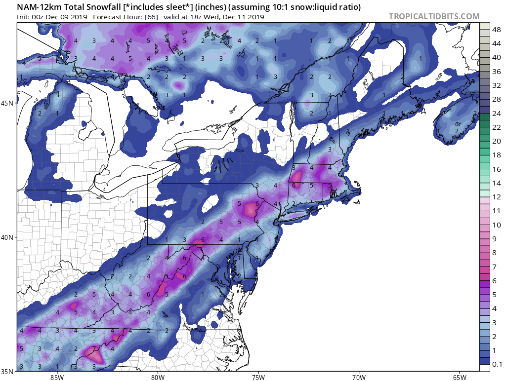
NAM has heavy snow for all except maybe far N & W this is a coastal special on this run at 7am, thats not good for those who have to commute no matter what.

jmanley32- Senior Enthusiast

- Posts : 20535
Reputation : 108
Join date : 2013-12-12
Age : 43
Location : Yonkers, NY
 Re: December 11th 2019 Snow Potential
Peeps,
The wave is gonna form along teh front and the snow will be see all the back to Memphis Tenn and possibly Little Rock and NE Texas.
The GFS has come aorund at 500mb to show the energy swing around the base of the trough and even holding back a bit allowing the cold air injection to get here and then the Jet Streak to allow the precip field to expand. This is a 2-4" type of event with WWA that most likely will go up tomorrow morning after the 0z runs tonight.
It will be a PITA for the commute with Delayed Openings and closing very possible for schools.
JET STREAK WOW
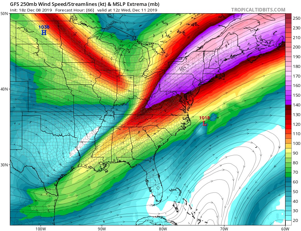
Purple areas show heavy snow rates 1-2" per hour type
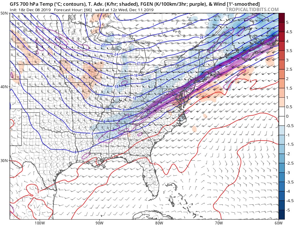
The wave is gonna form along teh front and the snow will be see all the back to Memphis Tenn and possibly Little Rock and NE Texas.
The GFS has come aorund at 500mb to show the energy swing around the base of the trough and even holding back a bit allowing the cold air injection to get here and then the Jet Streak to allow the precip field to expand. This is a 2-4" type of event with WWA that most likely will go up tomorrow morning after the 0z runs tonight.
It will be a PITA for the commute with Delayed Openings and closing very possible for schools.
JET STREAK WOW

Purple areas show heavy snow rates 1-2" per hour type

_________________
Mugs
AKA:King: Snow Weenie
Self Proclaimed
WINTER 2014-15 : 55.12" +.02 for 6 coatings (avg. 35")
WINTER 2015-16 Total - 29.8" (Avg 35")
WINTER 2016-17 : 39.5" so far

amugs- Advanced Forecaster - Mod

- Posts : 15095
Reputation : 213
Join date : 2013-01-07
Age : 54
Location : Hillsdale,NJ
 Re: December 11th 2019 Snow Potential
The energy off the NC coast if true will pop a weak coastal and enhance teh snowfall and slow up the boundary and thus the 4-6/8" swath that we are seeing in the SREFS and RGEM - they are onto this and we could be seeing a 2014 SB 2 surprise IMO.
City will lose an inch to two before stickage - not so about 10-15 mile outside the city for BL going to be 30/31*.
Great work here today.
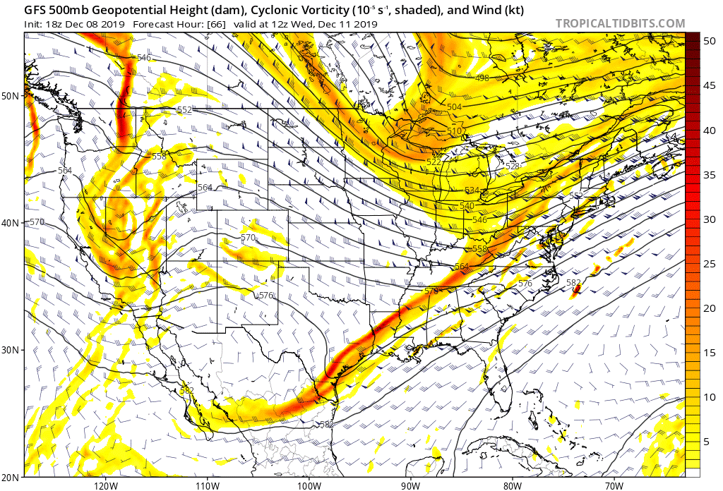
City will lose an inch to two before stickage - not so about 10-15 mile outside the city for BL going to be 30/31*.
Great work here today.

_________________
Mugs
AKA:King: Snow Weenie
Self Proclaimed
WINTER 2014-15 : 55.12" +.02 for 6 coatings (avg. 35")
WINTER 2015-16 Total - 29.8" (Avg 35")
WINTER 2016-17 : 39.5" so far

amugs- Advanced Forecaster - Mod

- Posts : 15095
Reputation : 213
Join date : 2013-01-07
Age : 54
Location : Hillsdale,NJ

aiannone- Senior Enthusiast - Mod

- Posts : 4815
Reputation : 92
Join date : 2013-01-07
Location : Saint James, LI (Northwest Suffolk Co.)

aiannone- Senior Enthusiast - Mod

- Posts : 4815
Reputation : 92
Join date : 2013-01-07
Location : Saint James, LI (Northwest Suffolk Co.)
 Re: December 11th 2019 Snow Potential
The nam seems to have the heavier precip more inland versus others being near the coast.

Irish- Pro Enthusiast

- Posts : 788
Reputation : 19
Join date : 2019-01-16
Age : 45
Location : Old Bridge, NJ
 Re: December 11th 2019 Snow Potential
The RGEM isnt in range yet for us, do you mean the swath of snow in the center of the country? It would be amazing to get a storm that big, nam was a tick up from 18z but not much for the coast or even inland pretty far N &W to get into 4-5.amugs wrote:The energy off the NC coast if true will pop a weak coastal and enhance teh snowfall and slow up the boundary and thus the 4-6/8" swath that we are seeing in the SREFS and RGEM - they are onto this and we could be seeing a 2014 SB 2 surprise IMO.
City will lose an inch to two before stickage - not so about 10-15 mile outside the city for BL going to be 30/31*.
Great work here today.

jmanley32- Senior Enthusiast

- Posts : 20535
Reputation : 108
Join date : 2013-12-12
Age : 43
Location : Yonkers, NY
 Re: December 11th 2019 Snow Potential
_________________
"In weather and in life, there's no winning and losing; there's only winning and learning."
WINTER 2012/2013 TOTALS 43.65"WINTER 2017/2018 TOTALS 62.85" WINTER 2022/2023 TOTALS 4.9"
WINTER 2013/2014 TOTALS 64.85"WINTER 2018/2019 TOTALS 14.25" WINTER 2023/2024 TOTALS 13.1"
WINTER 2014/2015 TOTALS 71.20"WINTER 2019/2020 TOTALS 6.35"
WINTER 2015/2016 TOTALS 35.00"WINTER 2020/2021 TOTALS 37.75"
WINTER 2016/2017 TOTALS 42.25"WINTER 2021/2022 TOTALS 31.65"

sroc4- Admin

- Posts : 8354
Reputation : 302
Join date : 2013-01-07
Location : Wading River, LI
 Re: December 11th 2019 Snow Potential
_________________
-Alex Iannone-

aiannone- Senior Enthusiast - Mod

- Posts : 4815
Reputation : 92
Join date : 2013-01-07
Location : Saint James, LI (Northwest Suffolk Co.)

jmanley32- Senior Enthusiast

- Posts : 20535
Reputation : 108
Join date : 2013-12-12
Age : 43
Location : Yonkers, NY
 Re: December 11th 2019 Snow Potential
Yeah it is the Kutchera (sorry frank) ratio map of the 12km nam, man the whole center there gets jipped out of several inches but hey I guess we will take what we can get, is that a warm nose? I believe it was stated that would not be a issue.

jmanley32- Senior Enthusiast

- Posts : 20535
Reputation : 108
Join date : 2013-12-12
Age : 43
Location : Yonkers, NY
 Re: December 11th 2019 Snow Potential
_________________
"In weather and in life, there's no winning and losing; there's only winning and learning."
WINTER 2012/2013 TOTALS 43.65"WINTER 2017/2018 TOTALS 62.85" WINTER 2022/2023 TOTALS 4.9"
WINTER 2013/2014 TOTALS 64.85"WINTER 2018/2019 TOTALS 14.25" WINTER 2023/2024 TOTALS 13.1"
WINTER 2014/2015 TOTALS 71.20"WINTER 2019/2020 TOTALS 6.35"
WINTER 2015/2016 TOTALS 35.00"WINTER 2020/2021 TOTALS 37.75"
WINTER 2016/2017 TOTALS 42.25"WINTER 2021/2022 TOTALS 31.65"

sroc4- Admin

- Posts : 8354
Reputation : 302
Join date : 2013-01-07
Location : Wading River, LI

CPcantmeasuresnow- Wx Statistician Guru

- Posts : 7274
Reputation : 230
Join date : 2013-01-07
Age : 103
Location : Eastern Orange County, NY
Math23x7- Wx Statistician Guru

- Posts : 2379
Reputation : 68
Join date : 2013-01-08
 Re: December 11th 2019 Snow Potential
So far the twc has me down for 1 to 3 inches of snow  hopefully this will change
frank 638- Senior Enthusiast

- Posts : 2843
Reputation : 37
Join date : 2016-01-01
Age : 40
Location : bronx ny
 Re: December 11th 2019 Snow Potential
The 6z nam cut everything way down extremely short duration of snow. Now gfs had roughly double nam lol

jmanley32- Senior Enthusiast

- Posts : 20535
Reputation : 108
Join date : 2013-12-12
Age : 43
Location : Yonkers, NY
 Re: December 11th 2019 Snow Potential
Euro cut back too
_________________
"In weather and in life, there's no winning and losing; there's only winning and learning."
WINTER 2012/2013 TOTALS 43.65"WINTER 2017/2018 TOTALS 62.85" WINTER 2022/2023 TOTALS 4.9"
WINTER 2013/2014 TOTALS 64.85"WINTER 2018/2019 TOTALS 14.25" WINTER 2023/2024 TOTALS 13.1"
WINTER 2014/2015 TOTALS 71.20"WINTER 2019/2020 TOTALS 6.35"
WINTER 2015/2016 TOTALS 35.00"WINTER 2020/2021 TOTALS 37.75"
WINTER 2016/2017 TOTALS 42.25"WINTER 2021/2022 TOTALS 31.65"

sroc4- Admin

- Posts : 8354
Reputation : 302
Join date : 2013-01-07
Location : Wading River, LI
 Re: December 11th 2019 Snow Potential
I think I clicked report by accident Scott small screen on phone sorry bout that . I was saying looks like really short duration as 1 to 3 with ratios can't last but a hour or 2 at most. And mugs was talk bout 1 to 2 inch per hour rates. If this verifies I don't see snow that heavy unless it lasts a half HR lol

jmanley32- Senior Enthusiast

- Posts : 20535
Reputation : 108
Join date : 2013-12-12
Age : 43
Location : Yonkers, NY
 Re: December 11th 2019 Snow Potential
still 2 days out plenty time to change. Of course on all the models I appear to be between banding with many others. Man we can't catch a break lolsroc4 wrote:Euro cut back too

jmanley32- Senior Enthusiast

- Posts : 20535
Reputation : 108
Join date : 2013-12-12
Age : 43
Location : Yonkers, NY
 Re: December 11th 2019 Snow Potential
Quickly looking at the jet streak it appears a little less robust and a tad further NE relative to the past few days. Not a good thing. This is the main driver to expanding The precip shield without a Defined LP.
_________________
"In weather and in life, there's no winning and losing; there's only winning and learning."
WINTER 2012/2013 TOTALS 43.65"WINTER 2017/2018 TOTALS 62.85" WINTER 2022/2023 TOTALS 4.9"
WINTER 2013/2014 TOTALS 64.85"WINTER 2018/2019 TOTALS 14.25" WINTER 2023/2024 TOTALS 13.1"
WINTER 2014/2015 TOTALS 71.20"WINTER 2019/2020 TOTALS 6.35"
WINTER 2015/2016 TOTALS 35.00"WINTER 2020/2021 TOTALS 37.75"
WINTER 2016/2017 TOTALS 42.25"WINTER 2021/2022 TOTALS 31.65"

sroc4- Admin

- Posts : 8354
Reputation : 302
Join date : 2013-01-07
Location : Wading River, LI
 Re: December 11th 2019 Snow Potential
Predicted temps for Wednesday are trending warmer and snowfall amounts are lessening.

Irish- Pro Enthusiast

- Posts : 788
Reputation : 19
Join date : 2019-01-16
Age : 45
Location : Old Bridge, NJ
 Re: December 11th 2019 Snow Potential
Great still crossing fingers this trends back to past few days. And I thought you guys were sure temps wouldn't be a issue now it's go be warmer wed?

jmanley32- Senior Enthusiast

- Posts : 20535
Reputation : 108
Join date : 2013-12-12
Age : 43
Location : Yonkers, NY
 Re: December 11th 2019 Snow Potential
Yeah. Give it until tomorrow morning before throwing in the towel with the caveat to keep expectations @ c-1". These frontal passages with backend snow are really rare producers around here. One way they can produce is if the Atlantic had some more support to slow down the flow or the trough was really sharp. Neither of those things are on the table. 
heehaw453- Advanced Forecaster

- Posts : 3906
Reputation : 86
Join date : 2014-01-20
Location : Bedminster Township, PA Elevation 600' ASL
Page 2 of 9 •  1, 2, 3, 4, 5, 6, 7, 8, 9
Permissions in this forum:
You cannot reply to topics in this forum|
|
|

 Home
Home