Dec 16-17 Snow/Ice potential storm
+24
Gator99
essexcountypete
Vinnydula
DAYBLAZER
SENJsnowman
Grselig
bloc1357
weatherwatchermom
algae888
Irish
bobjohnsonforthehall
jimv45
Dunnzoo
billg315
frank 638
aiannone
hyde345
docstox12
Frank_Wx
CPcantmeasuresnow
sroc4
heehaw453
jmanley32
amugs
28 posters
Page 1 of 11
Page 1 of 11 • 1, 2, 3 ... 9, 10, 11 
 Dec 16-17 Snow/Ice potential storm
Three straight days of Euro runs showing a snow to possible serious to crippling ice storm for majority of the posters here.
JMAN requested and I concur.
From my personal experiences with the weak SWFE in NNJ, they come in quicker than modelled, the CAD holds on, we get a good front end thump of 2-4" range, we get a sleet, ZR to end as snizzle and then cold on the backside swings in as the LP departs. They move quicker than modeled so look for tjis in the coming runs.
EURO has been pretty steadfast with this now to ice scenario for a couple of days now for CPA, NEPA, NNJ, LHV and CT. GFS has bounces around like a three year old in a bouncy house.
CAD usually wins out longer in these set ups where u get a good front end thump as well.
Just my .02c observation.
Question how fast, shallow or deep is that 850 warm tongue unlike a coastal here which is usually stronger and faster??
_________________
Mugs
AKA:King: Snow Weenie
Self Proclaimed
WINTER 2014-15 : 55.12" +.02 for 6 coatings (avg. 35")
WINTER 2015-16 Total - 29.8" (Avg 35")
WINTER 2016-17 : 39.5" so far

amugs- Advanced Forecaster - Mod

- Posts : 15095
Reputation : 213
Join date : 2013-01-07
Age : 54
Location : Hillsdale,NJ
 Re: Dec 16-17 Snow/Ice potential storm
EURO = U-G-L-Y


_________________
Mugs
AKA:King: Snow Weenie
Self Proclaimed
WINTER 2014-15 : 55.12" +.02 for 6 coatings (avg. 35")
WINTER 2015-16 Total - 29.8" (Avg 35")
WINTER 2016-17 : 39.5" so far

amugs- Advanced Forecaster - Mod

- Posts : 15095
Reputation : 213
Join date : 2013-01-07
Age : 54
Location : Hillsdale,NJ
 Re: Dec 16-17 Snow/Ice potential storm
This looks to be a Monday afternoon to Tuesday early AM event.
_________________
Mugs
AKA:King: Snow Weenie
Self Proclaimed
WINTER 2014-15 : 55.12" +.02 for 6 coatings (avg. 35")
WINTER 2015-16 Total - 29.8" (Avg 35")
WINTER 2016-17 : 39.5" so far

amugs- Advanced Forecaster - Mod

- Posts : 15095
Reputation : 213
Join date : 2013-01-07
Age : 54
Location : Hillsdale,NJ
 Re: Dec 16-17 Snow/Ice potential storm
I wonder if the ice or snow will hold on just a bit longer into this area which is pretty close to ct shoreline which is shown to get a lot of ice. Has me changing to rain pretty quick but even .18 ice is a big issue.
Should be interesting what sr models show for snow and or ice issues.
Should be interesting what sr models show for snow and or ice issues.

jmanley32- Senior Enthusiast

- Posts : 20535
Reputation : 108
Join date : 2013-12-12
Age : 43
Location : Yonkers, NY
 Re: Dec 16-17 Snow/Ice potential storm
0Z Euro continues to tick colder and further south. This has support from other guidance too like NAM. Brings sig snow 4-6" from Trenton northward. The ice would be severe away from coast from EPA towards LHV.
GFS not as ominous, but seems like the models are picking up more on the block. Once this current storm settles in a better handle we'll have.
The heights shown here are conducive for further south track.

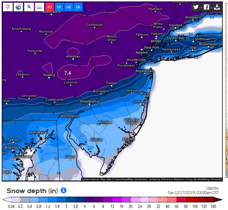
GFS not as ominous, but seems like the models are picking up more on the block. Once this current storm settles in a better handle we'll have.
The heights shown here are conducive for further south track.


heehaw453- Advanced Forecaster

- Posts : 3906
Reputation : 86
Join date : 2014-01-20
Location : Bedminster Township, PA Elevation 600' ASL
 Re: Dec 16-17 Snow/Ice potential storm
heehaw453 wrote:0Z Euro continues to tick colder and further south. This has support from other guidance too like NAM. Brings sig snow 4-6" from Trenton northward. The ice would be severe away from coast from EPA towards LHV.
GFS not as ominous, but seems like the models are picking up more on the block. Once this current storm settles in a better handle we'll have.
The heights shown here are conducive for further south track.
Ice potential is real crappy. If euro soln occurs verbatim it’s not good. Let’s hope it backs off. Btw Heehaw I echo the sentiments of the others. You’ve been doing a phenomenal job with your analysis. Keep it up!!
_________________
"In weather and in life, there's no winning and losing; there's only winning and learning."
WINTER 2012/2013 TOTALS 43.65"WINTER 2017/2018 TOTALS 62.85" WINTER 2022/2023 TOTALS 4.9"
WINTER 2013/2014 TOTALS 64.85"WINTER 2018/2019 TOTALS 14.25" WINTER 2023/2024 TOTALS 13.1"
WINTER 2014/2015 TOTALS 71.20"WINTER 2019/2020 TOTALS 6.35"
WINTER 2015/2016 TOTALS 35.00"WINTER 2020/2021 TOTALS 37.75"
WINTER 2016/2017 TOTALS 42.25"WINTER 2021/2022 TOTALS 31.65"

sroc4- Admin

- Posts : 8354
Reputation : 302
Join date : 2013-01-07
Location : Wading River, LI
 Re: Dec 16-17 Snow/Ice potential storm
heehaw453 wrote:0Z Euro continues to tick colder and further south. This has support from other guidance too like NAM. Brings sig snow 4-6" from Trenton northward. The ice would be severe away from coast from EPA towards LHV.
GFS not as ominous, but seems like the models are picking up more on the block. Once this current storm settles in a better handle we'll have.
The heights shown here are conducive for further south track.
Booooommm Haw!!!
Excellent post. The models as I have been harping on are seeing the CAD signature, cold air damping peeps. That warm tonguenof air is weak at 850 so the push is not great due to a weaker system and more cofluen with the block. I wait to see the RGEM and Hi Res Models tonight for more confirmation.
The LP is weaker and there is better separation between the front energy and middle energy coming out of the southwest. The Euro is notorious for holding thus energy back but in this case seems to be handling this and the Cad sign much better.
_________________
Mugs
AKA:King: Snow Weenie
Self Proclaimed
WINTER 2014-15 : 55.12" +.02 for 6 coatings (avg. 35")
WINTER 2015-16 Total - 29.8" (Avg 35")
WINTER 2016-17 : 39.5" so far

amugs- Advanced Forecaster - Mod

- Posts : 15095
Reputation : 213
Join date : 2013-01-07
Age : 54
Location : Hillsdale,NJ
 Re: Dec 16-17 Snow/Ice potential storm
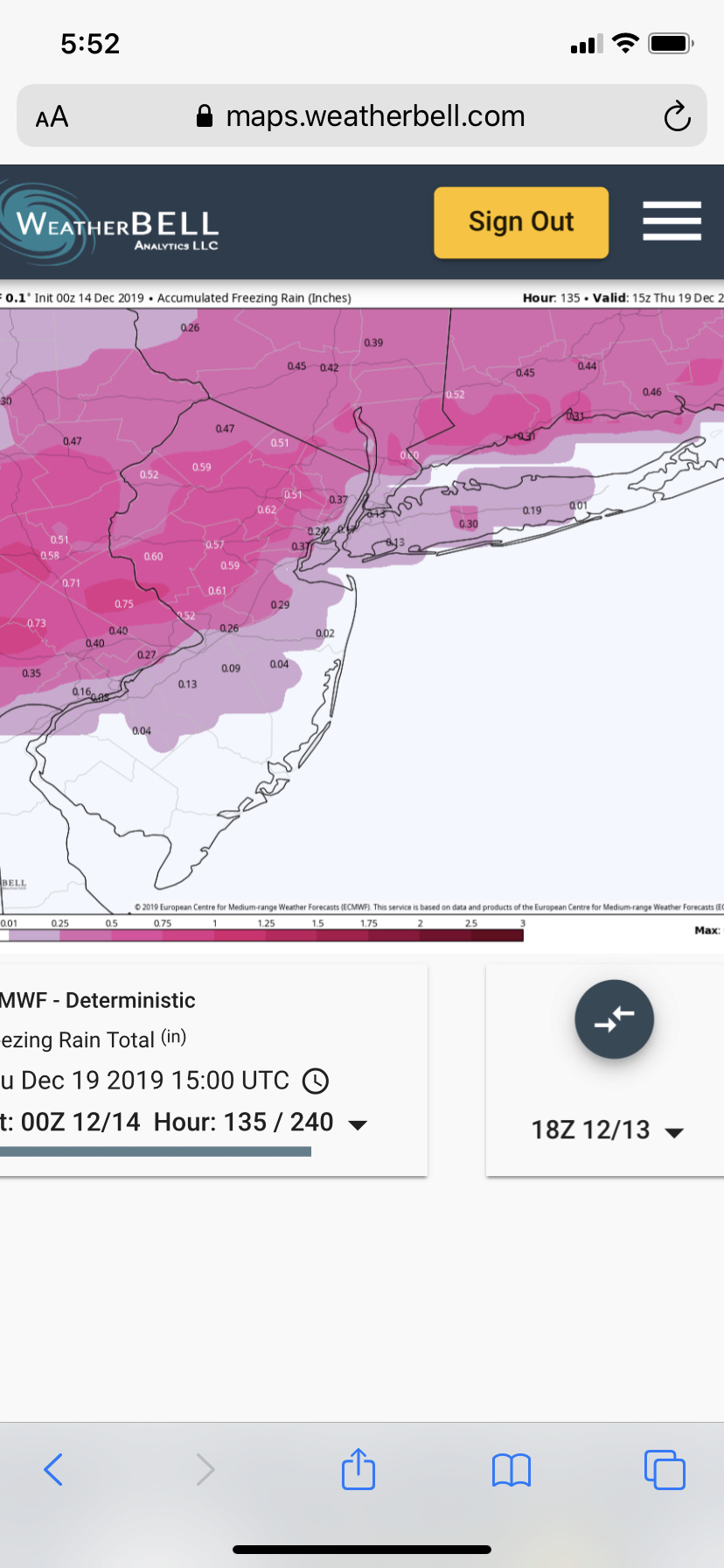
Yikes! That white 0.60 in westchester is westchester airport near where I work, no way in hell I will be driving if thats OTG. I think snow encased in ice on the trees is worse than if it iced forst and then snowed, this solution if happened would not allow for snow to come off the trees and lower weight thus creating even more branch breakage. We will see but am loving that I am solidly in a 3-5 inche area on Euro, hoping tha tcomes true. Only think is how much of the frz, changes to just rain just north of the city.


jmanley32- Senior Enthusiast

- Posts : 20535
Reputation : 108
Join date : 2013-12-12
Age : 43
Location : Yonkers, NY
 Re: Dec 16-17 Snow/Ice potential storm
NAM is at the end of its range but has no snow except far northern folks but just ice for majority of the further south areas, maybe a inch of snow. stark difference from the euro verbatim.

jmanley32- Senior Enthusiast

- Posts : 20535
Reputation : 108
Join date : 2013-12-12
Age : 43
Location : Yonkers, NY
 Re: Dec 16-17 Snow/Ice potential storm
amugs wrote:heehaw453 wrote:0Z Euro continues to tick colder and further south. This has support from other guidance too like NAM. Brings sig snow 4-6" from Trenton northward. The ice would be severe away from coast from EPA towards LHV.
GFS not as ominous, but seems like the models are picking up more on the block. Once this current storm settles in a better handle we'll have.
The heights shown here are conducive for further south track.
Booooommm Haw!!!
Excellent post. The models as I have been harping on are seeing the CAD signature, cold air damping peeps. That warm tonguenof air is weak at 850 so the push is not great due to a weaker system and more cofluen with the block. I wait to see the RGEM and Hi Res Models tonight for more confirmation.
The LP is weaker and there is better separation between the front energy and middle energy coming out of the southwest. The Euro is notorious for holding thus energy back but in this case seems to be handling this and the Cad sign much better.
I would have to think that Euro map is including the ice that will fall as snow that's why the inflated totals? Although it does say snow depth so I'm not sure. It's hard to believe NEPA, NWNJ and the HV will get 6-8 inches of snow from this setup with the mid levels as consistently warming as most models have shown. It has defintely trended colder during the last 24 hours though. My area has gone from projected highs on Tuesday of 32 as of Thursdays maps, 45 as of yesterdays maps and now 38 as of this mornings. It seems to change quite a bit with the different models although as Mugs has pointed out the Euro seems ot have been very consistent with this the last four days.
Definitely worth tracking today.

CPcantmeasuresnow- Wx Statistician Guru

- Posts : 7274
Reputation : 230
Join date : 2013-01-07
Age : 103
Location : Eastern Orange County, NY
 Re: Dec 16-17 Snow/Ice potential storm
The snow on this is higher but the wxbell snow map that does not include ice is about 3-5 area wide before the changeover. So seems the front end thump will be very heavy if this were to happen.CPcantmeasuresnow wrote:amugs wrote:heehaw453 wrote:0Z Euro continues to tick colder and further south. This has support from other guidance too like NAM. Brings sig snow 4-6" from Trenton northward. The ice would be severe away from coast from EPA towards LHV.
GFS not as ominous, but seems like the models are picking up more on the block. Once this current storm settles in a better handle we'll have.
The heights shown here are conducive for further south track.
Booooommm Haw!!!
Excellent post. The models as I have been harping on are seeing the CAD signature, cold air damping peeps. That warm tonguenof air is weak at 850 so the push is not great due to a weaker system and more cofluen with the block. I wait to see the RGEM and Hi Res Models tonight for more confirmation.
The LP is weaker and there is better separation between the front energy and middle energy coming out of the southwest. The Euro is notorious for holding thus energy back but in this case seems to be handling this and the Cad sign much better.
I would have to think that Euro map is including the ice that will fall as snow that's why the inflated totals? Although it does say snow depth so I'm not sure. It's hard to believe NEPA, NWNJ and the HV will get 6-8 inches of snow from this setup with the mid levels as consistently warming as most models have shown. It has defintely trended colder during the last 24 hours though. My area has gone from projected highs on Tuesday of 32 as of Thursdays maps, 45 as of yesterdays maps and now 38 as of this mornings. It seems to change quite a bit with the different models although as Mugs has pointed out the Euro seems ot have been very consistent with this the last four days.
Definitely worth tracking today.

jmanley32- Senior Enthusiast

- Posts : 20535
Reputation : 108
Join date : 2013-12-12
Age : 43
Location : Yonkers, NY
 Re: Dec 16-17 Snow/Ice potential storm
Flexing its muscle *again* is the -NAO. With the way things have gone so far this month and based off how things are modeled to go in the future, the NAO will be the most important factor in determining whether we see more rain or the possibility of winter weather.
There are several reasons why I believe a significant winter storm will impact us on Monday.
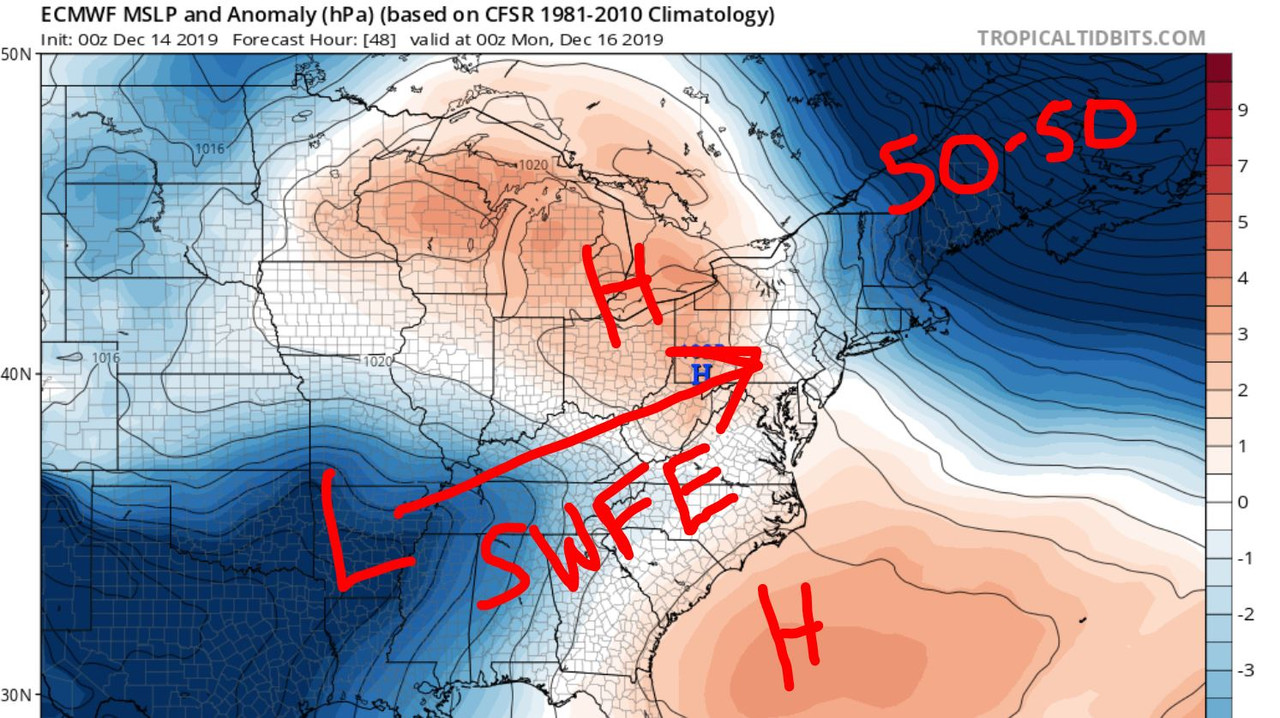
Sunday night the EURO shows a developing LP system squeezed between two areas of High Pressure. There is very potent upper level energy digging into the southwest CONUS at this time. In response, a SE Ridge is trying to develop off the southeast coast. Further upstream the jet stream is under extreme pressure. A 50-50 Low has nowhere to move because of the stationary ridge over Greenland, aka -NAO.
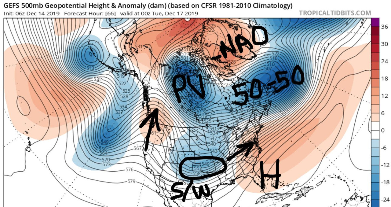
Here is a zoomed out view valid Monday night around the time the storm is expected to occur. The PAC energy, or southern short wave, has a path mapped out for itself because of the upper air anomalies I just spoke about. The only question regarding the track of this low is exactly how far north can it get until the blocking turns it east.

The issue is the aforementioned -PNA energy over the Rockies. That trough is so positively tilted it gives the SE Ridge greater influence to overcome the blockiness over New England. While there will be a moderate initial thump of snow/ice, I do expect the surface low tracks either over or just north of our area meaning majority will change to rain.
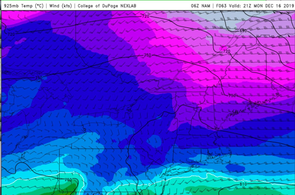

That said, low level cold across the Northeast will make it difficult for precip to change quickly from snow to rain. Instead, there will be a period where snow changes to freezing rain before a plain rain. The 06z NAM had 925mb temps not getting above freezing until 7pm Monday night. However, 850mb in that same time slot remain below freezing. The contrast of freezing temps over various levels of the atmosphere usually spells trouble for ice.
We'll see where today's model runs take us but I am envisioning a swath of 2-4" snow, 4"+ for whoever is lucky enough to be below freezing but JUST above the baroclinic zone because that is where the best rates occur. The challenging part is figuring out how long, if any, freezing rain falls. I do think areas N&W of NYC are at a greater risk to seeing freezing rain than those around NYC Metro. Let's see what today brings!
There are several reasons why I believe a significant winter storm will impact us on Monday.

Sunday night the EURO shows a developing LP system squeezed between two areas of High Pressure. There is very potent upper level energy digging into the southwest CONUS at this time. In response, a SE Ridge is trying to develop off the southeast coast. Further upstream the jet stream is under extreme pressure. A 50-50 Low has nowhere to move because of the stationary ridge over Greenland, aka -NAO.

Here is a zoomed out view valid Monday night around the time the storm is expected to occur. The PAC energy, or southern short wave, has a path mapped out for itself because of the upper air anomalies I just spoke about. The only question regarding the track of this low is exactly how far north can it get until the blocking turns it east.

The issue is the aforementioned -PNA energy over the Rockies. That trough is so positively tilted it gives the SE Ridge greater influence to overcome the blockiness over New England. While there will be a moderate initial thump of snow/ice, I do expect the surface low tracks either over or just north of our area meaning majority will change to rain.


That said, low level cold across the Northeast will make it difficult for precip to change quickly from snow to rain. Instead, there will be a period where snow changes to freezing rain before a plain rain. The 06z NAM had 925mb temps not getting above freezing until 7pm Monday night. However, 850mb in that same time slot remain below freezing. The contrast of freezing temps over various levels of the atmosphere usually spells trouble for ice.
We'll see where today's model runs take us but I am envisioning a swath of 2-4" snow, 4"+ for whoever is lucky enough to be below freezing but JUST above the baroclinic zone because that is where the best rates occur. The challenging part is figuring out how long, if any, freezing rain falls. I do think areas N&W of NYC are at a greater risk to seeing freezing rain than those around NYC Metro. Let's see what today brings!
_________________
_______________________________________________________________________________________________________
CLICK HERE to view NJ Strong Snowstorm Classifications
 Re: Dec 16-17 Snow/Ice potential storm
Frank_Wx wrote:Flexing its muscle *again* is the -NAO. With the way things have gone so far this month and based off how things are modeled to go in the future, the NAO will be the most important factor in determining whether we see more rain or the possibility of winter weather.
There are several reasons why I believe a significant winter storm will impact us on Monday.
Sunday night the EURO shows a developing LP system squeezed between two areas of High Pressure. There is very potent upper level energy digging into the southwest CONUS at this time. In response, a SE Ridge is trying to develop off the southeast coast. Further upstream the jet stream is under extreme pressure. A 50-50 Low has nowhere to move because of the stationary ridge over Greenland, aka -NAO.
Here is a zoomed out view valid Monday night around the time the storm is expected to occur. The PAC energy, or southern short wave, has a path mapped out for itself because of the upper air anomalies I just spoke about. The only question regarding the track of this low is exactly how far north can it get until the blocking turns it east.
The issue is the aforementioned -PNA energy over the Rockies. That trough is so positively tilted it gives the SE Ridge greater influence to overcome the blockiness over New England. While there will be a moderate initial thump of snow/ice, I do expect the surface low tracks either over or just north of our area meaning majority will change to rain.
That said, low level cold across the Northeast will make it difficult for precip to change quickly from snow to rain. Instead, there will be a period where snow changes to freezing rain before a plain rain. The 06z NAM had 925mb temps not getting above freezing until 7pm Monday night. However, 850mb in that same time slot remain below freezing. The contrast of freezing temps over various levels of the atmosphere usually spells trouble for ice.
We'll see where today's model runs take us but I am envisioning a swath of 2-4" snow, 4"+ for whoever is lucky enough to be below freezing but JUST above the baroclinic zone because that is where the best rates occur. The challenging part is figuring out how long, if any, freezing rain falls. I do think areas N&W of NYC are at a greater risk to seeing freezing rain than those around NYC Metro. Let's see what today brings!
Great post. I think the setup is very good for a thump of accumulating snow followed by ice. Surface temp will allow for good sticking on all surfaces. Blocking can really mess with the models and things can become more interesting really fast.
heehaw453- Advanced Forecaster

- Posts : 3906
Reputation : 86
Join date : 2014-01-20
Location : Bedminster Township, PA Elevation 600' ASL
 Re: Dec 16-17 Snow/Ice potential storm
Frank_Wx wrote:Flexing its muscle *again* is the -NAO. With the way things have gone so far this month and based off how things are modeled to go in the future, the NAO will be the most important factor in determining whether we see more rain or the possibility of winter weather.
There are several reasons why I believe a significant winter storm will impact us on Monday.
Sunday night the EURO shows a developing LP system squeezed between two areas of High Pressure. There is very potent upper level energy digging into the southwest CONUS at this time. In response, a SE Ridge is trying to develop off the southeast coast. Further upstream the jet stream is under extreme pressure. A 50-50 Low has nowhere to move because of the stationary ridge over Greenland, aka -NAO.
Here is a zoomed out view valid Monday night around the time the storm is expected to occur. The PAC energy, or southern short wave, has a path mapped out for itself because of the upper air anomalies I just spoke about. The only question regarding the track of this low is exactly how far north can it get until the blocking turns it east.
The issue is the aforementioned -PNA energy over the Rockies. That trough is so positively tilted it gives the SE Ridge greater influence to overcome the blockiness over New England. While there will be a moderate initial thump of snow/ice, I do expect the surface low tracks either over or just north of our area meaning majority will change to rain.
That said, low level cold across the Northeast will make it difficult for precip to change quickly from snow to rain. Instead, there will be a period where snow changes to freezing rain before a plain rain. The 06z NAM had 925mb temps not getting above freezing until 7pm Monday night. However, 850mb in that same time slot remain below freezing. The contrast of freezing temps over various levels of the atmosphere usually spells trouble for ice.
We'll see where today's model runs take us but I am envisioning a swath of 2-4" snow, 4"+ for whoever is lucky enough to be below freezing but JUST above the baroclinic zone because that is where the best rates occur. The challenging part is figuring out how long, if any, freezing rain falls. I do think areas N&W of NYC are at a greater risk to seeing freezing rain than those around NYC Metro. Let's see what today brings!
Thanks Frank, great write up.

CPcantmeasuresnow- Wx Statistician Guru

- Posts : 7274
Reputation : 230
Join date : 2013-01-07
Age : 103
Location : Eastern Orange County, NY
 Re: Dec 16-17 Snow/Ice potential storm
Don't underestimate the block and what it will do to the different levels of a storm especially a SWFE which is weak and doesn't have the strength to pull the warm tongue through as we see with coastals.
Hi Res producst will catch up to this today and tomorrow as our departing coastal gets anchored in.
1993-94 peeps as the boys from BAMWx have been harping on since late November. A mere 30 -50 mile SE press woudl be even worse for the NYC Metro
ICE ICE BABY!!


Please don't say well .10 of ice is nothing - its not.
Hi Res producst will catch up to this today and tomorrow as our departing coastal gets anchored in.
1993-94 peeps as the boys from BAMWx have been harping on since late November. A mere 30 -50 mile SE press woudl be even worse for the NYC Metro
ICE ICE BABY!!


Please don't say well .10 of ice is nothing - its not.
_________________
Mugs
AKA:King: Snow Weenie
Self Proclaimed
WINTER 2014-15 : 55.12" +.02 for 6 coatings (avg. 35")
WINTER 2015-16 Total - 29.8" (Avg 35")
WINTER 2016-17 : 39.5" so far

amugs- Advanced Forecaster - Mod

- Posts : 15095
Reputation : 213
Join date : 2013-01-07
Age : 54
Location : Hillsdale,NJ
 Re: Dec 16-17 Snow/Ice potential storm
Oh it sure is, it wont cuase lots of trees to break but even a glaze will make for terrible accident. I recall a few years ago where Jersey had just a glaze and trucks were flying everywhere. Might not be WSW they issue but ice storm warnings. That would be something, I dont think I have ever been under one, not that I can remember anyways. Lets see how the next day goes but ya mugs this is looking like it could be the ice and snow storm we have been avoiding for many years.amugs wrote:Don't underestimate the block and what it will do to the different levels of a storm especially a SWFE which is weak and doesn't have the strength to pull the warm tongue through as we see with coastals.
Hi Res producst will catch up to this today and tomorrow as our departing coastal gets anchored in.
1993-94 peeps as the boys from BAMWx have been harping on since late November. A mere 30 -50 mile SE press woudl be even worse for the NYC Metro
ICE ICE BABY!!
Please don't say well .10 of ice is nothing - its not.

jmanley32- Senior Enthusiast

- Posts : 20535
Reputation : 108
Join date : 2013-12-12
Age : 43
Location : Yonkers, NY
 Re: Dec 16-17 Snow/Ice potential storm
These ice maps are not going away and that is very concerning to me.Downed tree limbs, power lines are bad enough after T Storm, but in the winter with cold temps, not good.Hoping for our area this gets much colder and mostly snow, or torch and have a front end thump snow to rain.

docstox12- Wx Statistician Guru

- Posts : 8530
Reputation : 222
Join date : 2013-01-07
Age : 73
Location : Monroe NY
 Re: Dec 16-17 Snow/Ice potential storm
MOMMA MIA EURO!!!
JESUS H this would be crippling - not pumping this but verbatim this would be crippling
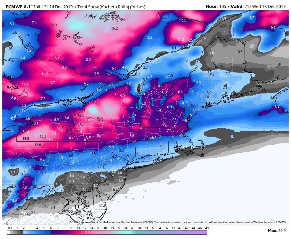
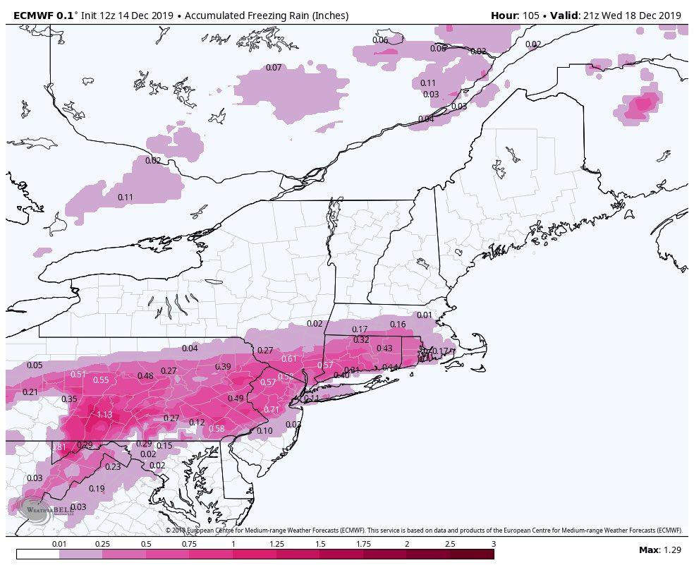
JESUS H this would be crippling - not pumping this but verbatim this would be crippling


_________________
Mugs
AKA:King: Snow Weenie
Self Proclaimed
WINTER 2014-15 : 55.12" +.02 for 6 coatings (avg. 35")
WINTER 2015-16 Total - 29.8" (Avg 35")
WINTER 2016-17 : 39.5" so far

amugs- Advanced Forecaster - Mod

- Posts : 15095
Reputation : 213
Join date : 2013-01-07
Age : 54
Location : Hillsdale,NJ
 Re: Dec 16-17 Snow/Ice potential storm
Sorry but the track is further south again by about 25 miles this run and the block is growing thus pressing on teh storm and allowing the CAD to hang in and drive a tad more south.
The EURO is locked peeps and I have been on this with it since Wednesday, last week when I posted on it for my bday - well not an ice storm as such but a snowstorm - dont doubt Big Momma and her love for Mugs LOL!
The EURO is locked peeps and I have been on this with it since Wednesday, last week when I posted on it for my bday - well not an ice storm as such but a snowstorm - dont doubt Big Momma and her love for Mugs LOL!
_________________
Mugs
AKA:King: Snow Weenie
Self Proclaimed
WINTER 2014-15 : 55.12" +.02 for 6 coatings (avg. 35")
WINTER 2015-16 Total - 29.8" (Avg 35")
WINTER 2016-17 : 39.5" so far

amugs- Advanced Forecaster - Mod

- Posts : 15095
Reputation : 213
Join date : 2013-01-07
Age : 54
Location : Hillsdale,NJ
 Re: Dec 16-17 Snow/Ice potential storm
amugs wrote:MOMMA MIA EURO!!!
JESUS H this would be crippling - not pumping this but verbatim this would be crippling
Yes, the 2-4" inches of snow is definitely not the story here. The ice potential is real with this. I don't think storm is done trending south yet either which won't make this any better. I'm hoping for warmer air at surface, but not feeling good about a quick change to rain.
heehaw453- Advanced Forecaster

- Posts : 3906
Reputation : 86
Join date : 2014-01-20
Location : Bedminster Township, PA Elevation 600' ASL
 Re: Dec 16-17 Snow/Ice potential storm
Yes it sure did press south, now southern westchester is fully in the ice threat and never really changes to rain, only at the very end and very light, this is getting serious if its true. Mugs I am with you, usually when I see ice like this I have a bad feeling that it will happen as we rarely see this and it often backs off but that does not appear to be the case being about 48 hrs out now.

jmanley32- Senior Enthusiast

- Posts : 20535
Reputation : 108
Join date : 2013-12-12
Age : 43
Location : Yonkers, NY

jmanley32- Senior Enthusiast

- Posts : 20535
Reputation : 108
Join date : 2013-12-12
Age : 43
Location : Yonkers, NY
 Re: Dec 16-17 Snow/Ice potential storm
Anthony Masiello
@antmasiello
After our midday burst of snow/sleet over E PA/NJ, mid levels begin to warm during the evening. However, low level winds appear to remain N/NE into the I-95 corridor. The potential exists for prolonged ZR into the night, even close to the cities.
Think about this case, for example: a quick FGEN snow/sleet accum for northern Mid Atlantic Monday could help keep the warm front suppressed during the evening/night as the surface cyclone tracks offshore. That can hold colder surfaces, esp. if there's a little speed to NE flow.
Wind Map from PB on 33& Rain site - wind barbs are out of the N/NE - the mid levels dont warm under that flow and that goes to the city
If true this BIGLY is trouble

_________________
Mugs
AKA:King: Snow Weenie
Self Proclaimed
WINTER 2014-15 : 55.12" +.02 for 6 coatings (avg. 35")
WINTER 2015-16 Total - 29.8" (Avg 35")
WINTER 2016-17 : 39.5" so far

amugs- Advanced Forecaster - Mod

- Posts : 15095
Reputation : 213
Join date : 2013-01-07
Age : 54
Location : Hillsdale,NJ
 Re: Dec 16-17 Snow/Ice potential storm
Do you guys see this being snow to ice or is there a chance its all snow? With those ice numbers if it was all snow I think we would be taking godzilla amounts in some areas or close. 3-5 with 0.5 LE from the ice if was snow would add another 5 to 6 inches.amugs wrote:Anthony Masiello
@antmasiello
After our midday burst of snow/sleet over E PA/NJ, mid levels begin to warm during the evening. However, low level winds appear to remain N/NE into the I-95 corridor. The potential exists for prolonged ZR into the night, even close to the cities.
Think about this case, for example: a quick FGEN snow/sleet accum for northern Mid Atlantic Monday could help keep the warm front suppressed during the evening/night as the surface cyclone tracks offshore. That can hold colder surfaces, esp. if there's a little speed to NE flow.
Wind Map from PB on 33& Rain site - wind barbs are out of the N/NE - the mid levels dont warm under that flow and that goes to the city
If true this BIGLY is trouble

jmanley32- Senior Enthusiast

- Posts : 20535
Reputation : 108
Join date : 2013-12-12
Age : 43
Location : Yonkers, NY
 Re: Dec 16-17 Snow/Ice potential storm
Do you think they will issue WWA or ice storm warnings for the area tomorrow night? Or would this be considered a WSW since its both snow and ice, no idea how NWS classifies this kind of wx situation.

jmanley32- Senior Enthusiast

- Posts : 20535
Reputation : 108
Join date : 2013-12-12
Age : 43
Location : Yonkers, NY
Page 1 of 11 • 1, 2, 3 ... 9, 10, 11 
Page 1 of 11
Permissions in this forum:
You cannot reply to topics in this forum|
|
|

 Home
Home