Long Range Discussion 20(20) (Ha!)
+43
toople
TheAresian
Koroptim
Bkdude
essexcountypete
chief7
GreyBeard
crippo84
hyde345
lglickman1
Zhukov1945
bloc1357
SENJsnowman
Snow88
CPcantmeasuresnow
bobjohnsonforthehall
weatherwatchermom
skinsfan1177
billg315
SoulSingMG
phil155
aiannone
nutleyblizzard
Math23x7
Wheezer
Irish
Frank_Wx
mwilli
Grselig
Isotherm
heehaw453
jimv45
frank 638
docstox12
rb924119
sroc4
HectorO
algae888
dkodgis
Radz
jmanley32
amugs
Dunnzoo
47 posters
Page 13 of 30
Page 13 of 30 •  1 ... 8 ... 12, 13, 14 ... 21 ... 30
 Re: Long Range Discussion 20(20) (Ha!)
Close the shades for 2 weeks enjoy the holidays with families and friends. The PAC is crap it will be cutter after cutter until / unless we get the Davis Strait block right now it's either too far east or too far south
algae888- Advanced Forecaster

- Posts : 5311
Join date : 2013-02-05
 Re: Long Range Discussion 20(20) (Ha!)
We just can't buy a 50/50 low which would cause Confluence to our North and suppress storms high pressure just sits there for the next 10 days
algae888- Advanced Forecaster

- Posts : 5311
Join date : 2013-02-05
 Re: Long Range Discussion 20(20) (Ha!)
I think models are struggling with the block. The storm on the 28th seems eager to cut west, but it COULD become a 50/50 low for another wave around New Years. The beginning of January looks cold and stormy but I’m curious to see what the PAC does
_________________
_______________________________________________________________________________________________________
CLICK HERE to view NJ Strong Snowstorm Classifications
 Re: Long Range Discussion 20(20) (Ha!)
One thing that's telling and very concerning to me is the snowfall mean on all the ensembles for the next 15 days. It's below climo right now. You would think with the blocking that's advertised there would be members with some big hits in the mix but there aren't any

algae888- Advanced Forecaster

- Posts : 5311
Reputation : 46
Join date : 2013-02-05
Age : 61
Location : mt. vernon, new york
 Re: Long Range Discussion 20(20) (Ha!)
The blocking as modeled is a bit too far east based as is the western ridging. Moreover you have shortwaves that are amplified enough to want to cut. Unless that block and the ridging is more western I think it'll be tough to get something of substance before end of year. However, that doesn't mean a 1-3" event is out of the question before end of year. It just takes a bit of timing for that especially as we head deeper into favored climatology.
heehaw453- Advanced Forecaster

- Posts : 3906
Reputation : 86
Join date : 2014-01-20
Location : Bedminster Township, PA Elevation 600' ASL
 Re: Long Range Discussion 20(20) (Ha!)
heehaw453 wrote:The blocking as modeled is a bit too far east based as is the western ridging. Moreover you have shortwaves that are amplified enough to want to cut. Unless that block and the ridging is more western I think it'll be tough to get something of substance before end of year. However, that doesn't mean a 1-3" event is out of the question before end of year. It just takes a bit of timing for that especially as we head deeper into favored climatology.
I agree maybe we can get a week sheared out system that stays beneath us towards the end of the year but looks like there's too much Pac energy. I will say this we usually do well once the block is established and also when it relaxes so that should begin around first week of January and probably last through the first 10 days still hopeful in that timeframe for we shall see

algae888- Advanced Forecaster

- Posts : 5311
Reputation : 46
Join date : 2013-02-05
Age : 61
Location : mt. vernon, new york
 Re: Long Range Discussion 20(20) (Ha!)
I def wouldnt sleep on the 28th-30th time frame. Most if not all of the energy for that time frame is off the grid out in the Pac, and there is alot of it.
Remember very small changes at 500 leads to huge changes at the surface. Ill admit it doesnt look good now but...
Remember very small changes at 500 leads to huge changes at the surface. Ill admit it doesnt look good now but...
_________________
"In weather and in life, there's no winning and losing; there's only winning and learning."
WINTER 2012/2013 TOTALS 43.65"WINTER 2017/2018 TOTALS 62.85" WINTER 2022/2023 TOTALS 4.9"
WINTER 2013/2014 TOTALS 64.85"WINTER 2018/2019 TOTALS 14.25" WINTER 2023/2024 TOTALS 13.1"
WINTER 2014/2015 TOTALS 71.20"WINTER 2019/2020 TOTALS 6.35"
WINTER 2015/2016 TOTALS 35.00"WINTER 2020/2021 TOTALS 37.75"
WINTER 2016/2017 TOTALS 42.25"WINTER 2021/2022 TOTALS 31.65"

sroc4- Admin

- Posts : 8331
Reputation : 301
Join date : 2013-01-07
Location : Wading River, LI
 Re: Long Range Discussion 20(20) (Ha!)
sroc4 wrote:I def wouldnt sleep on the 28th-30th time frame. Most if not all of the energy for that time frame is off the grid out in the Pac, and there is alot of it.
Remember very small changes at 500 leads to huge changes at the surface. Ill admit it doesnt look good now but...
I agree. I think the models are being too aggressive with the east coast ridging and the amplification of the short waves. That verbatim would be really ugly. The block and climatology leads me to think that things are going to change significantly in the next few days. Not saying I favor a sig event, but not so sure we get shut out either.
heehaw453- Advanced Forecaster

- Posts : 3906
Reputation : 86
Join date : 2014-01-20
Location : Bedminster Township, PA Elevation 600' ASL
 Re: Long Range Discussion 20(20) (Ha!)
heehaw453 wrote:sroc4 wrote:I def wouldnt sleep on the 28th-30th time frame. Most if not all of the energy for that time frame is off the grid out in the Pac, and there is alot of it.
Remember very small changes at 500 leads to huge changes at the surface. Ill admit it doesnt look good now but...
I agree. I think the models are being too aggressive with the east coast ridging and the amplification of the short waves. That verbatim would be really ugly. The block and climatology leads me to think that things are going to change significantly in the next few days. Not saying I favor a sig event, but not so sure we get shut out either.
Agree 100% I personally hate to hear about the NA blocking. In the past few years it either ends up too far east, overdone in modeling and weaker in reality, and/or the Pac has been a mess when it is around. I like where we were last week with our NESIS storm. Didnt need the block to reshuffle anything. Wave spacing worked out perfectly with the monday system setting up the confluence and the 50/50 and 1 piece of southern energy slid in underneath and came up compliments of a transient PNA spike.
So much has to realign here and there is SOO much Pac energy for models to contend with in their algorithms on top of sorting out how the blocking will set up. Def cant write it off but Im certainly not giddy about it at this point either.
_________________
"In weather and in life, there's no winning and losing; there's only winning and learning."
WINTER 2012/2013 TOTALS 43.65"WINTER 2017/2018 TOTALS 62.85" WINTER 2022/2023 TOTALS 4.9"
WINTER 2013/2014 TOTALS 64.85"WINTER 2018/2019 TOTALS 14.25" WINTER 2023/2024 TOTALS 13.1"
WINTER 2014/2015 TOTALS 71.20"WINTER 2019/2020 TOTALS 6.35"
WINTER 2015/2016 TOTALS 35.00"WINTER 2020/2021 TOTALS 37.75"
WINTER 2016/2017 TOTALS 42.25"WINTER 2021/2022 TOTALS 31.65"

sroc4- Admin

- Posts : 8331
Reputation : 301
Join date : 2013-01-07
Location : Wading River, LI
 Re: Long Range Discussion 20(20) (Ha!)
A 1034 Arctic HP on the 31st storm as currently modeled is a nice CAD signal. Lostbof time and we have one to two cutters to help set up the next one.
Al we are not closing the shades for 2 weeks, the PAC can easily retract in a weeks time with w NAO/AO pressing over the top. Beginning of Jan until mid-month looks good to me at this stage.
Give until this weekend to see which direction models are going to its not a 30 day reset but maybe a 7 to 10 day.
_________________
Mugs
AKA:King: Snow Weenie
Self Proclaimed
WINTER 2014-15 : 55.12" +.02 for 6 coatings (avg. 35")
WINTER 2015-16 Total - 29.8" (Avg 35")
WINTER 2016-17 : 39.5" so far

amugs- Advanced Forecaster - Mod

- Posts : 15093
Reputation : 213
Join date : 2013-01-07
Age : 54
Location : Hillsdale,NJ
 Re: Long Range Discussion 20(20) (Ha!)
Today's 12z GFS was one of the worst runs I've ever seen

algae888- Advanced Forecaster

- Posts : 5311
Reputation : 46
Join date : 2013-02-05
Age : 61
Location : mt. vernon, new york
 Re: Long Range Discussion 20(20) (Ha!)
algae888 wrote:Today's 12z GFS was one of the worst runs I've ever seen
Worst in regard to warm, not good setups for snow?

Irish- Pro Enthusiast

- Posts : 788
Reputation : 19
Join date : 2019-01-16
Age : 45
Location : Old Bridge, NJ
 Re: Long Range Discussion 20(20) (Ha!)
Irish wrote:algae888 wrote:Today's 12z GFS was one of the worst runs I've ever seen
Worst in regard to warm, not good setups for snow?
Most likely if we get any snow before end of December it will be very fortuitous. The z500 patterns are modeled to improve in early January and hopefully that hold true.
heehaw453- Advanced Forecaster

- Posts : 3906
Reputation : 86
Join date : 2014-01-20
Location : Bedminster Township, PA Elevation 600' ASL
Irish likes this post
 Re: Long Range Discussion 20(20) (Ha!)
Irish wrote:algae888 wrote:Today's 12z GFS was one of the worst runs I've ever seen
Worst in regard to warm, not good setups for snow?
It has six Cutters in the next 16 days and no cold air. with the advertised pattern on the ensembles you would expect something better

algae888- Advanced Forecaster

- Posts : 5311
Reputation : 46
Join date : 2013-02-05
Age : 61
Location : mt. vernon, new york
 Re: Long Range Discussion 20(20) (Ha!)
algae888 wrote:Irish wrote:algae888 wrote:Today's 12z GFS was one of the worst runs I've ever seen
Worst in regard to warm, not good setups for snow?
It has six Cutters in the next 16 days and no cold air. with the advertised pattern on the ensembles you would expect something better
Was it you last week that said there was gonna be too much warm air for the event we had?

HectorO- Pro Enthusiast

- Posts : 959
Reputation : 27
Join date : 2013-01-11
 Re: Long Range Discussion 20(20) (Ha!)
Wow we can't catch a break. Bringing 2021 with what looks identical to xmas eve....on GFS if its true. Anyway this can be a snowstorm? It looks nearly identical to the 24/25 storm though.

jmanley32- Senior Enthusiast

- Posts : 20517
Reputation : 108
Join date : 2013-12-12
Age : 42
Location : Yonkers, NY
 Re: Long Range Discussion 20(20) (Ha!)
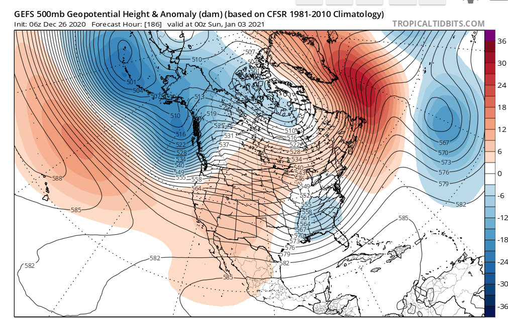
I would say watch the first few days of January for some potential. Get a ridge in the west and maybe a trough can dig on the east and then get guided up the coast as heights rise. The Atlantic side of the house promotes slowing the atmospheric flow.
This is not necessarily textbook setup, but it's all about timing. Get a ridge to pump at the right time in Idaho/MT (+PNA) area in a slowed atmosphere and then there are possibilities. We don't necessarily need the EPO to fully cooperate in January.
My take so far is if the AO can be negative for a good chunk of January then we will get our chances. The -AO is probably the most highly correlated teleconnection for the I95 receiving above average snowfall.
Last year the AO was positive to significantly positive pretty much from mid December right through the entire winter.
January 3 GEFS

heehaw453- Advanced Forecaster

- Posts : 3906
Reputation : 86
Join date : 2014-01-20
Location : Bedminster Township, PA Elevation 600' ASL
 Re: Long Range Discussion 20(20) (Ha!)
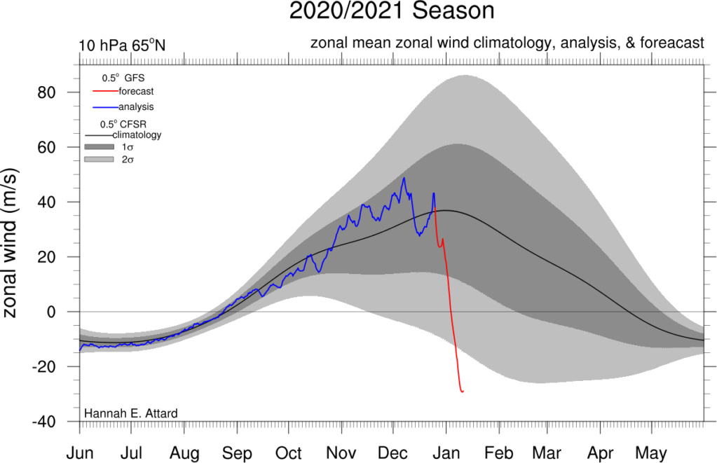
Our patience will be rewarded if the modeled sudden strat warming event comes to fruition. I have very high confidence the upper levels of the strat will see significant warming that will lead to, at the least, a displacement of the PV. Once zonal winds at the 10mb level reverse from westerly to easterly, it means warm air has successfully made its way to the upper levels. The next phase would be to see zonal wind reversals in the mid to lower levels. This normally signifies a PV split or total destruction. This is still a big question mark. However, even a PV displacement depending on where the PV gets displaced to could mean changes to our weather pattern.
https://twitter.com/simonleewx/status/1342811380374712323?s=21

https://twitter.com/simonleewx/status/1342811380374712323?s=21

_________________
_______________________________________________________________________________________________________
CLICK HERE to view NJ Strong Snowstorm Classifications
 Re: Long Range Discussion 20(20) (Ha!)
algae888 wrote:Irish wrote:algae888 wrote:Today's 12z GFS was one of the worst runs I've ever seen
Worst in regard to warm, not good setups for snow?
It has six Cutters in the next 16 days and no cold air. with the advertised pattern on the ensembles you would expect something better
Since early November, this has been the pattern.We are on the warm side of the cutters.The snowstorm we had, that pattern must have relaxed but snapped right back with the big rainstorm the other day.

docstox12- Wx Statistician Guru

- Posts : 8507
Reputation : 222
Join date : 2013-01-07
Age : 73
Location : Monroe NY
 Re: Long Range Discussion 20(20) (Ha!)
Remember this, Isotherms winter forecast pointed to Jan. to be our best/snowiest chances. It really stinks eating cutters and the pattern advertised on ENS you would think would yield better results as Algae said.
These systems are finding the kink in the chains and breaking through. NAO a bit to fear east, AO a bit to N or west, PNA ridge gets rolled over by pacific storms crashing into the west coast. Nina type pattern to a degree here.
Time will tell what will happen to the PV but an elongation would be great, you take your chances on a split and like 11-12 and last year it set up over Alaska and Siberia and we had a non winter.
_________________
Mugs
AKA:King: Snow Weenie
Self Proclaimed
WINTER 2014-15 : 55.12" +.02 for 6 coatings (avg. 35")
WINTER 2015-16 Total - 29.8" (Avg 35")
WINTER 2016-17 : 39.5" so far

amugs- Advanced Forecaster - Mod

- Posts : 15093
Reputation : 213
Join date : 2013-01-07
Age : 54
Location : Hillsdale,NJ
 Re: Long Range Discussion 20(20) (Ha!)
The PAC is the enemy right now for sure. Any time any amplification try’s to cover along the WC the next batch of energy tears it down. That’s the problem with the 28th time frame. Energy simply travels horizontally across the country. If there was any ridge amplification out west it could dig a little to our south before interacting with the northern branch.
Although it’s not likely there is a chance for 1st-3rd
Although it’s not likely there is a chance for 1st-3rd
_________________
"In weather and in life, there's no winning and losing; there's only winning and learning."
WINTER 2012/2013 TOTALS 43.65"WINTER 2017/2018 TOTALS 62.85" WINTER 2022/2023 TOTALS 4.9"
WINTER 2013/2014 TOTALS 64.85"WINTER 2018/2019 TOTALS 14.25" WINTER 2023/2024 TOTALS 13.1"
WINTER 2014/2015 TOTALS 71.20"WINTER 2019/2020 TOTALS 6.35"
WINTER 2015/2016 TOTALS 35.00"WINTER 2020/2021 TOTALS 37.75"
WINTER 2016/2017 TOTALS 42.25"WINTER 2021/2022 TOTALS 31.65"

sroc4- Admin

- Posts : 8331
Reputation : 301
Join date : 2013-01-07
Location : Wading River, LI
 Re: Long Range Discussion 20(20) (Ha!)
I can see the PAC getting better as we move deeper into January, but I don't see a sustained favorable PAC based on the long range guidance either. I believe as is usually the case that windows will appear and PNA ridge will manifest itself from time to time. Is it placed in the right spot and long enough for a short wave to take advantage of the jury will be out. I could also see threats pop up in the short/medium term within 5 days that models didn't pick up on in the long/medium term. The AO being negative will keep us in the game provided of course that it stays that way. I also don't think we need or maybe want a PV split event for reasons Mugs just stated. It can actually do a lot more harm than good to wintry prospects. I'll take my chances with what we have on the table right now...
heehaw453- Advanced Forecaster

- Posts : 3906
Reputation : 86
Join date : 2014-01-20
Location : Bedminster Township, PA Elevation 600' ASL
 Re: Long Range Discussion 20(20) (Ha!)
I know we joke around that forecasting the long range is a crap shoot, but this year I find that statement to be more accurate than any other year. Last year, our poor pattern was mostly dominated by PAC forcing/MJO. This year, the PAC continues to be an issue but the key difference is high latitude blocking on the Atlantic side. +EPO/-NAO patterns are historically precursors to major SSWEs. Our future pattern rests on how this SSWE develops and where it places the SPV.
_________________
_______________________________________________________________________________________________________
CLICK HERE to view NJ Strong Snowstorm Classifications
 Re: Long Range Discussion 20(20) (Ha!)
Well today's GFS got rid of all those Cutters and now has a lot of coastal's some that Miss and some that bring rain with the lack of cold air. As mugs stated the nao is too far Southeast but that can change as it's such a hard area to forecast. As Scott stated we still have to keep an eye on the January 1st to 3rd time frame as the models are now sending the northern peace out ahead and leaving energy behind in the southwest take a look at today's 12z ukie. Also Tom isotherm is still high on a Snowier and colder than normal January which should start after January 5th with a spike in the PNA

algae888- Advanced Forecaster

- Posts : 5311
Reputation : 46
Join date : 2013-02-05
Age : 61
Location : mt. vernon, new york
phil155 likes this post
 Re: Long Range Discussion 20(20) (Ha!)
_________________
Mugs
AKA:King: Snow Weenie
Self Proclaimed
WINTER 2014-15 : 55.12" +.02 for 6 coatings (avg. 35")
WINTER 2015-16 Total - 29.8" (Avg 35")
WINTER 2016-17 : 39.5" so far

amugs- Advanced Forecaster - Mod

- Posts : 15093
Reputation : 213
Join date : 2013-01-07
Age : 54
Location : Hillsdale,NJ

Irish- Pro Enthusiast

- Posts : 788
Reputation : 19
Join date : 2019-01-16
Age : 45
Location : Old Bridge, NJ
 Re: Long Range Discussion 20(20) (Ha!)
With a better track this would be warning level snowfall as there is a CAD with high pressure in Quebec. With WAR in place the ULL just gets shoved right through Detroit. Expect surface cold to hold on much longer than mid levels and if the precip can come in fast and hard enough then a few inches could be possible in those areas. It's also possible CAD could be stronger than currently modeled but with a track like that there are hard limits to any potential.
heehaw453- Advanced Forecaster

- Posts : 3906
Reputation : 86
Join date : 2014-01-20
Location : Bedminster Township, PA Elevation 600' ASL
amugs likes this post
Page 13 of 30 •  1 ... 8 ... 12, 13, 14 ... 21 ... 30
Page 13 of 30
Permissions in this forum:
You cannot reply to topics in this forum|
|
|

 Home
Home