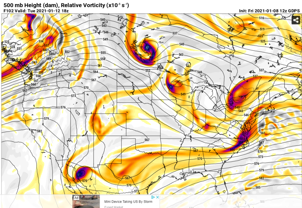
Long Range Discussion 20(20) (Ha!)
Page 21 of 30 •  1 ... 12 ... 20, 21, 22 ... 25 ... 30
 Re: Long Range Discussion 20(20) (Ha!)
crippo84 wrote:jmanley32 wrote:I am confused, this is 3 days out, wouldn't we have a good idea by now if somethere were go happen? I have not yet seen a surface run that gives us a big hit except maybe a post few pages back, is there something different about this particular possible event that makes it still interesting with no hit only 72 hrs out?sroc4 wrote:
100% Def not letting it go just yet. There is still waaay too much model to model variability with all the prev highlighted energy, as well as run to run variability within any given model. The energy I prev labeled as #1 and #2 only begins to come ashore tonight into tomorrow am respectively. Ill give this one until we are within about 72hrs. give or take. Chances still favore the miss to the south however so make sure everyone keeps expectations in check, but dont turn away just yet.
WE TRACK!!!!
Have you read all the posts about all the different pieces of energy in the atmosphere and why with the pattern we're entering any solution may not be known until a couple days in advance?
Thank You Crippo. And Jon I’ll add that I didn’t write that this am. I highlighted a key piece of the write up for you. Come on Dude.
For the record I’m still not writing it off just yet.
sroc4- Admin

- Posts : 8331
Join date : 2013-01-07
Grselig likes this post
 Re: Long Range Discussion 20(20) (Ha!)
I been super busy so no not much time to read in depth but yeah I did see the many pieces but that seems abnormal by 3 days out usually we have a pretty darn good idea of whats go happen, so only time I can think of that we did not know to throw in towel or not was before I was on here I think was boxing Day blizzard, had no idea it had done a 180 and night b4 suddenly major storm. On the alternate side we had no idea the storm that must not be named gamve me almost no snow which everyone to the east got buried. So I guess I can see how there could be a surprise but if there is a storm no one including DOT will be prepared as news says sunny and nice.sroc4 wrote:crippo84 wrote:jmanley32 wrote:I am confused, this is 3 days out, wouldn't we have a good idea by now if somethere were go happen? I have not yet seen a surface run that gives us a big hit except maybe a post few pages back, is there something different about this particular possible event that makes it still interesting with no hit only 72 hrs out?sroc4 wrote:
100% Def not letting it go just yet. There is still waaay too much model to model variability with all the prev highlighted energy, as well as run to run variability within any given model. The energy I prev labeled as #1 and #2 only begins to come ashore tonight into tomorrow am respectively. Ill give this one until we are within about 72hrs. give or take. Chances still favore the miss to the south however so make sure everyone keeps expectations in check, but dont turn away just yet.
WE TRACK!!!!
Have you read all the posts about all the different pieces of energy in the atmosphere and why with the pattern we're entering any solution may not be known until a couple days in advance?
Thank You Crippo. And Jon I’ll add that I didn’t write that this am. I highlighted a key piece of the write up for you. Come on Dude.
For the record I’m still not writing it off just yet.
jmanley32- Senior Enthusiast

- Posts : 20513
Join date : 2013-12-12
 Re: Long Range Discussion 20(20) (Ha!)

Next time frame to watch: 16th-20th
It’s going to be pretty dry for awhile...
_________________
_______________________________________________________________________________________________________
CLICK HERE to view NJ Strong Snowstorm Classifications
phil155 likes this post
phil155- Pro Enthusiast

- Posts : 475
Reputation : 4
Join date : 2019-12-16
 Re: Long Range Discussion 20(20) (Ha!)
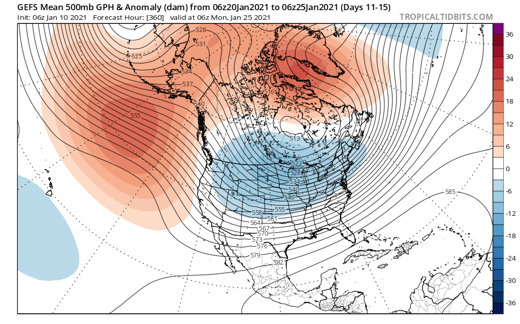
We are going to lose blocking late month into February if this comes true. There is one PNA spike around the 19th. Brutal cold will also ensue through the 25th or so. That is likely our window (19th-25th).
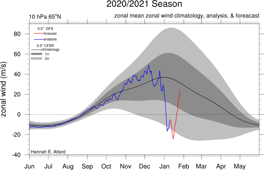
Although PNA goes negative on the GEFS, you’re still getting a source of cold from the Arctic as the EPO also goes negative. If the NAO is still negative at this time then our chances for northern stream based storms are still on the table.
_________________
_______________________________________________________________________________________________________
CLICK HERE to view NJ Strong Snowstorm Classifications
rb924119, weatherwatchermom and Sanz01 like this post
 Re: Long Range Discussion 20(20) (Ha!)
Always hear about blocking. We need blocking, there is no blocking etc. Now we have blocking, but it isn't doing anything positive. I know there is more to it than that, just frustrating.
GreyBeard- Senior Enthusiast

- Posts : 725
Reputation : 34
Join date : 2014-02-12
Location : eastern nassau county
 Re: Long Range Discussion 20(20) (Ha!)
_________________
Janet
Snowfall winter of 2023-2024 17.5"
Snowfall winter of 2022-2023 6.0"
Snowfall winter of 2021-2022 17.6" 1" sleet 2/25/22
Snowfall winter of 2020-2021 51.1"
Snowfall winter of 2019-2020 8.5"
Snowfall winter of 2018-2019 25.1"
Snowfall winter of 2017-2018 51.9"
Snowfall winter of 2016-2017 45.6"
Snowfall winter of 2015-2016 29.5"
Snowfall winter of 2014-2015 50.55"
Snowfall winter of 2013-2014 66.5"
Dunnzoo- Senior Enthusiast - Mod

- Posts : 4887
Reputation : 68
Join date : 2013-01-11
Age : 62
Location : Westwood, NJ
 Re: Long Range Discussion 20(20) (Ha!)
Why has this "epic pattern" not produced snow?
— Andrew Markowitz (@amarkowitzWX) January 11, 2021
Two factors: The -NAO has lead to suppression and kept the coldest air in the Europe. Meanwhile, the +EPO has flooded the US and Canada with warm maritime Pacific air
Late Jan, however, could be colder in the East if -EPO develops. pic.twitter.com/7MJRkioF5L
Makes great sense. We could start to see models show clippers coming through next week. Need weekend energy to dig a bit to get some widespread snow.
_________________
Mugs
AKA:King: Snow Weenie
Self Proclaimed
WINTER 2014-15 : 55.12" +.02 for 6 coatings (avg. 35")
WINTER 2015-16 Total - 29.8" (Avg 35")
WINTER 2016-17 : 39.5" so far

amugs- Advanced Forecaster - Mod

- Posts : 15093
Reputation : 213
Join date : 2013-01-07
Age : 54
Location : Hillsdale,NJ
 Re: Long Range Discussion 20(20) (Ha!)
He is correct in saying a switch from +EPO to -EPO will enable a cross-polar flow to drive colder air into the east coast. By that point, I'm not so sure we'll have an active STJ like we do not but the polar jet may be favorable for clipper-like storms to affect us.
_________________
_______________________________________________________________________________________________________
CLICK HERE to view NJ Strong Snowstorm Classifications
rb924119 likes this post
 Re: Long Range Discussion 20(20) (Ha!)
Frank_Wx wrote:I actually disagree with his characterization of the pattern. The -NAO is not in a suppressive state. It is actually conducive for east coast snowstorms. The underwhelming cold air mass has to do with the +EPO flooding the country with mild Pacific air, and also with the stratospheric warming that took place sending the SPV to the other side of the globe. If the SPV split, it would have sent a PV lobe into the lower latitudes of the Trop which would have resulted in extremely cold air entering the CONUS.
He is correct in saying a switch from +EPO to -EPO will enable a cross-polar flow to drive colder air into the east coast. By that point, I'm not so sure we'll have an active STJ like we do not but the polar jet may be favorable for clipper-like storms to affect us.
I agree with this. The PAC air caused by the +EPO air has caused many potential inches of snow to wiped off the table so far. But, even some northern stream only stuff as it gets colder (e.g., clippers) can blow up to something much bigger with the -NAO that tends to block the flow. Based on what I'm seeing now though it doesn't scream of big storm potential for the foreseeable future. I think just getting some snow OTG that sticks around would be a huge win. There's really no confidence ATTM on next time it snows around here.
heehaw453- Advanced Forecaster

- Posts : 3906
Reputation : 86
Join date : 2014-01-20
Location : Bedminster Township, PA Elevation 600' ASL
rb924119 likes this post
 Re: Long Range Discussion 20(20) (Ha!)

_________________
Mugs
AKA:King: Snow Weenie
Self Proclaimed
WINTER 2014-15 : 55.12" +.02 for 6 coatings (avg. 35")
WINTER 2015-16 Total - 29.8" (Avg 35")
WINTER 2016-17 : 39.5" so far

amugs- Advanced Forecaster - Mod

- Posts : 15093
Reputation : 213
Join date : 2013-01-07
Age : 54
Location : Hillsdale,NJ
Frank_Wx likes this post
 Re: Long Range Discussion 20(20) (Ha!)
amugs wrote:Here is what we are waiting for Nice PNA/EPO couplet = cross polar flow (or is it an arctic?) with a Negative NAO West Block - the models will start to sniff this out so be patient and have hope n faith which I know not many have in these last few winters
Verbatim, this is a fantastic pattern. It is not perfect, I would like to see a more poleward Pac ridge, but we do not need perfection in the middle of January to see it snow.
I stand by what I wrote in the scroll. The extreme high latitude blocking pattern is giving models a very difficult time. The background state of the future pattern (-EPO/-NAO) is conducive for snow. We have to be really patient and hope one of the hundred short waves coming out of the Pacific works in our favor. If we exit this pattern without seeing an inch of snow, I will shut this forum down I tell you!!!
January 18th-30th represents slightly above average snow potential
January 22nd-27th represents above average snow potential
_________________
_______________________________________________________________________________________________________
CLICK HERE to view NJ Strong Snowstorm Classifications
 Re: Long Range Discussion 20(20) (Ha!)
p.s. he also was very bullish on the possibility of an unusually snowy pattern in the United Kingdom for the UK members on this Forum.

billg315- Advanced Forecaster - Mod

- Posts : 4462
Reputation : 185
Join date : 2015-01-24
Age : 50
Location : Flemington, NJ
Grselig and brownie like this post
 Re: Long Range Discussion 20(20) (Ha!)
mwilli- Posts : 132
Reputation : 3
Join date : 2019-02-11
 Re: Long Range Discussion 20(20) (Ha!)

dkodgis- Senior Enthusiast

- Posts : 2494
Reputation : 98
Join date : 2013-12-29
 Re: Long Range Discussion 20(20) (Ha!)
As Frank has stated after mid month things may get jiggy and possibly extreme for some regions of the US. Even Rb said after Jan 20th he sees more implications of possibly wintry events.
The potential storms that I outlined -(2/3, 12,16,23) were squashed or shredded by the NAO and the PAC JET.
Lots of winter left and we have had many winters where we did not get started until mid to late Jan. Patience here as always.
JB has made some great calls in his day and missed on some as well but that the fun of predicting especially weather. He is a very intelligent meteorologist - read both his books.
Just a bit to far N!
Here the 16/17th storm - could be an appy for our Northern Posters

_________________
Mugs
AKA:King: Snow Weenie
Self Proclaimed
WINTER 2014-15 : 55.12" +.02 for 6 coatings (avg. 35")
WINTER 2015-16 Total - 29.8" (Avg 35")
WINTER 2016-17 : 39.5" so far

amugs- Advanced Forecaster - Mod

- Posts : 15093
Reputation : 213
Join date : 2013-01-07
Age : 54
Location : Hillsdale,NJ
 Re: Long Range Discussion 20(20) (Ha!)
I'd really like to see some good faith snow from the -AO/-NAO fairly soon.
Last edited by heehaw453 on Wed Jan 13, 2021 2:27 pm; edited 1 time in total
heehaw453- Advanced Forecaster

- Posts : 3906
Reputation : 86
Join date : 2014-01-20
Location : Bedminster Township, PA Elevation 600' ASL
 Re: Long Range Discussion 20(20) (Ha!)

_________________
Mugs
AKA:King: Snow Weenie
Self Proclaimed
WINTER 2014-15 : 55.12" +.02 for 6 coatings (avg. 35")
WINTER 2015-16 Total - 29.8" (Avg 35")
WINTER 2016-17 : 39.5" so far

amugs- Advanced Forecaster - Mod

- Posts : 15093
Reputation : 213
Join date : 2013-01-07
Age : 54
Location : Hillsdale,NJ
 Re: Long Range Discussion 20(20) (Ha!)
heehaw453 wrote:Some guidance including today's 12Z Euro shows a threat around 1/21. SWFE kind of deal with a nice baroclinic zone to our south. IMO with the blocking occurring that is a more plausible way to get some decent snow here without help from the PAC. A weaker wave riding along the baroclinic zone can produce here quite nicely.
I'd really like to see some good faith snow from the -AO/-NAO fairly soon.
Def looks all nice. HP to the noprth in great position as it approaches. Very cold air mass in place. Surface temps in upper 20's low 30's with dewpoints in mid twenties. Mid levels -3 to -6*c. Id say verbatim its probably a 12-15:1 ratio to whatever QPF fell. With likely baroclinic enhancements to the totals models tend to miss.
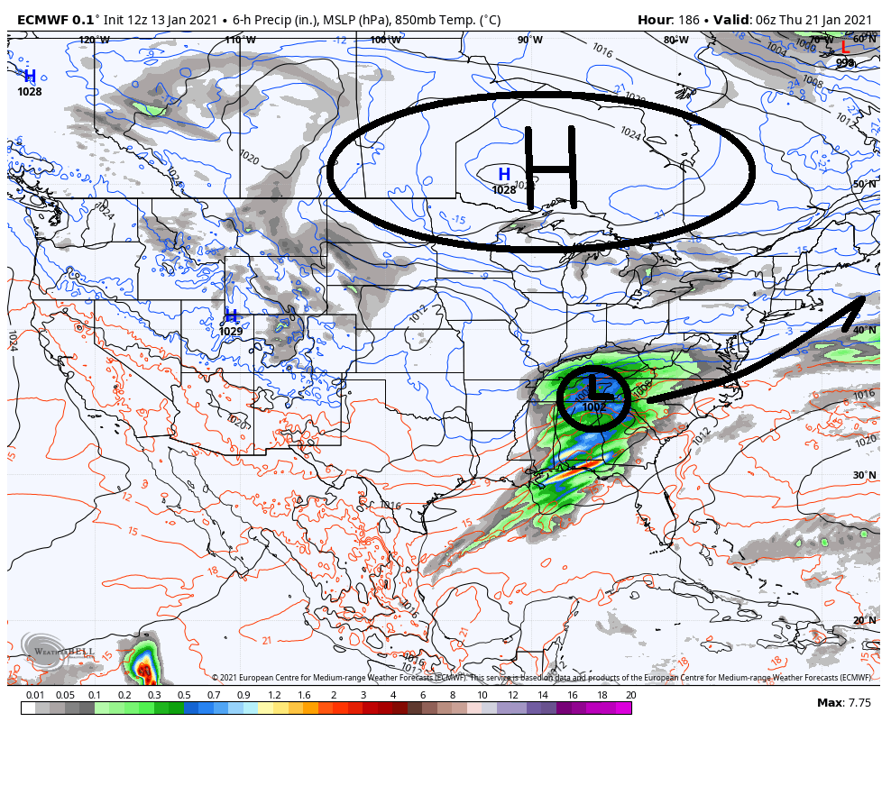
BUUUTTTT its 7-8 days out so......

We'll keep an eye on it. Im not trying to be a jerk. Just frustrated...me want snow!
_________________
"In weather and in life, there's no winning and losing; there's only winning and learning."
WINTER 2012/2013 TOTALS 43.65"WINTER 2017/2018 TOTALS 62.85" WINTER 2022/2023 TOTALS 4.9"
WINTER 2013/2014 TOTALS 64.85"WINTER 2018/2019 TOTALS 14.25" WINTER 2023/2024 TOTALS 13.1"
WINTER 2014/2015 TOTALS 71.20"WINTER 2019/2020 TOTALS 6.35"
WINTER 2015/2016 TOTALS 35.00"WINTER 2020/2021 TOTALS 37.75"
WINTER 2016/2017 TOTALS 42.25"WINTER 2021/2022 TOTALS 31.65"

sroc4- Admin

- Posts : 8331
Reputation : 301
Join date : 2013-01-07
Location : Wading River, LI
crippo84 likes this post
 Re: Long Range Discussion 20(20) (Ha!)
amugs wrote:It coming folks and teh ENS are picking up on it, it will evolve.
As Frank has stated after mid month things may get jiggy and possibly extreme for some regions of the US. Even Rb said after Jan 20th he sees more implications of possibly wintry events.
The potential storms that I outlined -(2/3, 12,16,23) were squashed or shredded by the NAO and the PAC JET.
Lots of winter left and we have had many winters where we did not get started until mid to late Jan. Patience here as always.
JB has made some great calls in his day and missed on some as well but that the fun of predicting especially weather. He is a very intelligent meteorologist - read both his books.
Just a bit to far N!
Here the 16/17th storm - could be an appy for our Northern Posters
No offense, mugsy, but I never said that haha I said the 14th-16th threat would be the best chance at getting snow to the coast before we began to see an increasingly hostile pattern evolve (or the “better” pattern devolve, though I argued that it wasn’t really that much better, and that even the 14th-16th threat would most likely favor the interior (I-81 Corridor)) for coastal snow. My lack of posting should indicate that my feelings remain generally unchanged lol
rb924119- Meteorologist

- Posts : 6889
Reputation : 194
Join date : 2013-02-06
Age : 32
Location : Greentown, Pa
chief7 likes this post
 Re: Long Range Discussion 20(20) (Ha!)
chief7- Posts : 132
Reputation : 0
Join date : 2013-11-10
Location : Langhorne pa
 Re: Long Range Discussion 20(20) (Ha!)
A weak wave riding the baroclinic zone will give us best chance to stay snow and produce a moderate to possibly significant event.
An amplified storm will run the risk of further west track which will put us at risk for frozen other than snow. However, there still may be light/moderate front end snow in that scenario.
The upshot is there is a threat next week. Do not underestimate the -NAO in this scenario as well. Models often underappreciate its effects.
heehaw453- Advanced Forecaster

- Posts : 3906
Reputation : 86
Join date : 2014-01-20
Location : Bedminster Township, PA Elevation 600' ASL
 Re: Long Range Discussion 20(20) (Ha!)
heehaw453 wrote:Obviously at 7 days out lots can change but guidance is consistent on bringing the moisture far enough north. Not really seeing this getting suppressed based on what I've been seeing. The air will probably be plenty of cold at all levels to support snow at least to start.
A weak wave riding the baroclinic zone will give us best chance to stay snow and produce a moderate to possibly significant event.
An amplified storm will run the risk of further west track which will put us at risk for frozen other than snow. However, there still may be light/moderate front end snow in that scenario.
The upshot is there is a threat next week. Do not underestimate the -NAO in this scenario as well. Models often underappreciate its effects.
GFS seems to favor a couple opportunities for the setup you describe, one around the 23rd and another around the 26th. Still a ways out but I think it could at a minimum be hinting that this is the type of pattern that will set up once this colder air settles in middle of next week. We do often get locked into a certain storm track/pattern this time of year so it would make sense if we had a few opportunities for these types of waves in the coming weeks. I do get concerned with these that it's tightrope walk: too much cold air and we get suppression while the folks in Maryland and the Delmarva enjoy their snow, not enough cold air and we get a changeover to slop.

billg315- Advanced Forecaster - Mod

- Posts : 4462
Reputation : 185
Join date : 2015-01-24
Age : 50
Location : Flemington, NJ
 Re: Long Range Discussion 20(20) (Ha!)
As shown in our paper: https://t.co/1MjGyAOGVF the risk of severe #winter weather is greatly increased when low to mid-troposphere Polar Cap geopotential Heights (PCHs) spike as predicted by GFS in late January. This is the period to watch in Northeast US, Europe & Northern Asia. pic.twitter.com/bjQchm87df
— Judah Cohen (@judah47) January 14, 2021
_________________
Mugs
AKA:King: Snow Weenie
Self Proclaimed
WINTER 2014-15 : 55.12" +.02 for 6 coatings (avg. 35")
WINTER 2015-16 Total - 29.8" (Avg 35")
WINTER 2016-17 : 39.5" so far

amugs- Advanced Forecaster - Mod

- Posts : 15093
Reputation : 213
Join date : 2013-01-07
Age : 54
Location : Hillsdale,NJ
 Re: Long Range Discussion 20(20) (Ha!)
Negative pna which enhances the ridge
Negative nao
Negative ao
Negative EPO which drives the cold into our area

Snow88- Senior Enthusiast

- Posts : 2193
Reputation : 4
Join date : 2013-01-09
Age : 35
Location : Brooklyn, NY
amugs likes this post
 Re: Long Range Discussion 20(20) (Ha!)
mwilli- Posts : 132
Reputation : 3
Join date : 2019-02-11
 Re: Long Range Discussion 20(20) (Ha!)

algae888- Advanced Forecaster

- Posts : 5311
Reputation : 46
Join date : 2013-02-05
Age : 61
Location : mt. vernon, new york
Page 21 of 30 •  1 ... 12 ... 20, 21, 22 ... 25 ... 30
|
|
|

 Home
Home