Long Range Discussion 20(20) (Ha!)
+43
toople
TheAresian
Koroptim
Bkdude
essexcountypete
chief7
GreyBeard
crippo84
hyde345
lglickman1
Zhukov1945
bloc1357
SENJsnowman
Snow88
CPcantmeasuresnow
bobjohnsonforthehall
weatherwatchermom
skinsfan1177
billg315
SoulSingMG
phil155
aiannone
nutleyblizzard
Math23x7
Wheezer
Irish
Frank_Wx
mwilli
Grselig
Isotherm
heehaw453
jimv45
frank 638
docstox12
rb924119
sroc4
HectorO
algae888
dkodgis
Radz
jmanley32
amugs
Dunnzoo
47 posters
Page 23 of 30
Page 23 of 30 •  1 ... 13 ... 22, 23, 24 ... 26 ... 30
 Re: Long Range Discussion 20(20) (Ha!)
12Z Euro continues to put out just < 1" of liquid. It moved it toward DC and Baltimore this run. It's looking less likely the ULL making it to Michigan and more likely it stays under us. The question becomes how far does the ULL get because it does have Atlantic Ocean moisture that it's connected to at the 700 mb. This tells me if you're in the right spot then significant snow is on the table. Expect this to bounce around but the key in my mind is how does the TPV affect this?

heehaw453- Advanced Forecaster

- Posts : 3906
Join date : 2014-01-20
 Re: Long Range Discussion 20(20) (Ha!)
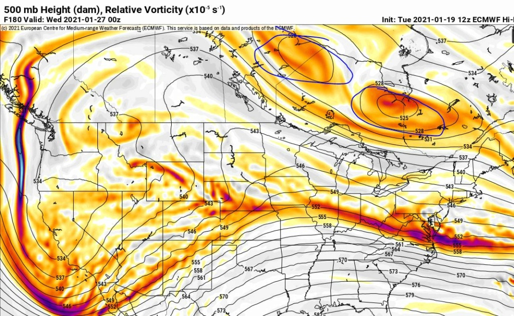
Look at that east to west vortices, my God.
Overrunning event.
Overrunning event.
amugs- Advanced Forecaster - Mod

- Posts : 15093
Join date : 2013-01-07
 Re: Long Range Discussion 20(20) (Ha!)
Next weeks system is in pretty good position right now. Todays 12z GFS is Momma bear, and the Canadian is Baby Bear. Lets see where Euro comes in.
_________________
"In weather and in life, there's no winning and losing; there's only winning and learning."
WINTER 2012/2013 TOTALS 43.65"WINTER 2017/2018 TOTALS 62.85" WINTER 2022/2023 TOTALS 4.9"
WINTER 2013/2014 TOTALS 64.85"WINTER 2018/2019 TOTALS 14.25" WINTER 2023/2024 TOTALS 13.1"
WINTER 2014/2015 TOTALS 71.20"WINTER 2019/2020 TOTALS 6.35"
WINTER 2015/2016 TOTALS 35.00"WINTER 2020/2021 TOTALS 37.75"
WINTER 2016/2017 TOTALS 42.25"WINTER 2021/2022 TOTALS 31.65"

sroc4- Admin

- Posts : 8331
Reputation : 301
Join date : 2013-01-07
Location : Wading River, LI
 Re: Long Range Discussion 20(20) (Ha!)
sroc4 wrote:Next weeks system is in pretty good position right now. Todays 12z GFS is Momma bear, and the Canadian is Baby Bear. Lets see where Euro comes in.
6z euro ens took the low to Pittsburgh big jump north. We also have today's ukie and icon north. Not getting too invested until Friday 12Z

algae888- Advanced Forecaster

- Posts : 5311
Reputation : 46
Join date : 2013-02-05
Age : 61
Location : mt. vernon, new york
 Re: Long Range Discussion 20(20) (Ha!)
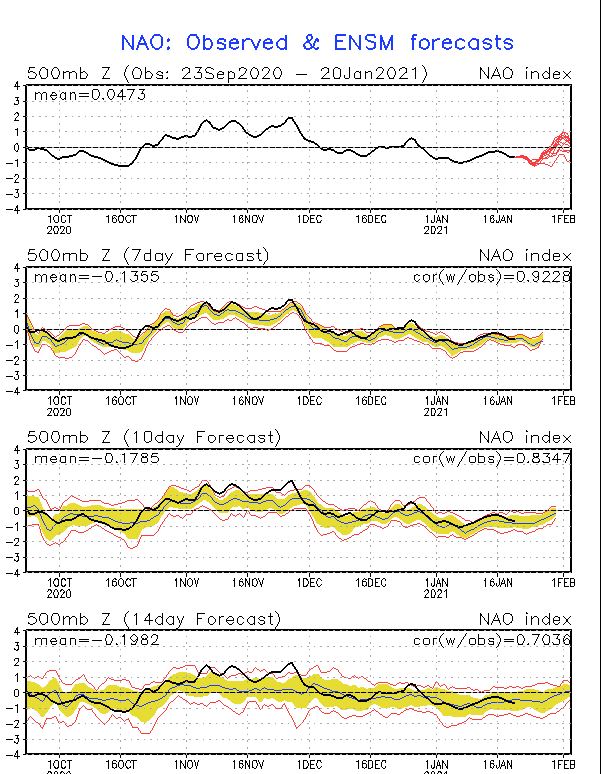
A very unique pattern a negative 1.5 SD Arctic oscillation negative 1.5 SD PNA. One suppresses systems so they only get so far North the other one pumps the Southeast ridge interesting how this will play out next week

algae888- Advanced Forecaster

- Posts : 5311
Reputation : 46
Join date : 2013-02-05
Age : 61
Location : mt. vernon, new york
 Re: Long Range Discussion 20(20) (Ha!)
algae888 wrote:A very unique pattern a negative 1.5 SD Arctic oscillation negative 1.5 SD PNA. One suppresses systems so they only get so far North the other one pumps the Southeast ridge interesting how this will play out next week
Dont forget the -2 STD to the -NAO too
_________________
"In weather and in life, there's no winning and losing; there's only winning and learning."
WINTER 2012/2013 TOTALS 43.65"WINTER 2017/2018 TOTALS 62.85" WINTER 2022/2023 TOTALS 4.9"
WINTER 2013/2014 TOTALS 64.85"WINTER 2018/2019 TOTALS 14.25" WINTER 2023/2024 TOTALS 13.1"
WINTER 2014/2015 TOTALS 71.20"WINTER 2019/2020 TOTALS 6.35"
WINTER 2015/2016 TOTALS 35.00"WINTER 2020/2021 TOTALS 37.75"
WINTER 2016/2017 TOTALS 42.25"WINTER 2021/2022 TOTALS 31.65"

sroc4- Admin

- Posts : 8331
Reputation : 301
Join date : 2013-01-07
Location : Wading River, LI
 Re: Long Range Discussion 20(20) (Ha!)
Changes with the ridge axis of the PNA and NAO
From John Homenuk (AKA earthlight)
Comparing this 12z Euro run to the 00z run valid 15z Saturday, there is considerably less interaction with the TPV over Southern Canada. This should allow for more amplification of the mid level height field down the road.
From John Homenuk (AKA earthlight)
Comparing this 12z Euro run to the 00z run valid 15z Saturday, there is considerably less interaction with the TPV over Southern Canada. This should allow for more amplification of the mid level height field down the road.
_________________
Mugs
AKA:King: Snow Weenie
Self Proclaimed
WINTER 2014-15 : 55.12" +.02 for 6 coatings (avg. 35")
WINTER 2015-16 Total - 29.8" (Avg 35")
WINTER 2016-17 : 39.5" so far

amugs- Advanced Forecaster - Mod

- Posts : 15093
Reputation : 213
Join date : 2013-01-07
Age : 54
Location : Hillsdale,NJ
 Re: Long Range Discussion 20(20) (Ha!)
Euro area wide mild-moderate event. Still too far out to get excited but encoraging
_________________
"In weather and in life, there's no winning and losing; there's only winning and learning."
WINTER 2012/2013 TOTALS 43.65"WINTER 2017/2018 TOTALS 62.85" WINTER 2022/2023 TOTALS 4.9"
WINTER 2013/2014 TOTALS 64.85"WINTER 2018/2019 TOTALS 14.25" WINTER 2023/2024 TOTALS 13.1"
WINTER 2014/2015 TOTALS 71.20"WINTER 2019/2020 TOTALS 6.35"
WINTER 2015/2016 TOTALS 35.00"WINTER 2020/2021 TOTALS 37.75"
WINTER 2016/2017 TOTALS 42.25"WINTER 2021/2022 TOTALS 31.65"

sroc4- Admin

- Posts : 8331
Reputation : 301
Join date : 2013-01-07
Location : Wading River, LI
 Re: Long Range Discussion 20(20) (Ha!)
The event has potential to be significant 5+". There is good Atlantic Ocean moisture fetch and the wave on many models is vigorous. I would probably err on the side of moderate for now until we understand better how the primary low tracks. My feeling is though that the TPV will keep primary ULL from getting past West Virginia.
I'm going to continue to harp on the fact the antecedent air mass this time is not garbage, but good. That matters big time.
Low 2 m dew points allows for a nice overrunning surface.
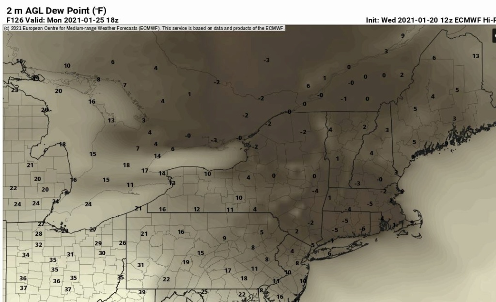
I'm going to continue to harp on the fact the antecedent air mass this time is not garbage, but good. That matters big time.
Low 2 m dew points allows for a nice overrunning surface.

heehaw453- Advanced Forecaster

- Posts : 3906
Reputation : 86
Join date : 2014-01-20
Location : Bedminster Township, PA Elevation 600' ASL
heehaw453- Advanced Forecaster

- Posts : 3906
Reputation : 86
Join date : 2014-01-20
Location : Bedminster Township, PA Elevation 600' ASL
 Re: Long Range Discussion 20(20) (Ha!)
Well we're now down to 5 days and the potential is still there for a decent event so that is a plus. This energy comes ashore Friday so hopefully the modeling should start zeroing in on details a little better by then. Still hanging in that pool of cautious optimism for now. 

billg315- Advanced Forecaster - Mod

- Posts : 4469
Reputation : 185
Join date : 2015-01-24
Age : 50
Location : Flemington, NJ
sroc4 likes this post
 Re: Long Range Discussion 20(20) (Ha!)
EPS Cluster farther N for sure - good sign

Runs to Dayton then gets pushed underneath - thank you Mr. NAO


Runs to Dayton then gets pushed underneath - thank you Mr. NAO

_________________
Mugs
AKA:King: Snow Weenie
Self Proclaimed
WINTER 2014-15 : 55.12" +.02 for 6 coatings (avg. 35")
WINTER 2015-16 Total - 29.8" (Avg 35")
WINTER 2016-17 : 39.5" so far

amugs- Advanced Forecaster - Mod

- Posts : 15093
Reputation : 213
Join date : 2013-01-07
Age : 54
Location : Hillsdale,NJ
 Re: Long Range Discussion 20(20) (Ha!)
Is there a storm thread for the storm next week ?

Snow88- Senior Enthusiast

- Posts : 2193
Reputation : 4
Join date : 2013-01-09
Age : 35
Location : Brooklyn, NY
 Re: Long Range Discussion 20(20) (Ha!)
Not yet we'll wait until tomorrow 72 hour range before we go tony.Snow88 wrote:Is there a storm thread for the storm next week ?
From Sir Walter Draq - pro met
My impression: Travelers into the northeast USA Monday-Tuesday the 25th-26th: Still considerable uncertainty on how this all transpires but we should be aware that an extensive hazardous wintry episode is expected for all untreated surfaces, especially the I84-I80-I95 corridors from Baltimore to I80, with less certainty I84. The front end Monday start time is uncertain. It could start for a couple of hours Monday morning then stop for 12 hours. The bulk of this event probably occurs Monday night into Tuesday the 26th. Odds favor a change to rain or ice along the I95 corridor Tuesday morning the 26th, but mostly snow northwest of I95, especially the I80 corridor northward. There is considerable uncertainty on where the primary snow or ice event will occur in the northeast so its good to be aware of the possibilities but no action recommended yet, unless you're headed to Baltimore-Philly where messy slippery wintry elements develop by Noon Monday. Have a day!
_________________
Mugs
AKA:King: Snow Weenie
Self Proclaimed
WINTER 2014-15 : 55.12" +.02 for 6 coatings (avg. 35")
WINTER 2015-16 Total - 29.8" (Avg 35")
WINTER 2016-17 : 39.5" so far

amugs- Advanced Forecaster - Mod

- Posts : 15093
Reputation : 213
Join date : 2013-01-07
Age : 54
Location : Hillsdale,NJ
 Re: Long Range Discussion 20(20) (Ha!)
Three storm chances over the Monday to Monday/Tuesday period
_________________
Mugs
AKA:King: Snow Weenie
Self Proclaimed
WINTER 2014-15 : 55.12" +.02 for 6 coatings (avg. 35")
WINTER 2015-16 Total - 29.8" (Avg 35")
WINTER 2016-17 : 39.5" so far

amugs- Advanced Forecaster - Mod

- Posts : 15093
Reputation : 213
Join date : 2013-01-07
Age : 54
Location : Hillsdale,NJ
 Re: Long Range Discussion 20(20) (Ha!)
If today's 12z runs keep the 26th interesting we will start a storm thread.
The EURO/UKIE in particular are important because they are the ones hitting the area hard with measurable snowfall.
These gradient type storms have a tendency to drop significant snowfall for a small section of the area. Whoever is on the cold side, or just north of the baroclinic zone, is going to see heavy snowfall rates. The upper level vorticity is squeezed through the High to the north and SE ridge, which calls for feisty low pressure system. The key is making sure this low pressure system gets far enough north. Some models keep it way to our south because there is a TPV in southern Canada trying to suppress heights.
As stated in my post last week, the -NAO/-EPO - regardless whether it's 'real' or pseudo-like - are enough to consolidate the upper energy in the mid-section of the CONUS. Just enough cold air to keep things interesting
_________________
_______________________________________________________________________________________________________
CLICK HERE to view NJ Strong Snowstorm Classifications
 Re: Long Range Discussion 20(20) (Ha!)
Frank_Wx wrote:If today's 12z runs keep the 26th interesting we will start a storm thread.
The EURO/UKIE in particular are important because they are the ones hitting the area hard with measurable snowfall.
These gradient type storms have a tendency to drop significant snowfall for a small section of the area. Whoever is on the cold side, or just north of the baroclinic zone, is going to see heavy snowfall rates. The upper level vorticity is squeezed through the High to the north and SE ridge, which calls for feisty low pressure system. The key is making sure this low pressure system gets far enough north. Some models keep it way to our south because there is a TPV in southern Canada trying to suppress heights.
As stated in my post last week, the -NAO/-EPO - regardless whether it's 'real' or pseudo-like - are enough to consolidate the upper energy in the mid-section of the CONUS. Just enough cold air to keep things interesting
TWC is calling for 2-6 inches Monday night into Tuesday. That total is upticked from yesterday's forecast of 1-3.

Irish- Pro Enthusiast

- Posts : 788
Reputation : 19
Join date : 2019-01-16
Age : 45
Location : Old Bridge, NJ
 Re: Long Range Discussion 20(20) (Ha!)
28/29th comes out of the Gulf States with a NAO block in place could be interesting for another storm that could be a light to more moderate snow. Interesting. GFS


_________________
Mugs
AKA:King: Snow Weenie
Self Proclaimed
WINTER 2014-15 : 55.12" +.02 for 6 coatings (avg. 35")
WINTER 2015-16 Total - 29.8" (Avg 35")
WINTER 2016-17 : 39.5" so far

amugs- Advanced Forecaster - Mod

- Posts : 15093
Reputation : 213
Join date : 2013-01-07
Age : 54
Location : Hillsdale,NJ
 Re: Long Range Discussion 20(20) (Ha!)
amugs wrote:Not yet we'll wait until tomorrow 72 hour range before we go tony.Snow88 wrote:Is there a storm thread for the storm next week ?
From Sir Walter Draq - pro met
My impression: Travelers into the northeast USA Monday-Tuesday the 25th-26th: Still considerable uncertainty on how this all transpires but we should be aware that an extensive hazardous wintry episode is expected for all untreated surfaces, especially the I84-I80-I95 corridors from Baltimore to I80, with less certainty I84. The front end Monday start time is uncertain. It could start for a couple of hours Monday morning then stop for 12 hours. The bulk of this event probably occurs Monday night into Tuesday the 26th. Odds favor a change to rain or ice along the I95 corridor Tuesday morning the 26th, but mostly snow northwest of I95, especially the I80 corridor northward. There is considerable uncertainty on where the primary snow or ice event will occur in the northeast so its good to be aware of the possibilities but no action recommended yet, unless you're headed to Baltimore-Philly where messy slippery wintry elements develop by Noon Monday. Have a day!
Persoanllly I dont think odds favor a changeover for the locations stated at all. Not to say it doesnt happen though. Odds favor miss to the south or an all snow event IMHO of course. I love where we sit right now. The fact that the GFS has remained to the south is a good thing at this lead time. Its only a very minor 500mb adjustment away from a nice mod event. CMC shows what this adjustment would be nicely.
_________________
"In weather and in life, there's no winning and losing; there's only winning and learning."
WINTER 2012/2013 TOTALS 43.65"WINTER 2017/2018 TOTALS 62.85" WINTER 2022/2023 TOTALS 4.9"
WINTER 2013/2014 TOTALS 64.85"WINTER 2018/2019 TOTALS 14.25" WINTER 2023/2024 TOTALS 13.1"
WINTER 2014/2015 TOTALS 71.20"WINTER 2019/2020 TOTALS 6.35"
WINTER 2015/2016 TOTALS 35.00"WINTER 2020/2021 TOTALS 37.75"
WINTER 2016/2017 TOTALS 42.25"WINTER 2021/2022 TOTALS 31.65"

sroc4- Admin

- Posts : 8331
Reputation : 301
Join date : 2013-01-07
Location : Wading River, LI
 Re: Long Range Discussion 20(20) (Ha!)
sroc4 wrote:amugs wrote:Not yet we'll wait until tomorrow 72 hour range before we go tony.Snow88 wrote:Is there a storm thread for the storm next week ?
From Sir Walter Draq - pro met
My impression: Travelers into the northeast USA Monday-Tuesday the 25th-26th: Still considerable uncertainty on how this all transpires but we should be aware that an extensive hazardous wintry episode is expected for all untreated surfaces, especially the I84-I80-I95 corridors from Baltimore to I80, with less certainty I84. The front end Monday start time is uncertain. It could start for a couple of hours Monday morning then stop for 12 hours. The bulk of this event probably occurs Monday night into Tuesday the 26th. Odds favor a change to rain or ice along the I95 corridor Tuesday morning the 26th, but mostly snow northwest of I95, especially the I80 corridor northward. There is considerable uncertainty on where the primary snow or ice event will occur in the northeast so its good to be aware of the possibilities but no action recommended yet, unless you're headed to Baltimore-Philly where messy slippery wintry elements develop by Noon Monday. Have a day!
Persoanllly I dont think odds favor a changeover for the locations stated at all. Not to say it doesnt happen though. Odds favor miss to the south or an all snow event IMHO of course. I love where we sit right now. The fact that the GFS has remained to the south is a good thing at this lead time. Its only a very minor 500mb adjustment away from a nice mod event. CMC shows what this adjustment would be nicely.
Any visual proof of said CMC run for us weather disabled folk?

Irish- Pro Enthusiast

- Posts : 788
Reputation : 19
Join date : 2019-01-16
Age : 45
Location : Old Bridge, NJ
 Re: Long Range Discussion 20(20) (Ha!)
Irish wrote:sroc4 wrote:amugs wrote:Not yet we'll wait until tomorrow 72 hour range before we go tony.Snow88 wrote:Is there a storm thread for the storm next week ?
From Sir Walter Draq - pro met
My impression: Travelers into the northeast USA Monday-Tuesday the 25th-26th: Still considerable uncertainty on how this all transpires but we should be aware that an extensive hazardous wintry episode is expected for all untreated surfaces, especially the I84-I80-I95 corridors from Baltimore to I80, with less certainty I84. The front end Monday start time is uncertain. It could start for a couple of hours Monday morning then stop for 12 hours. The bulk of this event probably occurs Monday night into Tuesday the 26th. Odds favor a change to rain or ice along the I95 corridor Tuesday morning the 26th, but mostly snow northwest of I95, especially the I80 corridor northward. There is considerable uncertainty on where the primary snow or ice event will occur in the northeast so its good to be aware of the possibilities but no action recommended yet, unless you're headed to Baltimore-Philly where messy slippery wintry elements develop by Noon Monday. Have a day!
Persoanllly I dont think odds favor a changeover for the locations stated at all. Not to say it doesnt happen though. Odds favor miss to the south or an all snow event IMHO of course. I love where we sit right now. The fact that the GFS has remained to the south is a good thing at this lead time. Its only a very minor 500mb adjustment away from a nice mod event. CMC shows what this adjustment would be nicely.
Any visual proof of said CMC run for us weather disabled folk?
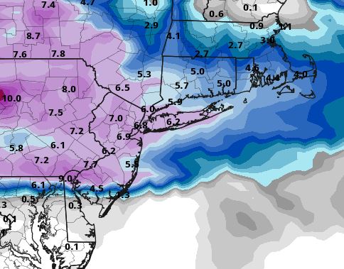
This is plausible outcome IMO. But everything is still on the table right now from suppressed solution to a changeover. I favor against this getting too far north ATTM to bring the surface above freezing, but mid-levels are always a concern as we don't have a strong high pumping in cold air situated to our north.
I would set expectations like the Frank's scroll has them for now... but realize we can exceed expectations if things go right.
12Z Canadian
heehaw453- Advanced Forecaster

- Posts : 3906
Reputation : 86
Join date : 2014-01-20
Location : Bedminster Township, PA Elevation 600' ASL
Irish likes this post
 Re: Long Range Discussion 20(20) (Ha!)
12Z Euro is a very respectable 4-6" for 1/25-1/26 and very interesting potential for 1/28.
This is 1/28 500mb vorticity. Notice the negative tilt to the trough with decent back side ridging as well as tremendous energy on the trough base. Verbatim it'd probably blow up a good storm with that look off the coast. Interesting to say the least. That could be a blizzard for some lucky folks...
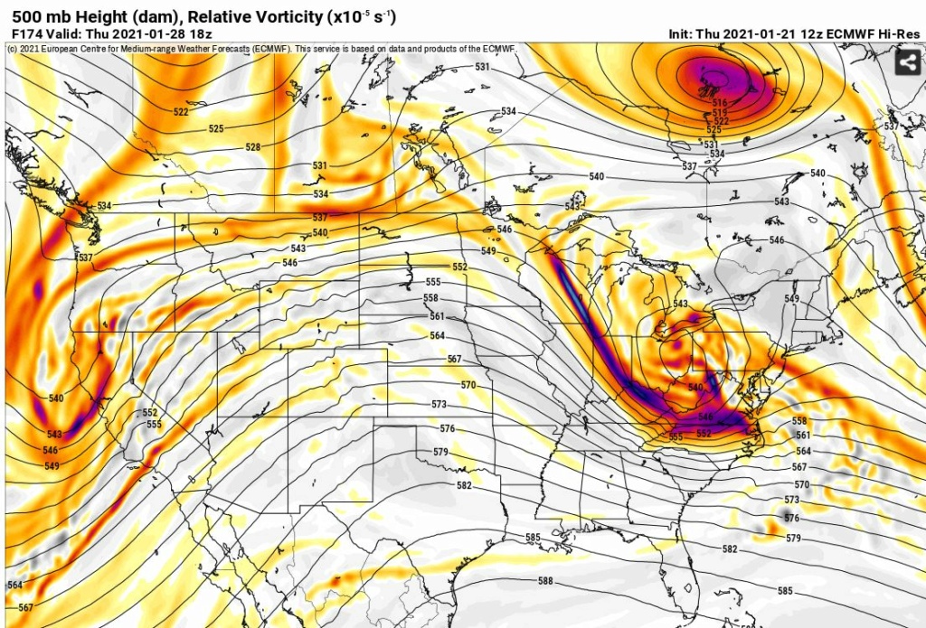
This is 1/28 500mb vorticity. Notice the negative tilt to the trough with decent back side ridging as well as tremendous energy on the trough base. Verbatim it'd probably blow up a good storm with that look off the coast. Interesting to say the least. That could be a blizzard for some lucky folks...

heehaw453- Advanced Forecaster

- Posts : 3906
Reputation : 86
Join date : 2014-01-20
Location : Bedminster Township, PA Elevation 600' ASL
 Re: Long Range Discussion 20(20) (Ha!)
heehaw453 wrote:12Z Euro is a very respectable 4-6" for 1/25-1/26 and very interesting potential for 1/28.
This is 1/28 500mb vorticity. Notice the negative tilt to the trough with decent back side ridging as well as tremendous energy on the trough base. Verbatim it'd probably blow up a good storm with that look off the coast. Interesting to say the least. That could be a blizzard for some lucky folks...
I did notice on the euro there was a little bit of a subsidence issue over the area, esp eastern portions, as the energy into the Ohio valley begins to turn ESE at 500. If anyone looked at the surface precip maps as it approached and though ok here we go, only to watch some of the precip seem to fizzle out thats why. As depicted verbatim the euro snow fall ratio's would def be higher than 10:1 even along the coast with surface temps in the upper 20's, dew points in the low 20's and mid levels remaining between -2 and -6* Celsius. Likely need to get to the 12z runs on Sat to really hone in on the details though.
We track!!!

_________________
"In weather and in life, there's no winning and losing; there's only winning and learning."
WINTER 2012/2013 TOTALS 43.65"WINTER 2017/2018 TOTALS 62.85" WINTER 2022/2023 TOTALS 4.9"
WINTER 2013/2014 TOTALS 64.85"WINTER 2018/2019 TOTALS 14.25" WINTER 2023/2024 TOTALS 13.1"
WINTER 2014/2015 TOTALS 71.20"WINTER 2019/2020 TOTALS 6.35"
WINTER 2015/2016 TOTALS 35.00"WINTER 2020/2021 TOTALS 37.75"
WINTER 2016/2017 TOTALS 42.25"WINTER 2021/2022 TOTALS 31.65"

sroc4- Admin

- Posts : 8331
Reputation : 301
Join date : 2013-01-07
Location : Wading River, LI
 Re: Long Range Discussion 20(20) (Ha!)
Just waiting for rb to come in here and share his 2 cents on things for the next week or so. Hoping it's not doom and gloom...

Irish- Pro Enthusiast

- Posts : 788
Reputation : 19
Join date : 2019-01-16
Age : 45
Location : Old Bridge, NJ
 Re: Long Range Discussion 20(20) (Ha!)
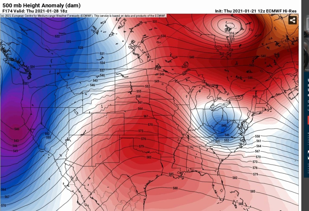
Might need to pump the heights up a little more off the coast to turn that thing north on Thursday (1/28) no? With the first storm sliding off the coast just a couple days before, does that create/keep the upper air progression too "flat" along the coast for the Thursday storm to get far enough north for a major event here?

billg315- Advanced Forecaster - Mod

- Posts : 4469
Reputation : 185
Join date : 2015-01-24
Age : 50
Location : Flemington, NJ
 Re: Long Range Discussion 20(20) (Ha!)
billg315 wrote:Might need to pump the heights up a little more off the coast to turn that thing north on Thursday (1/28) no? With the first storm sliding off the coast just a couple days before, does that create/keep the upper air progression too "flat" along the coast for the Thursday storm to get far enough north for a major event here?
I think the ridging out west determines the fate of this potential. If you put this ridge in plains 100 miles west then this storm has more room to come up as the trough would have more time to go negative and rise the heights on the EC. Even as it stands as shown anyone NYC south would probably get something from this verbatim. It's hard not to be intrigued at this even if it misses us...
heehaw453- Advanced Forecaster

- Posts : 3906
Reputation : 86
Join date : 2014-01-20
Location : Bedminster Township, PA Elevation 600' ASL
 Re: Long Range Discussion 20(20) (Ha!)
_________________
Mugs
AKA:King: Snow Weenie
Self Proclaimed
WINTER 2014-15 : 55.12" +.02 for 6 coatings (avg. 35")
WINTER 2015-16 Total - 29.8" (Avg 35")
WINTER 2016-17 : 39.5" so far

amugs- Advanced Forecaster - Mod

- Posts : 15093
Reputation : 213
Join date : 2013-01-07
Age : 54
Location : Hillsdale,NJ
SENJsnowman likes this post
Page 23 of 30 •  1 ... 13 ... 22, 23, 24 ... 26 ... 30
Page 23 of 30
Permissions in this forum:
You cannot reply to topics in this forum|
|
|

 Home
Home