DECEMBER 16th 17th 2020 Snow Threat???
+39
SNOW MAN
snowday111
MattyICE
Nyi1058
dsix85
SENJsnowman
larryrock72
Math23x7
WeatherBob
Dunnzoo
jimv45
weatherwatchermom
Artechmetals
mmanisca
GreyBeard
SoulSingMG
CPcantmeasuresnow
hyde345
frank 638
mwilli
Frank_Wx
Radz
docstox12
phil155
skinsfan1177
bobjohnsonforthehall
adamfitz1969
rb924119
billg315
Irish
Grselig
crippo84
jmanley32
amugs
nutleyblizzard
aiannone
heehaw453
algae888
sroc4
43 posters
Page 3 of 24
Page 3 of 24 •  1, 2, 3, 4 ... 13 ... 24
 Re: DECEMBER 16th 17th 2020 Snow Threat???
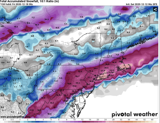
bobjohnsonforthehall wrote:The GFS is an absolute monster this run but it may be over amplifying the confluence a bit as it tends to do. If it is right however...
What's the GFS map showing?
Irish- Pro Enthusiast

- Posts : 788
Join date : 2019-01-16
SoulSingMG- Senior Enthusiast

- Posts : 2853
Join date : 2013-12-11

Irish- Pro Enthusiast

- Posts : 788
Reputation : 19
Join date : 2019-01-16
Age : 45
Location : Old Bridge, NJ
 Re: DECEMBER 16th 17th 2020 Snow Threat???
Irish wrote:bobjohnsonforthehall wrote:The GFS is an absolute monster this run but it may be over amplifying the confluence a bit as it tends to do. If it is right however...
What's the GFS map showing?
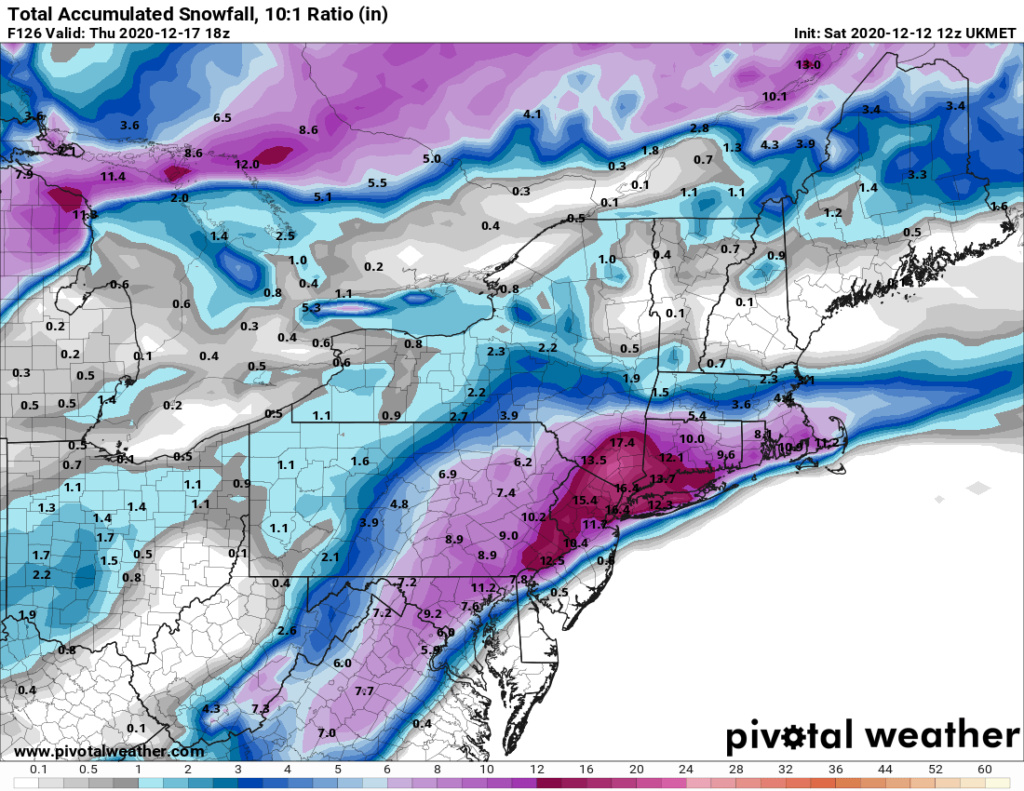
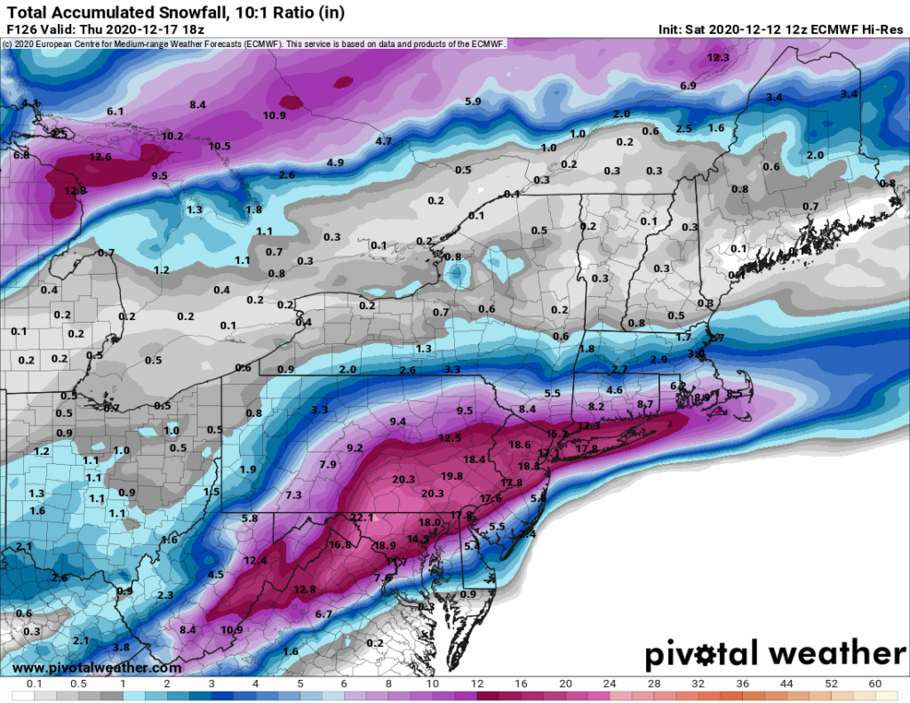
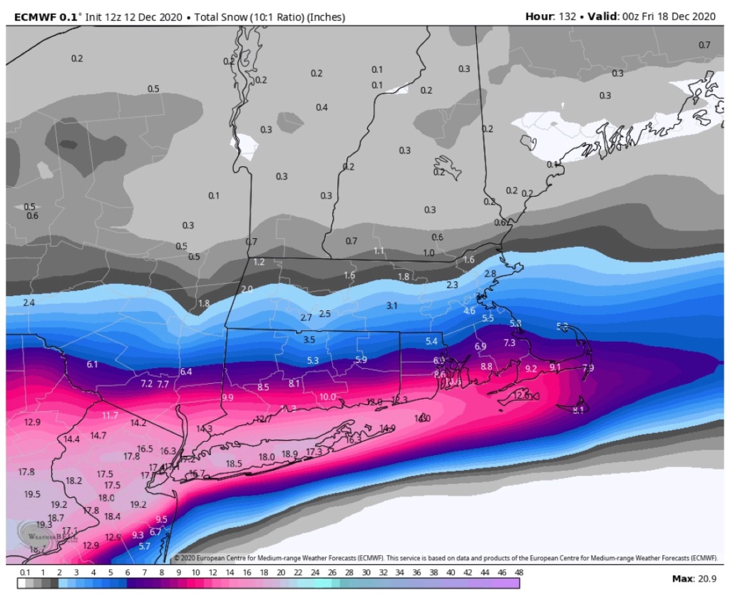
A swath of 15-20 inches from Maryland through SE PA through central/north Jersey and eastern half of CT. I'm not paying too much attention run to run but that certainly caught my eye. Canadian is similar.

bobjohnsonforthehall- Posts : 311
Reputation : 19
Join date : 2016-10-02
Location : Flemington NJ
Irish likes this post
frank 638- Senior Enthusiast

- Posts : 2843
Reputation : 37
Join date : 2016-01-01
Age : 40
Location : bronx ny
 Re: DECEMBER 16th 17th 2020 Snow Threat???
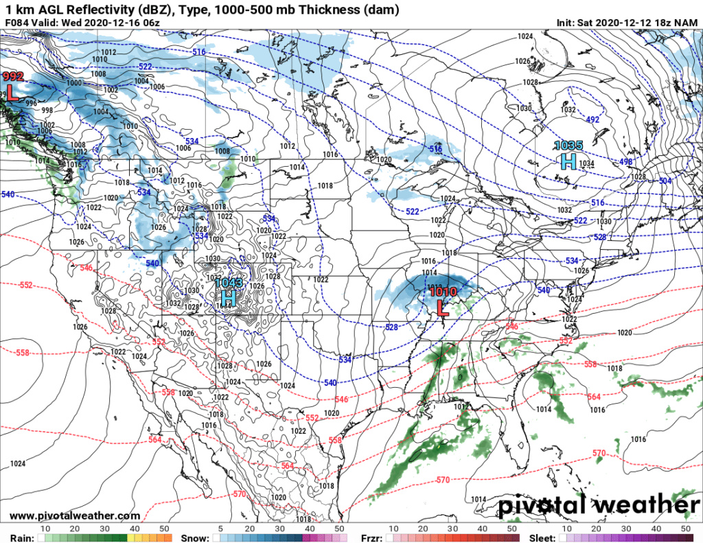
Just something observed today. More of a Miller A characteristic storm. They usually bode better for this latitude/longitude than the Miller B which definitely favor NE. Nothing is set in stone obviously at this range...
The consistency has been the ridge in PNA region, the 50/50 low and the pinned HP in Quebec. Those synoptically are solid so far...
The consistency has been the ridge in PNA region, the 50/50 low and the pinned HP in Quebec. Those synoptically are solid so far...
heehaw453- Advanced Forecaster

- Posts : 3906
Reputation : 86
Join date : 2014-01-20
Location : Bedminster Township, PA Elevation 600' ASL
GreyBeard likes this post

jmanley32- Senior Enthusiast

- Posts : 20535
Reputation : 108
Join date : 2013-12-12
Age : 43
Location : Yonkers, NY

nutleyblizzard- Senior Enthusiast

- Posts : 1954
Reputation : 41
Join date : 2014-01-30
Age : 58
Location : Nutley, new jersey
 Re: DECEMBER 16th 17th 2020 Snow Threat???
remember soul we dont wanna be in the busseye which we are here, lets hope that the whole board looks more like the Euro and GFS, I am rooting for this one and am just as anxious as others about Monday but will not let it get to me too much here as said cautious optimism.

jmanley32- Senior Enthusiast

- Posts : 20535
Reputation : 108
Join date : 2013-12-12
Age : 43
Location : Yonkers, NY
 Re: DECEMBER 16th 17th 2020 Snow Threat???
Wow is all I can say on these snow maps, I know better than to take them verbatim but the steadfast and consistency and moreso the AGREEMENT this far out of having almost all the same areas and NYC and all around including Long Island could see 15-20+ inches by Thursday is incredible. I am leaning into the pool to go all in but waiting another day or two, and ugg please don't mention Juno...I remember how crazy that was we completely shutdown here and got like a inche I think, that sustinance or whatever its called killed us. And the news roasted all meterologists when it was def not their fault.

jmanley32- Senior Enthusiast

- Posts : 20535
Reputation : 108
Join date : 2013-12-12
Age : 43
Location : Yonkers, NY
 Re: DECEMBER 16th 17th 2020 Snow Threat???
heehaw453 wrote:Just something observed today. More of a Miller A characteristic storm. They usually bode better for this latitude/longitude than the Miller B which definitely favor NE. Nothing is set in stone obviously at this range...
The consistency has been the ridge in PNA region, the 50/50 low and the pinned HP in Quebec. Those synoptically are solid so far...
Love those Miller A's. As you say, they bode better for our area. Basically a Noreaster, no? Used to see storms start out in the northwest, dive down into the gulf and pick up a ton of moisture, then track up the east coast and drop a bomb on us.
GreyBeard- Senior Enthusiast

- Posts : 725
Reputation : 34
Join date : 2014-02-12
Location : eastern nassau county

hyde345- Pro Enthusiast

- Posts : 1082
Reputation : 48
Join date : 2013-01-08
Location : Hyde Park, NY

aiannone- Senior Enthusiast - Mod

- Posts : 4815
Reputation : 92
Join date : 2013-01-07
Location : Saint James, LI (Northwest Suffolk Co.)
 Re: DECEMBER 16th 17th 2020 Snow Threat???
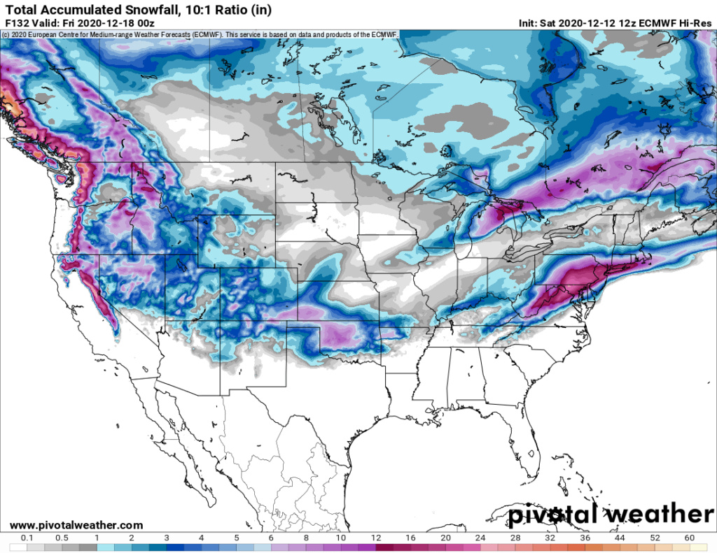
The storm gets kicked out instead of going up through to NE. The block is probably causing that. Too early to say if that's real or not. My guess is the Euro is being too aggressive with that, however I don't see this being a threat beyond SNE.
heehaw453- Advanced Forecaster

- Posts : 3906
Reputation : 86
Join date : 2014-01-20
Location : Bedminster Township, PA Elevation 600' ASL
 Re: DECEMBER 16th 17th 2020 Snow Threat???
jmanley32 wrote:Wow is all I can say on these snow maps, I know better than to take them verbatim but the steadfast and consistency and moreso the AGREEMENT this far out of having almost all the same areas and NYC and all around including Long Island could see 15-20+ inches by Thursday is incredible. I am leaning into the pool to go all in but waiting another day or two, and ugg please don't mention Juno...I remember how crazy that was we completely shutdown here and got like a inche I think, that sustinance or whatever its called killed us. And the news roasted all meterologists when it was def not their fault.
To be this far out and have this much consensus is either interesting or disconcerting depending on how people wish to perceive it. I agree with you that it is rather impressive and gives me some hope. Cautiously however, as the pieces won't all be sampled for another 24 hours or so.

bobjohnsonforthehall- Posts : 311
Reputation : 19
Join date : 2016-10-02
Location : Flemington NJ

jmanley32- Senior Enthusiast

- Posts : 20535
Reputation : 108
Join date : 2013-12-12
Age : 43
Location : Yonkers, NY
 Re: DECEMBER 16th 17th 2020 Snow Threat???
GreyBeard wrote:heehaw453 wrote:Just something observed today. More of a Miller A characteristic storm. They usually bode better for this latitude/longitude than the Miller B which definitely favor NE. Nothing is set in stone obviously at this range...
The consistency has been the ridge in PNA region, the 50/50 low and the pinned HP in Quebec. Those synoptically are solid so far...
Love those Miller A's. As you say, they bode better for our area. Basically a Noreaster, no? Used to see storms start out in the northwest, dive down into the gulf and pick up a ton of moisture, then track up the east coast and drop a bomb on us.
Totally agree. Miller A much higher likelihood of success around here. Due to the strong high to the north it won't take much pressure drop to generate decent wind too. I don't expect this to bomb out without other streams injecting into it, but it really doesn't need to to be prolific.
heehaw453- Advanced Forecaster

- Posts : 3906
Reputation : 86
Join date : 2014-01-20
Location : Bedminster Township, PA Elevation 600' ASL
 Re: DECEMBER 16th 17th 2020 Snow Threat???
Looking at the 850mb winds I think this could have at least a period of B word potential.heehaw453 wrote:GreyBeard wrote:heehaw453 wrote:Just something observed today. More of a Miller A characteristic storm. They usually bode better for this latitude/longitude than the Miller B which definitely favor NE. Nothing is set in stone obviously at this range...
The consistency has been the ridge in PNA region, the 50/50 low and the pinned HP in Quebec. Those synoptically are solid so far...
Love those Miller A's. As you say, they bode better for our area. Basically a Noreaster, no? Used to see storms start out in the northwest, dive down into the gulf and pick up a ton of moisture, then track up the east coast and drop a bomb on us.
Totally agree. Miller A much higher likelihood of success around here. Due to the strong high to the north it won't take much pressure drop to generate decent wind too. I don't expect this to bomb out without other streams injecting into it, but it really doesn't need to to be prolific.

jmanley32- Senior Enthusiast

- Posts : 20535
Reputation : 108
Join date : 2013-12-12
Age : 43
Location : Yonkers, NY
 Re: DECEMBER 16th 17th 2020 Snow Threat???
heehaw453 wrote:
The storm gets kicked out instead of going up through to NE. The block is probably causing that. Too early to say if that's real or not. My guess is the Euro is being too aggressive with that, however I don't see this being a threat beyond SNE.
The block is definitely responsible and I was surprised by the significant qpf reduction in northern areas after some great 12z model runs but it is an operational after all. The 00z and 12z EPS is very similar.

hyde345- Pro Enthusiast

- Posts : 1082
Reputation : 48
Join date : 2013-01-08
Location : Hyde Park, NY
 Re: DECEMBER 16th 17th 2020 Snow Threat???
_________________
_______________________________________________________________________________________________________
CLICK HERE to view NJ Strong Snowstorm Classifications
 Re: DECEMBER 16th 17th 2020 Snow Threat???
Presuming this bodes well for a massive storm? You said potential for a Roidzilla, what was that again 12-24? From the models the middle of that seems quite possible for a large area depending on how much of wednesdays maps are including Monday. Nontheless this is great to be tracking something that potentially is going to be great for nearly all on the board, I am hoping precip can be a bit more north for the northern guys but not so much that we rain down here haha

jmanley32- Senior Enthusiast

- Posts : 20535
Reputation : 108
Join date : 2013-12-12
Age : 43
Location : Yonkers, NY
 Re: DECEMBER 16th 17th 2020 Snow Threat???
Has anyone noticed JB seems to be unsettled about this low. His thinking is models will correct warmer. Kind of scares me coming from Bastardi...

mmanisca- Pro Enthusiast

- Posts : 299
Reputation : 3
Join date : 2013-01-23
Age : 65
Location : Deer Park, Long Island

Irish- Pro Enthusiast

- Posts : 788
Reputation : 19
Join date : 2019-01-16
Age : 45
Location : Old Bridge, NJ
 Re: DECEMBER 16th 17th 2020 Snow Threat???
I had not checked on him, one thing I do know about him, he is either dead wrong or spot on. Yeah thats jarring to say the least. Meanwhile wow my area has 9 to 15 wed and wed night...jeezemmanisca wrote:Has anyone noticed JB seems to be unsettled about this low. His thinking is models will correct warmer. Kind of scares me coming from Bastardi...

jmanley32- Senior Enthusiast

- Posts : 20535
Reputation : 108
Join date : 2013-12-12
Age : 43
Location : Yonkers, NY
 Re: DECEMBER 16th 17th 2020 Snow Threat???
Yeah and the latest run of the gfs is more NW but it’s only a run and will need to chill and not get run crazy. Just a bummer when there’s been so much agreement and consistency

mmanisca- Pro Enthusiast

- Posts : 299
Reputation : 3
Join date : 2013-01-23
Age : 65
Location : Deer Park, Long Island
 Re: DECEMBER 16th 17th 2020 Snow Threat???
H5 looked just as good that run, strong HP, more pressing confluence. We'll see what overnight runs bring. Heck it's still a great storm, not spitting out the 20" plus totals but you only want to see those numbers from a Miller A when its gone and we are measuring.
_________________
Mugs
AKA:King: Snow Weenie
Self Proclaimed
WINTER 2014-15 : 55.12" +.02 for 6 coatings (avg. 35")
WINTER 2015-16 Total - 29.8" (Avg 35")
WINTER 2016-17 : 39.5" so far

amugs- Advanced Forecaster - Mod

- Posts : 15095
Reputation : 213
Join date : 2013-01-07
Age : 54
Location : Hillsdale,NJ
 Re: DECEMBER 16th 17th 2020 Snow Threat???
For my area I am getting 20 inches of snow I hope this is true
frank 638- Senior Enthusiast

- Posts : 2843
Reputation : 37
Join date : 2016-01-01
Age : 40
Location : bronx ny
Page 3 of 24 •  1, 2, 3, 4 ... 13 ... 24
Page 3 of 24
Permissions in this forum:
You cannot reply to topics in this forum|
|
|

 Home
Home