JAN 26th Light Snowfall
+25
Dunnzoo
frank 638
jaydoy
HectorO
kalleg
docstox12
1190ftalt
essexcountypete
dkodgis
CPcantmeasuresnow
weatherwatchermom
Math23x7
bobjohnsonforthehall
aiannone
brownie
GreyBeard
hyde345
jmanley32
Irish
heehaw453
sroc4
amugs
billg315
algae888
Frank_Wx
29 posters
Page 1 of 6 • 1, 2, 3, 4, 5, 6 
 JAN 26th Light Snowfall
The potential for a winter storm and measurable snowfall is increasing for late Monday into Tuesday of next week.
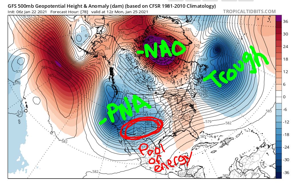
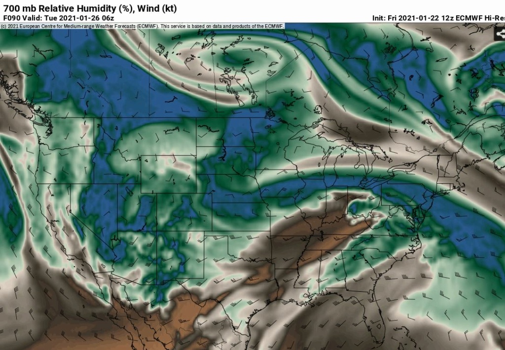
The set-up is interesting in that the Pacific is burying all of the energy in the SW CONUS (-PNA), but the west-based -NAO and dip in the jet stream over New England is preventing the SE Ridge from gaining too much longitude along the east coast. One of the pieces of energy in the SW CONUS is able to escape the 'mega' trough and eject into the mid-section of the country. This energy matures into a low pressure system that ends up tracking virtually west to east across the country. The big question being, exactly how far north does this system get? Some models have the energy not gaining longitude and staying to our south, while others showing it getting far enough north to impact our area with precipitation.

The 06z GFS tracked the low pressure almost perfectly for snow lovers across NNJ/NYC Metro. In this image, you can see the low made it as far north as Ohio. What's important to take away is not just the location of the low, but the dark blue shades indicate the GFS has trended a lot stronger with the storm. At one point getting down to 995mb before transferring its energy off the coast. The gradient, or baroclinic zone, contains the best mechanics and is where the heaviest snow will fall if you are just north-northwest of it.
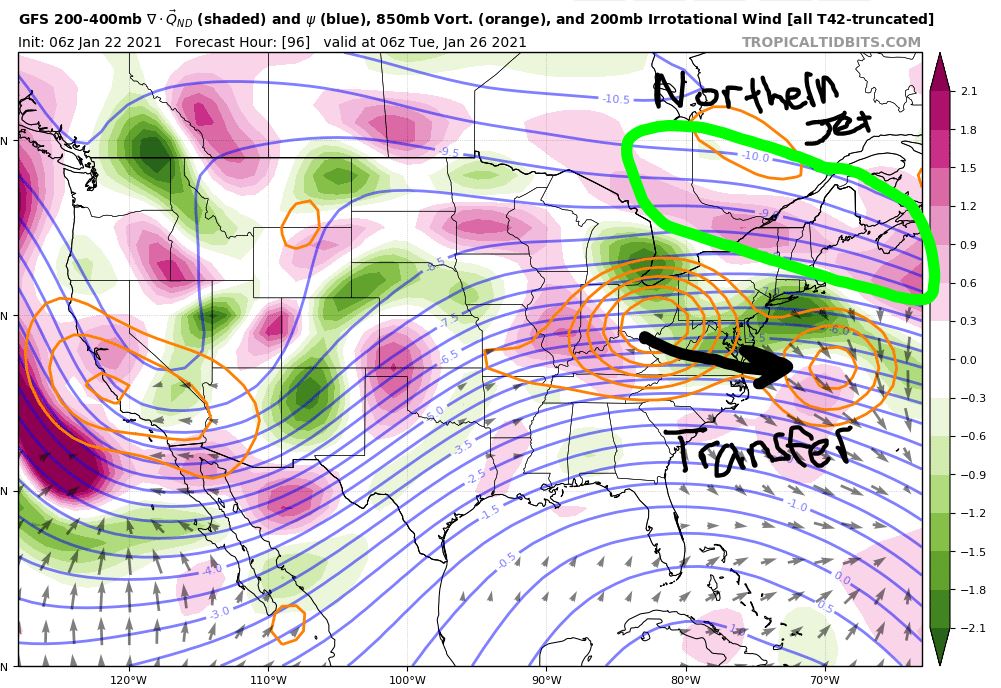
A clearer look at 850mb shows how the polar jet stream is essentially forced to dip over New England due to the -NAO. This is why a sharp cut-off of snow accumulation is likely for areas north-northwest of NYC, because the low pressure ends up transferring energy off the coast.

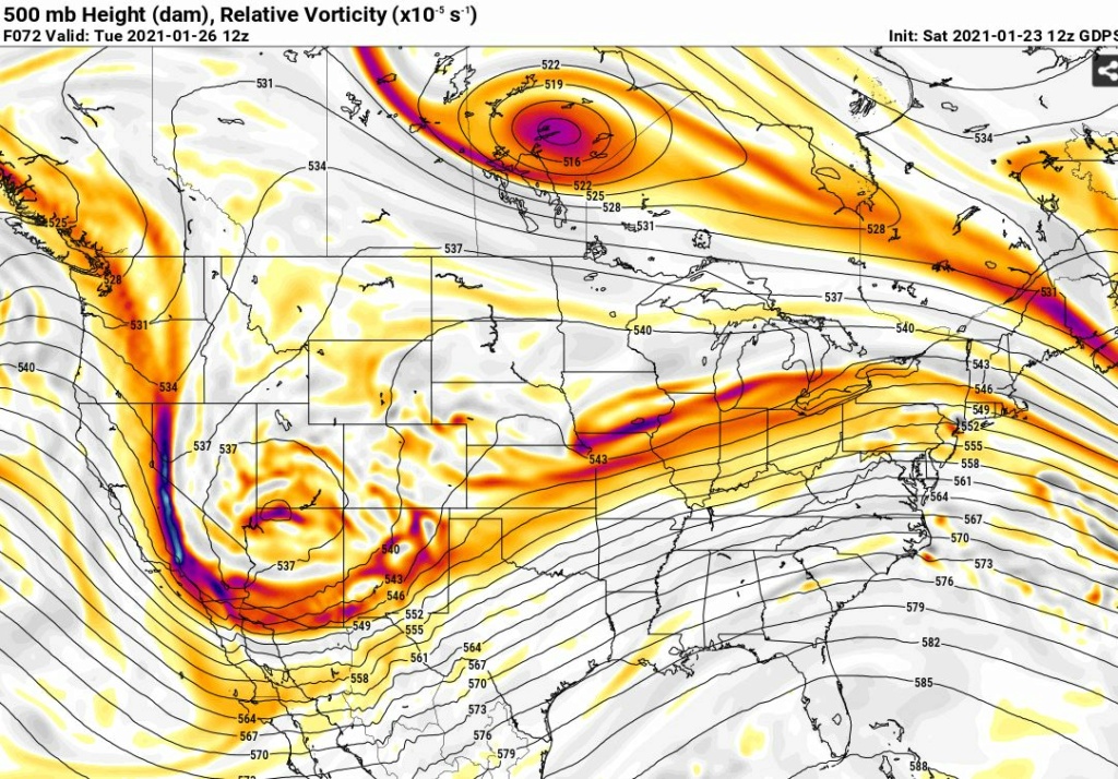
The H5 vorticity extends all the way back to the SW CONUS, which is where this storm originated from. A strong piece of it tracks directly over our area on the latest GFS. The heaviest accumulations are seen west all the way to SW NY and northern PA because the initial forcing or WAA's are north of us. However, if the primary low on the GFS took a track a little more south, we would have been hit with the best banding of snow. This is a big uncertainty right now.

It is also worth mentioning that we're not under the coldest of air masses. This will be an issue for the shore points and central/southern NJ, unless the primary low follows a path way south from where the GFS has it currently. That is still on the table (southern slider) if the confluence over New England trends stronger or the energy associated with the primary low trends weaker. However, as you saw the GFS is trending stronger with the low. So things would have to change over the next 48 hours for that solution to come to fruition.

The set-up is interesting in that the Pacific is burying all of the energy in the SW CONUS (-PNA), but the west-based -NAO and dip in the jet stream over New England is preventing the SE Ridge from gaining too much longitude along the east coast. One of the pieces of energy in the SW CONUS is able to escape the 'mega' trough and eject into the mid-section of the country. This energy matures into a low pressure system that ends up tracking virtually west to east across the country. The big question being, exactly how far north does this system get? Some models have the energy not gaining longitude and staying to our south, while others showing it getting far enough north to impact our area with precipitation.

The 06z GFS tracked the low pressure almost perfectly for snow lovers across NNJ/NYC Metro. In this image, you can see the low made it as far north as Ohio. What's important to take away is not just the location of the low, but the dark blue shades indicate the GFS has trended a lot stronger with the storm. At one point getting down to 995mb before transferring its energy off the coast. The gradient, or baroclinic zone, contains the best mechanics and is where the heaviest snow will fall if you are just north-northwest of it.

A clearer look at 850mb shows how the polar jet stream is essentially forced to dip over New England due to the -NAO. This is why a sharp cut-off of snow accumulation is likely for areas north-northwest of NYC, because the low pressure ends up transferring energy off the coast.

The H5 vorticity extends all the way back to the SW CONUS, which is where this storm originated from. A strong piece of it tracks directly over our area on the latest GFS. The heaviest accumulations are seen west all the way to SW NY and northern PA because the initial forcing or WAA's are north of us. However, if the primary low on the GFS took a track a little more south, we would have been hit with the best banding of snow. This is a big uncertainty right now.

It is also worth mentioning that we're not under the coldest of air masses. This will be an issue for the shore points and central/southern NJ, unless the primary low follows a path way south from where the GFS has it currently. That is still on the table (southern slider) if the confluence over New England trends stronger or the energy associated with the primary low trends weaker. However, as you saw the GFS is trending stronger with the low. So things would have to change over the next 48 hours for that solution to come to fruition.
Last edited by Frank_Wx on Sun Jan 24, 2021 7:45 am; edited 1 time in total
_________________
_______________________________________________________________________________________________________
CLICK HERE to view NJ Strong Snowstorm Classifications
 Re: JAN 26th Light Snowfall
One thing I didn't like on guidance today was the very dry air in place which delayed the onset of precipitation from 7:00 p.m. Monday to 1:00 a.m. Tuesday. The persistent pattern has been shearing out of systems due to the confluence to our North With the 5050 low and the negative nao. Like our chances for a light to moderate event 2 to 6" seems a good call at this time. Western ateas probably seeing the heaviest snow.

algae888- Advanced Forecaster

- Posts : 5311
Reputation : 46
Join date : 2013-02-05
Age : 62
Location : mt. vernon, new york
 Re: JAN 26th Light Snowfall
Great write-up Frank.
Always funny to see the dance the models do. Early in the week the GFS didn't look great and the Euro did, last night and this morning was sort of the opposite (btw, anyone else having trouble with the latest Euro runs?). That said, the way things have been going I'll take a good 2-6" event and hope it sets the table for the end of the week threats. If this takes the "perfect" track -- and where you are will determine what you consider to be the "perfect" track -- and "over-performs" and we get more than 6", all the merrier.
Always funny to see the dance the models do. Early in the week the GFS didn't look great and the Euro did, last night and this morning was sort of the opposite (btw, anyone else having trouble with the latest Euro runs?). That said, the way things have been going I'll take a good 2-6" event and hope it sets the table for the end of the week threats. If this takes the "perfect" track -- and where you are will determine what you consider to be the "perfect" track -- and "over-performs" and we get more than 6", all the merrier.

billg315- Advanced Forecaster - Mod

- Posts : 4483
Reputation : 185
Join date : 2015-01-24
Age : 50
Location : Flemington, NJ
 Re: JAN 26th Light Snowfall
EURO just shears out the storm as Al referenced to a worry at this time.
 .
.
 .
._________________
Mugs
AKA:King: Snow Weenie
Self Proclaimed
WINTER 2014-15 : 55.12" +.02 for 6 coatings (avg. 35")
WINTER 2015-16 Total - 29.8" (Avg 35")
WINTER 2016-17 : 39.5" so far

amugs- Advanced Forecaster - Mod

- Posts : 15095
Reputation : 213
Join date : 2013-01-07
Age : 54
Location : Hillsdale,NJ
 Re: JAN 26th Light Snowfall
amugs wrote:EURO just shears out the storm as Al referenced to a worry at this time..
I think its more the subsidence created as the primary low begins to transfer off the coast. In between lows you get the dreaded subsidence due to relative HP in between.
_________________
"In weather and in life, there's no winning and losing; there's only winning and learning."
WINTER 2012/2013 TOTALS 43.65"WINTER 2017/2018 TOTALS 62.85" WINTER 2022/2023 TOTALS 4.9"
WINTER 2013/2014 TOTALS 64.85"WINTER 2018/2019 TOTALS 14.25" WINTER 2023/2024 TOTALS 13.1"
WINTER 2014/2015 TOTALS 71.20"WINTER 2019/2020 TOTALS 6.35"
WINTER 2015/2016 TOTALS 35.00"WINTER 2020/2021 TOTALS 37.75"
WINTER 2016/2017 TOTALS 42.25"WINTER 2021/2022 TOTALS 31.65"

sroc4- Admin

- Posts : 8354
Reputation : 302
Join date : 2013-01-07
Location : Wading River, LI
heehaw453- Advanced Forecaster

- Posts : 3906
Reputation : 86
Join date : 2014-01-20
Location : Bedminster Township, PA Elevation 600' ASL
 Re: JAN 26th Light Snowfall
The last runs seem to have favored a later start and mixing on Tuesday. Therefore, dropping totals from 4-8 down to 2-6.

Irish- Pro Enthusiast

- Posts : 788
Reputation : 19
Join date : 2019-01-16
Age : 45
Location : Old Bridge, NJ
 Re: JAN 26th Light Snowfall
Irish wrote:The last runs seem to have favored a later start and mixing on Tuesday. Therefore, dropping totals from 4-8 down to 2-6.
I think it may be more of a drop in QPF vs mixing thats dropping totals for your area
_________________
"In weather and in life, there's no winning and losing; there's only winning and learning."
WINTER 2012/2013 TOTALS 43.65"WINTER 2017/2018 TOTALS 62.85" WINTER 2022/2023 TOTALS 4.9"
WINTER 2013/2014 TOTALS 64.85"WINTER 2018/2019 TOTALS 14.25" WINTER 2023/2024 TOTALS 13.1"
WINTER 2014/2015 TOTALS 71.20"WINTER 2019/2020 TOTALS 6.35"
WINTER 2015/2016 TOTALS 35.00"WINTER 2020/2021 TOTALS 37.75"
WINTER 2016/2017 TOTALS 42.25"WINTER 2021/2022 TOTALS 31.65"

sroc4- Admin

- Posts : 8354
Reputation : 302
Join date : 2013-01-07
Location : Wading River, LI
 Re: JAN 26th Light Snowfall
I'm going to go into this system with a healthy dose of skepticism for anything above the 2-6" that Algae referenced above, sticking to my 2-4" as most likely. I just don't feel like this type of setup with all the variables, (subsidence, mixing, fast moving) ever produces for us like a classic coastal storm. Again though, to reiterate what I said above, I'll be quite happy with a 2-6" snowfall as it is nothing sneeze at.
Btw, if NYC gets 4" (take the middle) I believe they'll be above normal for the period Dec. through the end of January? No?
Btw, if NYC gets 4" (take the middle) I believe they'll be above normal for the period Dec. through the end of January? No?

billg315- Advanced Forecaster - Mod

- Posts : 4483
Reputation : 185
Join date : 2015-01-24
Age : 50
Location : Flemington, NJ
 Re: JAN 26th Light Snowfall
billg315 wrote:I'm going to go into this system with a healthy dose of skepticism for anything above the 2-6" that Algae referenced above, sticking to my 2-4" as most likely. I just don't feel like this type of setup with all the variables, (subsidence, mixing, fast moving) ever produces for us like a classic coastal storm. Again though, to reiterate what I said above, I'll be quite happy with a 2-6" snowfall as it is nothing sneeze at.
Btw, if NYC gets 4" (take the middle) I believe they'll be above normal for the period Dec. through the end of January? No?
Yep. That'd put them close to 15" if they got 4". Considering February is the snowiest month for CPK they'd be near normal snowfall. For many of us February and March will need to produce to have any legit shot at normal snowfall...
heehaw453- Advanced Forecaster

- Posts : 3906
Reputation : 86
Join date : 2014-01-20
Location : Bedminster Township, PA Elevation 600' ASL
heehaw453- Advanced Forecaster

- Posts : 3906
Reputation : 86
Join date : 2014-01-20
Location : Bedminster Township, PA Elevation 600' ASL
 Re: JAN 26th Light Snowfall
Predictions for my area are back up to 4-8 inches. The latest runs must be better.

Irish- Pro Enthusiast

- Posts : 788
Reputation : 19
Join date : 2019-01-16
Age : 45
Location : Old Bridge, NJ
 Re: JAN 26th Light Snowfall
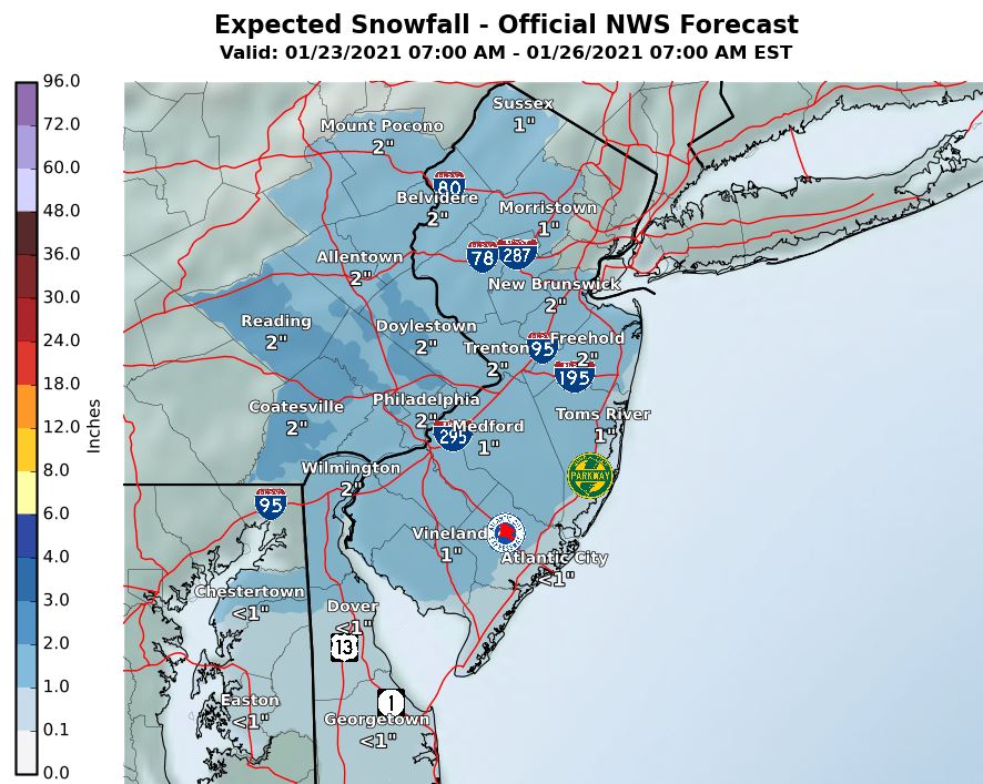
Models are not enthused at the moment. They’re showing a light snowfall with some mixing in southern portions of our area. At this time, this is looking like a 1-3 inch event, possibly 2-4 N&W of NYC. The energy is being sheared out and that could be due to the bigger storm that is looming for the 28th
_________________
_______________________________________________________________________________________________________
CLICK HERE to view NJ Strong Snowstorm Classifications
heehaw453- Advanced Forecaster

- Posts : 3906
Reputation : 86
Join date : 2014-01-20
Location : Bedminster Township, PA Elevation 600' ASL
 Re: JAN 26th Light Snowfall
Nice little appetizer to what could be a bigger storm and the one behind it to open up February as well.
_________________
Mugs
AKA:King: Snow Weenie
Self Proclaimed
WINTER 2014-15 : 55.12" +.02 for 6 coatings (avg. 35")
WINTER 2015-16 Total - 29.8" (Avg 35")
WINTER 2016-17 : 39.5" so far

amugs- Advanced Forecaster - Mod

- Posts : 15095
Reputation : 213
Join date : 2013-01-07
Age : 54
Location : Hillsdale,NJ
 Re: JAN 26th Light Snowfall
Irish wrote:Predictions for my area are back up to 4-8 inches. The latest runs must be better.
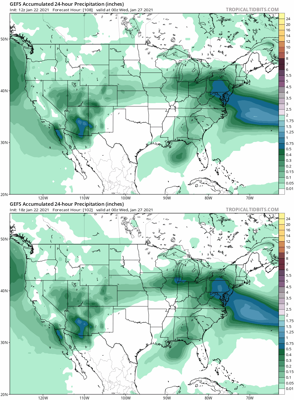
The GEFS dried up last several runs. You'll probably see WTC back down as they weigh heavily on the GFS for their forecasts.
heehaw453- Advanced Forecaster

- Posts : 3906
Reputation : 86
Join date : 2014-01-20
Location : Bedminster Township, PA Elevation 600' ASL
 Re: JAN 26th Light Snowfall
heehaw453 wrote:Irish wrote:Predictions for my area are back up to 4-8 inches. The latest runs must be better.
The GEFS dried up last several runs. You'll probably see WTC back down as they weigh heavily on the GFS for their forecasts.
They have, down to a 2-4 event. And they've started to post initial accumulation predictions for the 28th.

Irish- Pro Enthusiast

- Posts : 788
Reputation : 19
Join date : 2019-01-16
Age : 45
Location : Old Bridge, NJ
 Re: JAN 26th Light Snowfall
Frank_Wx wrote:Models are not enthused at the moment. They’re showing a light snowfall with some mixing in southern portions of our area. At this time, this is looking like a 1-3 inch event, possibly 2-4 N&W of NYC. The energy is being sheared out and that could be due to the bigger storm that is looming for the 28th
Great point. Models that were more robust with the moisture into the area a few days ago no longer have any sort of consolidation of energy. Its evolved into one long strung out wave as it traverses the plains and into the eastern 1/3rd of the country, thus greatly reducing the vertical lift mechanisms hence the drastic drop in QPF. Put another way wave spacing is less than ideal between the Tuesday threat and the Thursday threat. The overall pattern and strength of the blocking being a major contributing factor as to why. Nothing too surprising in the end as this threat was always a minor to mod event ceiling anyway with the idea that shearing of this energy was a distinct possibility. We are still 48-72 hrs out so Ill certainly cont to monitor for subtle changes to the governing dynamics of this threat and changes to QPF but certainly the trends have been to dry it out.
sroc4 wrote:billg315 wrote:Euro seems overly aggressive on snowfall totals for this type of event, and the GFS is maybe underplaying a bit. So I think a happy medium right now of a few inches before a changeover is the best takeaway at this time. Now areas north of NYC metro and far NW NJ -- where the cold air will be even more entrenched, could perform better on the snow end. Again, assuming the models hold for the next 6 days.
We shall see Bill. Im not convinced a changeover is the concern here. With the -NAO and -AO firmly entrenched in the pattern I think a sheared out system like GFS depicts, or a system that slides south is more the concern. PNA looks to be strongly neg, and the EPO is meh as we round out the weekend. Nothing to allow nothern energy to dig, and I doubt the southern energy is amplified enough to raise heights out ahead due to the strong blocking in place, therefore IMHO of course it either works out perfect with little to no change over, esp the further off the coast, or nothing much at all. But again its all in the Md to LR at the moment so nothing to get excited/worried about for now anyway.
Meet you in the pool of cautious optimism for a cocktail for the 12z runs.
CURRENT CMC

CMC from several days ago

Last edited by sroc4 on Sat Jan 23, 2021 10:08 am; edited 1 time in total
_________________
"In weather and in life, there's no winning and losing; there's only winning and learning."
WINTER 2012/2013 TOTALS 43.65"WINTER 2017/2018 TOTALS 62.85" WINTER 2022/2023 TOTALS 4.9"
WINTER 2013/2014 TOTALS 64.85"WINTER 2018/2019 TOTALS 14.25" WINTER 2023/2024 TOTALS 13.1"
WINTER 2014/2015 TOTALS 71.20"WINTER 2019/2020 TOTALS 6.35"
WINTER 2015/2016 TOTALS 35.00"WINTER 2020/2021 TOTALS 37.75"
WINTER 2016/2017 TOTALS 42.25"WINTER 2021/2022 TOTALS 31.65"

sroc4- Admin

- Posts : 8354
Reputation : 302
Join date : 2013-01-07
Location : Wading River, LI
Frank_Wx likes this post
 Re: JAN 26th Light Snowfall
I’ve said all along I felt this as a 2-4 type event. I think that is shaping up. Now I will point out, 2-4” events can have bigger impacts depending on timing. If this hits right before rush hour starts Tuesday AM it could create headaches. Heck we had almost 1” of snow here Wednesday AM and the unplowed roads with hills were tough to navigate.

billg315- Advanced Forecaster - Mod

- Posts : 4483
Reputation : 185
Join date : 2015-01-24
Age : 50
Location : Flemington, NJ
Frank_Wx likes this post
 Re: JAN 26th Light Snowfall
sroc4 wrote:Frank_Wx wrote:Models are not enthused at the moment. They’re showing a light snowfall with some mixing in southern portions of our area. At this time, this is looking like a 1-3 inch event, possibly 2-4 N&W of NYC. The energy is being sheared out and that could be due to the bigger storm that is looming for the 28th
Great point. Models that were more robust with the moisture into the area a few days ago no longer have any sort of consolidation of energy. Its evolved into one long strung out wave as it traverses the plains and into the eastern 1/3rd of the country, thus greatly reducing the vertical lift mechanisms hence the drastic drop in QPF. Put another way wave spacing is less than ideal between the Tuesday threat and the Thursday threat. The overall pattern and strength of the blocking being a major contributing factor as to why. Nothing too surprising in the end as this threat was always a minor to mod event ceiling anyway with the idea that shearing of this energy was a distinct possibility. We are still 48-72 hrs out so Ill certainly cont to monitor for subtle changes to the governing dynamics of this threat and changes to QPF but certainly the trends have been to dry it out.sroc4 wrote:billg315 wrote:Euro seems overly aggressive on snowfall totals for this type of event, and the GFS is maybe underplaying a bit. So I think a happy medium right now of a few inches before a changeover is the best takeaway at this time. Now areas north of NYC metro and far NW NJ -- where the cold air will be even more entrenched, could perform better on the snow end. Again, assuming the models hold for the next 6 days.
We shall see Bill. Im not convinced a changeover is the concern here. With the -NAO and -AO firmly entrenched in the pattern I think a sheared out system like GFS depicts, or a system that slides south is more the concern. PNA looks to be strongly neg, and the EPO is meh as we round out the weekend. Nothing to allow nothern energy to dig, and I doubt the southern energy is amplified enough to raise heights out ahead due to the strong blocking in place, therefore IMHO of course it either works out perfect with little to no change over, esp the further off the coast, or nothing much at all. But again its all in the Md to LR at the moment so nothing to get excited/worried about for now anyway.
Meet you in the pool of cautious optimism for a cocktail for the 12z runs.
CURRENT CMC
CMC from several days ago
Yup. If this means bigger storm two days later I’ll take the trade
_________________
_______________________________________________________________________________________________________
CLICK HERE to view NJ Strong Snowstorm Classifications
sroc4 likes this post
 Re: JAN 26th Light Snowfall
Frank_Wx wrote:sroc4 wrote:Frank_Wx wrote:Models are not enthused at the moment. They’re showing a light snowfall with some mixing in southern portions of our area. At this time, this is looking like a 1-3 inch event, possibly 2-4 N&W of NYC. The energy is being sheared out and that could be due to the bigger storm that is looming for the 28th
Great point. Models that were more robust with the moisture into the area a few days ago no longer have any sort of consolidation of energy. Its evolved into one long strung out wave as it traverses the plains and into the eastern 1/3rd of the country, thus greatly reducing the vertical lift mechanisms hence the drastic drop in QPF. Put another way wave spacing is less than ideal between the Tuesday threat and the Thursday threat. The overall pattern and strength of the blocking being a major contributing factor as to why. Nothing too surprising in the end as this threat was always a minor to mod event ceiling anyway with the idea that shearing of this energy was a distinct possibility. We are still 48-72 hrs out so Ill certainly cont to monitor for subtle changes to the governing dynamics of this threat and changes to QPF but certainly the trends have been to dry it out.sroc4 wrote:billg315 wrote:Euro seems overly aggressive on snowfall totals for this type of event, and the GFS is maybe underplaying a bit. So I think a happy medium right now of a few inches before a changeover is the best takeaway at this time. Now areas north of NYC metro and far NW NJ -- where the cold air will be even more entrenched, could perform better on the snow end. Again, assuming the models hold for the next 6 days.
We shall see Bill. Im not convinced a changeover is the concern here. With the -NAO and -AO firmly entrenched in the pattern I think a sheared out system like GFS depicts, or a system that slides south is more the concern. PNA looks to be strongly neg, and the EPO is meh as we round out the weekend. Nothing to allow nothern energy to dig, and I doubt the southern energy is amplified enough to raise heights out ahead due to the strong blocking in place, therefore IMHO of course it either works out perfect with little to no change over, esp the further off the coast, or nothing much at all. But again its all in the Md to LR at the moment so nothing to get excited/worried about for now anyway.
Meet you in the pool of cautious optimism for a cocktail for the 12z runs.
CURRENT CMC
CMC from several days ago
Yup. If this means bigger storm two days later I’ll take the trade
Totally!
_________________
"In weather and in life, there's no winning and losing; there's only winning and learning."
WINTER 2012/2013 TOTALS 43.65"WINTER 2017/2018 TOTALS 62.85" WINTER 2022/2023 TOTALS 4.9"
WINTER 2013/2014 TOTALS 64.85"WINTER 2018/2019 TOTALS 14.25" WINTER 2023/2024 TOTALS 13.1"
WINTER 2014/2015 TOTALS 71.20"WINTER 2019/2020 TOTALS 6.35"
WINTER 2015/2016 TOTALS 35.00"WINTER 2020/2021 TOTALS 37.75"
WINTER 2016/2017 TOTALS 42.25"WINTER 2021/2022 TOTALS 31.65"

sroc4- Admin

- Posts : 8354
Reputation : 302
Join date : 2013-01-07
Location : Wading River, LI
 Re: JAN 26th Light Snowfall
The big issue with the 2-4” events is most people don’t take them too seriously. But if it starts at, say 2 AM, it doesn’t get to a plowable amount until 7 or 8 after traffic is on the roads, meaning the major roads go unplowed. 3 or 4” especially on hills can cause serious traction issues, then spin outs, then accidents, then closed lanes, then angry people sitting in a traffic jam with snow falling on their car. See the November 2018 storm as an example of how a little moderate snow at the wrong time can cause big problems. By the time 3” had fallen that afternoon the roads were already gridlock.

billg315- Advanced Forecaster - Mod

- Posts : 4483
Reputation : 185
Join date : 2015-01-24
Age : 50
Location : Flemington, NJ
heehaw453- Advanced Forecaster

- Posts : 3906
Reputation : 86
Join date : 2014-01-20
Location : Bedminster Township, PA Elevation 600' ASL
 Re: JAN 26th Light Snowfall
Do not mention though worst storm ever in yonkers history. 18 hrs wife spent sitting in yonkers. Aweful, but they learned, i saw brine down yesterday which made no sense to me.billg315 wrote:The big issue with the 2-4” events is most people don’t take them too seriously. But if it starts at, say 2 AM, it doesn’t get to a plowable amount until 7 or 8 after traffic is on the roads, meaning the major roads go unplowed. 3 or 4” especially on hills can cause serious traction issues, then spin outs, then accidents, then closed lanes, then angry people sitting in a traffic jam with snow falling on their car. See the November 2018 storm as an example of how a little moderate snow at the wrong time can cause big problems. By the time 3” had fallen that afternoon the roads were already gridlock.

jmanley32- Senior Enthusiast

- Posts : 20535
Reputation : 108
Join date : 2013-12-12
Age : 43
Location : Yonkers, NY
 Re: JAN 26th Light Snowfall
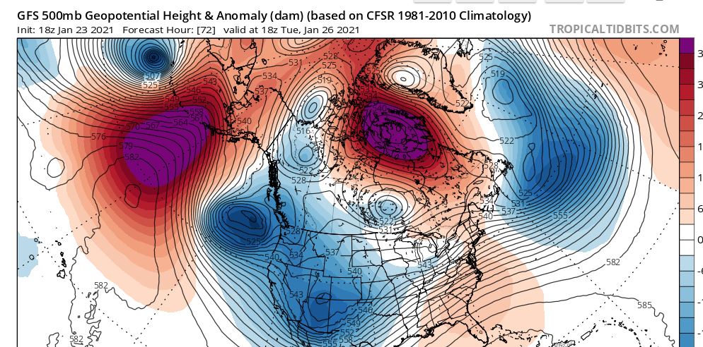
The 50/50 low is pulling out and that is probably letting this ULL get much further north than originally thought. My guess is the thermal profile is going to be marginal and the best forcing is going to be north. The models have been very consistent with showing this inexorable push northward. NEPA, LHV and NW NJ may be the ones to do well with this one...

heehaw453- Advanced Forecaster

- Posts : 3906
Reputation : 86
Join date : 2014-01-20
Location : Bedminster Township, PA Elevation 600' ASL
CPcantmeasuresnow likes this post
Page 1 of 6 • 1, 2, 3, 4, 5, 6 
Permissions in this forum:
You cannot reply to topics in this forum|
|
|

 Home
Home