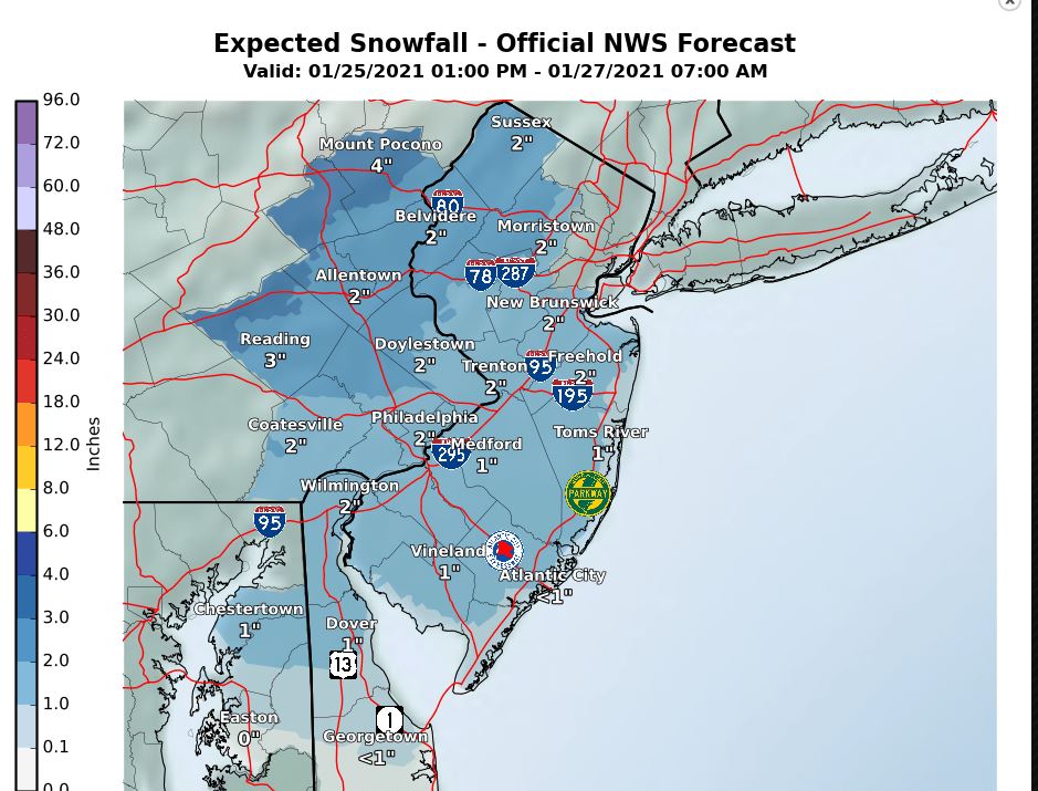
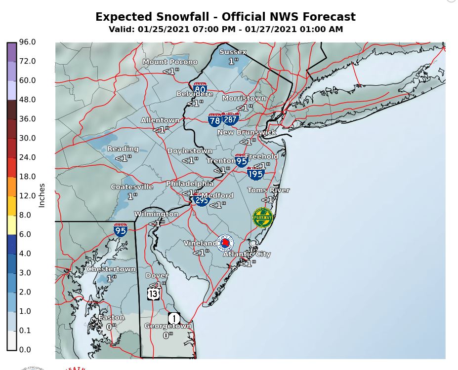
JAN 26th Light Snowfall
+25
Dunnzoo
frank 638
jaydoy
HectorO
kalleg
docstox12
1190ftalt
essexcountypete
dkodgis
CPcantmeasuresnow
weatherwatchermom
Math23x7
bobjohnsonforthehall
aiannone
brownie
GreyBeard
hyde345
jmanley32
Irish
heehaw453
sroc4
amugs
billg315
algae888
Frank_Wx
29 posters
Page 2 of 6 •  1, 2, 3, 4, 5, 6
 Re: JAN 26th Light Snowfall
Do not mention though worst storm ever in yonkers history. 18 hrs wife spent sitting in yonkers. Aweful, but they learned, i saw brine down yesterday which made no sense to me.billg315 wrote:The big issue with the 2-4” events is most people don’t take them too seriously. But if it starts at, say 2 AM, it doesn’t get to a plowable amount until 7 or 8 after traffic is on the roads, meaning the major roads go unplowed. 3 or 4” especially on hills can cause serious traction issues, then spin outs, then accidents, then closed lanes, then angry people sitting in a traffic jam with snow falling on their car. See the November 2018 storm as an example of how a little moderate snow at the wrong time can cause big problems. By the time 3” had fallen that afternoon the roads were already gridlock.
jmanley32- Senior Enthusiast

- Posts : 20535
Join date : 2013-12-12
 Re: JAN 26th Light Snowfall
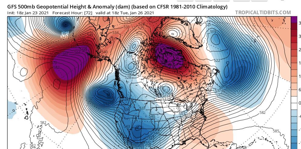
The 50/50 low is pulling out and that is probably letting this ULL get much further north than originally thought. My guess is the thermal profile is going to be marginal and the best forcing is going to be north. The models have been very consistent with showing this inexorable push northward. NEPA, LHV and NW NJ may be the ones to do well with this one...

heehaw453- Advanced Forecaster

- Posts : 3906
Join date : 2014-01-20
CPcantmeasuresnow likes this post
 Re: JAN 26th Light Snowfall
I changed the title of the thread as clearly we’re looking at very little snowfall from this storm. But would not shock me if places well N&W get at or above 4 inches like the GFS shows


_________________
_______________________________________________________________________________________________________
CLICK HERE to view NJ Strong Snowstorm Classifications
heehaw453- Advanced Forecaster

- Posts : 3906
Reputation : 86
Join date : 2014-01-20
Location : Bedminster Township, PA Elevation 600' ASL
heehaw453- Advanced Forecaster

- Posts : 3906
Reputation : 86
Join date : 2014-01-20
Location : Bedminster Township, PA Elevation 600' ASL
 Re: JAN 26th Light Snowfall
Timing of this could still cause some outsized travel impacts so while its a minor event plan for slower than normal commutes.

billg315- Advanced Forecaster - Mod

- Posts : 4483
Reputation : 185
Join date : 2015-01-24
Age : 50
Location : Flemington, NJ
 Re: JAN 26th Light Snowfall
Seems like the models are trending toward this being more of a Tuesday/Tuesday night event than a Monday into Tuesday AM. That’s why we’ll have to keep an eye on the evening commute. Might just be moving in for the AM rush but could be causing problems for the drive-home.

billg315- Advanced Forecaster - Mod

- Posts : 4483
Reputation : 185
Join date : 2015-01-24
Age : 50
Location : Flemington, NJ
 Re: JAN 26th Light Snowfall
Timing on this has really shifted in a couple days. A few days ago it looked like snow could start as early as Monday evening in spots, but the way it has played out might not see anything until after sunrise Tuesday morning.

billg315- Advanced Forecaster - Mod

- Posts : 4483
Reputation : 185
Join date : 2015-01-24
Age : 50
Location : Flemington, NJ
 Re: JAN 26th Light Snowfall
Probably have 2 chances with this system depending on where you live. One is the WAA which I believe along and SE of I95 is their best shot at accumulating snow. This happens on Tuesday morning. The other shot is when the ULL swings through the area this is about 18 hours later. Like has been said before it's further north than originally modelled. If you are below route 80 that probably won't amount to a hill of beans and will favor NEPA, LHV, and points north.
It's very possible this turns out to be NOTHING more than a coating if you're in the area that doesn't benefit from the WAA and too far south to benefit from the ULL swinging through.
It's very possible this turns out to be NOTHING more than a coating if you're in the area that doesn't benefit from the WAA and too far south to benefit from the ULL swinging through.
heehaw453- Advanced Forecaster

- Posts : 3906
Reputation : 86
Join date : 2014-01-20
Location : Bedminster Township, PA Elevation 600' ASL
 Re: JAN 26th Light Snowfall
heehaw453 wrote:Probably have 2 chances with this system depending on where you live. One is the WAA which I believe along and SE of I95 is their best shot at accumulating snow. This happens on Tuesday morning. The other shot is when the ULL swings through the area this is about 18 hours later. Like has been said before it's further north than originally modelled. If you are below route 80 that probably won't amount to a hill of beans and will favor NEPA, LHV, and points north.
It's very possible this turns out to be NOTHING more than a coating if you're in the area that doesn't benefit from the WAA and too far south to benefit from the ULL swinging through.
Yeah I think that “nothing” is me. Lol. I’ve noticed on the modeling the WAA on the front end hitting a brick wall south of me and having to rely on the back end snow from the ULL which is far from prodigious.

billg315- Advanced Forecaster - Mod

- Posts : 4483
Reputation : 185
Join date : 2015-01-24
Age : 50
Location : Flemington, NJ
 Re: JAN 26th Light Snowfall
Models have not AT ALL been handling these storms well. It is simply amazing at this stage of technology that we are about 40 hours out and they can't decide what is what.
GFS shifted the Snow a tad north and we have light snows for hours on end.

GFS shifted the Snow a tad north and we have light snows for hours on end.

_________________
Mugs
AKA:King: Snow Weenie
Self Proclaimed
WINTER 2014-15 : 55.12" +.02 for 6 coatings (avg. 35")
WINTER 2015-16 Total - 29.8" (Avg 35")
WINTER 2016-17 : 39.5" so far

amugs- Advanced Forecaster - Mod

- Posts : 15095
Reputation : 213
Join date : 2013-01-07
Age : 54
Location : Hillsdale,NJ
 Re: JAN 26th Light Snowfall
billg315 wrote:heehaw453 wrote:Probably have 2 chances with this system depending on where you live. One is the WAA which I believe along and SE of I95 is their best shot at accumulating snow. This happens on Tuesday morning. The other shot is when the ULL swings through the area this is about 18 hours later. Like has been said before it's further north than originally modelled. If you are below route 80 that probably won't amount to a hill of beans and will favor NEPA, LHV, and points north.
It's very possible this turns out to be NOTHING more than a coating if you're in the area that doesn't benefit from the WAA and too far south to benefit from the ULL swinging through.
Yeah I think that “nothing” is me. Lol. I’ve noticed on the modeling the WAA on the front end hitting a brick wall south of me and having to rely on the back end snow from the ULL which is far from prodigious.
Yep. I'm fully expecting nothing from this but maybe a coating just to lift the spirits. LOL It really has morphed into dog poop.
heehaw453- Advanced Forecaster

- Posts : 3906
Reputation : 86
Join date : 2014-01-20
Location : Bedminster Township, PA Elevation 600' ASL
heehaw453- Advanced Forecaster

- Posts : 3906
Reputation : 86
Join date : 2014-01-20
Location : Bedminster Township, PA Elevation 600' ASL
 Re: JAN 26th Light Snowfall
I heard another met yesterday who was feeling more bullish than the models, not sure why. I don’t see it right now. But, if you catch the front AND back end that’s a long duration snow, so maybe it has more to do with duration than intensity. Anyway, I’ll be happy with 2” at this point.

billg315- Advanced Forecaster - Mod

- Posts : 4483
Reputation : 185
Join date : 2015-01-24
Age : 50
Location : Flemington, NJ
 Re: JAN 26th Light Snowfall
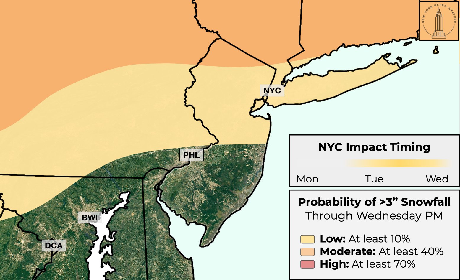
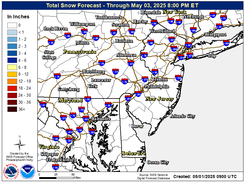
One thing we have on our side is the cold overnight temperatures. away from the heat island the ground will be frozen solid so anything that falls should stick. Every model besides the NAM is showing .3 to .4LE. So wherever that is all snow is 3 to 4" which right now is favoring North of the city as the 2nd wave seems to be gaining more latitude with each run. Will see if this reverses the next few cycles similar to what happened with the 1st wave

algae888- Advanced Forecaster

- Posts : 5311
Reputation : 46
Join date : 2013-02-05
Age : 62
Location : mt. vernon, new york
amugs likes this post
 Re: JAN 26th Light Snowfall
OK! Not the #Blizzardof2016 *womp*
— Kiyana Lewis (@kiyanalewiswx) January 24, 2021but it's something! At least 2" of snow expected Tuesday across #NYC.
Slippery and icy conditions are also expected, along with a messy morning commute. We're still a few days out, so there's time to plan accordingly! #NYCTough pic.twitter.com/CnrUaILfGw
_________________
Mugs
AKA:King: Snow Weenie
Self Proclaimed
WINTER 2014-15 : 55.12" +.02 for 6 coatings (avg. 35")
WINTER 2015-16 Total - 29.8" (Avg 35")
WINTER 2016-17 : 39.5" so far

amugs- Advanced Forecaster - Mod

- Posts : 15095
Reputation : 213
Join date : 2013-01-07
Age : 54
Location : Hillsdale,NJ
 Re: JAN 26th Light Snowfall
_________________
Mugs
AKA:King: Snow Weenie
Self Proclaimed
WINTER 2014-15 : 55.12" +.02 for 6 coatings (avg. 35")
WINTER 2015-16 Total - 29.8" (Avg 35")
WINTER 2016-17 : 39.5" so far

amugs- Advanced Forecaster - Mod

- Posts : 15095
Reputation : 213
Join date : 2013-01-07
Age : 54
Location : Hillsdale,NJ
 Re: JAN 26th Light Snowfall
_________________
Mugs
AKA:King: Snow Weenie
Self Proclaimed
WINTER 2014-15 : 55.12" +.02 for 6 coatings (avg. 35")
WINTER 2015-16 Total - 29.8" (Avg 35")
WINTER 2016-17 : 39.5" so far

amugs- Advanced Forecaster - Mod

- Posts : 15095
Reputation : 213
Join date : 2013-01-07
Age : 54
Location : Hillsdale,NJ
 Re: JAN 26th Light Snowfall
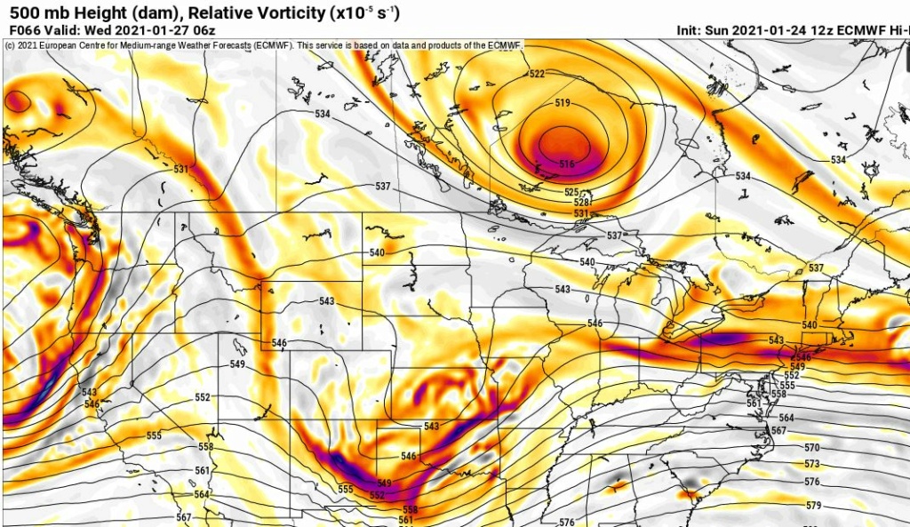
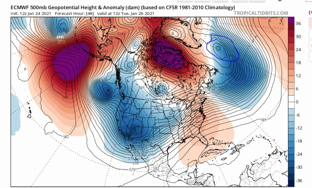
Look at where the Euro has this UL energy now on the PA/NY border. This is literally 200 miles north than 2 days ago. Most likely the reason is we really don't have the 50/50 low to pin this down as the low in now towards Greenland.
With this trajectory I feel most of the snow associated with this will this ULL will be just south of I90 corridor. The upside to this IMO for most will be WAA snow potential. I think that may be under modelled right now as the ULL being so far north is going to whip in warm air aloft.
RB may have called this a while back. I can't remember but if he did then kudos to him for seeing that 50/50 low going away.


heehaw453- Advanced Forecaster

- Posts : 3906
Reputation : 86
Join date : 2014-01-20
Location : Bedminster Township, PA Elevation 600' ASL
 Re: JAN 26th Light Snowfall
algae888 wrote:One thing we have on our side is the cold overnight temperatures. away from the heat island the ground will be frozen solid so anything that falls should stick. Every model besides the NAM is showing .3 to .4LE. So wherever that is all snow is 3 to 4" which right now is favoring North of the city as the 2nd wave seems to be gaining more latitude with each run. Will see if this reverses the next few cycles similar to what happened with the 1st wave
Nam has me (20 miles north of 84) with 1 inch and most other models have 3-4. Right now 2-4 looks like a good call N and W but would not be surprised if end result is 1-2. First opportunity for snow since early January when I picked up 3 inches.
hyde345- Pro Enthusiast

- Posts : 1082
Reputation : 48
Join date : 2013-01-08
Location : Hyde Park, NY
 Re: JAN 26th Light Snowfall
heehaw453 wrote:Look at where the Euro has this UL energy now on the PA/NY border. This is literally 200 miles north than 2 days ago. Most likely the reason is we really don't have the 50/50 low to pin this down as the low in now towards Greenland.
With this trajectory I feel most of the snow associated with this will this ULL will be just south of I90 corridor. The upside to this IMO for most will be WAA snow potential. I think that may be under modelled right now as the ULL being so far north is going to whip in warm air aloft.
RB may have called this a while back. I can't remember but if he did then kudos to him for seeing that 50/50 low going away.
There is a wealth of knowledgeable people on this board but in my time here, rb is the stud of the group. Always seems to be onto things more often and is so intelligent that's he's unintelligible.

Irish- Pro Enthusiast

- Posts : 788
Reputation : 19
Join date : 2019-01-16
Age : 45
Location : Old Bridge, NJ
sroc4, dkodgis and heehaw453 like this post
 Re: JAN 26th Light Snowfall
Nam Is 2 to 4" now for the city North and West. With the upper level low gaining more latitude I think will see increase in WAA snows from the 2nd part of this system. Where this sets up is anyone's guess as the models are having a tough time with this system look at what it does for DC 6" of snow for them with the 1st wave no other model has this

algae888- Advanced Forecaster

- Posts : 5311
Reputation : 46
Join date : 2013-02-05
Age : 62
Location : mt. vernon, new york
 Re: JAN 26th Light Snowfall
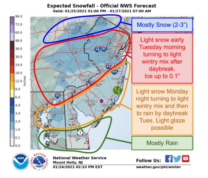
NWS coming inline now with calling this for what it is. I like this forecast but think that if the WAA doesn't produce then it's a coating below route 80. Hopefully the northern crew can cash in a bit, but still thinking the better snows are closer to I90. The ULL is just getting too far north I think.

heehaw453- Advanced Forecaster

- Posts : 3906
Reputation : 86
Join date : 2014-01-20
Location : Bedminster Township, PA Elevation 600' ASL
 Re: JAN 26th Light Snowfall
heehaw453 wrote:NWS coming inline now with calling this for what it is. I like this forecast but think that if the WAA doesn't produce then it's a coating below route 80. Hopefully the northern crew can cash in a bit, but still thinking the better snows are closer to I90. The ULL is just getting too far north I think.
Moving on, stick a fork in this one and thank it for delaying hours possibly screwing things for Thursday.

Irish- Pro Enthusiast

- Posts : 788
Reputation : 19
Join date : 2019-01-16
Age : 45
Location : Old Bridge, NJ
 Re: JAN 26th Light Snowfall
Here's my forecast for Tuesday from the NWS
TuesdaySnow likely before 4pm, then snow and sleet likely, possibly mixed with rain. Cloudy, with a high near 34. Wind chill values between 25 and 30. Northeast wind 7 to 11 mph. Chance of precipitation is 60%. New snow and sleet accumulation of less than one inch possible.
Tuesday NightSnow and sleet likely, possibly mixed with rain before 1am, then a chance of snow between 1am and 4am, then a chance of snow and freezing rain after 4am. Cloudy, with a low around 31. Northeast wind around 9 mph. Chance of precipitation is 60%. Little or no ice accumulation expected. New snow and sleet accumulation of less than a half inch possible.
WednesdayA chance of freezing rain before 7am. Partly sunny, with a high near 38. Chance of precipitation is 30%.
Hopefully I can get a little hail and graupel thrown in just so all the bases will be covered.
GreyBeard- Senior Enthusiast

- Posts : 725
Reputation : 34
Join date : 2014-02-12
Location : eastern nassau county
heehaw453- Advanced Forecaster

- Posts : 3906
Reputation : 86
Join date : 2014-01-20
Location : Bedminster Township, PA Elevation 600' ASL
 Re: JAN 26th Light Snowfall
Not much to track here. Closing the thread and we’ll carry the conversation on in the January thread
_________________
_______________________________________________________________________________________________________
CLICK HERE to view NJ Strong Snowstorm Classifications
Page 2 of 6 •  1, 2, 3, 4, 5, 6
Permissions in this forum:
You cannot reply to topics in this forum|
|
|

 Home
Home
